

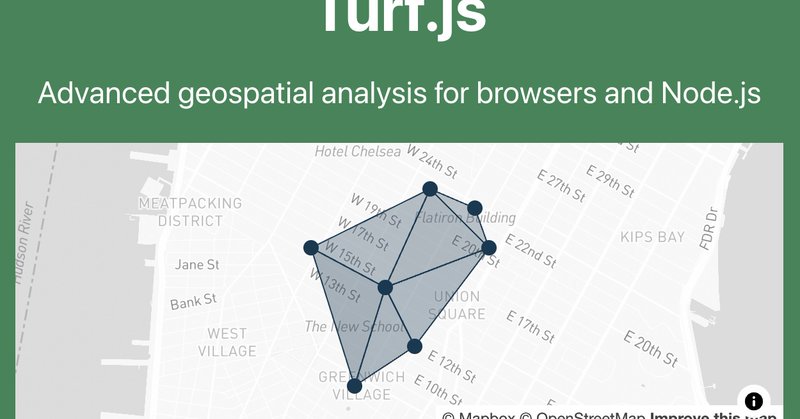
TurfJS
@turfjs
Followers
401
Following
86
Media
1
Statuses
67
Advanced geospatial analysis for browsers and Node.js. Support the project on https://t.co/bgF1kc60UU 🙏
Joined September 2015
Turf just released the long awaited v7! Loads of bug fixes, type improvements and features added in this release 🎉
0
2
7

Love that the @turfjs implementation for measuring Polygon area on the Earths surface come from a NASA Jet Propulsion Laboratory publication https://t.co/qPrSK6a7nr
2
1
4
Built with @Mapbox, @vite_js, @reactjs, @fontawesome, @tailwindcss. Data processing with @turfjs, and R (gtfsrouter package). Deployed on @Netlify. Code on @github.

Inspired by the rapid-fire experience of https://t.co/hrHmjUax3R, I built a similar interactive that shows how far you can get from each NYC subway station in 40 minutes. Have a look at https://t.co/uxsEH5arc3 👀
0
2
15

I love how easy it is to use JS libraries with @FableCompiler To use @turfjs I just need to specify which functions I need and what types I do expect #fsharp
0
4
17
10-20-30-40 minute isochrones for subway + walking(ish) from Atlantic Ave/Barclays Center. This is a @turfjs -intensive workflow, using buffer, dissolve, truncate, and intersect. Now to make them for the other 471 stations. cc/ @_benjamintd
0
1
7
After a bit of work the Turf.js docs should now be responsive and be an all round nicer experience on mobile/tablet than they were before!
turfjs.org
Turf provides advanced geospatial analysis capabilities for browsers and Node.js
1
1
8

This Pi Day, don't worry about using pi to calculate area - use Mapbox GL JS and @turfjs! This example from our Docs shows how to calculate the area of any mapped polygon. See it in action: https://t.co/eXX7QIty3l
#PiDay #gischat
0
4
15

A "new" way to find locations on a map, powered by @Mapbox & @turfjs. Search for a geolocation, change the center marker & drag to resize the radius zone. Pairs with @thatsfinsweet Attributes to update a filterable list. Coming soon!
4
1
20

0
1
2

Make your web maps look more like print – by overlapping a hidden symbol layer along a map edge you can avoid labels being clipped with @Mapbox and @turfjs. Play with it here: https://t.co/jF4enVbkFj
3
9
78


Thanks to @willy_maps idea and code, and a bit of help from @en_dash, I have now made a totally essential spidermap of trig pillars across Great Britain - shows the 8 closest trig pillars to the centre of the screen https://t.co/jWpRnTUJgL
37
128
705
130
1K
11K

Another day, another #dataviz. This time, Joy Division-style ridgeline map with altitudes on @observablehq with the help of d3 and @turfjs. #observable #datavisualization
https://t.co/ZDVQ1O2Y2W 🇺🇦
0
7
26
Calculating distance between 2 points in one notebook #fsharp, #javascript (with @turfjs ), #python (with geopy via @pyodide)
0
7
18

#30DayMapChallenge (late) Day 8 - Blue This map shows each European country's surface water area. The Netherlands has the highest percentage, with 10.35% of its area covered by water
2
3
30
Thanks to @turfjs for a powerful spatial analysis toolbox to enable this project.

I have open sourced code used to calculate walk potential for cities. Some assembly required. https://t.co/ixEG7K6GMa Here's an example use contrasting walk potential (green) with missing sidewalks (red). @samth
0
2
9

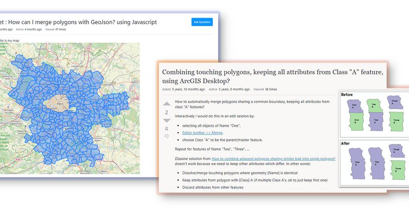
I just published in @JS_PlainEnglish A Neat Trick to Merge Adjacent Polygons in Spatial Datasets with Turf.js https://t.co/CWqxUSfRQs
#geospatial #ools #DataAnalytics
javascript.plainenglish.io
Use-Case + Code Implementation. Tool available at my GitHub.
0
3
2
