

Elizabeth Leitman
@WxLiz
Followers
39,323
Following
3,158
Media
6,029
Statuses
52,255
Severe Storms Meteorologist - wife/mom - ENTP - book/music lover - poetry/lyrics - ADHD/mental health advocate - STL sports. Thoughts mine, not employers.
Norman, OK
Joined August 2012
Don't wanna be here?
Send us removal request.
Explore trending content on Musk Viewer
Amethi
• 174270 Tweets
Knicks
• 144074 Tweets
राहुल गांधी
• 135243 Tweets
Sixers
• 73084 Tweets
Brunson
• 71152 Tweets
憲法記念日
• 67081 Tweets
#Raebareli
• 64027 Tweets
Embiid
• 58946 Tweets
स्मृति ईरानी
• 23868 Tweets
Smriti Irani
• 23505 Tweets
Hayırlı Cumalar
• 22826 Tweets
Tobias Harris
• 22082 Tweets
Pachuca
• 21751 Tweets
ゴジラ-1.0
• 21127 Tweets
Josh Hart
• 20654 Tweets
Hield
• 17043 Tweets
KerenTIMNASKU STYdanERICK
• 16521 Tweets
Pumas
• 16100 Tweets
TetapSMANGAT GarudaMUDAKU
• 15800 Tweets
DONBELLE IN SOCCSKSARGEN
• 11392 Tweets


Y’all, my feed is filled with scientists, photographers, science enthusiasts, and non-science people alike. How cool is it that at least for a few moments, everyone was sharing in the joy and wonder that is our sky, planet, universe? More of this all the time please!
44
1K
12K
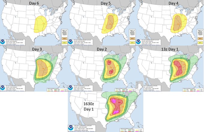
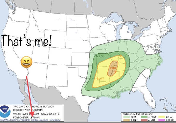
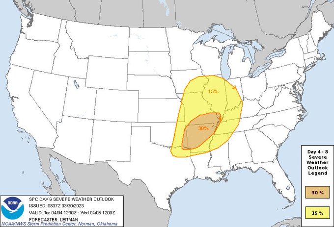
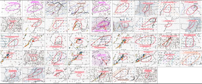
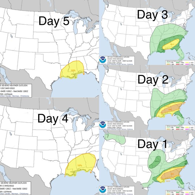
How did we get to today's forecast? The first area was highlighted in the Day 6 outlook, nearly a week in advance. As we move closer to the event in time, areas are honed and corridors of greater potential identified.
74
408
2K
I’m surprised by the number of comments from non-weather folks saying NHC missed the forecast on Ian. NHC had fantastic forecasts and excellent discussions noting uncertainty in landfall. Media partners communicated this well. Was this message not received by public? Why?
244
98
1K
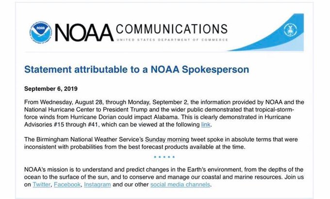
I am proud to work for
@NWS
. You will not find a more dedicated bunch, committed to saving lives and helping communities. But I am utterly disappointed and embarrassed by our parent agency’s actions today. The damage done to relationships built on trust is worrisome at best.
50
280
1K
It’s blowing my mind that I’m seeing some people on here say Norman had no warning. 1. This event was well-forecast days in advance. 2. NWS Norman issued the tor before the tornado developed and 10-15 min before it first hit town. Sirens went off, cell phones & WxRadio alerted…
94
118
1K
It’s been a bit busy & chaotic but everyone at OUN, SPC & NWC are fine. Tornado just missed us at the building. We saw power flashes from ops & briefly lost power (we have backup power though so didn’t impact anything). Tornado missed my house by 1/2-3/4. Family was sheltering.
72
81
1K
Not tooting my horn AT ALL. How amazing is it that we can pinpoint a corridor of higher tornado potential 6 hours in advanced, more focused 1 hour in advance, of a high-impact tornado event? It cost individuals < $3/yr to fund NWS. Thank you for supporting us, so we can help you!

25
194
983
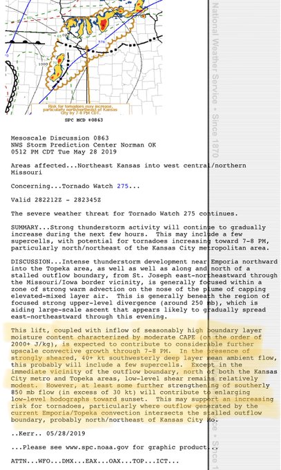
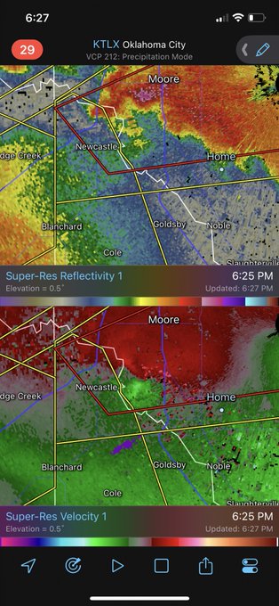
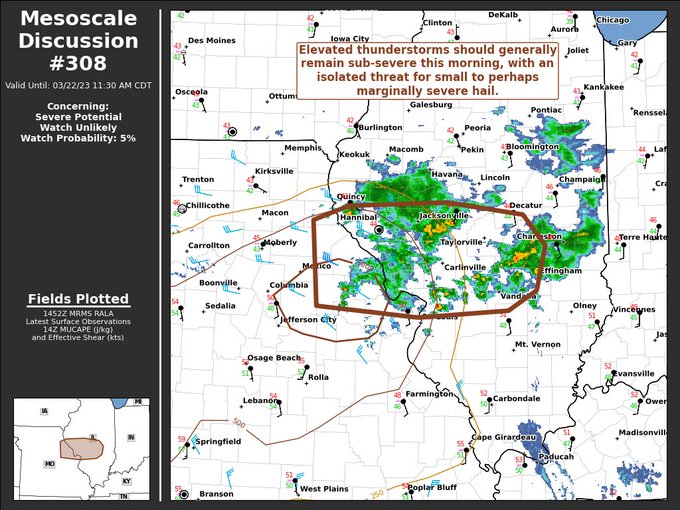
How's this for a tornado proximity sounding? 03z observed sounding from Norman. Tornado in Norman about 15-20 minutes later. LOOK AT THAT CAP! Insane mass flux along the frontal boundary and intense forcing blew that lid right off. Fascinating!

52
179
922
I’ve worked
@NWSSPC
for almost 10 years and I still get giddy when I see my name on products. 😂 I know not everyone gets to work their dream job. I’m
#blessed
!
#FridayFeelings
25
25
856
Dude misspelled awesome.


149
2
19
33
36
828
I’m off work today. But when your hobby/passion and job are all the same….yeah, I’m not a good example for work/life balance. 😬 I’ll take a break tomorrow.

64
21
815
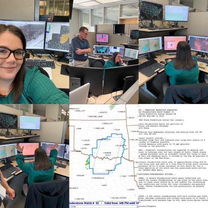
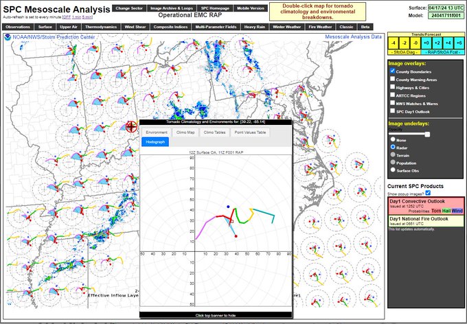
New feature on the SPC Mesoanalysis page: Mesoanalysis hodographs! Double click anywhere on the map to bring up the table with environment parameters and climo tables and it’s the last tab. There must be 100 MUCAPE for the hodographs to plot.
43
162
809
Reports will continue to trickle in today, but here is how things stand as of 950am CDT.

23
161
754
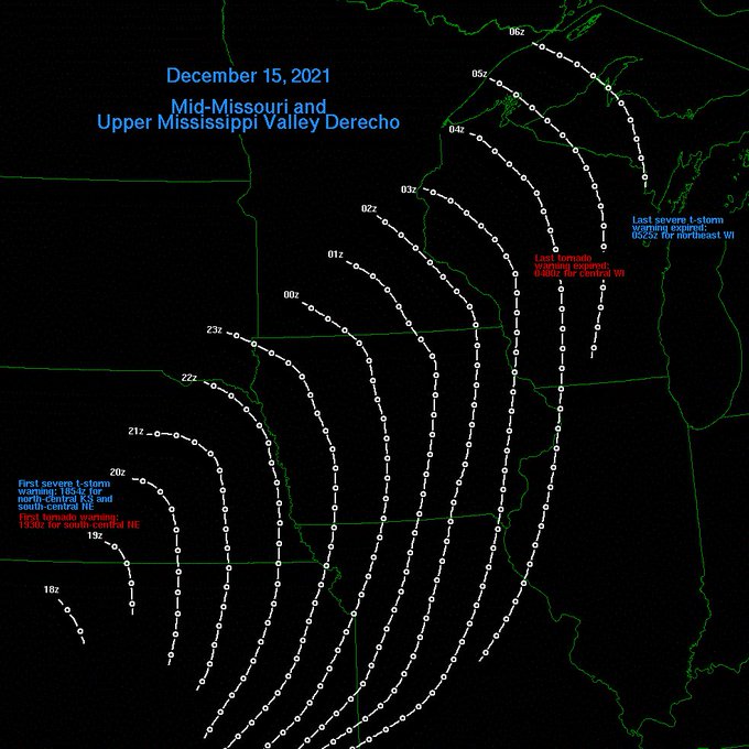
Quick graphic with the position of the 15 Dec 2021 derecho. First and last severe/tornado warnings are noted. The derecho traveled roughly 660 miles in 10.5 hours, giving an average forward motion of 63 mph. That’s faster than some interstate speed limits in Iowa.
19
240
747
Y’all, be real. I don’t care if you’re 18 or 30. Morals & knowing right from wrong should be obvious well before then. My 9 year old knows harassing women is wrong. He knows being hateful toward anyone is wrong. Educated men shouldn’t need their hand held through early adulthood.
28
76
741
This is 40. 😱 I guess all that matters is I still feel 25, right? 🤪

231
7
735
Today is my 17 year NWSiversary! I have seen a lot in that time, from wildfires and damaging wind storms to historic ice storms, record flooding, and devastating tornado outbreaks. I love my job (even if my body is starting to hate the shift work 😅).
56
8
733
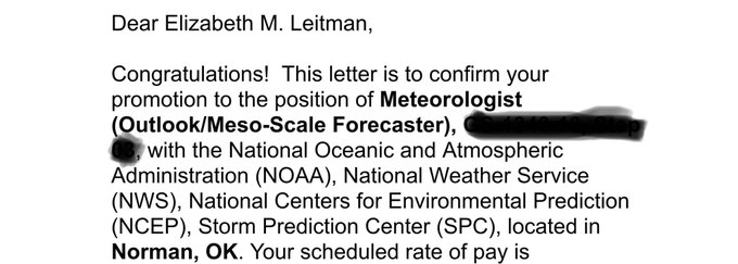
I’m so excited to say I’ve accepted a promotion
@NWSSPC
from Mesoscale Assistant/Fire Wx Forecaster to the Outlook/Mesoscale Forecaster position! This has been my dream job since I was a kid! It’s an honor and a special privilege to be the first woman in this role!
#WomenOFNOAA
102
12
688
Apparently (according to the internet) we are experts in our field, don’t know anything, do a great job, are wrong more than 50% of the time, are the best of the best, 14 year olds with weather apps are better, most couldn’t do what we do, am an idiot, am a genius… 1/3
72
84
697
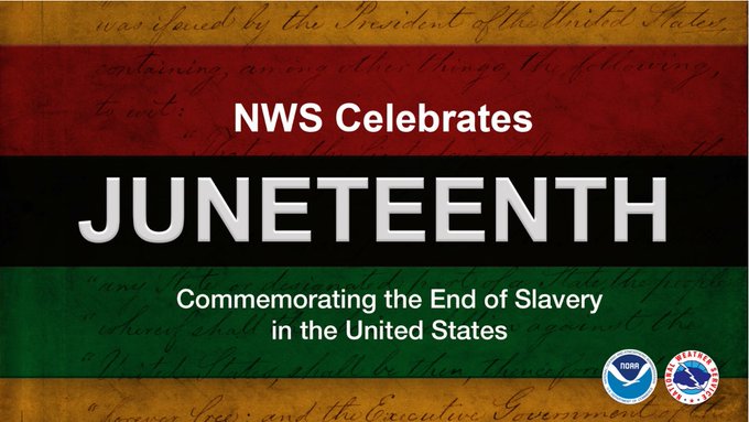
Incredible that people get pissed over the NWS, a federal agency, making a post about celebrating a federal holiday. One that celebrates freedom, justice and equality. People are so disappointing - and that’s being kind. Seriously people, wtf?

Join us today to celebrate freedom and recognize Juneteenth as a reminder to promote equality, respect, and justice for all. May we continue to work together towards future progress.
#Juneteenth
93
196
1K
52
62
657
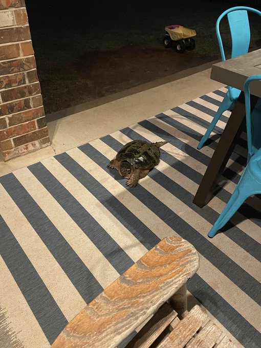
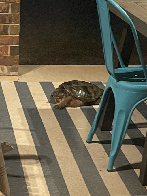
This absolute unit of a snapping turtle is currently sheltering on my patio.

51
16
654

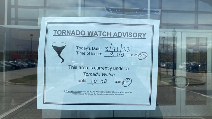
This is amazing!! What a great idea to keep people informed about potential severe weather!

This is a brilliant idea for businesses, informing the public about incoming severe weather. Saw this this afternoon while walking into the movie theater.
#wxtwitter
27
213
1K
18
71
606
🧵: "How do you create the SPC Convective Outlook?" I get asked this question a lot. So, I'm going to touch on a little bit of the process. This is not all-inclusive, but should give a better idea of what goes into creating an outlook that looks like this:
33
119
587
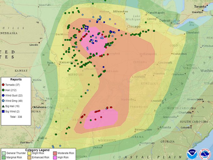
Storm reports so far (at of 8pm). More reports are expected, as storms are ongoing/continuing east toward the Ohio & TN Valley through tonight. Most of the tornado reports received so far have been in/near the the High risk areas. The expected bi-modal nature is also evident.
25
144
590
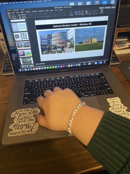
Today is special. 1 yr ago I became the first female forecaster at SPC to issue a watch. Today, I’m prepping a talk while continuing to support women & girls in science while sporting this amazing
@GirlsWhoChase
friendship bracelet made by
@juststormchasin
!
💜🌪️🩷
#chasindreams
32
38
587
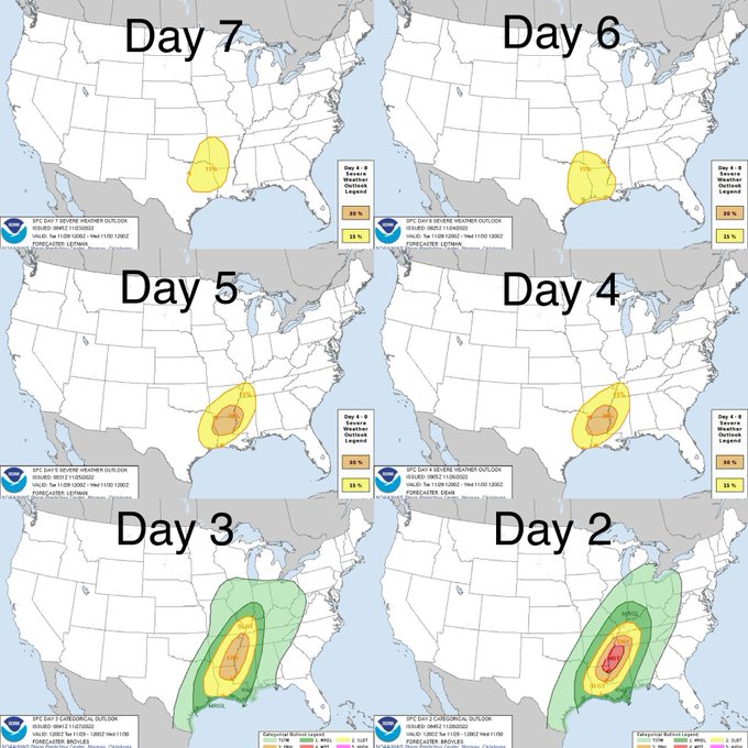
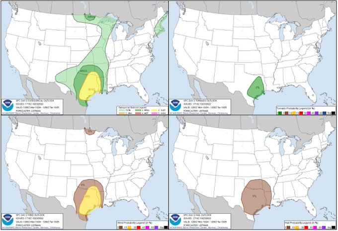
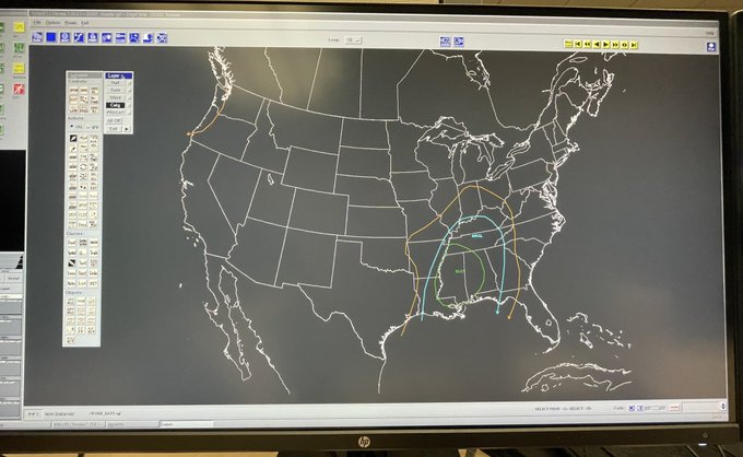
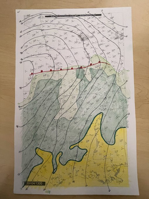
Put together this graphic of outlooks for today, starting with the first area introduced at Day 7. Initially guidance showed a stronger cut-off low ejecting slowly into the Plains, which would result in a more westward threat. By Day 4/3 it became apparent things would... (1/3)

35
91
579
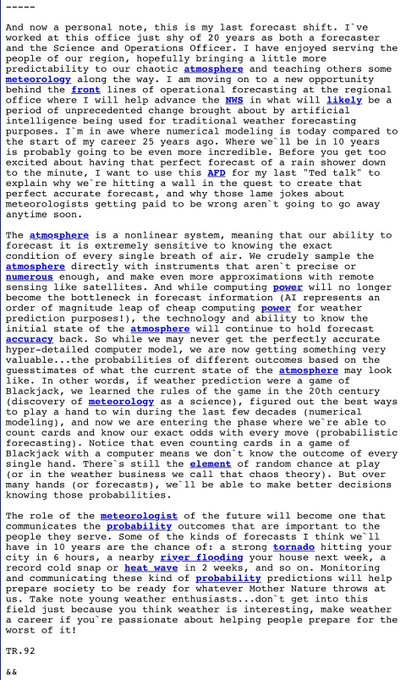
Must read special note from the NWS Fort Worth SOO on his last forecast shift. Wonderful insight and advice.

A powerful read in the NWS FWD discussion today. Everyone should give this a read
30
483
2K
13
89
588
I have seen a troubling amount of misinformation about the eastern Canadian wildfires. There Is no conspiracy. They were started by lightning. Why do you see smoke plumes take off all at the same time? Hot, dry, windy conditions w/ some atmospheric instability.

38
151
546
Catastrophic…

32
26
539
The response to this moment has been incredible. I never anticipated how excited so many people would be to share this story. While the spotlight isn’t my comfort zone, I couldn’t be happier to represent women in meteorology and, more broadly, STEM. ❤️

33
42
545
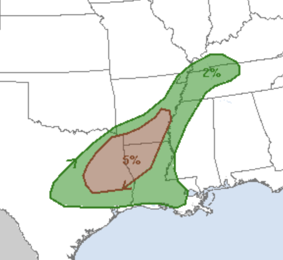
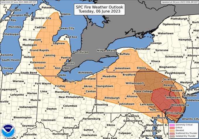
We’ve had severe questions about the last time a Dry T-storm area was in the Northeast. None of us can recall it ever happening and are fairly confident this is a first.

A highly unusual scenario supporting wildfire spread is possible today across parts of the Northeast. Dry/breezy surface conditions and dry thunderstorms are possible this afternoon. Gusty, erratic winds may also accompany the storms, further aggravating fire conditions.
17
351
777
26
143
527
I thought I’d have to wait until at least mid-March before getting to issue a tornado watch, but
@SkyPixWeather
let me handle the watch while he was writing up the 13z Day 1 Outlook. 🙌🏼
#teamwork

32
33
522
I know most of you are looking at the tornado, understandably. But as a structure hipster, my first thought was, “look at that RFD cut!” 😍😂 Seeing the whole storm dynamic just does it for me. Great spotting location by John here!

25
33
523
Props to NWS Cheyenne for this message. NWS is making big gains, in big part thanks to
@LatinWx
, in reaching Spanish speakers w/ our info. Spanish is the second most spoken language in the US, with over 41 million speakers. We serve all of the U.S. & our info should be accessible

Some of our recent posts have been in both English & Spanish. In response, there have been many racist comments. 27,000 WY & 129,000 NE residents speak Spanish & it's the 2nd most common language. Racism & bigotry will not be tolerated. Your comments will be promptly removed.
207
1K
13K
14
46
514

Keep your fingers crossed and hope things go well and you might see something cool on the SPC website on Wednesday. 👀🧐
66
34
514
Teary mom moment. I’m not usually a very sentimental person. But my sunshine girl had Kindergarten promotion yesterday and I’m so proud of her. She could have very easily not been here at all, so every moment with her is a gift. 🥰🥹

22
0
516
Just because the TV meteorologist was focused on OKC and not Norman doesn’t mean there wasn’t warning. Don’t wait for the TV to tell you what to do. This is why we say have multiple ways to get warnings.
15
28
512
Going to drop a thread 🧵 later today answering the question “How does SPC make a convective outlook?” Hint: by hand, no automation creates our outlooks, but the probs do determine the category. I’ll walk through each step in my process, focused on the Day 2 outlook. Stay tuned.
28
44
498
Can we please put a lid on posts saying Monday is going to be a High risk. Honestly, it doesn’t help anyone. Talk about the meteorology all you want. Go gangbusters discussing it. But also, let mets do their job. Communicating risk is hard enough without hype.
44
66
494
While I’m confident the tornado threat will be north of my house, my daughter is terrified of storms. So, here we are… whatever makes her feel safe.

18
10
485
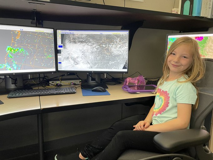
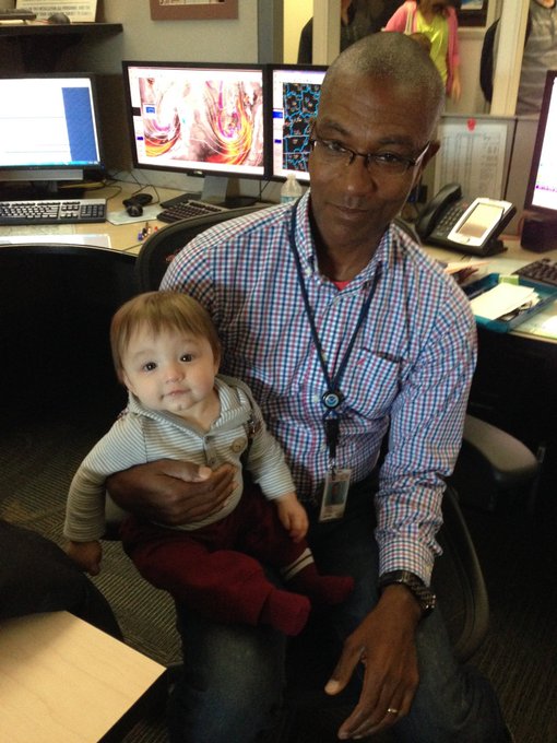
Had a little help at the lead desk from Littlest Leitman at the end of my shift. 🥰
#womeninSTEM
15
13
487
Getting ready to head into the office to work an event that may impact your own family’s and community’s safety always adds a level unease. Remember, the people who forecast and warn for these events live and work and have family in these areas too.
18
33
479
Just in case Twitter implodes soon-ish, just wanted to say I appreciate y’all. I’ve made great friends & built professional relationships while getting to talk about what I love - severe storms. The community here has for the most part been wonderful. I hope it doesn’t burn down.
39
10
470
I want reiterate my statement from a few days ago. SPC works as a team. No decision is made in isolation. Ops is made up of 22 world-class experts and we’ve got a dozen more incredible science support & research staff that help make us great. They all deserve high fives. 🙌🏼
I’d just like to point out I have the best coworkers on the planet. At SPC, no decision is made in isolation. We are a team. When the midshift got in last night the first thing I told them was “if you have thoughts on Friday, I’m open to hear them.”
15
21
416
19
22
464
Y’all, I can’t believe I need to say this:
Anything you hear from a “chaser” saying SPC is going to XYZ and Not Likely O’Clock should not be taken seriously. You’ll know what SPC is going to do when we issue an official product. (1/3)
18
43
465
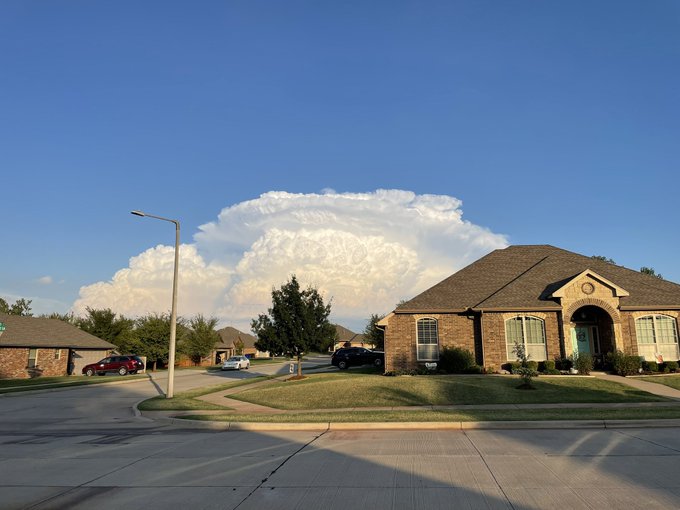
Nice view out my front door of the storm east of Norman.
18
18
461
Nearing the end of my shift and I’m exhausted. Mentally, emotionally, physically. My heart is heavy.
Nod of recognition and appreciation to all of the mets and 1st responders who worked the severe storms outbreak yesterday/today. You all are exceptional.
17
18
451
🧵: I’d like to address the comment/question I’ve seen a lot over the past few days so it won’t get lost in other threads/replies.
“Why did it take so long for a woman to issue a severe thunderstorm watch?”
A few reasons, which I’ll address with context, in this thread.
11
74
459
I don’t deal well w/people leaving, so I shed a few tears today when I left work. My coworkers are family. Give a shout out of appreciation for Meso/Outlooker Greg Dial who is retiring after 23 years at SPC (and 32 years w/NWS). This is him at work with my now 8 year old son. ❤️
20
9
446
Issuing warnings in radar gaps is hard. The warning forecaster uses a mix of radar, their knowledge of what the storm environment should be capable of, and if we’re lucky, visual reports of what’s happening with the storm. 1/x
13
65
446

Congrats to NWS SPC, DVN, LOT, ILX, & CWSU ZAU for receiving the NWS Director’s Award for outstanding services leading up to/during the March 31, 2023 outbreak! 🎉🙌🏼 Great work y’all!
This event was outlooked 6 days in advance, w/ a double high risk upgrade & over 1000 reports!


16
62
440
I put together some quick info on Saturday's derecho event. Only two other derechoes in the Great Basin are well noted in literature. I've included storm reports for those events, as well as a derecho frequency map for comparison. Pretty remarkable event!
#derecho
#wxtwitter

26
145
423
It’s alarming how so many people are willing to immediately accept information at face value on this platform. No questions asked, no waiting for more info, no knowledge or frame of reference for basing their propagandized opinions. This is not the place for me anymore. ✌🏼 out.
61
35
384
If much hasn’t happened in the souther Moderate risk are by late tomorrow afternoon, can WxTwitter have some patience? The souther threat mainly expected during the evening/overnight period. Daytime supercells May be more likely near the warm front further north. Patience.
33
47
427
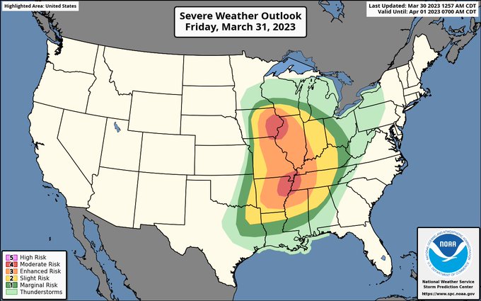
Ending this set of outlook shifts with a bang. Moderate risk Friday, and another quite concerning day shaping up for Tuesday. Spring severe season is well underway. Stay safe y’all. Get those weather radios ready!
22
72
432
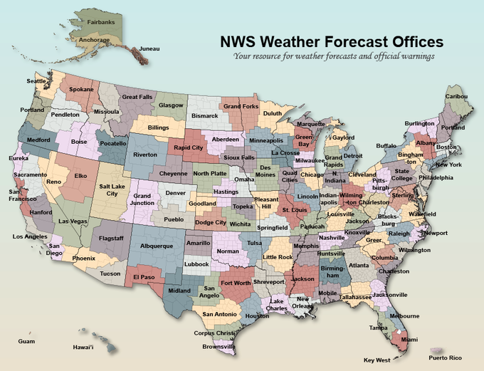
When non-weather people discover NWS local forecast office boundaries. 😂 My favorite comment: “This makes no sense.”

36
20
422
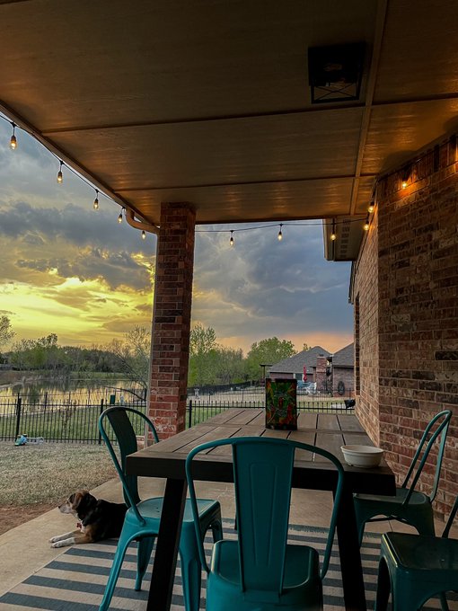
Just sittin’ on the back porch, watching a severe-warned storm to my north at sunset. I can smell rain and hear thunder. My heart is happy.
17
4
423
Doing this New York Times interview was a surreal and fun experience. Thanks for sharing my story & highlighting the world-class experts at the SPC! As stated in the article, I’m lucky to work with people I idolized as a teenager. Grateful for the awesome team here.
20
27
419
I don’t care what color or gender you are, what religious beliefs you hold. If you are kind and empathetic, I wish you peace and joy. If you are hateful and arrogant, please have the day you deserve. ✌🏼
7
33
419
I’d just like to point out I have the best coworkers on the planet. At SPC, no decision is made in isolation. We are a team. When the midshift got in last night the first thing I told them was “if you have thoughts on Friday, I’m open to hear them.”
15
21
416
Claims like this is why legitimate climate concerns lose credibility. And using one out of context study to justify your argument doesn’t mean you’re correct. Stop with theatrics. It’s disingenuous and does nothing to help.
17
52
420
Panic attacks are exhausting.
I’m going to be stepping away from Twitter for a while. Y’all take care, be safe, and try to love a little more and argue a little less.
31
5
412
I’d like to address some questions I tend to get frequently wrt SPC.
1. Don’t ask if an outlook will be upgraded or a watch will be PDS, etc. It is against policy to share pre-decisional information publicly. Often we don’t even know until just before a product is issued. 1/x
25
61
412
I just had one of the most surreal moments of my life. My friend Logan sent me a picture of this poster. It was a preorder incentive for
@TheSpaceGal
’s new book Next Level. I’m the purple square! 😭🥰 So cool! Humbling to be included with these other incredible scientists!
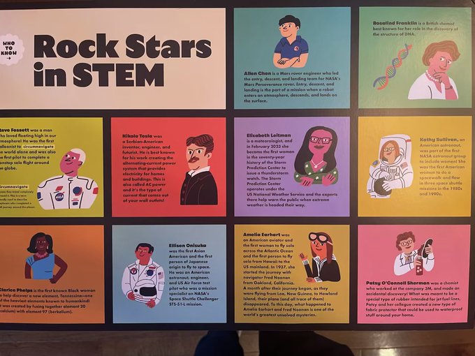
38
45
414
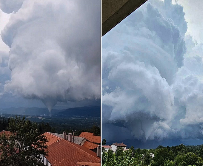
Wow. Tornado in Slovenia. What a view!

8
41
411
I’ve been staring at the weather for 18 hours now. My eyeballs feel like they are on fire, so I’m going to sleep.
In all seriousness though, I’m glad the forecast was accurate, hopefully it helped. I absolutely hate seeing the outcome though. My 💜 is with those impacted.
24
9
410
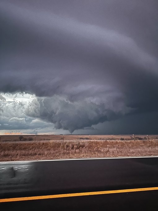
The evolution of this tornadic storm in MS is mesmerizing to watch.
11
47
403
Some of the stuff I’ve seen posted on here the past couple days just has me wanting to peace out. Some of y’all are toxic and suck the joy right out of this community. Your dose of perspective will catch up to you one day and that’s going to be some tough medicine to swallow.
57
11
407
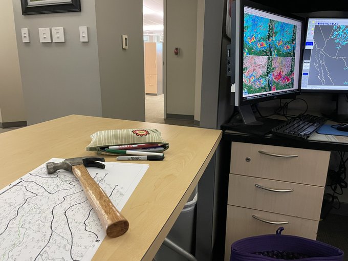
Was looking ahead in my schedule to plan & realized I start training on the Lead desk at work in a few weeks. Eeek! I’m incredibly excited & also mildly scared. Mostly I’m grateful to get the opportunity & really proud to be the first woman to work the lead desk once trained up.
53
3
410
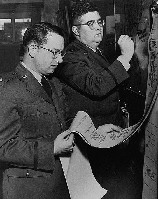
Today is the 76th anniversary of the first successful tornado forecast. The forecast was made by Lieutenant Colonel Fawbush and Captain Miller after tornadoes struck Tinker AFB in OKC 5 days earlier. A tornado struck the air base again on March 25, 1948, verifying the forecast.

Happy Fawbush and Miller day to all who celebrate. 🌪️
3
27
105
11
95
390


🧵: A new crop of Mets w/ great potential are getting ready to graduate & enter the professional sphere, here’s my unsolicited advice for success after 17 years in the biz:
*Be humble. Over confidence & egoism will kill you in this business. Predicting the future is hard.
14
62
387
Y’all, please don’t freak out over the MCD graphic reverting to the old style. We have redundancy built is to revert to old-style graphics if an error occurs in product generation. We issue time sensitive, important information & never want a product delayed so we have fail safes
14
35
383
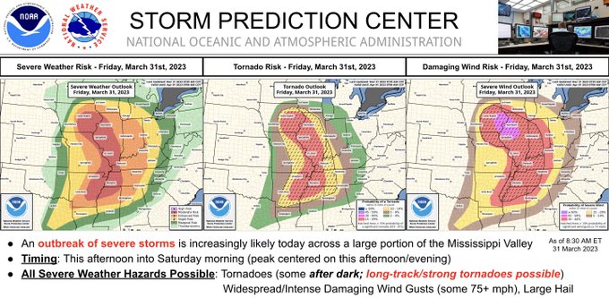
Wording we don’t use often: strong to violent tornadoes. If you’re in the MS Valley from IA/IL/MO to AR/KY/TN/northern MS pay attention to the weather today! Turn on weather radios, cell phone alerts, local TV. Know where you’ll shelter if needed. Be safe y’all.
A severe weather outbreak appears increasingly likely this afternoon/evening across a large portion of the Mississippi Valley. At least a few long-track, strong to potentially violent tornadoes are probable. Swaths of intense damaging wind and very large hail are also expected.
40
981
2K
8
152
383
A lot of people were celebrating news of Twitter not limiting automated tweets for NWS accounts. However, that news was from an unofficial source and is unfortunately not true.
Have multiple ways to receive Watch/Warning info. Please, buy a weather radio!

27
128
375
My advice to young meteorologists: know whose and which opinions matter (it’s not rando keyboard warriors). Value constructive criticism. Reflect on wins and losses thoughtfully and be glad for all outcomes - that’s building experience and learning. Ignore the rest. 3/3
17
22
383
Now that the cap is gone and SBCAPE has gone from 3500 to nearly 7000 (!!!!) between 17z and 19z at FWD, sig hail estimate has increased from 2 inches to 4.2 inches. 😅


16
68
372
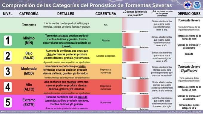
A comment on SPC outlooks, hazard probabilities, categories and intensity. *SPC probabilities are COVERAGE, not intensity* The SIG (hatched) area on a probability is the only true indicator of intensity that we issue. The category (level 1-5, Marginal-High) is determined… (1/x)
9
54
373
Some thoughts on today’s severe event: This forecast was incredibly challenging and I didn’t feel extreme confidence issuing that initial Day 5 area. Guidance remained muddy for several days and uncertainty had remained pretty high even going into the initial Day 1 period.
32
34
366
How is everyone doing?
I’m struggling myself. Just a reminder that it’s ok to not be ok. It’s ok to feel whatever you need to feel. It’s ok to not have it together all the time. I sure as heck don’t.
83
4
365