Sam Soud
@Ssoudwx
Followers
91
Following
336
Media
25
Statuses
156
Photographer & Storm Chaser. Card carrying Floridaman.
Jacksonville, FL
Joined September 2022
Storm chasing will face a reckoning at some point with the growing pains from the highest interest in the hobby to date. Every chaser eventually faces a reality check, that full stop, the realization that situational awareness is gone strikes again. Our sentinel event might
New @junefirstwx video. With the explosion in chasing popularity thanks to video games, content, & movies, another El Reno tragedy is more a question of WHEN rather than IF. I looked into the factors that made El Reno deadly to chase & how it can happen again in the future.
8
14
160
6/8 was a fun day despite being a bust for tornadoes. Wind-sculpted structures over good terrain provided some very picturesque stormscapes. #txwx #wxtwitter
0
2
14
#Aurora in Oklahoma! Thunderstorm underneath 📍Buffalo, OK #okwx @SevereStudios @MikeMorganKFOR @BlueSkyBust
14
195
1K
Sikeston intercept is up! Very excited to share this footage, got up close & personal on this tornado w/@Ssoudwx, @TheSilverHorsey Full Video Below! ⬇️ (Reposting because algorithm is a darn stinker)
2
6
46
Aug 16: Images from @NOAA_HurrHunter and the @NOAASatellites Ocean Winds team show an intense eyewall in Hurricane #Erin This photo shows the ocean surface calm in the eye and roaring in the eyewall. For the latest forecast visit https://t.co/tW4KeGdBFb
74
1K
5K
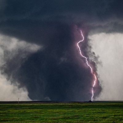
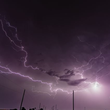
A lightning lover's dream night. 5/26/2025 near Burns Flat, OK on the backside of a marginally severe MCS. @hunterhurleywx @CowboyWx @TheSilverHorsey #okwx #lightning
1
1
16
By now some folks have probably seen early versions of Report Buddy floating around. Holden snagged the first tornado pic with it. Ill be open sourcing the code that started as a personal replacement/enhancment for spotter network and mping. https://t.co/vBQldOqGco
11
18
119
Also, special shoutout to Joey Prom for walking in front of my timelapse multiple times lol
0
0
0
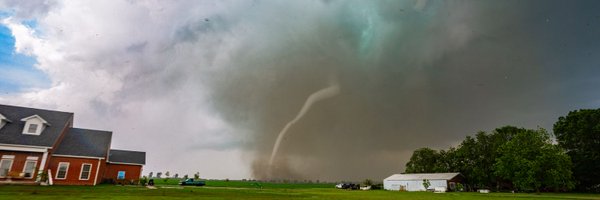
Silverton, TX Anticyclonic tornado on 4/24, full raw timelapse from birth to death. If anybody knows how to get manual removal to export with 300+ images in lightroom, please let me know, LR decided to not process the removal on the export for half the images lol...#txwx
1
2
2
This was awesome to capture while filming the Gary, South Dakota tornado on Saturday. Absolute madness.
38
185
1K
The Wellfleet Tornado!!! Short little timelapse feature I put together of the incredible Wellfleet Nebraska Tornado! My Best timelapses to date!!! The ULTIMATE TORNADO TIMELAPSE!!! https://t.co/YLRjUBHkLa via @YouTube
#newx #Nebraska #StormHour #Nikon #nikoncreators
4
14
50
Finally pulled the raws from Arnett on May 18th, what a beautiful sequence it was!
2
6
41
In my experience, it's a balance. Balancing venting with updraft size, and a little help from drier air aloft, is what governs storm mode. This isn't scientifically backed afaik, so it could very well be a correlation =/= causation thing - I'd love to be proven wrong. /end
1
0
1
El Dorado, 5/23/24. Despite a large supercell, very strong UL winds created efficient venting to support the larger updraft, and very dry air aloft helped sustain a classic mode for the majority of the day.
1
0
1
Custer city, OK - 5/19/24. Despite modest pwats, the directional venting was poor, despite relatively strong UL winds. Due to this the updraft got progressively larger over time as warm, wet RFD led to increasing updraft size.
1
0
1
Silverton/Matador. As the updraft got larger, the storm got progressively more HP. Tornadoes were still visible, however a good amount of precip was falling around the updraft at its peak, owing to the supercell becoming large enough that the venting became insufficient.
1
0
1
Arnett, 5/18 this year. Very efficient venting aloft helped this cell remain LP - dry air entrainment also led to a much smaller updraft, which assisted with keeping the storm LP despite fairly high moisture content.
1
0
1
Sikeston/Blodgett, MO on 5/16. This supercell was actually particularly large, one of the larger ones I've been on, but it remained LP/classic owing to the incredibly strong upper level winds that vented precip away from the RFD and updraft.
0
0
4
To summarize, moisture exhaust through venting relative to updraft size is my pet theory for what generally governs the hp/lp debate. Examples below: 6/x
2
0
2
