

Michael Lowry
@MichaelRLowry
Followers
33K
Following
11K
Media
3K
Statuses
23K
Hurricane Specialist & Storm Surge Expert @WPLGLocal10 Miami. Alum @NWSNHC, @FEMA, @weatherchannel, @UCAR_CPAESS, @DeptofDefense, @FLSERT. Posts my own.
Joined April 2012
Today the pioneers of hurricane season forecasts issued their first outlook for 2025 amid gathering storm clouds at NOAA and the National Weather Service. Lots to discuss, including the potential impacts of DOGE on the upcoming hurricane season ⬇️.

2
6
10
Beautiful tribute from @NOAA_HurrHunter who earlier this evening honored longtime radar scientist and researcher Peter Dodge who passed away in March 2023. His ashes were dropped in the eye of Category 5 Milton tonight –.PETER DODGE HX SCI (1950-2023) 387TH PENNY

131
1K
8K
I'm not sure how many truly grasp what just happened tonight with Hurricane #Ian. It went through a full eyewall replacement cycle, hardly blinked, grew by 50% (as measured by its RMW), and delivered the 3rd highest storm surge since 1913 to Key West in the process. Just wow.
150
2K
7K
Category 5 Hurricane #Irma closing in on the Leeward Islands with sustained 185 mph winds. Catastrophic damage expected along its path.
182
3K
4K
The Atlantic Ocean has a lot to say right now. And none of it is particularly good. My take on the deep Atlantic heat – which blows May 2005 out of the water – how it could impact hurricane season, and how it's affecting us today via @CC_Yale
49
710
3K
We can squabble over what's behind the rapid Atlantic warming, but it's truly extraordinary to see waters in the Main Development Region of the tropics as warm in June as they typically are the first week of *September*. An undeniably big player this hurricane season.
82
940
2K
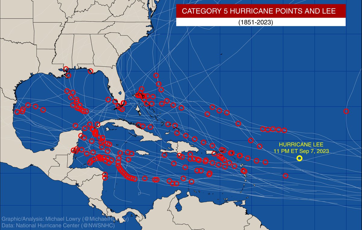
Hurricane #Lee is in elite company tonight. Fewer than 1% of all tropical cyclone "fixes" ever attain Category 5 strength. Lee is the farthest southeast we've ever observed a Category 5 hurricane in the Atlantic since records began 172 years ago. Lorenzo (2019) the farthest east.
51
627
2K
Only four named storms this century have been as large over the Gulf of Mexico (measured by the extent of tropical storm winds) as Helene is forecast to become by tomorrow:.Irma (2017).Ike (2008).Ivan (2004).Isidore (2002)

78
566
2K
I know others have tweeted something similar, but to see a catastophic Category 5 hurricane closing in our 3rd most populous state is wildly unnerving. #Dorian is already a disaster for so many tonight. Please, please heed the warnings of local officials in the hours ahead.
73
667
2K
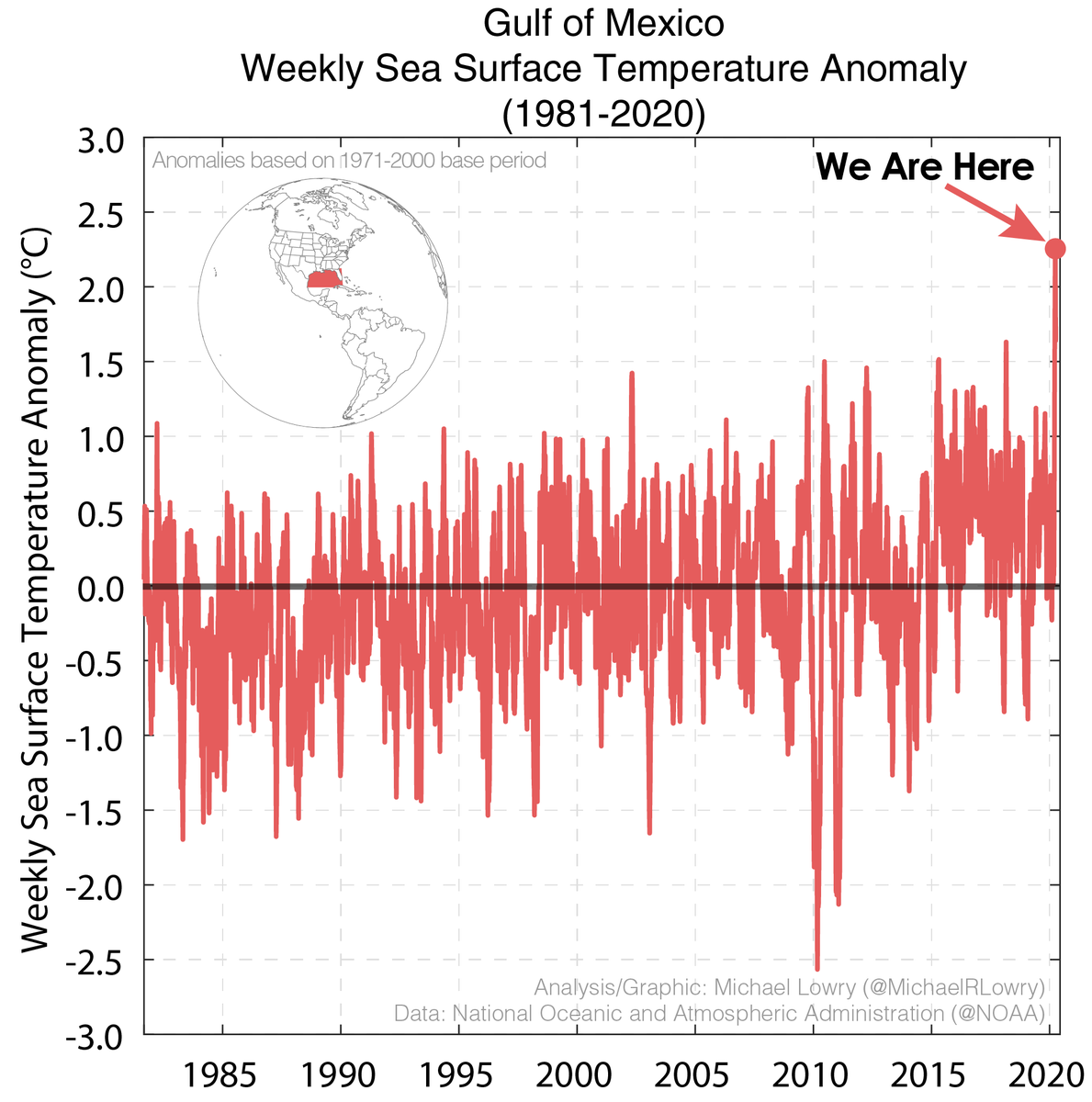
The Gulf of Mexico this week is the hottest it's been at any point in any year on record by a wide margin. Weekly averaged Gulf sea surface temperatures have never broken 87°F but this week topped 88°F, an astonishing 1.4°C (2.6°F) above the 1991-2020 average.
131
935
2K
It's hard to overstate how catastrophic this would be for hurricane forecasts. Should Congress approve the move, it would undo 50 years of hurricane forecast improvement. The folks taking a broad ax to climate are hacking away decades of progress to life-saving weather forecasts.

The Trump administration plans to eliminate the research arm of National Oceanic and Atmospheric Administration, close all weather and climate labs and eviscerate its budget along with several other NOAA offices, according to internal documents obtained by CNN.
67
684
2K
This is woefully dishonest. This was taken from a C-17 ~40 min from Oahu, not CA (and not by Peter Singer). The glow is from a sun angle below the horizontal plane illuminating shallow altocumulus clouds. Not fires. Not lava. Thankfully I don't believe everything on the twitters.
36
588
2K
I don't know what this means, but I'm the one who wrote a fully updated, 624-page hurricane response plan at FEMA that took over 2 years of work and careful coordination among state and federal agencies. He could start by studying that.

Exclusive: Two weeks from hurricane season, FEMA's leader admitted privately he doesn't have a full plan yet
28
539
2K
The last frame of this satellite loop of rapidly strengthening Hurricane #Otis is numbing. It's intensifying at a rate I've not seen — faster than satellite estimates can keep up with using practical constraints. Nearing Cat 5 on approach to Acapulco, Mexico. Horrific scenario.
42
468
1K
Not a great sign when mesovortices – little fingers curling into the eye from the eyewall – start showing up on radar and visible. These play an essential role in the strengthening process. Also it's (partly) why we say NEVER go out during the eye. They're extremely dangerous.


18
263
1K
Sea surface temperatures along Hurricane Beryl's track are running at record or near record levels for the week, with a deep reservoir of ocean fuel. Waters are as hot as they are typically are in late August and September, no doubt a big player in Beryl's record June intensity.

24
562
1K
Sea surface temperatures across the Atlantic Main Development Region (MDR) — where most of our Category 3 or stronger hurricanes form during the peak months of hurricane season — are as warm today in mid-February as they typically are in middle July. Incredible.
59
546
1K
The uncrewed hurricane hunting drone launched by @NOAA_HurrHunter scientists from inside the eye of Cat 4 Helene earlier measured 10-second flight-level winds of 158 mph at 946 mb – basically skimming the ocean. This is preliminary data but either way pretty incredible stuff.

17
250
1K
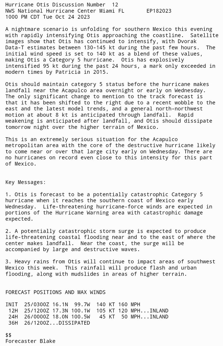
The National Hurricane Center is calling #Otis a "nightmare scenario.". "This is an extremely serious situation for the Acapulco metropolitan area. There are .no hurricanes on record even close to this intensity for this part .of Mexico.". Heavy words tonight from @EricBlake12
22
525
947
For only the third time on record (since 1851), 3 Atlantic tropical cyclones formed over 24 short hours (TD6, Emily, Franklin). The historic tropical cyclone outbreak this weekend was matched only by August 22, 1995, and August 15, 1893. #hurricanes

54
390
952


To put into perspective Ian's storm surge forecast from @NHC_Surge, here are monthly maximum water levels for two of our longest-running @NOAA tide gauges in the Tampa/St. Petersburg area. In over 50 years, we've not observed anything resembling the surge flooding predicted.
32
360
766
Who could've guessed Washington County, Maine — the easternmost point in the contiguous U.S. bordering Canada — would be in the @NWSNHC forecast cone more than any other county in the U.S. this hurricane season (162 hr)? No conefalls for South Florida or Louisiana so far in 2023.

19
194
754
We're going the wrong direction here. The Hurricane Helene storm surge forecasts from @NHC_Surge are now up to 20 feet into Florida's Big Bend. As someone who's issued these forecasts, I assure you the folks at NHC don't make these changes lightly. This is as big as it gets.

At 2 PM ET, @NHC_Surge bumped up the storm surge forecast for Hurricane Helene to as high as 18 FEET for the Florida Big Bend. This is rare territory for surge forecasts only issued in blockbuster hurricanes like Laura, Irma, and Ike. Take this water threat seriously. 🌊.
20
234
726
Remarkably, Hurricane Beryl remains a Category 4 tonight, which means it's been at Category 4 or 5 strength going on 84 hours. Only 11 other hurricanes in the satellite era (since 1966) have achieved such prolonged strength, with 10 of the 11 happening in September or October.


#Beryl has maintained Category 4 or 5 strength for more than 77 consecutive hours (from Sunday Jun 30, 2024, 11:35 AM AST – today Jul 3, 2024, 5:00PM AST). Wondering where this ranks in longevity of Cat 4+?
6
299
744
Since 2004, we haven't observed a tropical or subtropical storm in the Gulf with as wide of a tropical storm wind field as Alberto's. In fact, in 20 years, we haven't recorded a storm this deep in the tropics with such a large breadth of tropical storm winds. Impressive stuff.

23
185
735
Only 5 major (Category 3+) hurricanes have been recorded in the Atlantic before the first week of July. Beryl would be the sixth and earliest this far east in the tropical Atlantic. There's never been a Cat 4 or 5 hurricane observed prior to July 8th (Dennis in 2005).

19
213
725
This radar loop (via @markniss_) is over 25 hours long. To face this duration of Category 4/5 hurricane conditions is inconceivable. My thoughts this evening are with all those devastated by this terrible storm. #Dorian #Bahamas
14
316
600
20
394
616
From a veteran NHC Hurricane Specialist. I know it gets numbing from the storms of late, but this is a truly horrifying situation. #MariaPR


18
430
539
It's astonishing to see a forecast for a major (Category 3+) hurricane in June anywhere in the Atlantic, let alone this far east in the deep tropics. #Beryl organizing in a hurry over the warmest waters ever recorded for late June. Hurricane Watches up for much of the Windwards.


17
172
563
NOAA Hurricane Hunters flying Milton right now noting severe turbulence and hail (!!) entering through the rapidly intensifying hurricane's northwest eyewall. Pressures down now into the mid 940s. Bottom really falling out this morning.

12
149
566
8 weeks of persistent, record warm sea surface temperature anomalies stretching from the Canary Islands all the way to the Gulf of Mexico. Subtle changes since April have felt a little like rearranging the deck chairs on the Titanic. Not great no matter how you slice it.
51
168
547
The eye of still Cat 5 Hurricane #Irma now only 55 mi east-northeast of San Juan, Puerto Rico. A rare, impressive, and dangerous sight.
18
631
540
Of the 1,869 Atlantic storms recorded over the last 169 years, only 18 have recorded winds as strong or stronger than Hurricane #Dorian right now (175 mph). This is truly an historic storm.
32
366
502
For those wondering, yes, it's very unusual to get a Category 4 or 5 hurricane solidly over the Gulf this late in the hurricane season. If Milton's forecast verifies, it would be the first recorded Cat 4/5 Gulf hurricane this deep in the season since Michael in 2018.

28
114
523
The videos from Ian's back side are stunning. Mike's done more severe weather coverage than almost anyone on this planet. That's quite a statement.

We were in the eye wall of Cat. 4 #Hurricane #Ian for over 5 hours and the back side was the worst. I haven't experienced anything close to this in over 30 years @weatherchannel
6
113
454
20 years ago, this sunny day, high tide flooding wasn't a thing in Miami. Today, it happens a handful of times a year. By 2050 -- well within my lifetime -- @noaaocean predicts fair weather flooding as often as 50-60+ days/year (once/week). This is our future. #ClimateChange.

Saltwater bubbling up from Biscayne Bay onto Miami’s streets. Not a drop of rain for the past several days. #SaltLife . #KingTide #sealevelrise via @TropicMotion
31
289
474
To put Hurricane Lee's size into perspective, @NWSNHC estimates hurricane winds extend outward a remarkable 110 nm (127 miles) from its center. Since 2004, only four other hurricanes have had 64-kt wind radii as large — Ike (2008), Lorenzo (2019), Teddy (2020), and Sandy (2012)
19
180
467
Evacuation plans are predicated on storm surge, not rainfall flooding. Rain evacuations difficult to impossible due to forecast limitations.

This is one reason why Houston didn't evacuate. they've tried that, and the costs were enormous.
14
211
421

The rate of strengthening in Milton over the past 24 hours (90 mph increase in maximum winds in 24 hours) is about as fast as has ever been measured in the Atlantic, only bested by Felix in 2007 and Wilma in 2005 (100 mph and 105 mph intensity change over 24 hours, respectively)

4
163
449
As native New Orleanian, tropical meteorologist, and emergency manager who spends every day planning for the next big hurricane, my heart sinks when I see this. I don't know what tomorrow brings, but I do hope everyone finds shelter from the storm in the weary hours ahead.
7
89
427
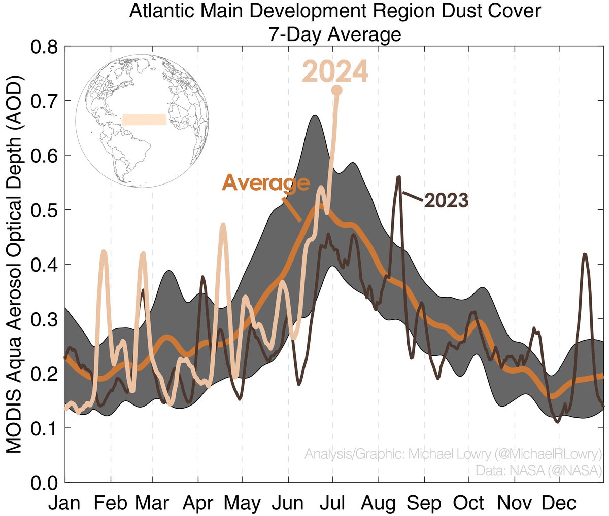
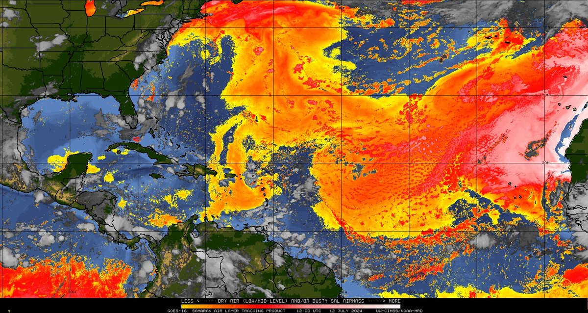
The dearth of Saharan dust this June across the tropical Atlantic is exceptional. Compare the extent to a typical June, last June, or June 2020 for a recent dusty example. Dustiness explains ~35% of SST variability in the summer so less dust generally means a toastier Atlantic.


13
125
433
Don't let anyone fool you. THE single biggest meteorological development today with #Florence is its now massive wind field. It's hard to overstate the significance of this. It will have major implications for the storm surge and damage potential. Do NOT let your guard down!
19
230
418
(1/) Something really remarkable is happening off the coast of #Peru and here's why you should care.
28
542
405
Despite all the Cat 5 chatter, this is the real headline in the hours ahead. An unthinkable #surge of saltwater will sweep ashore, causing widespread destruction across an incredible stretch of SE Texas and SW Louisiana -- the likes of which we haven't seen in a very long time.

Water levels are on the rise. Stations across Louisiana are currently reporting 1-3 foot storm surge. A 50 mph gust was recently recorded at the Freshwater Canal station

9
221
396
Here are the tracks and formation points of all hurricanes to hit the west coast of Florida since recordkeeping began (since 1851). Only three formed in the area near Milton — each October hurricanes, each way back in the late 1800s. All 3 struck near or north of Tampa.

15
105
414
The storm surge flooding at Cedar Key, Florida, is now above 9 feet. This blows aways the previous record set at the same gauge during Hurricane Idalia, and waters continue to rise. The expanse of storm surge flooding along Florida’s Gulf Coast tonight is truly mindblowing.

15
169
422
David has covered a lot of devastating storms, including Katrina. He's one of the best. Please keep him and all of our friends back in New Orleans in your thoughts as you go to bed tonight. They're going to need the help not just tomorrow, but in the long months ahead.
1
80
368
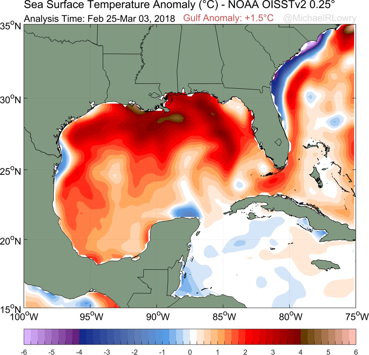
A weekly average Gulf of Mexico sea surface temperature anomaly greater +2.0°C (relative to 1971-2000 climatology) is exceptional -- in fact, it's the highest (absolute) anomaly of the satellite record for the Gulf. The warmth this Spring in the southeast U.S. is no coincidence!
23
269
391
When it comes to #hurricanes and tropical storms, there's #Florida and then there's everyone else.

27
233
394
Can't stress this enough. Don't do it. The forecast is for 5-8 feet of life-threatening storm surge into Tampa Bay. The water will return!

ALERT: Water surrounding Tampa Bay is very low due to the storm. It is dangerous to be walking out there.

25
270
359
18
277
392
The current outbreak of Saharan dust across the tropical Atlantic is the highest since at least early June 2022. Dust cover over the Atlantic in 2023 was the lowest since satellite records began in 2002. High dust can stifle hurricane formation and help cool down Atlantic waters.
18
102
383
Based on #Irma's satellite presentation and recent pressure estimates from Hurricane Hunters, it appears to be wasting no time reorganizing.
17
401
339

Only one hurricane has ever been recorded in June east of the Caribbean in the deep tropics – the first hurricane of 1933, still the most active hurricane season on record by Accumulated Cyclone Energy or ACE.

15
76
367
Just 20 years ago, there was some question whether mesovortices even existed. Now we're seeing them regularly in splendid detail on satellite. Science is truly amazing.

Mesovortices in Barbara, a powerful category 4 hurricane. Incredibly detailed satellite imagery.
6
96
361
181 mph at flight level (700 mb) on the @NOAA_HurrHunter pass just now on the northeast side of Hurricane #Beryl. We'll see what @NWSNHC says at 11 PM but these two pieces of evidence certainly suggest we now have a 160 mph Category 5 hurricane. (plot via @InfoVizard)


I’m going to bump this in the context of Hurricane #Beryl, which had max 0.5 km TDR winds of 155 kt and 2.0 km winds of 147 kt. Both are consistent with previous 140 kt TCs in the best track. But NHC makes final call of course.


6
108
363
The @53rdWRS Air Force Hurricane Hunters noting "extreme turbulence and frequent lightning" in their last pass through the northeast side of Hurricane Beryl. Both are indicators of a quickly strengthening storm. Not a ride for the faint of heart!

10
93
348

The western Caribbean can be a breeding ground for strong hurricanes in October. Waters typically peak this time of year and this week they're the warmest on record, topping 87°F (30.6°C) for the first time. Nothing in the models now, but a region to watch next month.
6
133
331


Best analogy for #GOESR satellite upgrade is like going from 2007 iPhone to current iPhone 6. 2017 weather in HD burst mode. Bigly stuff.
10
195
321
It's been fascinating to watch data roll in from an uncrewed hurricane hunting drone launched ~90 miles south of Helene shortly before 8 AM. It flew exceptionally low during its mission – hundreds of feet above the ocean – and crashed into the ocean about an hour ago as planned.
8
36
318

Last week the Gulf of Mexico recorded its warmest weekly anomaly on record at 1.5°C above the 1982-2011 average. That's some serious warmth.
30
260
304
Video beginning to trickle in of the damage in Acapulco in the wake of Category 5 Hurricane Otis. The high-rise damage is extreme along with the defronding of hearty palms. Really sobering to see this level of hurricane damage in such a densely populated urban corridor. #Mexico.

11
85
299
With this landfall statement, #Dorian's winds are estimated at an astounding 185 mph. Only 4 storms on record (since 1851) in the Atlantic have estimated winds of 185 mph or higher:. Allen (1980) - 190 mph.Wilma (2005) - 185 mph.Gilbert (1988) - 185 mph.1935 Labor Day - 185 mph

9
231
303
From 1981-2002, daily average water temps in the tropical Atlantic never cracked 83°F. We've done it in 9 of 15 years since, including 2017.

31
237
305
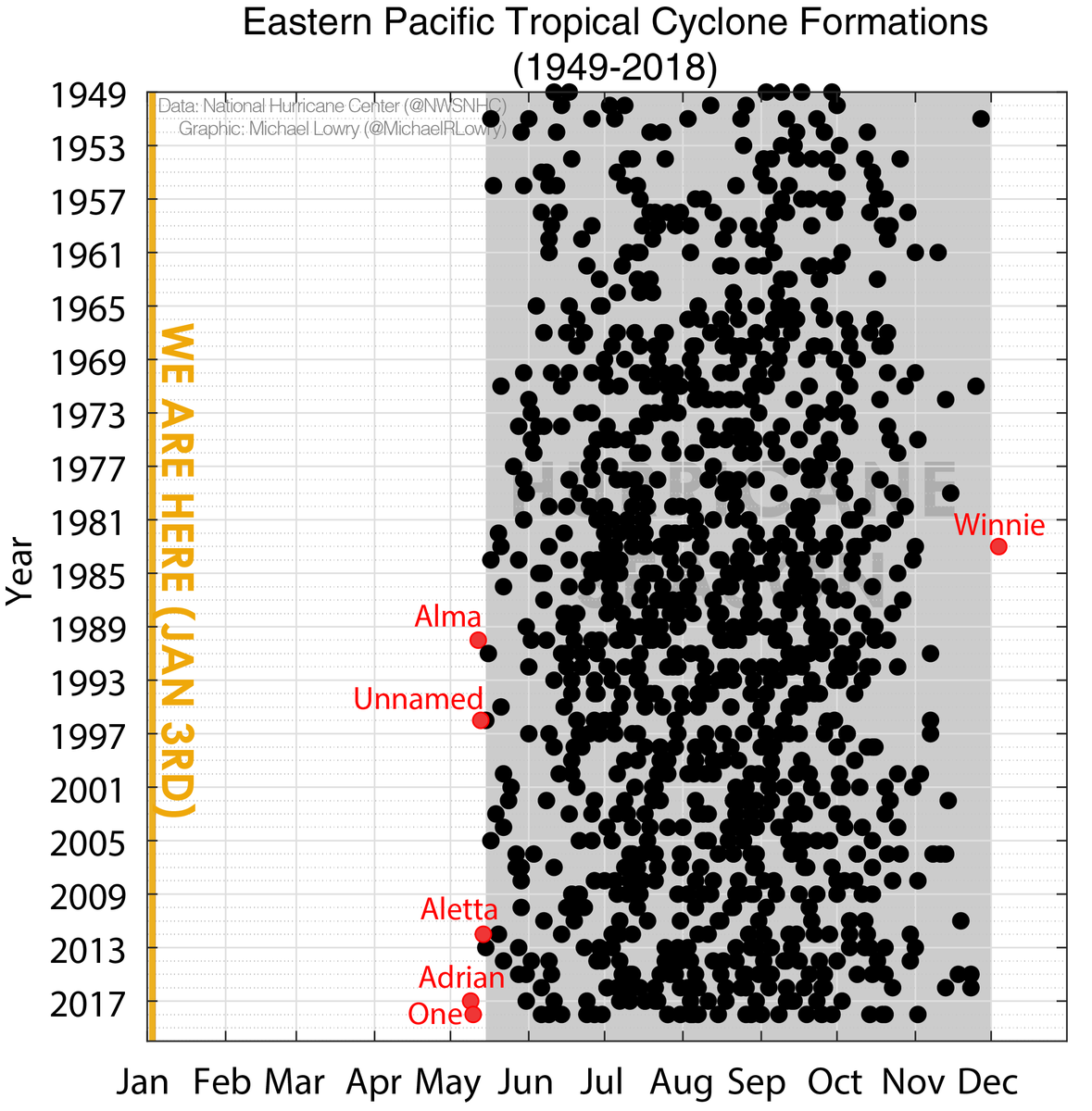
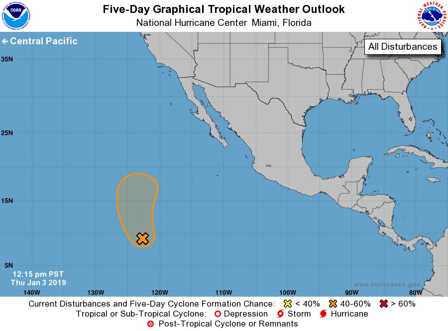
Out-of-season tropical formation is FAR more unusual in the eastern Pacific than in the Atlantic. No tropical system has ever been recorded prior to May in the eastern Pacific (since records began in 1949). @NHC_Pacific giving 50/50 odds of a January first.
8
179
297

Here are first formations by year for tropical cyclones in the eastern North Pacific (east of 140°W) since recordkeeping began in 1949. Tropical Depression One-E this morning is easily the earliest eastern Pacific tropical cyclone on record (by 2 weeks). #hurricanes #climatology
15
146
296
It's wild just how warm the western Caribbean is headed into November. Weekly sea surface temperatures are about as warm today as any previous time of year prior to 2023. And we're a full month and a half removed from the typical mid-September climatological peak. Astounding.

14
122
290
". storm totals may reach 50 inches. " This could be the most rainfall ever observed from a tropical cyclone in United States history.


9
427
279
For South Florida the time for hope has passed. A potentially catastrophic hurricane is headed your way. If ordered to leave, get out. #Irma

You can't wait for more model runs and just hope things change. You have to prepare for a hurricane. It's as simple as that.
19
198
259
No better way to celebrate #EarthDay than marrying your best friend and fellow meteorologist. I love you @WeatherKait! (photo: @andy_brophy)

31
9
292
The tropical North Atlantic has seen the second dustiest July so far since continuous satellite records began in 2002. Air quality has been especially poor off western Africa and over the Cabo Verde Islands. We've been talking a lot about dust, but it's certainly not unwarranted.


13
79
298

This would be a disastrous move should Congress approve such a proposal. Dismantling NOAA's research and development arm would shutter the Hurricane Research Division in Miami and undo any progress in hurricane forecasts, one of the great scientific advances of the past 50 years.

Need to sound the alarm on this one. As I understand it, this is from the "President's Budget Request", which often isn't really used that heavily by Congress (who actually controls funding). But this would essentially end all research and development within NOAA and NASA if.
6
113
318
Extra special to be able to show our amazing little girl one of our favorite spots for the first time. Couldn't have asked for a more beautiful weekend!

20
7
287
Sure looks like we'll be officially done with El Niño by the end of June or start of July. Then on to La Niña as hurricane season hits its stride. Here's the daily progression of the Niño 3.4 Region anomalies since the beginning of the year.
10
106
289
The experienced forecasters @NWSTallahassee not mincing words on #Idalia in today's area forecast discussion. If you live in Florida’s Big Bend from Apalachicola east - including inland areas like Tallahassee or Perry - don't sleep on this one. Within about 24 hours of the worst.


12
157
274
What an awful satellite picture to wake up to this morning. This is an extremely dangerous and potentially catastrophic #hurricane. For those in the path of #Laura, final preparations should be rushed to completion. My thoughts are with our friends in Louisiana and Texas today.
10
112
282
Still one of my favorite tropical climatology plots I've made. When shear is low and waters are warm, look for storms. #hurricanes

10
96
273
This is a remarkable satellite of Beryl scraping the southern shores of Jamaica with what appears to be increasing organization. Mountainous terrain may be giving convection a boost in the northern eyewall while tugging the center closer to the island. (loop via @TropicalTidbits)
11
84
269
With 155 mph winds, Hurricane #Ian teetering on becoming only the fifth Category 5 hurricane to strike the mainland U.S. on record (Cat 5 starts at 157 mph). Whether it does or doesn't is of no consequence or comfort for communities in the path. Catastrophic impacts regardless.


8
91
260
After 5 amazing hurricane seasons @weatherchannel I'll be taking a commercial break. THANK YOU for your trust and viewership over the years.


65
32
265
This last pass from Air Force hurricane hunters is about as high as I've ever seen flight level or surface wind estimates in a hurricane (Patricia notwithstanding). We now have a 160 mph Category 5 Milton, but this trace suggests it could certainly be even stronger than that.

1
81
263