Island Weather
@KJj12791128
Followers
132
Following
89
Media
70
Statuses
2,839
Puerto Rico and Virgin Islands Weather
United States Virgin Islands
Joined October 2022
Don't wanna be here?
Send us removal request.
Explore trending content on Musk Viewer
Luka
• 163579 Tweets
コロンブス
• 159176 Tweets
イーロン
• 130441 Tweets
#RejectFinanceBill2024
• 68511 Tweets
SNBT
• 61553 Tweets
Mrs. GREEN APPLE
• 47880 Tweets
ミセスのMV
• 35212 Tweets
カブさん
• 28580 Tweets
#れんれんおかえり
• 26107 Tweets
脊髄梗塞
• 23351 Tweets
公開停止
• 20682 Tweets
LINE Pay
• 20446 Tweets
下半身麻痺
• 20050 Tweets
規正法改正案
• 16996 Tweets
内閣支持16.4
• 16157 Tweets
Jandarma
• 14280 Tweets
ひろみちお兄さん
• 13626 Tweets
最低更新
• 13512 Tweets
郵便料金
• 11563 Tweets


Pinned Tweet

Caribbean be on the watch for the wave behind
#92L
. 2023 saying It's not over yet.


5
11
54
While everyone go in a frenzy because of Lee, there is currently another wave out there that is supposed to come off Africa around September 10. This has a chance to affect Caribbean. We will see. Euro, GFS and CMC are showing development.


6
9
55
@al3jandro_r3y
@latestinspace
Dang really? Bro I swear this year has to be the hottest years I experience.
1
0
51
EPS moving almost due west with the wave that's suppose to come africa next Tuesday 👀 Will continue watch over the week...
6
2
26
Latest GEFS has some ensemble members slamming in the islands. One run though

3
3
26
GFS finally picked on the wave that all other models has been showing. Also picked up on another one. GEFS is showing the weak goes west and strong goes north syndrome like the EPS. The trajectory would depend on the Bermuda high and when it develops.


2
3
23
GFS, ICON, EURO, and CMC all form the wave just right off the African coast. It would become future
#98L
sooner or later. All models expect this to miss the Caribbean, but we should watch it as it’s many days out and things will change.


3
0
20
Something to watch over next weekend for USVI and Puerto Rico. If an upcoming tropical wave and a upper-low were to align, then this will pose significant flooding and lightning across the islands. GFS and EURO shows an abundance of moisture Friday and beyond.


4
6
20
The Euro Esembles has increased at 06z. Waiting for the 12z ensembles and 18z GFS…

3
0
18


Euro, EPS, CMC, and ICON all of showing some sort of development of a wave that’s suppose to come off around September 1-2. Waiting for the GFS to pick up to see if this something to worry about…


6
1
16
@Meteouragans
Dude just ignore the comments. There’s people that actually like enjoy your content. You’re possibly saving million Caribbean lives during hurricane season. Cheer up and keep moving forward 👍
0
0
15
Euro 12z run is WAY more west and way more south then 00z run. First one is 12z, second one is 00z at around the same time frame.


1
1
13
@NecroFrozt
@Dexerto
She ain’t wrong though. Its good for bone health and heart longevity. But the thing is it has a common side effect. Death.
1
0
10
00z CMC and 00z GFS are hinting of possible development of a wave that may come off around the 18th. This wave will come off below 10 degrees north, which is quite low. If the mid-level ridge is strong enough, this could carry it west and maybe impact the islands 👀. Watching it


2
3
10
@AndyHazelton
I think both GFS and euro is craving to each other. GFS looks to be going north while Euro looks to be going south. I going to assume it’s starting to agreement somewhere near or over northern Caribbean
1
0
9
@HexidonOfficial
@TateTheTalisman
Man if I ain’t a man for drinking hot chocolate then so be it.
0
0
9
@AllLevelsBoxing
@MoSyed110
@KSI
Did you really think that KSI was going to outbox tommy? Look what happened to Jake. KSI know what he had to do to win was to fight in the inside.
1
0
8
@reid_lt
How is it rapidly dwindling… a week out and claiming this isn’t the best idea. And GFS shows that just because it doesn’t make landfall, it’s big enough to cause some significant impacts.
1
0
10
@CycloforumsPR
@TropicalTidbits
I ain't Levi, but my middle name starts with a L so I'm going to answer. I think that's highly unlikely.
0
0
10
I wonder if it's possible for Rina to rotate around Phillippe so much that Rina slams into islands.... Probably 1 in a million chance of happening
4
1
9
2
0
6
GFS, CMC, and ICON is all developing the wave that supposed to come off around September 10. Euro backed off drastically and doesn’t even form anything. GFS spawns a weak system that goes into the Caribbean then head north and become a strong hurricane. I’m going to track changes


3
2
9
@AlanSevere
Honestly GFS is good at picking up on moisture on these waves. GFS says "another one" behind Sean and future
#94L
0
0
9

The islands is under a drought. Schools are closing early due to no AC which makes students and teachers go out and protest, houses cisterns are drying up, people catching illnesses and farmers are suffering. This is probably the first time I wish for a tropical disturbance..


3
0
8
06z Euro Ensembles not that much changes from 00z. Maybe a little stronger than previous run:

1
0
8
@CycloforumsPR
Is NHC sure that's Where the center is lol. I swear it look like it was moving west this whole time.
0
0
7
Here we go boys and gal. GFS, EURO, ICON, and CMC all form 1-2 tropical systems in the basin. GFS and EURO form one tropical system which puts it on a path towards or near the Caribbean, while CMC and ICON forms two systems. NHC is currently tracking this wave. Keep watching 👀


1
1
7
EVERYONE STAY CALM. It’s to late to say potential 95L will become anything major. But remain 👀 for any potential changes. ICON, GFS and EURO had trended more south putting a track closer the Lesser Antilles. United States, just watch. Here’s EPS and GFS latest:


1
1
7
0
0
7
Its another day tracking the wave off africa and GEFS still don't know where in the world it wants to take it. We can't tell due to it downticking in intensity once again 💀 On the first image, I've notice that GEFS is showing two different signals I wonder if it's two systems...


1
1
7
GFS, ICON, and CMC continue to show development of a tropical wave that’s suppose to come off late weekend or early week. CMC shows a near cat 2 affecting Northern Caribbean. Euro shows a weak tropical wave while GFS and ICON shows it curving out to see. Keep watching for changes


1
2
7
@AlanSevere
@reid_lt
@justbooket
@AndyHazelton
@DaDaBuh
I think 2023 is just telling us to prepare for what is to come in 2024
2
0
7
@TWAPuertoRico
Since it's due to how fast the system moves, we should see tomorrow how fast west it had traveled
1
0
6


Latest Euro Spaghetti ensembles… It looks like the path is starting to come in agreement

3
0
6
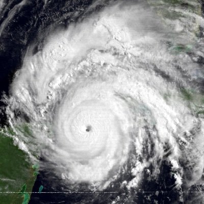
Meanwhile, Lee is about to be a hurricane. Northern Caribbean, Bermuda, East coast United States, and Canada watch this closely…

0
1
6
@CraigSetzer
Looks like Virgin Islands having some sort of tropical storm conditions. 50 miles gust reported south of St Croix.
0
0
5
1
1
4
1
0
1
My Predictions for this 2023 hurricane season:
15 named storms
6 hurricanes
3 major
I will pin this tweet to see if I’m correct or close.
1
2
5
@AlanSevere
@justbooket
We are at a loop at this point. Wave comes off, models go crazy, everyone hypes it up, wave gets sheared, wave underperformed, everyone goes quiet, repeat...
1
0
5
@CraigSetzer
I was confused why people are sticking with the hurricane models and using it as forecasts lol. Best bet is to listen what NHC says
1
0
5
@FloridaTropics1
@juliannn_67
Why in the world would they focus on Franklin? At least
#93L
is going to affect land.
2
0
4

@GFoster1982
@AlanSevere
@BenCptcatz
Nah I swear they want Cat 5’s with massive destruction to track because they bored.
2
0
5
@AlanSevere
I wonder if a tropical storm warning would be instantly issued. I wonder what islands would be on the warning?
1
2
5
@AlanSevere
El Niño failed us. August spawn in 6 systems including two major hurricanes in almost of span of a week. We haven’t even reach the peak of September 10 yet. And I think the first and last week of September should be favorable for development of systems.
2
0
5
@AndyHazelton
Ain’t no way I’m listening to the GFS for the amount of mistakes it’s pull this year.
0
0
5

@AndyHazelton
Is it possible get like a weak depression or storm in northern Caribbean because I miss my thunderstorm and rain. Its boiling hot and dry like chips here and I prefer rainy weather. Haven't got a good lasting storm since last year...
2
0
5
@JhnAdmz
@zarabeaune
@TateTheTalisman
Dude that still doesn’t make sense. You are like the people who call China communist even when they are literally capitalist.
5
0
2
As all models continue to show development of the wave that currently is being track by NHC that may develop in a depression on the weekend, the wave on Euro’s 00z has dropped significantly souther than yesterday Euro 12z. First image is yesterday 12z, second image is today 00z:


0
1
4
@AndyHazelton
If something does pop up let's hope something caps development like the shear that basically messed up both Lee's and Nigel's structure.
1
0
4