
D. mojavensis 🇺🇲 🇺🇦
@Dmojavensis
Followers
3,060
Following
450
Media
2,523
Statuses
17,130
Fictional character - explores the world through (sometimes dark) humor. P.S. pls treat tweets from this account as personal notes, which happen to be public.
Mojave desert, California
Joined February 2016
Don't wanna be here?
Send us removal request.
Explore trending content on Musk Viewer
NuNew 3rd Showcase
• 201030 Tweets
Illa
• 80696 Tweets
#Number_i_ビアボール60秒CM
• 72386 Tweets
Puigdemont
• 69507 Tweets
$GME
• 48062 Tweets
Michael Cohen
• 42381 Tweets
Good Monday
• 38908 Tweets
LINEスタンプ
• 32164 Tweets
STOP MISTREATING NEWJEANS
• 25839 Tweets
LINEの新機能
• 22611 Tweets
ALWAYS BESIDE GULF
• 19694 Tweets
FOURTH CANDIDATE 5M
• 19558 Tweets
最高の仲間
• 18791 Tweets
#アンメット
• 18301 Tweets
GameStop
• 17951 Tweets
Square Enix
• 17158 Tweets
サマーウォーズ
• 15501 Tweets
GET WELL SOON GYUVIN
• 14095 Tweets
Deco
• 13092 Tweets
#櫻坂46_承認欲求
• 11173 Tweets
Roaring Kitty
• 10628 Tweets
#あなたを犬の種類で例えると診断
• 10205 Tweets


Pinned Tweet

From now on all (geo)locations published on this channel will be hashtagged
#Dmojavensis_location
(previously determined locations, currently untagged, will be added to this hashtag over time).
1
0
15
These two recruitment videos pretty much sum up the evolution of UA Armed Forces over the last 9 years: from forgotten / neglected / disrespected (prior to RU invasion in 2014) to a determined formidable force now.
- ~20 years ago (attached)
- now (referenced tweet)

The time has come to take back what belongs to us.
4K
15K
78K
41
212
2K
@washingtonpost
That bridge **is** within UA borders - it's west of Tuzla island which is already in Ukraine. Come on guys, you can do better with geography than that.
5
22
2K
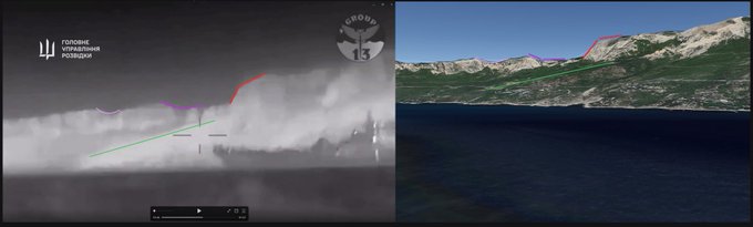
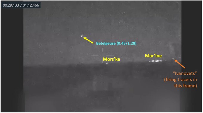
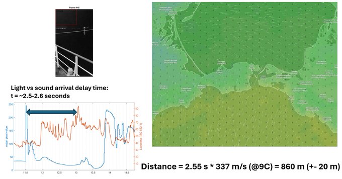
On early morning 02 FEB 2024 RU corvette “Ivanovets” was attacked and sunk by UA USVs ().
Based on star positions seen in the extended video () we time and geolocate it:
Time ~ 03:44 (UTC+3)
POV ~ 45.3106, 32.8153
@GeoConfirmed
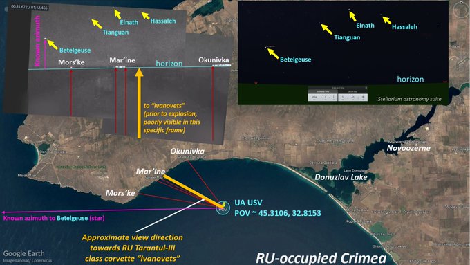

#працюєГУР
🔥 «Івановєц» на дні ― внаслідок спецоперації ГУР МО знищено ракетний корабель ворога
🔗
71
153
1K
69
242
1K
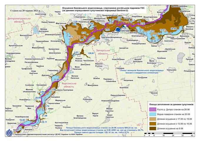
Kakhovka reservoir is drying up: Sentinel-2 data processed by Ukrainian Hydrometeorological Institute
(light blue - water remaining on June 20, purple - Dnipro river bed).
13
140
561
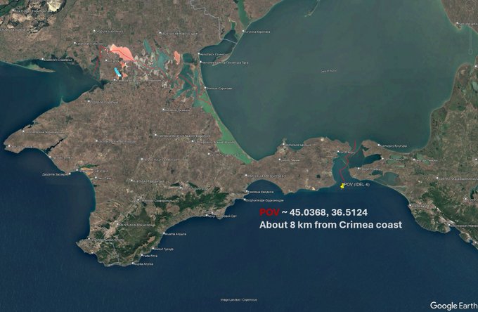
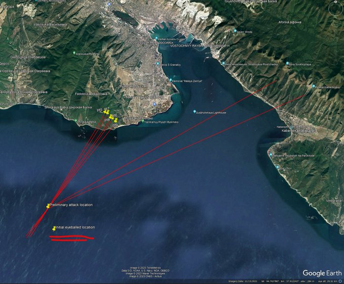
RU patrol ship Sergei Kotov was attacked by UA USVs on 5 MAR 2024.
Together w/
@COUPSURE
,
@kromark
,
@LoLManya
we find the likely attack location based on AIS coordinates of nearby vessels & sat. imagery:
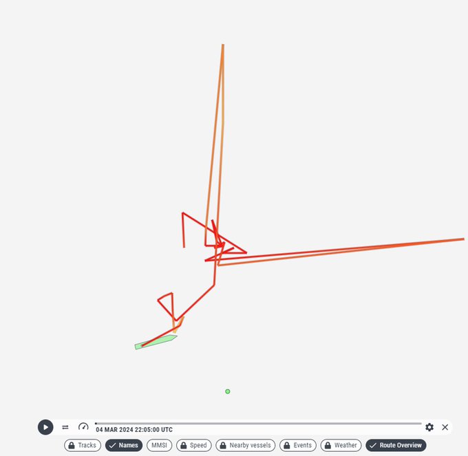
POV ~ 45.0368, 36.5124
@GeoConfirmed
🧵👇
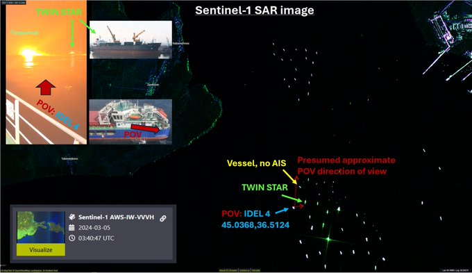

/1. This night, Russian Project 22160 patrol ship “Sergey Kotov” was successfully attacked by Ukrainian naval kamikaze drones near Feodosia, Crimea. According to Russian sources “the ship is dead”
82
433
4K
18
89
564
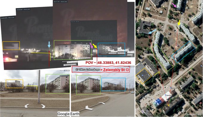
Reported UAV attack against RU Morozovsk air base (Rostov Oblast), early morning 5 APR 2024.
We use light/sound time of arrival to map explosions.
NOTE: multiple explosions are recorded on video => light/sound peak correspondence is PRESUMED sequential (not guaranteed true!).🧵
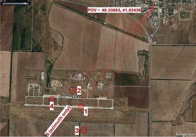
Air defense working and explosions seen in direction of Morozovsk Air Base (Rostov Oblast, RU ), early morning 5 APR 2024.
POV ~ 48.33883, 41.82436
@GeoConfirmed
Moment of humor: the street seen in the video is *Zelenskiy Street*.
1
7
67
8
98
549
@arestovych
Військовослужбовців з Маріуполя вже дістали, перш ніж хіхікати і самолюбуватися в соцмережах?
10
11
489
@UAWeapons
@blueboy1969
What makes you sure it was a Ukrainian surface to air S-300, not Russian or Bielorussian surface-to-surface S-300 launched from Belarus against Dobrotvirska TPP or the major UA-Poland powerline that goes right where the impact has happened?
27
20
377
4
12
323
In this thread we will do a deep dive on RU construction projects in occupied south-eastern Ukraine:
- new railway
- existing highway renovation
- rebuilt natural gas pipeline
- new water pipeline
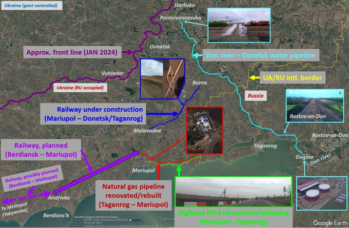
8
78
338
On 14 FEB 2024 RU ship Caesar Kunikov was sunk by UA USVs off Crimea coast.
While *qualitative* location was immediately determined (), *precise* location wasn't.
Here, we computationally determine the precise location of the USV and the ship.
Thread🧵👇
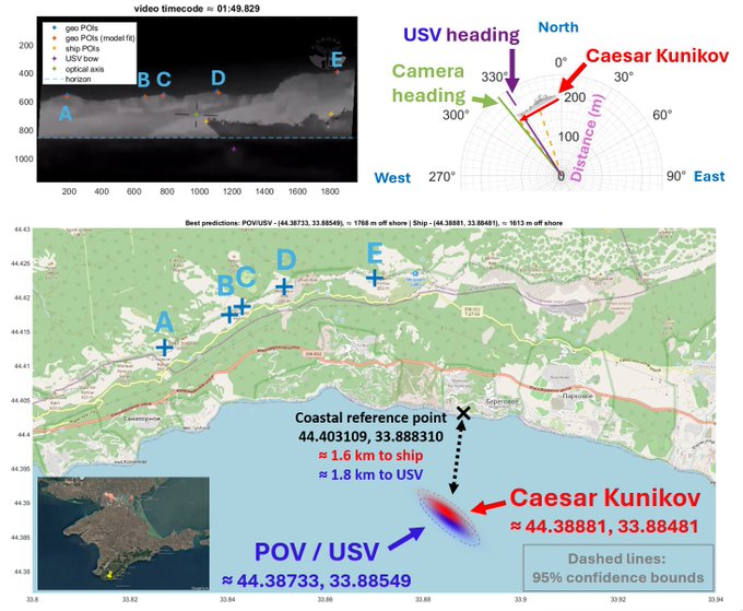

USV hits on russian Ropucha Class, likely location south of Parkove, Crimea
around ~44.3747, 33.8822
@GeoConfirmed
@UAControlMap
6
40
274
10
51
308
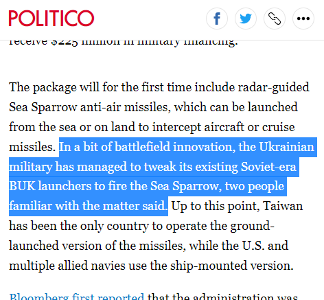
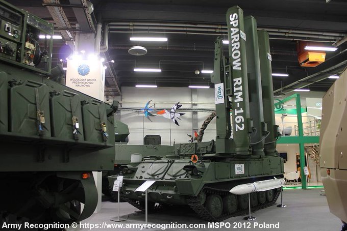
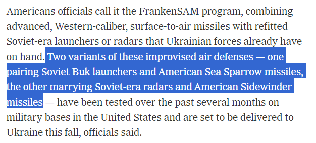
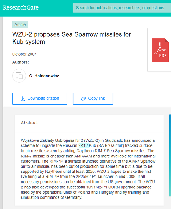
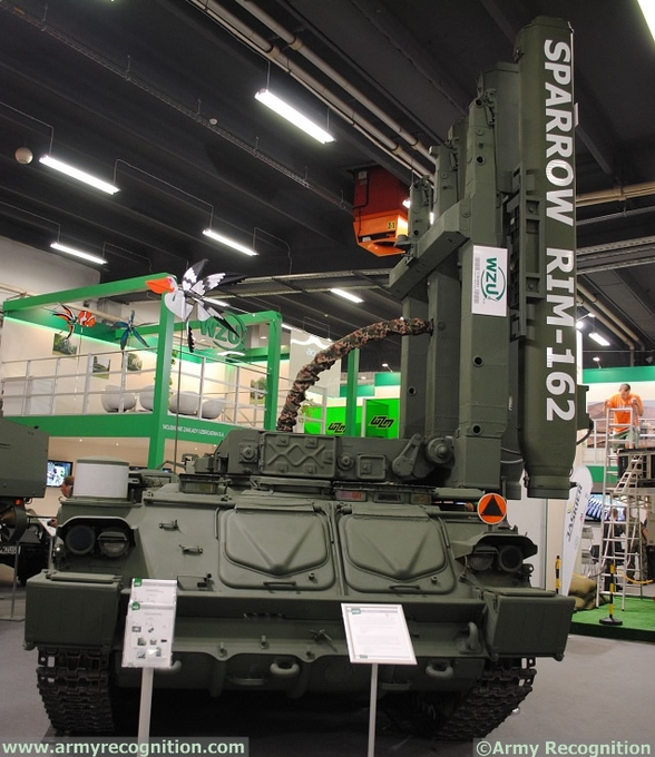
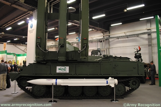
About Sea Sparrow surface-air missile adaptation to UA Buk-M1 SAM systems that Politico has reported yesterday ().
It's not as surprising as it may seem at first.
In fact, Raytheon (Sea Sparrow manufacturer) and Polish WZU-2 worked on this in 2007+
->
6
46
256
@Maks_NAFO_FELLA
Thought it was someone's online joke, but seems they actually did it -- "naughty-naughty" ( ) ! 😉
4
21
240
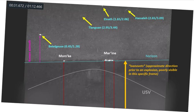
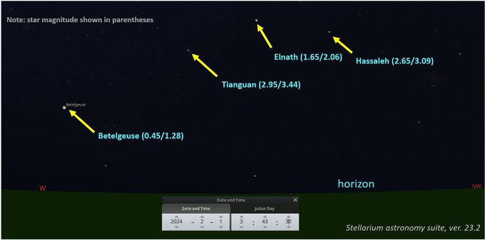
The specific video frame used to determine the time and USV POV () as well as the USV camera parameters (focal length – to be used for angle measurement in other frames of the video).
We clearly identified four stars in this video.
1
11
238

4
0
229
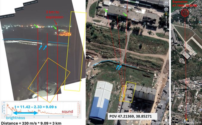
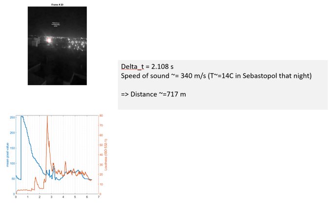
An apparent explosion next to Beriev Aircraft Company in Taganrog reported early morning 9 MAR 2024.
Explosion location inferred from the light/sound arrival difference.
POV ~ 47.21369, 38.85271
Explosion ~ 47.1909, 38.8736
@GeoConfirmed
vid src:
11
49
224
The identified stars were: Betelgeuse, Tianguan, Elnath, and Hassaleh.
Here is the night sky prediction for the calculated time and USV POV location (we used for astronomy computations).
4
7
208
Thanks to excellent work of
@olga_pp98
monitoring RU marine comms, turns out russians are performing "recovery of debris" (possibly of the downed RQ-9). Based on the recording it seems non-RU aviation might be in the air monitoring the area as well (in addition to RU Be-12 a/c).

Recently as per USCENTCOM in Europe report Sukhoi Su-27 ran into the MQ-9 Reaper UAV in neutral waters of Black sea.
The Russian Navy Black sea fleet had rescue operation using the HF communications on 8585 kHz USB
Recordings:
1/2
33
111
288
10
79
199
@sentdefender
What are you on about?
These are a) not accredited journalists but press/propaganda officers of the occupational force, b) they almost certainly neither were UA accredited for journalism nor had UA entry visa in their passport (yes, RU citizens require a visa to visit UA).
2
3
193
POV and time determination:
- known 2+ star positions => POV camera focal length (f)
- horizon position => camera pitch/roll
- camera f/pitch/roll => get star elevations => get time from elevation table
- known star azimuths => absolute camera heading => get all POI headings
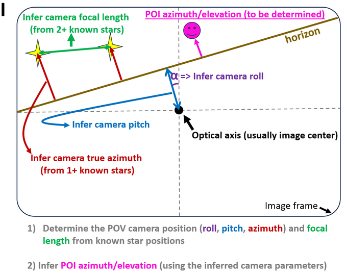
3
10
206
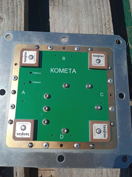
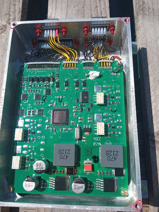
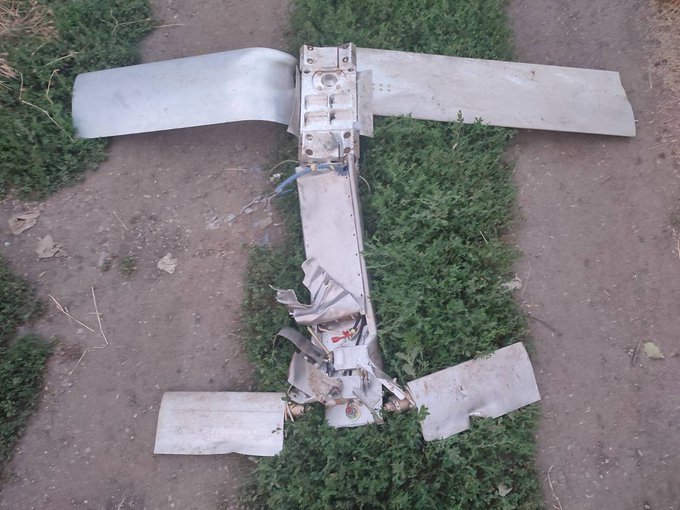
Based on these photos RU UMPK "JDAM-ERski" gliding bomb kit seems undoubtedly GNSS guided (uses Irish Taoglas GNSS antennas ).
Also, as expected, seems it's controlled by two independently actuated all-moving elevators (controls pitch and roll, no yaw).


4
58
200
Details on FrankenSAM (air defenses) for UA per today's NYT article ():
- at least two systems:
* Buk launchers + RIM-7 Sea Sparrow missiles
* "Soviet-era" radars + AIM-9M Sidewinder air-to-air missiles
(more down the thread) ->
6
51
192
@krides
He (єнот полоскун) will help them wash clothes, because they couldn't steal a washing machine? 😉

4
9
191
Strong explosion (at possible RU SAM site, see below) near RU-occupied Yevpatoria, Crimea on early morning 14 SEP 2023.
POV ~ 45.158573, 33.286427
Explosion: ~ 45.176622, 33.242427
#Dmojavensis_location
@GeoConfirmed
src:
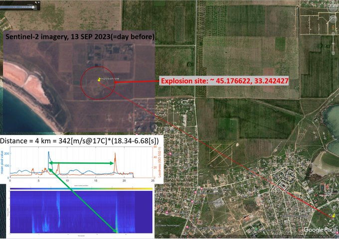

Additional footage of a secondary strike/explosion in Russian-occupied Yevpatoriya
28
345
3K
5
25
190
@jmvasquez1974
That's right. Both Stalin and Hitler attacked Poland in 1939. Fascism was eventually destroyed in Germany, but its close cousin remained in the USSR and got resurrected in Putin's Russia.
1
12
182
@DetectorMedia
⚠️Маніпуляція:
@DetectorMedia
не приводить посилань на доказову базу:
1) що запит про ціноутворення є "маніпуляцією" а не запитом на прозорість
2) що походження запитань - в росії
3) про походження коефіцієнта 2.5х крім загальних слів
✅запити на фінансову прозорість - нормально
2
14
178
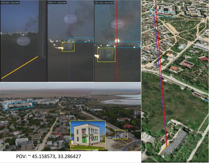
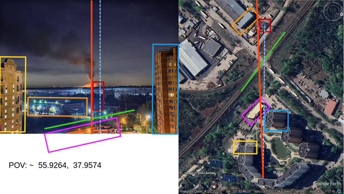
A fire seen from Shchyolkovo, Moscow Oblast.
Contrary to what's written in the quoted tweet below this fire is not at Chkalovsky airfield.
POV: ~ 55.9264, 37.9574
#Dmojavensis_location
@GeoConfirmed
src:
8
34
181
@UAWeapons
@blueboy1969
It's important to separate evidence and hypotheses/assumptions/priors in order to be scientific. => the evidence may be consistent that the part on the photo is an S-300 part, but specific evidence is required to objectively determine the origin of this debris.
4
2
168
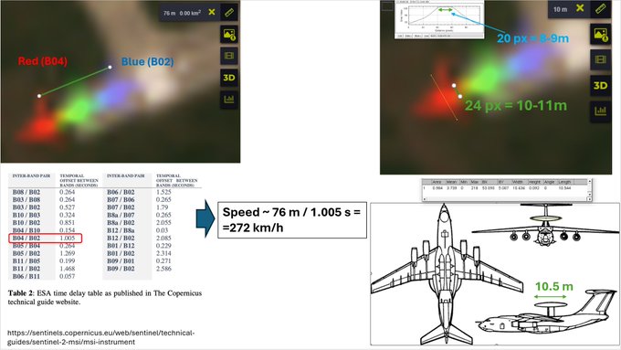
Possible A-50 takeoff from Sochi (URSS) seen in Sentinel-2 imagery (2024-02-29, 08:27 UTC).
Shape/size/take off speed are consistent with A-50. Speed was estimated from known time delay between Sent-2 red/blue channels.
43.4392, 39.9249
@GeoConfirmed
🔽
8
36
178
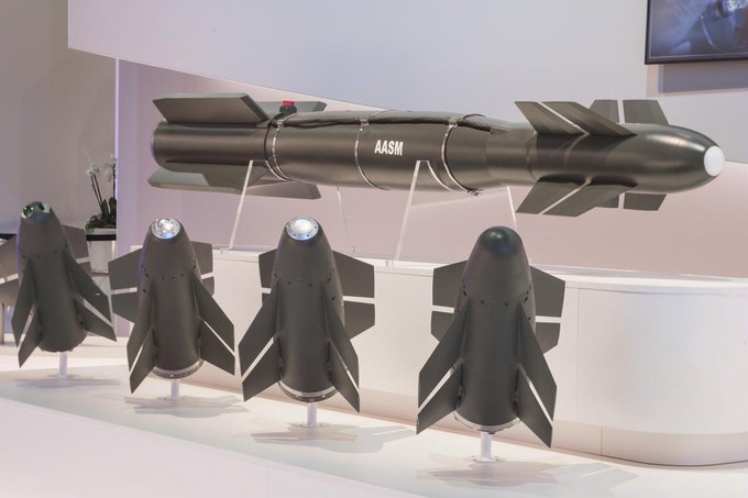
Le Monde reports that on Tuesday French President Emanuel Macron announced sending "several hundred" AASM HAMMER powered gliding bombs () to Ukraine (in addition to 40 SCALP missiles).
Wonder what the launch platform will be..
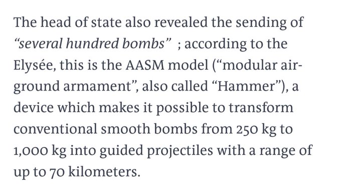

Według dziennika Le Monde obiecane Ukrainie przez prezydenta Macrona "setki bomb" będą wyposażone we francuskie moduły kierowania AASM Hammer, które umożliwiają przekształcenie konwencjonalnych bomb o masie od 250 kg do 1000 kg w pociski kierowane o zasięgu do 70 kilometrów.…
1
10
91
10
30
178
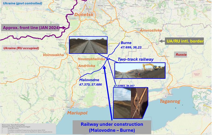
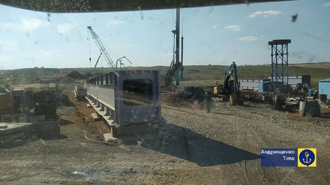
Brief update (with geolocations) on Malovodne-Burne (Mariupol) rail line construction by RU occupational forces.
Based on geolocated media footage we confirm that in Novomykhailivka area there will be a railroad segment (of undetermined length) with 2 parallel tracks.
🧵⬇️
7
54
166
@grntmedia
В нього ще така цитата є: «Немає нічого більш втомливого, ніж бути присутнім при тому, як людина демонструє свій розум. Особливо, якщо розуму немає»
0
4
171
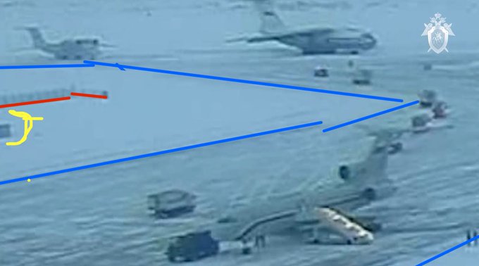
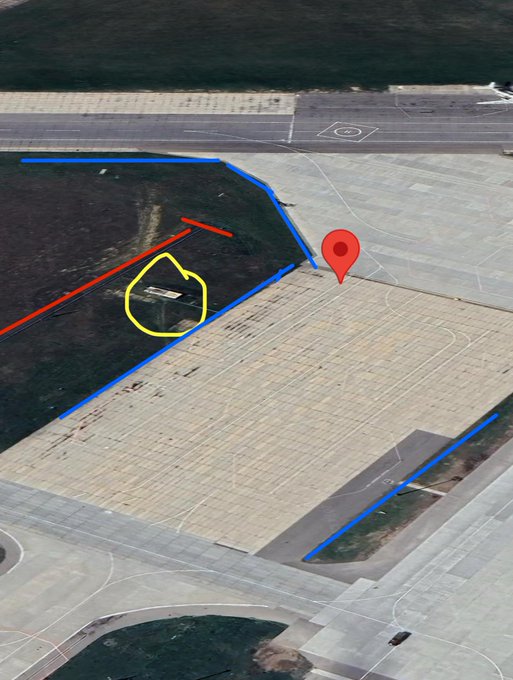
RU govt () published an undated video purportedly showing UA PoWs boarded onto an IL-76 variant aircraft.
Likely location: Chkalovo military airfield, Moscow.
POV ~ 55.89166, 38.05323
Original geo:
@COUPSURE
@GeoConfirmed
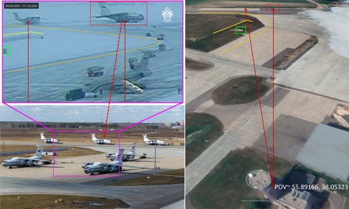

I believe this undated video was filmed at Chkalovsky airport in Moscow.
This geolocation is more a guess than a certainty. Open to suggestions.
(55.8924156, 38.0426328)
@GeoConfirmed
21
80
522
9
44
173
Some highlights from comments:
- the old UA ad may be from 2008, so 15 years old. The music ("Black BMW") is from at least 2004 in any case.
- Austrian Armed Forces had almost exactly the same ad in 2010 (even includes gun stroking 😂). Unbelievable

4
6
164
Fire (planned or accidental) was reported tonight (07 FEB 2024) at Votkinsk Machine Building Plant test site.
Based on triangulation of available imagery we estimate its location within the test site:
rocket engine testing facility ~ 56.9386, 53.4142
@GeoConfirmed
🧵
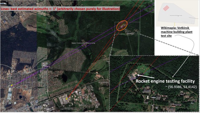

⚡️It is reported that the explosion near the testing ground of the 🇷🇺 Votkinsk Military Plant
36
137
1K
10
48
162
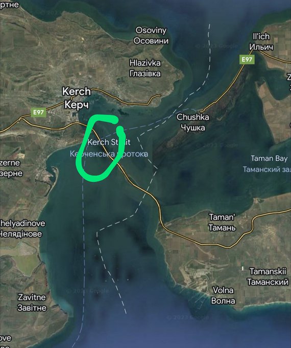
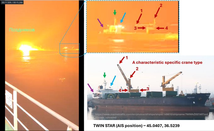
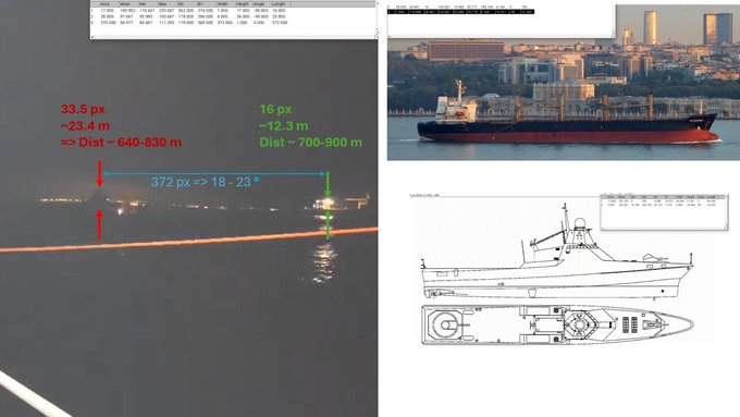
First, we noticed a nearby cargo vessel with a peculiar shape of cranes. We looked through the vessels near Kerch Strait w/ AIS on and found a likely candidate: TWIN STAR ()
2
4
159
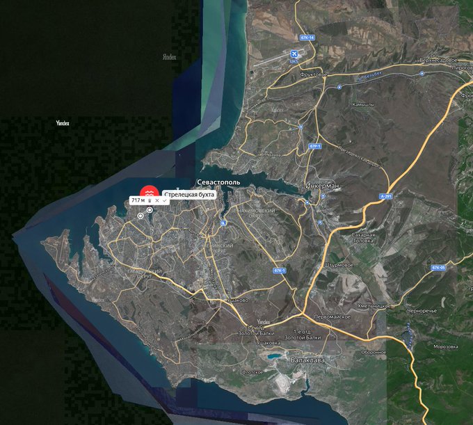
Sebastopol (RU occupied Crimea) attack last night (23 MAR 2024).
Lots of information in this video:
Three strikes ~ 44.58611, 33.51192
Refined POV ~ 44.58538, 33.5202
@GeoConfirmed
Two more apparent explosions visible (azimuths ~270.8 and 12.4°)
⬇️🧵
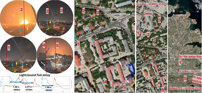

Ракетна атака на Севастополь.
Sevastopol, Crimea, Ukraine
Pov: 44.585461, 33.520612
@GeoConfirmed
@UAControlMap
9
37
225
5
44
156
@sentdefender
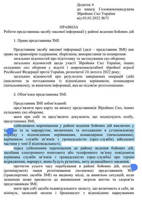
Additionally, if you are a journalist in the military operations areas according to the decree 73 of the commander of UAF you have to provide you routes in writing to AFU (addendum 4, paragraph 2).
Something tells us they did not provide their route details to the AFU.
0
3
138
@AndrewPerpetua
Not be just second Poland, but the spiritual successor of the original Kyivan Rus' (obviously in UA borders) -- the most dreaded (by Russia) outcome.
3
3
148
@am_polak
@christogrozev
They probably mean east bank of Oskil river (Kup'yans'k is on both banks, railway hub is on the east side, and it's likely RU tried to not let UA forces stay there)
3
0
146
POV and time determination (cont-d):
- map POI headings => get the POV location by triangulation
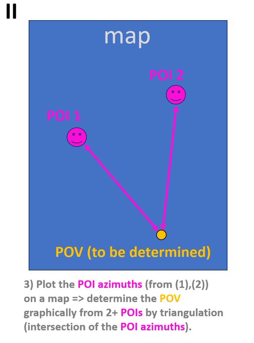
1
5
151
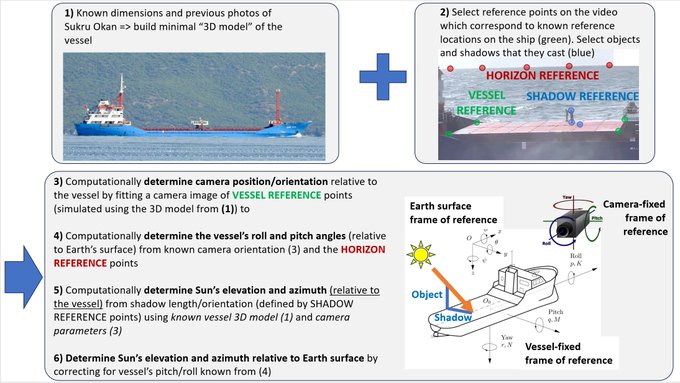
For this geolocation we used some of the methodology previously developed for “Sukru Okan” geolocation:
To geolocate the videos, we determined:
1) the Solar elevation and azimuth angles (relative to Sukru Okan’s heading), corrected for the ship’s angular movement (roll, pitch);
2) the time and approximate vessel position from Solar position tables and the known AIS track.
1
2
27
1
8
151
On 13 AUG 2023 RU military boarded Sukru Okan bulker ship in Black Sea close to Turkish coast.
In this thread we computationally determine where and when this likely happened by analysis of publicly available videos combined with AIS vessel tracking data.
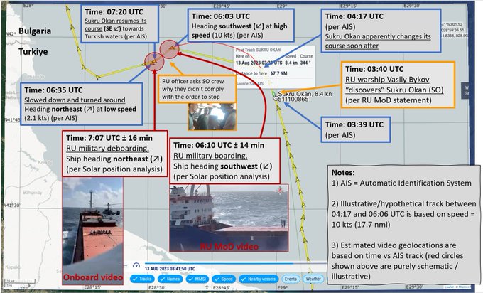

Russian navy claims to have borded a cargo ship by force, just 40 km outside Turkish territorial waters.
The ship, Sukru Okan, had left Bosporus hours earlier and was heading for Izmail, Ukraine. Ship is now in Bulgarian territorial waters.
8
60
141
2
34
148
Forgot to add one more (supplemental) slide: historical “light pollution” in the area of interest based on .
This matches and thus further supports the lights pattern that we see in the HUR video.
4
6
149
Approximate direction towards the vessel can be estimated from this frame:
1
5
149
Train reportedly w/ fuel was set on fire at a single track section of Severomuyskiy bypass (BAM railway, Buryatia, RU).
Geolocation🧵w/
@kromark
,
@Bazinga00264477
,
@blinzka
.
Damage near Pole
#145
(video👇): ~ 56.188858, 113.469166
Photo POV: ~ 56.1834, 113.47066
Details🧵->
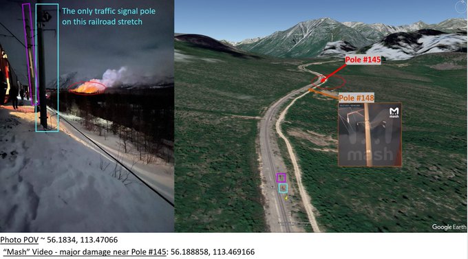

Video of the same scene from Russian TG channel: . Ukrainian claim about the 'Devil's bridge' as the place where the explosion happened (it's used as a spare route to bypass the tunnel damaged after the 1st explosion):
3
26
201
4
28
144
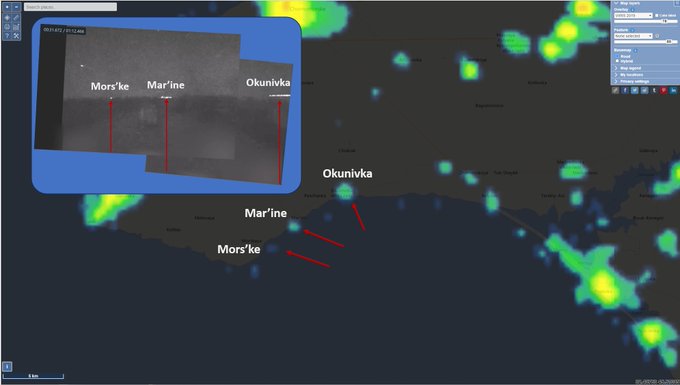
Heading/azimuth towards Okunivka was determined from this frame:
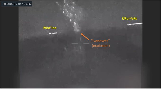
1
5
148
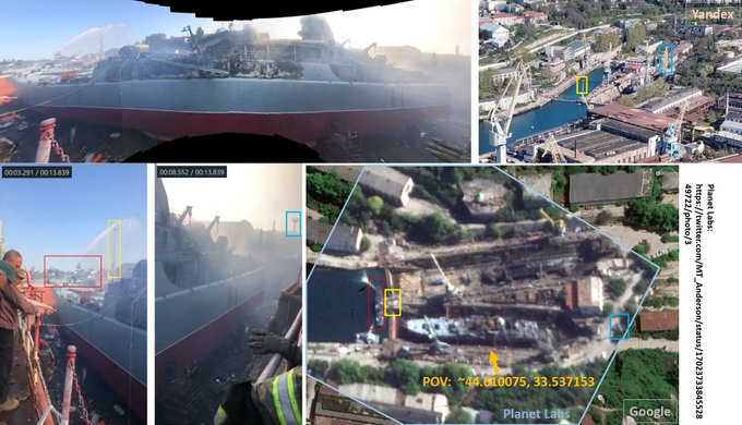
By request, here's the full-size (auto-stitched) panorama of the badly damaged RU Ropucha-class landing ship (Minsk):
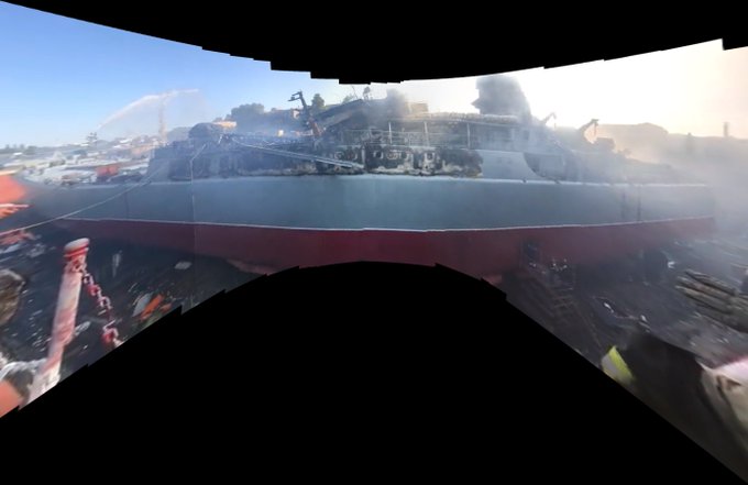
Panoramic video of the damage to RU Ropucha-class landing ship Minsk that was badly damaged by a missile strike in RU-occupied Sebasotpol, Crimea on 13 SEP 2023.
POV: ~44.610075, 33.537153
#Dmojavensis_location
@GeoConfirmed
Sat imagery:
@MT_Anderson
3
3
24
10
27
135
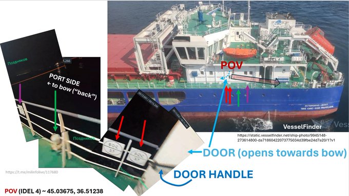
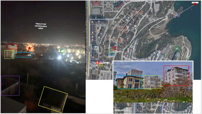
We then identified a nearby vessel IDEL 4 as the clear POV of the video (~ 45.03675, 36.51238).
We identified matching railing, signage, and the door that can be seen in the video. The video was filmed from the port side looking towards IDEL 4 stern.
2
4
143
..and for “Olenegorskiy Gornyak” geolocation (methodology itself has been unpublished until now):
Update on 4 AUG 2023 location of USV attack of RU "Olenegorskiy Gornyak" Ropucha class vessel: here is a 'quick-and-dirty' geolocation based on star/planet location using computational photography approach. Strict statistical inference coming soon too.
0
3
15
2
6
143
P.S. As always, please do let me know if you find any errors or have useful critique or questions!
..and thank you to have read this far down the thread 😋
3
2
136
Putin's visit to RU-occupied Kherson region (possibly) reveals RU south command headquarters location 👀👀
POV: 46.00514, 34.84522
#Dmojavensis_location
@GeoConfirmed
@EjShahid
@auditor_ya
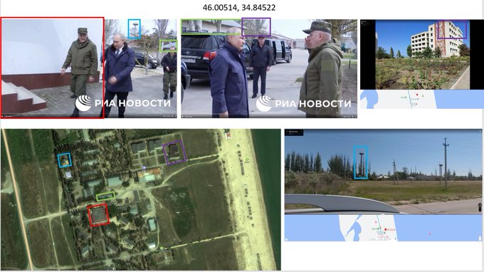
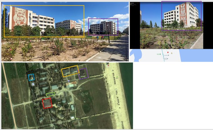
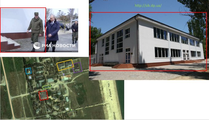
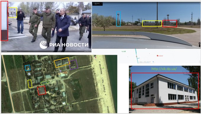

Video footage now of Putin’s illegal visit to invasion forces in occupied Ukraine. The Kremlin claims Putin’s visit was not planned in advance and totally spontaneous, according to RIA. He visited Kherson region as well as Luhansk.
10
17
59
6
35
132
Also, everything changed in 2014, and there are a lot of emotional recruitment and social ad videos supporting UA Armed forces from after 2014:

2
8
127
P.S. (
#2
): if anyone is interested in detailed math used for the computational geolocation above let me know. If there is enough interest I may do a separate technical write up on that.
8
2
132
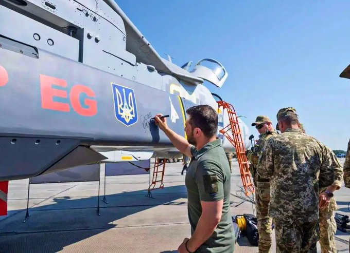
"High-level international negotiations are continuing between AU, UA, and the US over the fate of the decommissioned fighter aircraft, in what could become this country's largest-ever single transfer of military equipment to a foreign power."

6
24
122
Finally, all calculations were done assuming ideal pinhole camera model (i.e. neglecting any real-life aberrations). For the angle of view of the camera in this video however distortion aberrations could be expected to be small. Also the stars fit well.

2
6
129
Errata (argh!):
Of course I made a typo🥵in the text of the first message in this thread - the date is **01 FEB 2024**
2
4
129
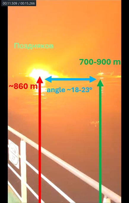
We also estimated how far the distance from the POV/IDEL 4 to the Sergei Kotov being attacked based on the delay between the light/sound from the explosion:
Distance ~ 860 +- 20 m.
1
3
126
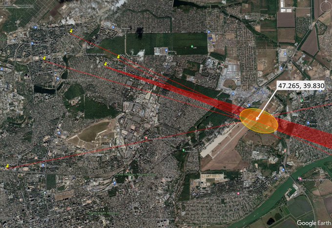
Significant RU air defense activity was reported in Rostov-on-Don (RU) within last 7 days.
Based on social media photo/video evidence we determined the air defense location to (roughly) the north east side of Rostov International Airport (~ 47.265, 39.830).
@GeoConfirmed
->
3
17
119
@M1dnightRambler
@Osinttechnical
Civilian version of Ka-27, yup. Portugal can't service them themselves while Ukraine can (engines are produced in Ukraine (and Russia))
1
2
121
In summary, Sergey Kotov is seen in the video at about 860 m likely approximately northeast of POV / IDEL 4 position (POV/IDEL 4 ~ 45.0368, 36.5124).
/1. This night, Russian Project 22160 patrol ship “Sergey Kotov” was successfully attacked by Ukrainian naval kamikaze drones near Feodosia, Crimea. According to Russian sources “the ship is dead”
82
433
4K
1
3
122
@CovertShores
@COUPSURE
@CovertShores
, at least one explosion happened **within** Strilets'ka Bay harbor:
Explosion seen in Sebastobol today, Strilets'ka Bay.
Based on the geolocation the explosion happened over water (see below).
POV: 44.599121, 33.460504
Apparent explosion: 44.602521, 33.468162 (based on azimuth & sound delay analysis)
#Dmojavensis_location
@GeoConfirmed
5
20
105
2
6
117
@kromark
As always thank you for reading and let us know if you have any questions, comments, or useful critique - those are much appreciated.

3
1
120

@markbairden
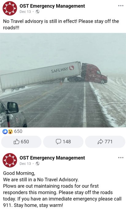
Did she really argue that a truck apparently ignoring "No Travel Advisory" and losing control on a non-federal highway in South Dakota somehow illustrates that we should not be preventing a critical global security issue with just a fraction of the US federal defence budget? 🤦🤦
2
5
111
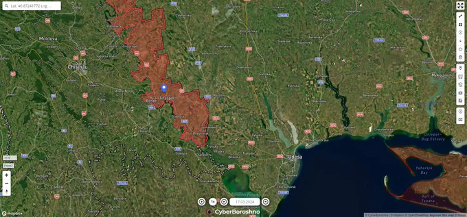
A Mi-8 variant helicopter, possibly a non-airworthy airframe stored at the location since perhaps at least 2003 (see 2003 Google Earth imagery below), was destroyed apparently by an attack UAV in Tiraspol, RU-occupied Transnistria part of Moldova.
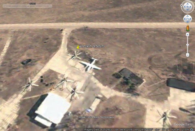
ФПВ дрон знищує російський Мі-8 в Тирасполі, Молдова
Tiraspol, Moldova
46.872417, 29.585273
@GeoConfirmed
@UAControlMap
Source:
7
17
86
5
26
115
@OAlexanderDK
One explanation it was simply stolen and "Z" was put on to minimize the chance of friendly fire.
1
2
110
A NATO instructor's assessment of UA military currently training abroad: sky high motivation, complete focus, no nonsense, extremely fast learners, know exactly what and why they need.
Support Ukraine politically, financially, and with materiel - UA Armed Forces will do the rest
1
25
112
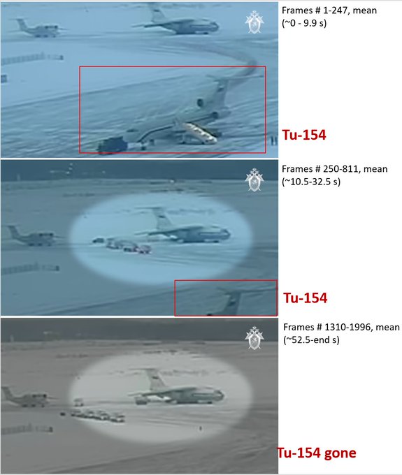
One additional observations about the video: the Tu-154 (bottom right, red rectangle) is gone in the latter part of the video after a cut => this could help date the video eventually.
Note: to reduce video image noise I took the mean of indicated frames.

4
19
113
@grntmedia
Ріст відбувається імовірно через те, що Старлінк завідомо збитковий проект, його керівництво нещодавно не отримало велику субсидію від уряду США (біля мільярда доларів), було змушене просити ще ~два мільярди у інвесторів і всеодно очевидно втрачає гроші зі страшною швидкістю..
3
0
106
@ChungTzuW
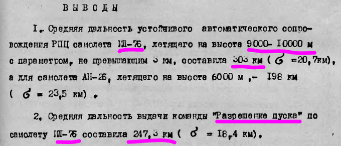
One thing for sure, S-200V can auto track IL-76 target at 300+-20 km range, and can launch a missile at 247+-18 km according to this test that was done back in the 80s:
7
15
114
This distance closely matches the distance from POV to Sergey Kotov based on known size of Sergey Kotov, TWIN STAR, and the approximate distance to TWIN STAR from the POV / IDEL 4 (from the AIS and relevant satellite imagery).
2
2
111
Please also see
@kromark
's great thread for very informative additional evidence (satellite imagery and social media photography).
Quick 🧵Geolocation of the Ukrainian naval drone attack on the Sergei Kotov patrol boat (together with
@Dmojavensis
,
@COUPSURE
, and
@LolManya
), based on HUR and (mostly, because it's of much better quality) TG video.
4
51
364
1
2
111
@no_itsmyturn
How come they are all cleanly shaven after 40 days of fighting under constant shelling?
1
3
103
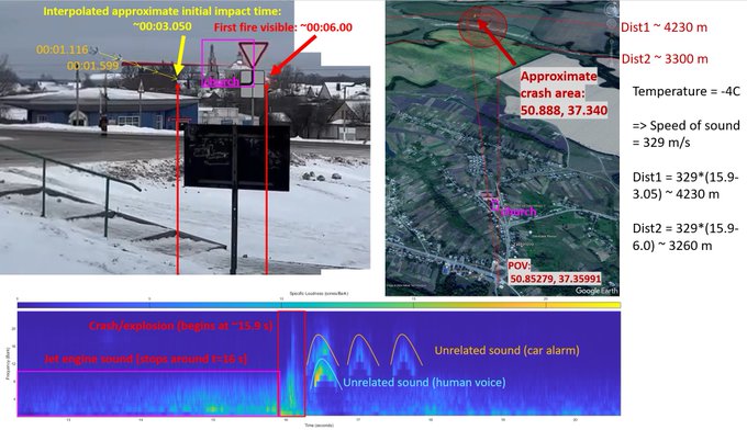
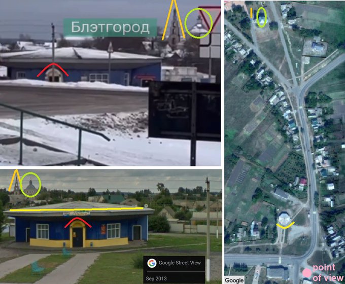
RU IL-76 crashed earlier today (24 JAN 2024) in Belgorod oblast.
Analysis of the sound from a video recording of the crash reveals crash location (based on sound/light delay): ~50.888, 37.340
There likely was an explosion within first ~0.3 seconds of the crash.
@GeoConfirmed

@bayraktar_1love
Location point of view: Yablonovo (Яблоново), Belgorod Oblast, Russia at 50.85293, 37.36006
@UAControlMap
#geoconfirmed
@GeoConfirmed
A Russian IL-76 plane, said to be a military one, hits the ground and explodes.
1
12
75
7
19
109
According to AIS IDEL 4 did not move much since 22:05 UTC, 04 MAR 2024 (nearly the time of the attack, which per HUR's interception of RU communications was near 21:50 UTC (00:50 local time) )
1
2
108
Explosion seen in Sebastobol today, Strilets'ka Bay.
Based on the geolocation the explosion happened over water (see below).
POV: 44.599121, 33.460504
Apparent explosion: 44.602521, 33.468162 (based on azimuth & sound delay analysis)
#Dmojavensis_location
@GeoConfirmed
Bavovna/explosions/shooting is being reported in RU-occupied Sebastopol. RU sources report a USV (marine drones) attack.
(verification and geolocation a little later)
1
3
1
5
20
105
@JayinKyiv
Ha, he said he's ready to talk after certain conditions. Sure, like stop fire and get your troops out of Ukraine's 1991 borders (including RU Black Sea fleet out of Crimea) -- that's the only minimum condition that makes any sense at this point.
1
10
97
@KeepItMeIIo
@nexta_tv
- An-225 is basically a stretched An-124, therefore Antonov DB might already have most parts in place
- The second fuselage has been sitting around for years waiting to be rebuilt
- Strategic airlifter won't hurt to have (to transport generators, locomotives, mil cargo to UA)
2
19
97
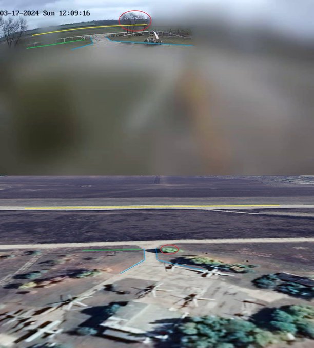
Tiraspol UAV attack (17MAR2024): here we demonstrate that the video of the attack appears genuine, video artifacts are likely due to frame rate conversion, not editing.
Camera/explosion distance estimated from the video is consistent w/ POV geolocation
🧵
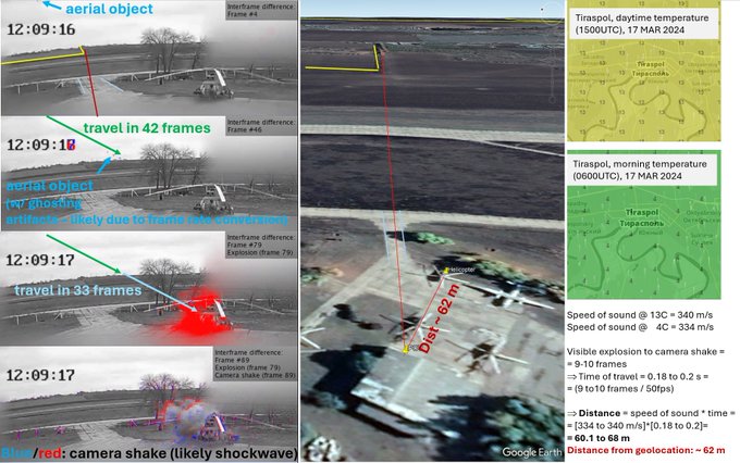
To better analyze the video of an apparent UAV attack of a Mi-8 helicopter in Tiraspol (RU-occupied Transnistria part of Moldova, 17MAR2024) we generated a video that highlights differences between video frames: red = pixels got brighter, blue = darker.
See analysis below👇🧵:
2
1
2
6
21
104
Or this one from late 2014 (I believe):

6
6
101
New road and possibly bridge construction can be seen in Sentinel-2 imagery near RU-occupied Staromar'ivka, Donetsk Oblast. May be related to reported RU railroad branch construction (below).
Possible bridge construction: ~47.4236, 37.8615
#Dmojavensis_location
@GeoConfirmed
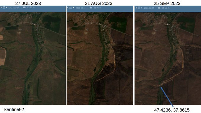

Окупанти будують залізничне спол��чення з Маріуполем, Волновахою і Донецьком – Андрющенко
15
18
22
8
27
100
"Ukraine has tweaked the Patriot’s software to enable it to track and destroy hypersonic missiles flying twice as fast as it was designed for"
"Raytheon [..] plans to deliver five more [Patriot systems] to Ukraine by the end of next year"
-CEO, Raytheon

4
25
99
@OAlexanderDK
Which makes it clear that NATO has never been current RU government's worry - it's been simply a cover and a domestic scarecrow justifying those atrocities which RU government (thought that they) could get away with.
4
9
94
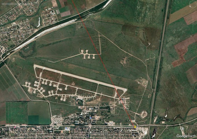
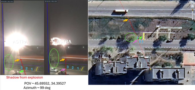
Explosions in the direction of Dzhankoi airfield (RU-occupied Crimea) reported morning 17 APR 2024.
POV ~ 45.69552, 34.39527
Azimuth ~ 99 deg (based on the shadows from the light of the explosion)
@GeoConfirmed
video src: (see next msg)
4
21
99
As early as 2007 Wojskowe Zaklady Usbrojenia Nr 2 (WZU-2, Grudziadz, Poland) announced working on adapting Sea Sparrow RIM-7 missile to 2K12 Kub (SA-6) SAM system -- Buk predecessor. In 2012 a prototype was shown using RIM-162 ESSM missile on 2P25 Kub launcher.
->
2
14
96
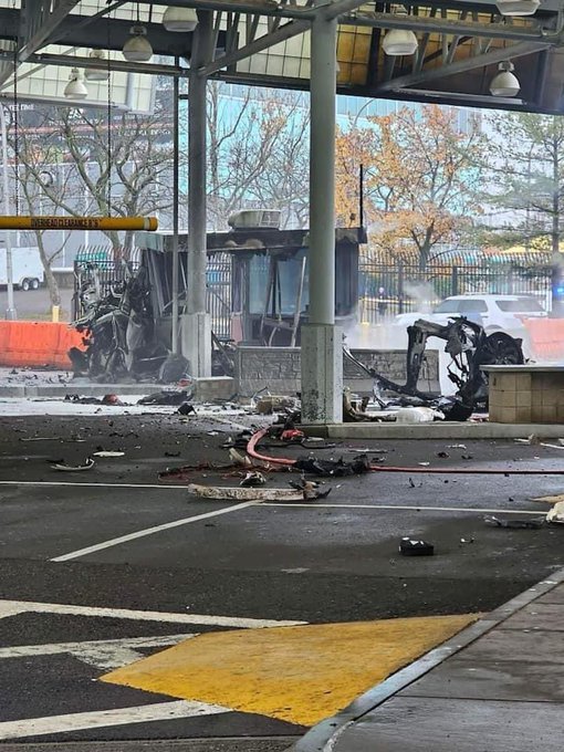
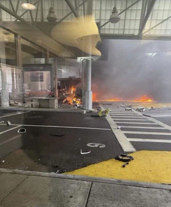
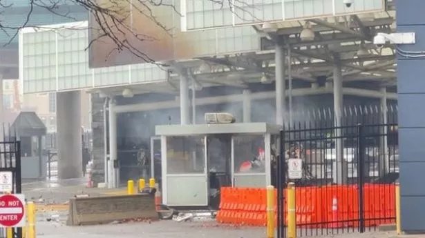
There was an incident about an hour ago at Niagara Falls US/Canada border crossing , where a car crashed into the crossing and "exploded".
I've seen some media already misinforming what is known about it.
So, to be clear, based on geolocations the car came from the US side:
🧵
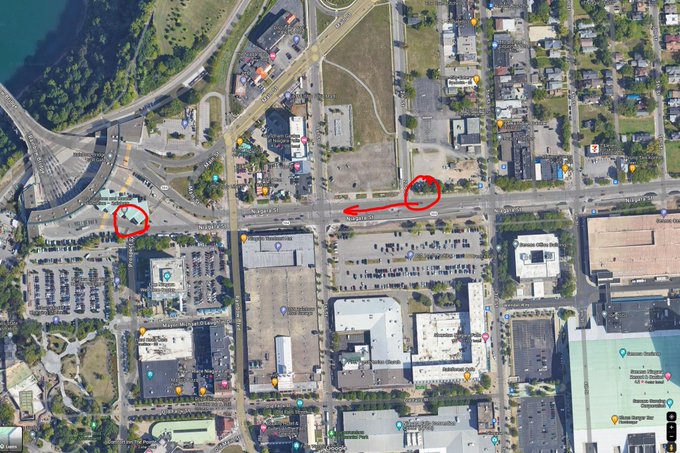

The explosion at the Rainbow Bridge at Niagara Falls appears to have occurred at the CBP checkpoint at the bridge.
The FBI has confirmed a vehicle exploded.
48
371
843
2
27
96
Conclusions:
- the drones (or whatever was in the air) have certainly reached the airbase.
- given that social media reported around "half-hundred explosions" we'll wait for satellite imagery for proper damage assessment (this video only shows 5 of them).
3
3
93
@StarshinaZapasa
И это сказал президент страны (Украины) на которую россия напала еще в 2014 и где даже до 24.02 уже погибли десятки тысяч граждан..
0
3
90