
Rob Perillo
@robperillo
Followers
12,896
Following
2,125
Media
15,898
Statuses
30,578
Chief Meteorologist KATC Lafayette, LA - Weather for Acadiana/S LA. Forecasting for Gulf Coast since 1985. 2020 Tropical Weather Conference Broadcaster of Year.
Lafayette, LA
Joined March 2009
Don't wanna be here?
Send us removal request.
Explore trending content on Musk Viewer
-360度カメラ
• 8354443 Tweets
Back to Back
• 824457 Tweets
Sant Rampal Ji Maharaj
• 224710 Tweets
#23point5EP9
• 95092 Tweets
WIN X VELENCE
• 89070 Tweets
#スポ男
• 84730 Tweets
ONGSASUN LOVEBIRDS
• 72881 Tweets
#दहेज_दानव_का_अंत_हो
• 41660 Tweets
ゴジラ-1.0
• 34461 Tweets
猫の恩返し
• 32715 Tweets
ガルアワ
• 29537 Tweets
Marco Reus
• 28312 Tweets
ランウェイ
• 25344 Tweets
雇用統計
• 21400 Tweets
長嶋茂雄
• 19060 Tweets
AGAINST ALL ODDS BINGLING
• 15610 Tweets
まことお兄さん
• 15445 Tweets
दहेज मुक्त
• 14592 Tweets
AMOREPACIFIC HQ WITH GULF
• 10782 Tweets
だいちゃん
• 10775 Tweets
#فيصل_ابو_رميه
• 10406 Tweets


WOW! Time-Lapse of
#HurricaneIda
courtesy of
@HurricaneTrack
at the Frenier Landing Restaurant in LaPlace...
#LAwx
40
993
3K
More spectacular waterspout video offshore SE Louisiana earlier today. Video courtesy of Raney Frederick.
#LAwx
80
816
2K
Incredible time lapse:
#HurricaneIda
's surge from Lake Pontchartrain at Frenier Landing in LaPlace as storm tide ultimately sweeps away camera, which never stopped working-wound up in a tree! About 40sec in notice black pick-up truck & white van that get swept by the surge.
#LAwx
12
273
684
1) Incredibly rare video of "Crown Flashing" from Pilot Donald Clay flying around a t-storm yesterday near Lake Pontchartrain. If you look over the top of the storm some pretty wild optical effects...This occurs when lightning in the storm below...
#LAwx
18
162
412
Meanwhile on the other side of the globe, Super Typhoon
#Hagibis
in tropical Western Pacific is sporting 160 mph Cat 5 winds & raked N'rn Mariana Islands today, but well north of Guam.
This storm is expected to impact Japan Friday into the weekend as a category 2 or 3 storm.
43
299
384
Thanks to Don Meaux for giving us our first look at Cypremort Point post
#HurricaneLaura
& his famous Surge-O-Meter! Fortunately high water marks were below that of hurricanes Ike & Rita! And the water has receded more rapidly than anticipated.
#LAwx
4
113
379
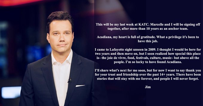
New contract signed, sealed, delivered and I’m yours! Thankful for another 5 years of getting to serve the Acadiana community with KATC!
And I'm excited to be part of the "news 3.0" transformation" in KATC’s neighborhood network initiative...you may have already noticed we…

30
7
268
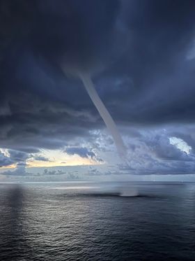
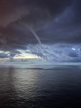
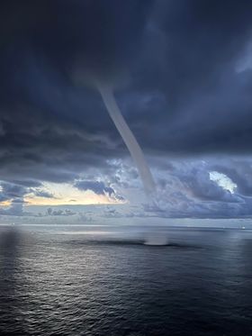
Now that's close! Awe-inspiring video of a
#waterspout
near Grand Isle Friday morning! Rainbow included! Courtesy: Debbie Leger
#lawx
4
122
241
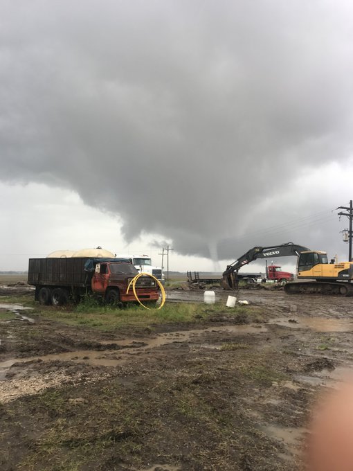
Huge tornado courtesy of Tommy & Heather Welch shot in Beauregard P. that was on ground for better part of 40m & went on into Rapides P. west of Alexandria. Doppler velocity maxed at 141mph (just west of AEX) which is well into EF2 range & could have been stronger at times!
#LAwx
13
120
234

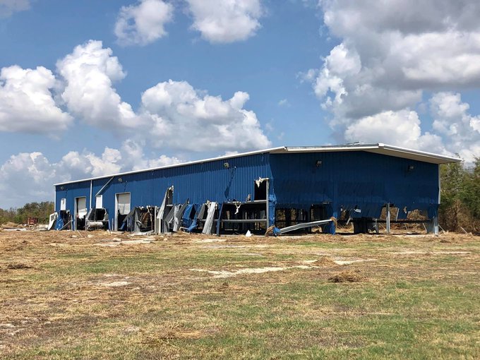
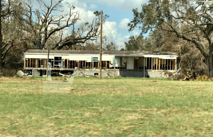
Day 2
#HurricaneLaura
survey...down Highway 82 to Grand Chenier where Twin Oaks Subdivision was just swept away by a solid 12-15ft of water equating to a 16-18ft surge. No personal belongings left here just building/trailer skeletal remains. Not even a bird can be heard.
#LAwx
17
141
230
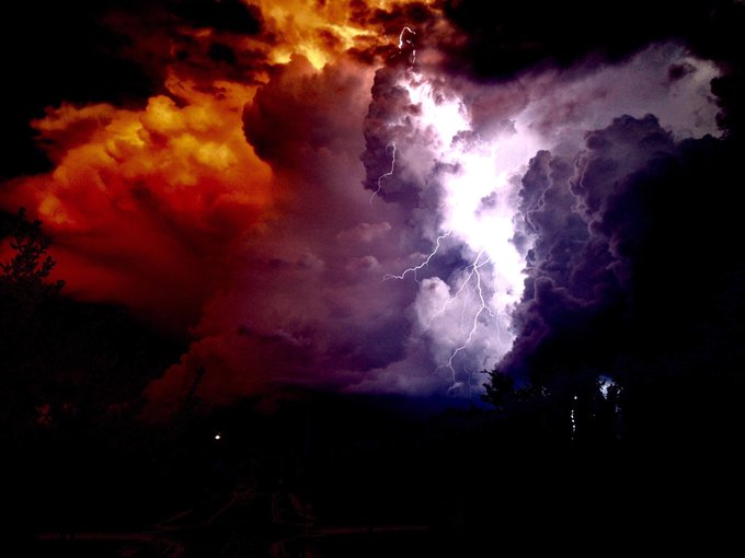
Incredible shot of lightning taken last evening in Houston by former Acadiana native Coy Gisclair!
#TXwx
9
67
205
Multiple vortices up with the tornado in New Iberia earlier. Significant damage to homes, businesses & at the Medical Center. Video courtesy of Lizzie Taylor.
#LAwx
3
78
205
Today is my 35th broadcast anniversary serving Acadiana!
This year I'm marking several personal career anniversaries! In addition to being in my 20th year at KATC, I’ll be celebrating 35 years as a Broadcast Meteorologist in Acadiana this coming July, and my 40th year as a professional meteorologist!
14
7
150
24
9
204
6 years ago today Cat 4 Hurricane Harvey makes landfall. It went from a tropical disturbance to 130 mph winds in a just over two days.
The storm slowed and stalled, and went on to be one of the most prodigious flood-makers in U.S. history. Harvey produced a multiday total of…
14
56
188
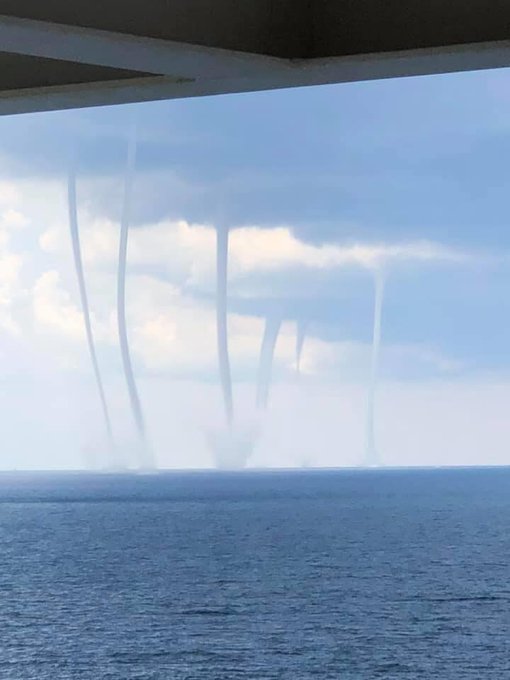
Incredible! Looks like the War or Worlds waterspout invasion! In the Green Canyon area today Courtesy if John Wirth!
#LAwx
3
59
184
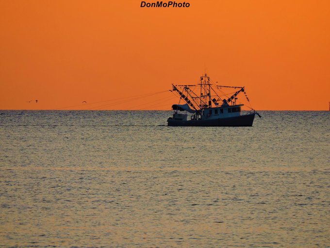
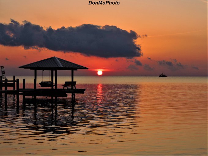
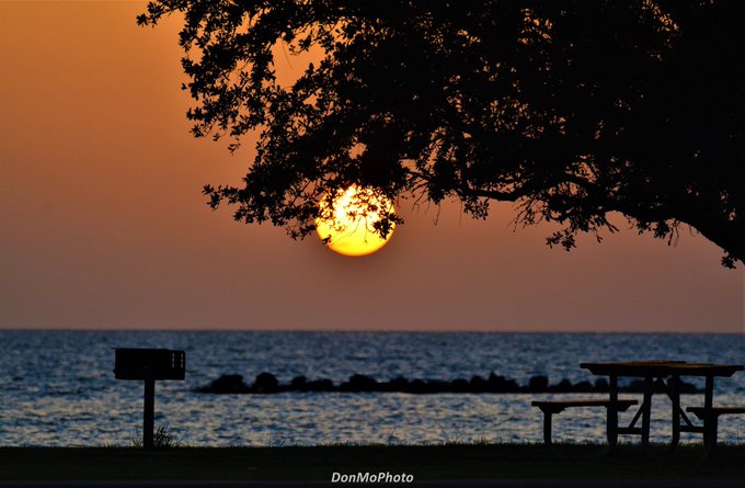
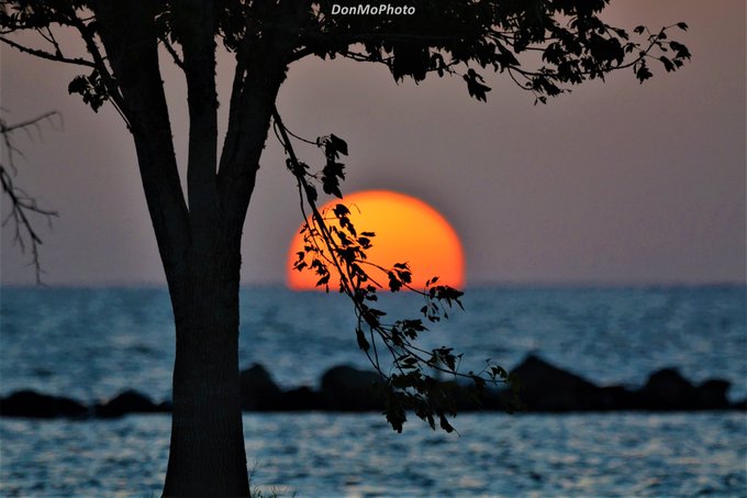
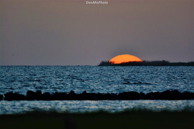
Stunning sunrise shot in the Atchafalaya Basin near Ramah, LA by Craig Philip LaBorde!
#LAwx

5
21
187
How hot & dry has it been in Acadiana? This picture is NOT from the desert, but the marsh in Cameron Parish! Pic courtesy of Rafe Courville!
#lawx

6
50
165
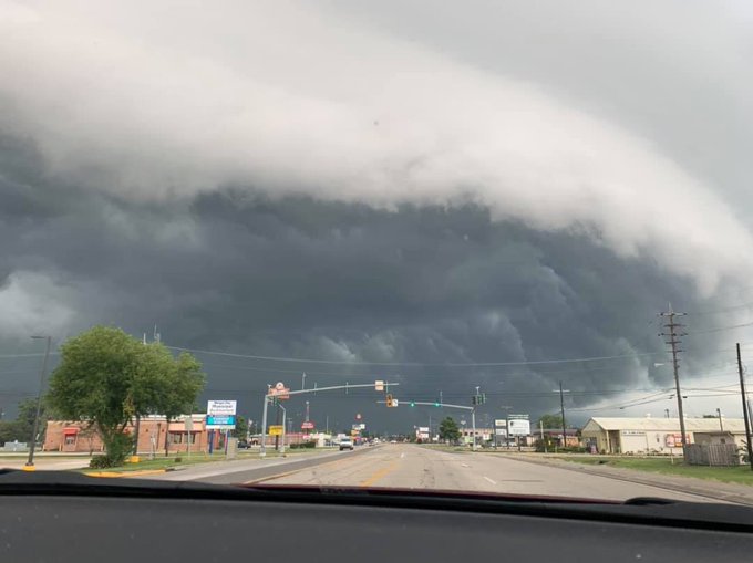
Looking like it’s a scrub today…

27
44
159
Rest in peace Ben Terry. Grateful for your friendship, unwavering commitment & contributions to the community, and the genuineness you brought to our local conferences and weather outings. You fought bravely and with courage through storms, personal disasters and life. You’ll be…

6
9
161
Guess who’s back in the Weather Lab? Whether you like it or not I’m glad to be back in the saddle!

9
9
156
This year I'm marking several personal career anniversaries! In addition to being in my 20th year at KATC, I’ll be celebrating 35 years as a Broadcast Meteorologist in Acadiana this coming July, and my 40th year as a professional meteorologist!
14
7
150
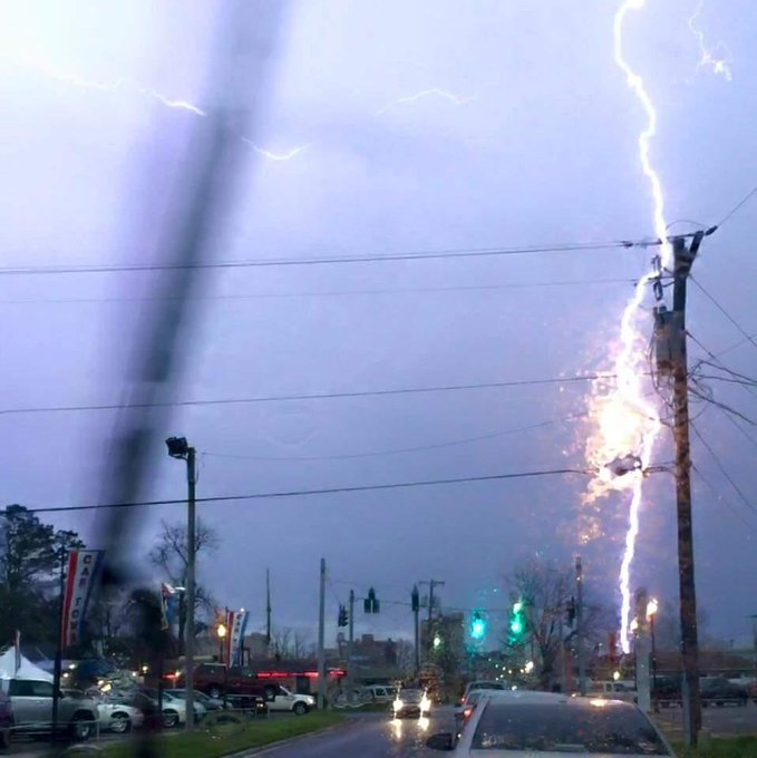
When lightning strikes less than 100 feet away...scary! Photo taken by John Moore in West Monroe.
#lawx
13
130
140
Thanks to all for trusting us with your news and weather! The Official Community’s Choice Awards for
#BestofAcadiana
!
#KATC

16
5
137
UNBELIEVABLE! Otis went from a tropical storm to a Category 5 with 160 mph winds in just 12 hours! Catastrophic damage where this system moves onshore near Acapulco overnight. Hurricane Warnings from Punta Maldonado westward to Zihuatanejo.
#MXWX
3
48
133
66 years ago today the strongest hurricane on record to strike the U.S. in the month of June made landfall in SW LA. In 1957, Hurricane Audrey was responsible for at least 500 deaths. The exact number will never be known, as many perished in the storm surge in Cameron and…
2
37
127
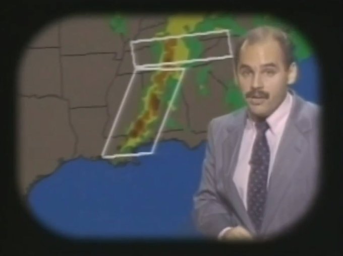
Today marks 34 years on the air In Acadiana and counting! Here's a snippet of my first weekend weathercast with some old friends! Learned the 1st rule of broadcasting on that very day: don't try cracklin for the first time before a weathercast!
16
12
129
And so it has been done...110° in Lafayette today tops the all time record of 107° set on July 13, 1901! There are no other heat records to break. We've done them all, and can proceed to fall asap!
#LAwx
#climate
#climateamplification
=
#hottestsummer
6
37
122
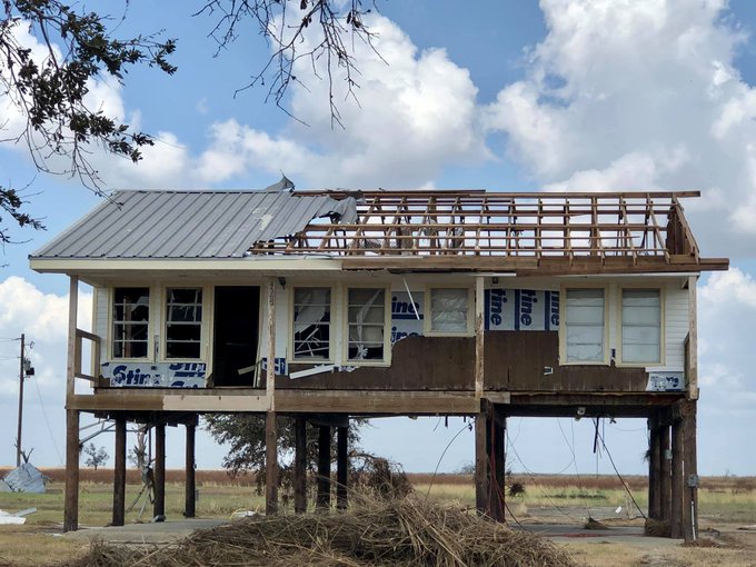
The Cameron Parish slogan is “Gateway to the Gulf” and Hurricane Laura throttled that gateway with what appears to be a 15-18ft surge/storm tide and waves into the Parish East of Cameron. Grand Chenier is all but destroyed. See my previous post for video.
#LAwx
#HurricaneLaura

6
80
117
#HurricaneIrma
's eyewall structure(s) edging, more like buzz sawing (using
@mattlanza
's term), into Barbuda now. Best of luck.
#tropics
8
105
111
Wow! Incredible video! Sunshine in the eye of the
#Michael
and beautiful perspectives of the stadium effect from the ground as shot by Stefan Melendez. Source with audio:
2
45
108
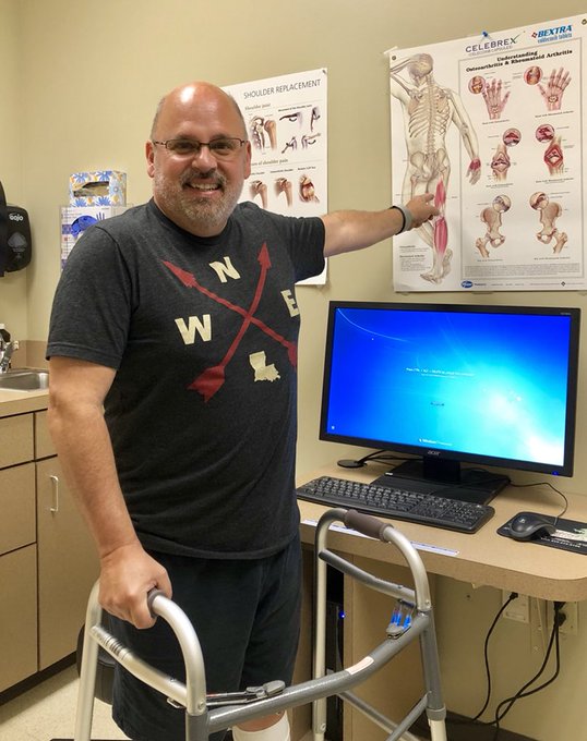
For those who have asked to my whereabouts, I had hip surgery last Monday & have been working on rehab & physical therapy. I’ll be out of the Weather Lab for a few more weeks as I get my feet back on the ground, literally and physically! Thanks for all the well wishes!
28
8
109
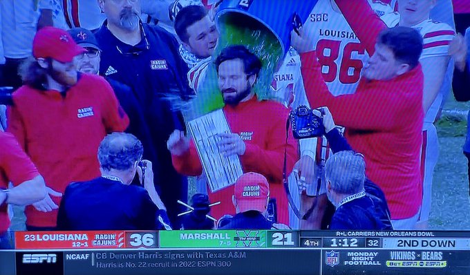
Wow! What a finish! Ragin Cajuns win 20-18 with a 53yd field goal with 2 seconds on the clock! Cajuns win & go 3-0 1st time since 1988!
#GeauxCajuns

1
15
105
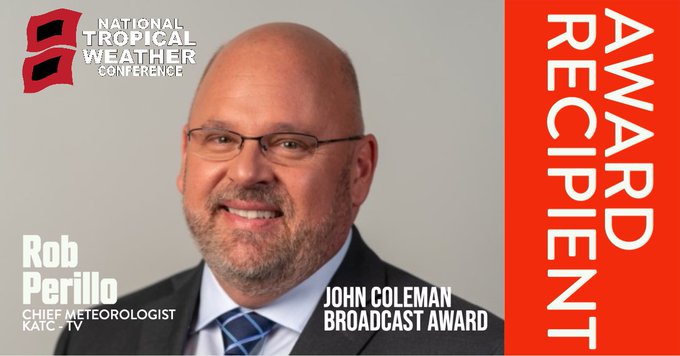
Shocked, stunned, humbled and grateful! Thank you
@HurricaneCon
for such an honor!!! Will have a statement forthcoming later today!

Congratulations
@robperillo
! 2020 John Coleman Broadcast Award winner.
@USAA
@PLYLOX
@SouthPadreTexas
1
3
34
27
3
104
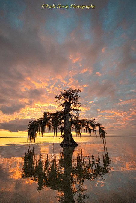
Beautiful cypress shot in the Atchafalaya Basin courtesy of Wade Hardy!
0
14
102
Now that Facebook is back...I can get back to curating and learning from the comments on my climate-related posts! Oh joy, said no one.
7
10
100
Today marks the 4yr anniversary of the infamous Historical Flood of 2016 where in less than 48hrs 20-30" of rain fell from BTR to Acadiana all associated a slow moving disturbance. A 15 billion dollar disaster responsible for flooding more than 155,000 homes & businesses.
#LAwx
3
44
96
Hurricane Idalia continues to go through a rapid intensification (RI) cycle and is on the verge of a Cat 3 with 110 mph winds. Expected to make landfall within hours of daybreak in Cat 4 territory....130mph or a little more.
#HurricaneIdalia
#flwx
5
38
95
I posted a pic of this downburst last week from a storm near El Paso. Here’s the perspective from the sky!
#txwx

5
29
94
Geez...hard to believe this happened in Lake Charles again...😢
1
19
96
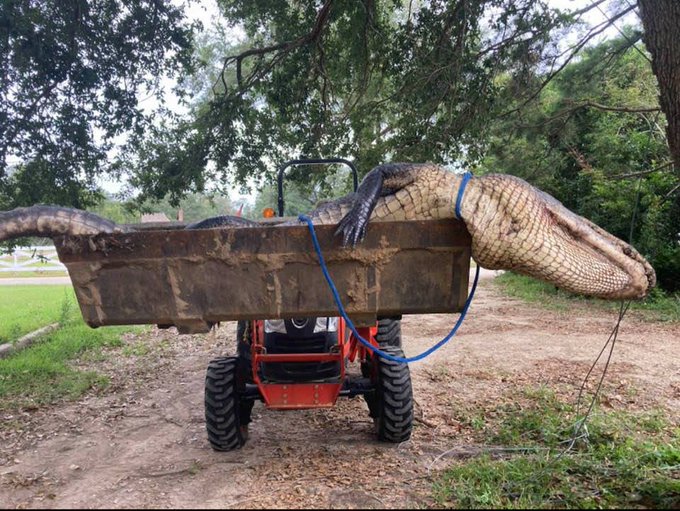
Super predator man-eating alligator. A Slidell man's remains were found in its stomach. Photo courtesy of Mario Sperandeo.
18
32
93
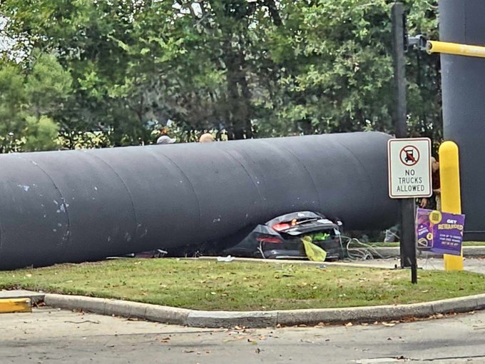
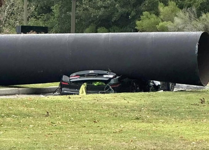
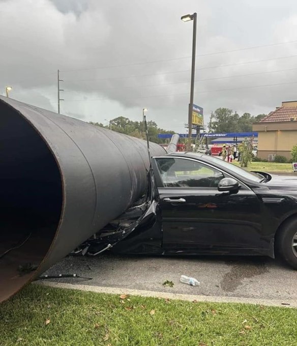
An unlucky day, but a lucky day too! Follow-up on fallen Taco Bell sign...woman (sole occupant) in the drive-thru is being treated for a head injury, but is expected to be okay. Last two images courtesy of EVEN News: Acadiana’s News Outlet
#LAwx
7
27
91
Ragin Cajuns beat Georgia St, are 8-1 and 6-0 in Sunbelt! On the road to the Sunbelt Championship for the 4th straight year next!
#GeauxCajuns
3
12
87
First Gatorade bath is the best! Congrats to the
@RaginCajunsFB
on their greatest season on record! 13 is a lucky number!
0
9
86
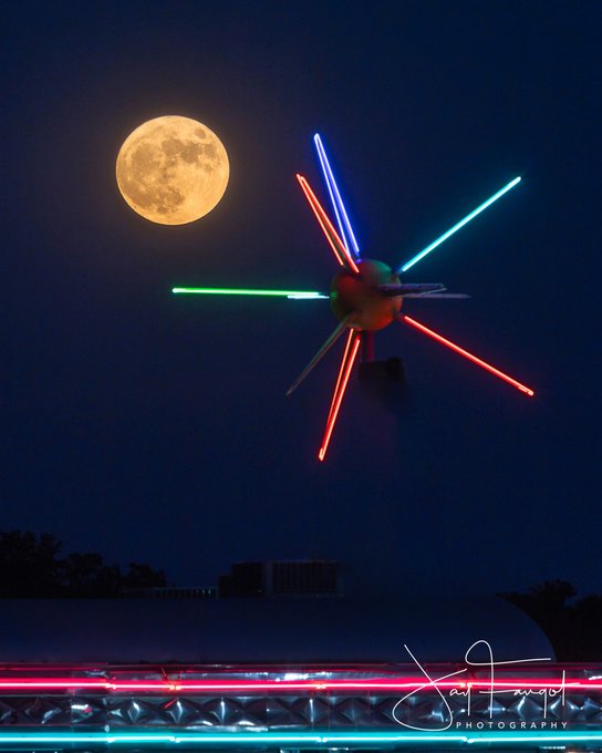
Love this super moon pic taken at Mel's Diner in Broussard, LA! Photo by Jay Faugot!
#SuperBlueMoon
3
22
86
Impressive video of the tornado in Pecaniere, south of Port Barre in St Landry Parish sent in by Cameron Norris. No damage from this one (in open fields) that occurred around 1pm...
#LAwx
1
38
82
This is how I’d throw my first pitch out too!

8
7
80
Now we’re really in trouble!

With Drew Brees out we can only count on one man to save us

0
146
460
4
12
80
5 day evolution of
#Michael
. A 40mph tropical storm to high end Cat 4 storm with 155mph winds in 72 hrs. Another tropical system that reminds us how quickly storms can intensify w/devastating results. Incredible how the storm strengthened & eye became most perfect at landfall.
2
39
77
Impressive dust devil shot from the bridge in Baton Rouge! Video credit Brian Gaspard's passenger!
#LAwx
0
12
78
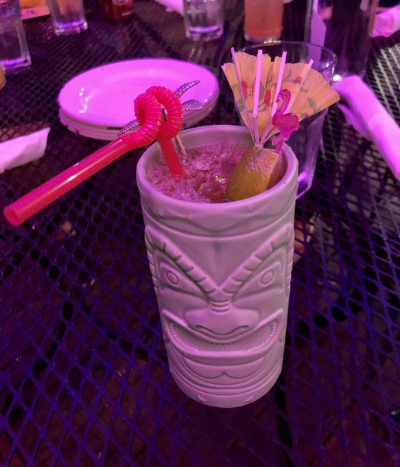
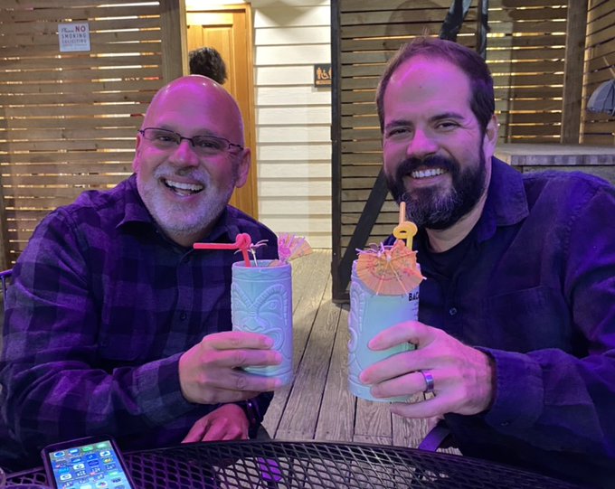
Just discovered the “Perillo Punch” served at Spoonbill! It’s their take on a hurricane! Notice the blown umbrella! And no I’m not working the 10pm show tonight!
#LivingInTheCone
0
2
77
Already in the display rack at
@KATCTV3
! Although I have more than a couple of dozen of these, this one is more special, as we now compete with Mississippi in addition to Louisiana & this particular award is a judgement of your body of work throughout the year....
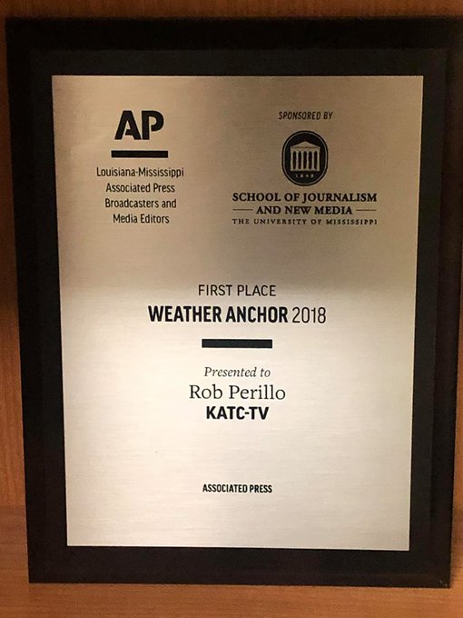
8
3
77
If you missed it earlier, Lafayette native Boo Freeman shot this beast of a waterspout near Destin earlier today. Fortunately the storm was heading offshore, not inland...
4
23
76
The invasion is almost complete! Awesome lenticular clouds!


4
12
69
Hopefully I may some day become synonymous with sunny days soon!

2
24
73
Dramatic home security video and audio of the St Martin Parish EF1/EF2 tornado last night courtesy of Lindsey Meche in the Breaux Bridge area. Luckily there as no major damage...and Lindsey slept through it!
#LAwx
4
18
71
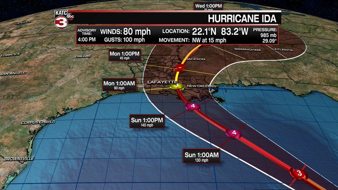
#HurricaneDelta
near a Cat 5 when grazing Yucatan tonight-Wed morning...expected to remain near major hurricane status for a LA landfall late Friday. Forecast track nudged westward with landfall in Vermilion Parish and then right through Lafayette...
#LAwx
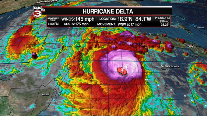
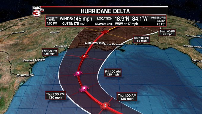
5
58
60
How far off the charts this summer? Prior to this year, in the last 40 years Lafayette recorded a total of 32-100° days! This year alone we already have 20-100° days and will be looking to add 8-10 more in just the next 10 days!
And 28 out of the last 40 years we had zero 100°…
7
19
71
Looks like the Arctic Ocean in the Gulf of Mexico this afternoon! Strong winds and steam fog (as the cold air meets the warmer water it produces condensation in the form of a fog). Video courtesy of Philip Primeaux!
#LAwx
1
26
69
Take that Dimorphos!

NASA's DART impact changed asteroid's orbit forever in planetary defense test

9
41
192
3
11
68
1
7
68
Now that's cold!

0
17
67
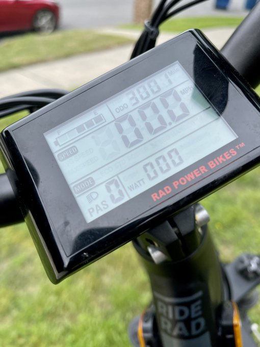
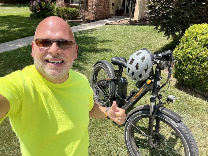
3001 miles in 364 days! Early last year I made the commitment to lose weight (35lbs) & get in shape & I’m happy to say I’ve stuck with the program of fewer carbs & peddling 6 days a week! Thanks
@radpowerbikes
!

8
3
69
3 years, 7,500 miles & 35lbs later still peddling away…and it’s a better workout in the heat! I’ve made a theoretical trip to Juneau, Alaska and back…with no hills! 🤣🚴♂️

7
1
68
Beautiful waterspout shots (and lighting) Saturday morning shot out in the Gulf of Mexico courtesy of Mario Pecoraro!
#LAwx
2
11
66
Back on shift today and doing some
#HurricaneDelta
archiving...here's a 5 day enhanced satellite movie of the storm...was ugly at landfall but even uglier to Louisiana...
#LAwx
3
12
65
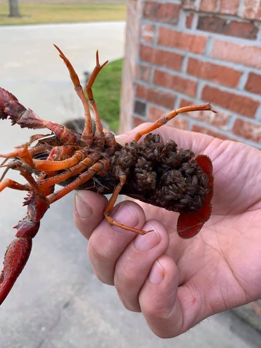
Ever wonder where baby crawfish come from? Shots of mama and her craw-babies courtesy of Shawn Murphy in Rayne!
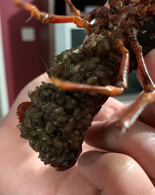
16
16
63
Needless to say...an emotional week. Best co-anchors I've EVER worked with, and dear friends/bonds for life...
4
1
67
Just a couple of weather nerds…I mean paisans! Great getting to hang with
@JimCantore
last couple of days!

0
5
66
Tornado spotted near Port Barre in St Landry Parish around 1pm this afternoon...storm has moved out of the parish and has weakened. Photo courtesy of Chris Hawkins.
#LAwx
0
21
61
#Michael
has become an extremely dangerous Cat 4 hurricane with 130mph winds...sat imagery shows the storm has become quite symmetric in the last few hours all but insuring a life threatening storm surge and extremely damaging hurricane winds are imminent for Florida Panhandle.
8
45
57
105° today in Lafayette shattering the all-time high temp for any August of 104° set on August 30, 2000! Previous record for the date was 100° set in 1896 & 1999. Records date back to 1893.
The hottest temperature for any month was 107° on July 13, 1901..and that record is in…
4
14
64
Humbled & grateful to be nominated! Congrats to my fellow nominees!
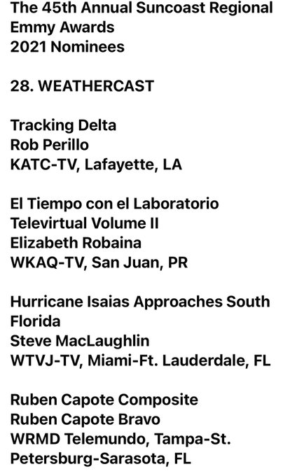
4
2
64
Meteor! Spotted from Georgia to Texas! Video taken near Carencro, LA at 4:32 am this morning! Doorbell camera video courtesy of Travis Standalone Daigle!
Per the American Meteor Society there were more than a dozen reports of this fireball! Pending reports:…
6
18
61
On site storm surveyor Roger Erickson with the NWS is going to classify the Palmetto tornado as an EF2-EF3 on a scale of 0-5 with 130-140mph winds...sadly 15 homes damaged or destroyed, 7 injuries and one fatality reported.
#LAwx
1
30
61


1
13
62
Following some folks criticizing the National Hurricane Center's
#Dorian
forecasts...other than not know when the turn to the north would occur due to very delicate steering influences, the storm has stayed well within the cone of uncertainty through its entire life-cycle...
3
20
59
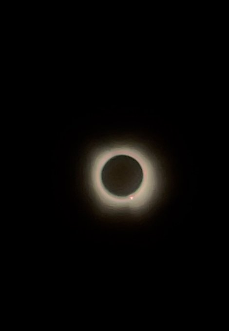
GOT IT! In Gatesville, Texas! Some clouds but still AWESOME experience! (Screen shot off of video)
#eclipse
5
3
62
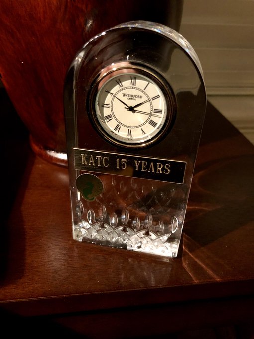
Didn’t get a chance to post Saturday night but I received my 15 years of service award from KATC! Time has flown! Looking forward to many more! Blessed to work for the our company and to be of service to our community for the last 30+ years !
4
4
58

The Gumbo WATCH for Acadiana this weekend officially has been upgraded to a Gumbo WARNING! Lows heading for the lower 50s! Remember a burn ban is in place...so no burning the roux!
#LAwx
1
9
60
Pausing tropical coverage for this simply awesome pic and auroral phenomenon on Saturn!
'Aurora around Saturn's North Pole' image from the
#NASA_App

1
14
60
If you showed me this graphic at the beginning of the season, I might have taken a sabbatical...3 hurricanes, 3 tropical storms (
#Marco
was more like a depression when it ran through Acadiana) &
#Beta
as a depression.
#LifeInTheCone
#LAwx
#Cristobal
#Laura
#Delta
#Zeta
#2020
2
16
59
Beautiful, yet so dangerous. 1 Min
#GOES16
visible satellite imagery showing Major
#HurricaneHarvey
about to make landfall.
#txwx
#lawx
2
51
57