
Santa Barbara County
@countyofsb
Followers
24,279
Following
456
Media
1,908
Statuses
8,475
Official Santa Barbara County government Twitter site. En español: @csbenespanol
Santa Barbara, CA
Joined August 2013
Don't wanna be here?
Send us removal request.
Explore trending content on Musk Viewer
オーロラ
• 512991 Tweets
#Eurovision2024
• 378867 Tweets
Joost
• 346630 Tweets
#الهلال_الحزم
• 128912 Tweets
Forest
• 124323 Tweets
الدوري الاقوي
• 83360 Tweets
Reece James
• 59804 Tweets
الدوري السعودي
• 55519 Tweets
Ali Koç
• 51286 Tweets
Brahim
• 43372 Tweets
الدوري التاريخي
• 42659 Tweets
Granada
• 41228 Tweets
Arda Güler
• 39335 Tweets
Burnley
• 37697 Tweets
Rohit Sharma
• 34291 Tweets
#الدوري_الاقوي_في_التاريخ
• 26724 Tweets
DiniKonferansa TehditVeEngel
• 26400 Tweets
Luton
• 25874 Tweets
Sterling
• 20661 Tweets
Mudryk
• 18653 Tweets
#KKRvsMI
• 16917 Tweets
Poch
• 14094 Tweets
Caicedo
• 14064 Tweets
نيمار
• 14025 Tweets
Odoi
• 11255 Tweets
كوليبالي
• 10409 Tweets


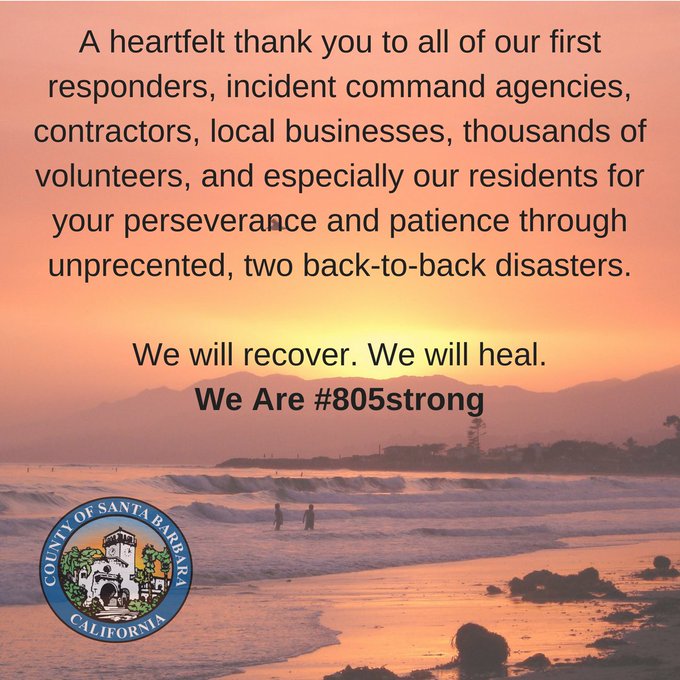
IMMEDIATE EVACUATION ORDER issued to the ENTIRE MONTECITO COMMUNITY. Includes all 15 zones of the Montecito Community, all Toro Canyon & Padaro Lane residents in the Carpinteria-Summerland Fire Protection District & all residents of Sycamore Canyon in the City of SB and Montecito
43
579
1K
HIGHWAY CLOSURES:
-NORTHBOUND 101 CLOSED AT THE 33, THROUGH SANTA CLAUS LANE
-EXPECT FLOODING ALONG SECTIONS OF NORTHBOUND 101 THROUGHOUT SUMMERLAND & MONTECITO, WITH INTERMITTENT CLOSURES & ON/OFFRAMP CLOSURES
-NORTHBOUND 101 CLOSED AT GAVIOTA
-HWY 154 CLOSED IN BOTH DIRECTIONS
7
124
250
Highway 101 will reopen to commuter traffic on Monday morning.
8
87
215
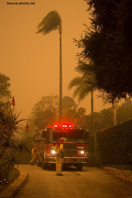
The
#ThomasFire
has burned over 269,000 acres...it is currently at 40% containment. Thank you to all of our brave
#firefighters
for their brave work.
4
58
177
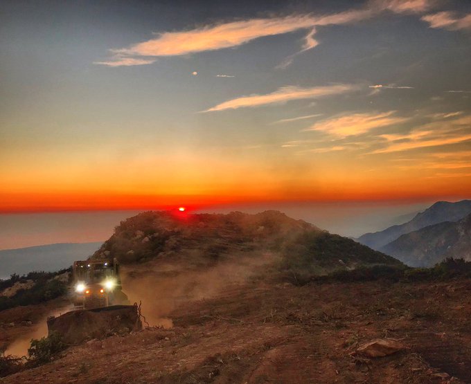
Resources involved in responding to the
#cavefire
include:
600 firefighters
5 bulldozers
9 helicopters
10 fixed wing aircraft, and more
Thank you to all first responders and to all the crews in the region who responded to assist
#SantaBarbaraCounty
2
39
165
#Repost
@eliasonphotos
,
County Fire PIO・・・
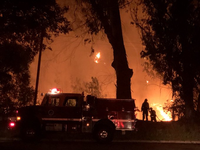
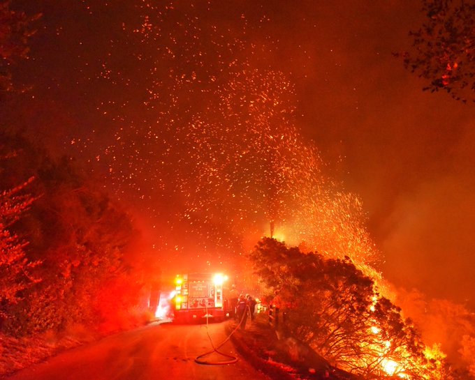
They’re called widow makers, trees that burn from the inside out, weaken the tree, and it falls. These two were on Refugio Road.
#alisalfire
#santabarbaracounty
#santabarbaracountyfirefighters
12
65
169
8 fatalities and 25 injuries have been confirmed within SBCounty due to the storm. 50 rescues have occurred thanks to our heroic first responders. For storm info, transport assist or to speak with a counselor, call the info line-(805) 681-5542 or text (805) 699-0165 or call 211.
5
151
151
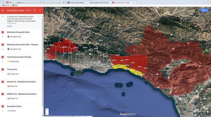
Serious storm approaching: Mandatory Evacuation Order effective at noon Tuesday for areas of extreme and high risk for debris flows. See full release at .
#SantaBarbaraCounty
#Carpinteria
#Montecito
#SantaBarbara
#Goleta
#SantaMaria
#ReadySBC
6
199
146

#CaveFire
Update- All Evacuation Orders & Warnings have been lifted in Santa Barbara County. Evacuated residents may now return home. Use caution and stay alert to surroundings & changing conditions in impacted areas. For related road closures info visit .
3
72
147
North to northeast winds are expected tonight, with low humidity. Thanks goes to our firefighters. As the sun set for the day, their battle with the Thomas fire will remain strong throughout the night, protecting our community.
#ThomasFire
2
42
143
Thank you to all of our Santa Barbara County Firefighters who continue to tirelessly protect our safety.
#Thomasfire
4
62
148
911 lines are jammed up; please only call if there is an emergency. Fire and public safety crews are active in the Goleta area with the
#holidayfire
. Thank you!
2
127
131
Door-to-door mandatory evacuation order notifications in the Extreme Risk areas began early this morning. Based on contacts made so far, the vast majority of residents are taking this evacuation order seriously and have left the area. We appreciate your continued cooperation.
5
64
136
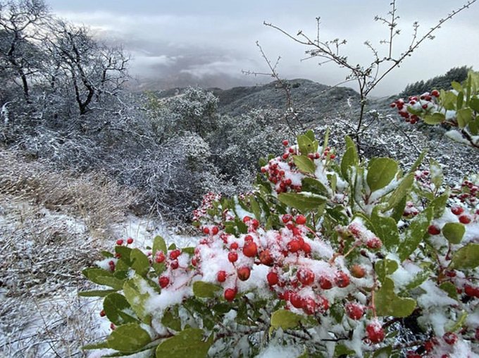
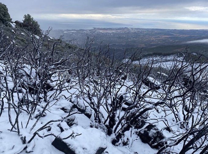
Favorite photo today from
#SantaBarbaraCounty
Fire PIO
@EliasonMike
- snow falling at 3500-ft level E Camino Cielo. Sure looks peaceful after all it endured from
#cavefire
. Happy Thanksgiving everyone!
2
33
136
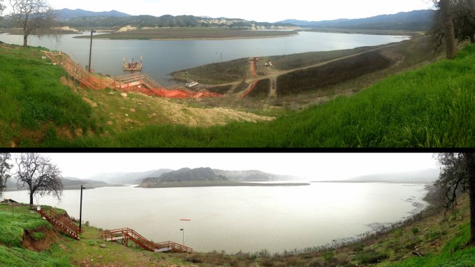
Cachuma Lake before and after the storms that have seen the lake rise more than 20 ft yesterday.
#Sbstorm
#Cachuma
#santabarbaracounty
2
92
132
Thank you
@TheEllenShow
and your partnership w/Cheerios to donate $25,000 to Santa Barbara Humane Society, which sheltered hundreds of pets thru the
#ThomasFire
& January Storm. We are
#805strong
and resilient and we will rebuild.
#castorm

0
37
133
#ThomasFire
Update- All Mandatory and Voluntary Evacuation Orders have been lifted in Santa Barbara County. All evacuated residents may now return to their homes.
2
55
118
Video recorded in the last 30 minutes from El Capitan by Santa Barbara County Battalion Chief Rob Hazard.
5
68
119
#HolidayFire
2,200-2,500 evacuated. More than 30 engines, 2 night flying helicopters, 71 law enforcement personnel on scene.
1
100
115
Today was officially proclaimed “Day of Remembrance of the Montecito Mudslides” in the State of California.
#805Strong
#SantaBarbaraCounty

.
@JerryBrownGov
Issues Proclamation Declaring Day of Remembrance of the Montecito Mudslides:
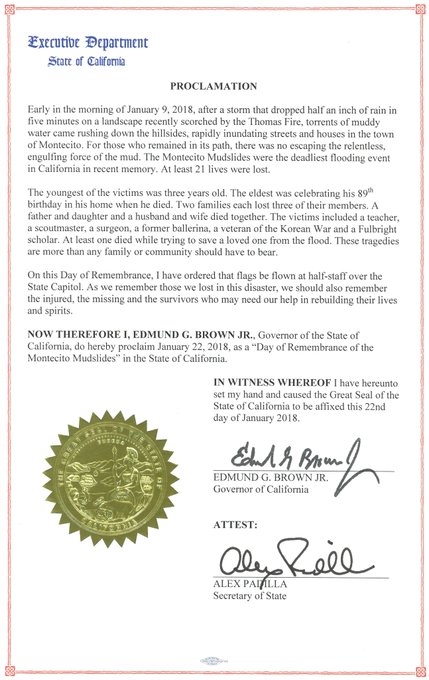
12
70
120
4
49
115
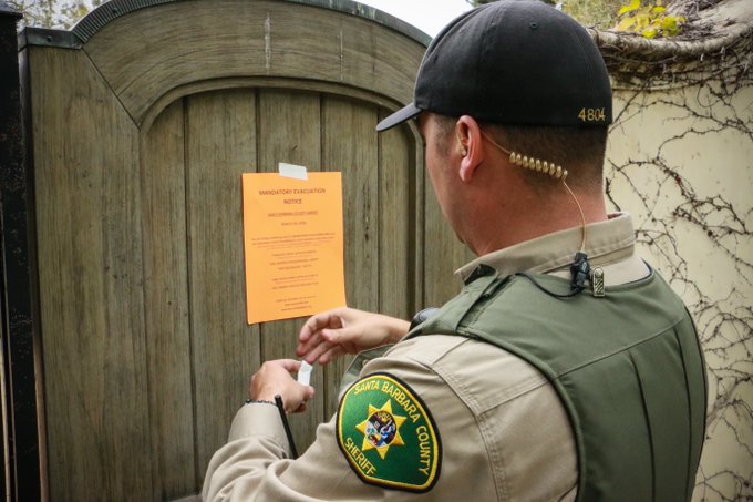
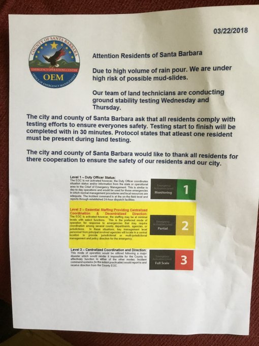
FRAUD ALERT: Postings like the one in this photo have been put up throughout
#Montecito
&
#SantaBarbara
. These are NOT OFFICIAL flyers & there is NO "ground stability testing" being conducted on personal property. If anyone attempts to enter your property call 9-1-1 immediately.
10
172
113
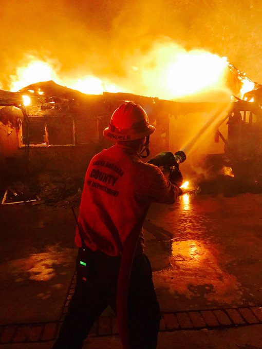
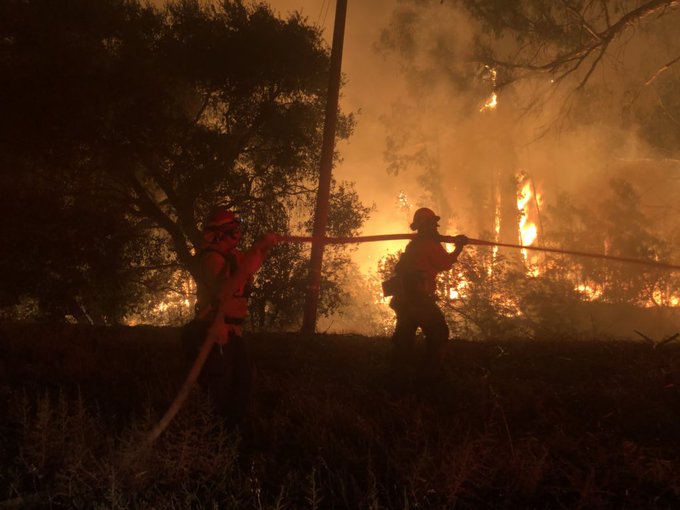
#Thomas
Fire. Firefighters NEED all our water resources. Restrict any outdoor water use and conserve indoors. Now is not the time to clear ash!

3
152
110
#thomasfire
update: The fire is actively burning in the Hot Springs drainage & along the N side of Santa Ynez range & running uphill. All current evacuation orders & warnings remain in place, but may change at moments notice. Please continue to remain vigilant & be prepared.
4
108
105
Please be advised: The Santa Barbara Airport is currently CLOSED due to flooding. All commercial flights are cancelled until further notice. For the latest local alerts, visit . For information about specific flights, please contact your airline directly.
0
56
109
All Santa Barbara County public schools will be closed Tuesday, Jan. 10, 2023. Outside of a mandatory evacuation order, decisions about school closures are made on a school-by-school basis. Families in private schools should look for updates from their individual schools.
0
57
109
Update: Immediate Evacuation Order also issued to all residents of Serena Park area in Carpinteria. Additionally, a SHELTER IN PLACE order is effective for Santa Barbara County impact areas associated with Cave & Alisal.
0
46
108
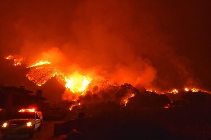
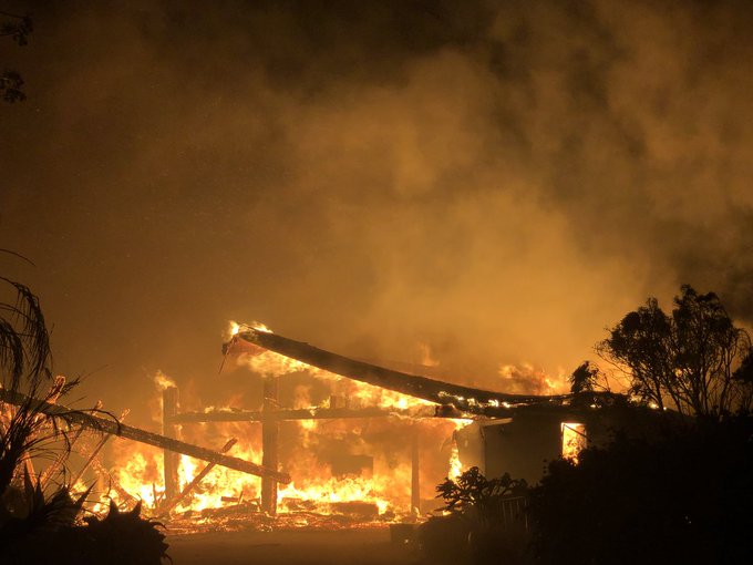
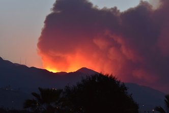
The
#thomasfire
acreage burned is now 236,000 acres with 25% containment. Best wishes to firefighters and all authorities tonight as they continue the battle. Mike Eliason of
@SBCfire
captured this image tonight above Bella Vista Drive, near Romero Canyon.
3
60
102
Evacuations have been issued for areas below the Thomas, Whittier, Sherpa and Rey Fire Burn Areas beginning at NOON TMRW Monday, January 8 due to an approaching winter storm. Full info & link to interactive map at: . You can also call 211.

2
150
94
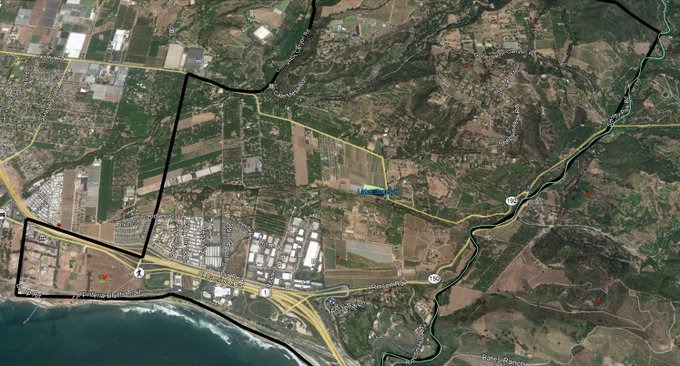
MANDATORY EVACUATION ORDER: Montecito and Summerland area - South of 192, North of 101, West of Toro Cyn, East of Summit Rd & Country Club.
3
151
95
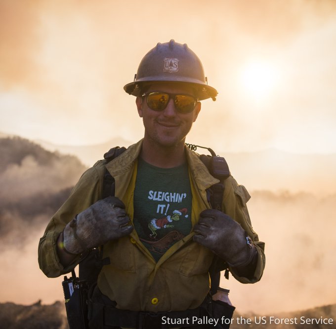
Many people will be home for the holidays thanks to the hard work of many. RT
@LosPadresNF
: It's beginning to look a lot like Christmas
#ThomasFire
Photo by Stuart Palley for U.S.F.S.
0
22
104
Even after the sun sets, crews are working hard to clean up and restore services in the debris flow areas.
#805Strong
@CaltransD5
6
37
99
#Cachuma
lake rose 20 ft with another 20' expected. Currently filling at .5-ft/hour.
#drought
#castorm
#sbstorm
#santabarbaracounty
3
47
100
The US-101 is back open in both directions throughout Santa Barbara County. Highway 154 is still closed in both directions at this time.
0
20
100
Evacuation tip: Keep your gas tank above half-full. This is especially important for residents in areas likely to be evacuated. Gas stations may be closed during emergencies and unable to pump gas during power outages.
2
76
89

Holiday Fire Update - July 7, 12:30 am:
50-80 acres and 10-20 structures burned; 2,200-2,500 people evacuated; 2,000 customers w/out power. Cathedral Oaks is closed between Carlo to Patterson.
4
106
96
Did you feel it? Waiting for USGS information on epicenter and size.
#earthquake
#santabarbaracounty
18
29
94
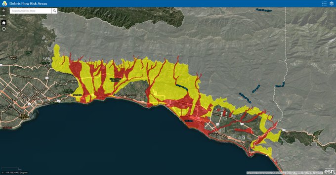
An interactive map of the debris flow risk areas and extreme/high risk areas is now available at .
#805strong
0
93
97
#cavefire
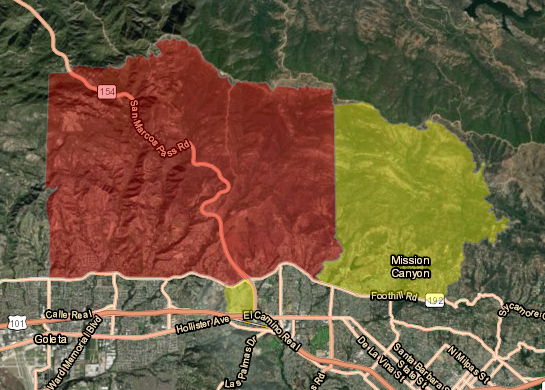
evacuation ORDER boundaries expanded to Fairview on the west, east to Ontare down to Cathedral Oaks. Maintain situational awareness. If you’re not in evac zone, self evacuate if you are concerned or need extra time.
3
64
91
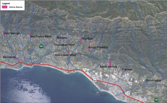
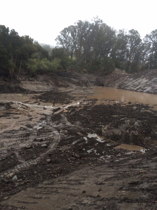
Debris basins above Montecito have been completely cleared of 1/9 Debris Flow material and stand ready for the storm. Santa Monica debris basin above Carpinteria is almost clear. More than 50,000 truckloads of mud, sediment, boulders, rocks, trees and trash have been removed.
2
52
96
A Pre-Evacuation Advisory has been issued for the Sherpa, Whittier, Thomas and Alamo Fire burn areas. NWS forecast indicates that a storm will be arriving Mon, Feb 26 in the afternoon and into Tues, Feb 27. For more info on the risk please go to .
3
105
89
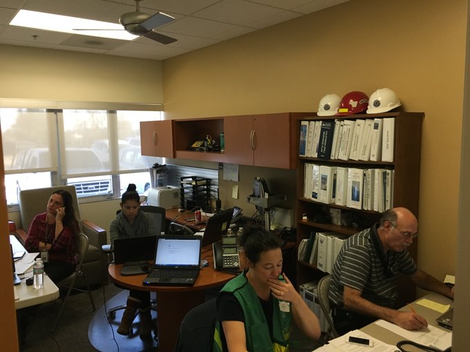
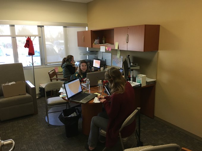
Thank you to all of our volunteers and county staff working in our
#ThomasFire
call center! The call center staff is working 24/7 and answering hundreds of calls to help residents get the valuable information they need.
2
22
94
#AlisalFire
- 7 a.m. UPDATE- 14,500 acres, 5% contained. 1,300 personnel assigned with more on the way. Hoping for favorable winds for fixed-wing aircraft to engage.
#SantaBarbaraCounty
1
41
89
TORNADO WARNING Issued by the NWS. TAKE COVER NOW! Move to a basement or interior room on the lowest floor of a sturdy building. Avoid windows. If you are outdoors, in a mobile home, or a vehicle, move to the closest substantial shelter and protect yourself from flying debris.
13
25
88
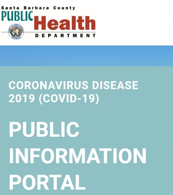
NO cases of
#COVID19
in
#SantaBarbaraCounty
. To address local measures to protect public health & slow transmission rate of COVID-19 County declares local Public Health Emergency, Health Officer Order, Local Emergency. Watch the press conference:
72
39
88
#thomasfire
Flareups E of
#Santabarbara
don’t currently pose a threat & is feeding on fuels w/in fire perimeter. Expect similar conditions thru night. @ night fire appears closer than it is. Firefighters remain in place providing structure defense in the affected area.
#montecito
4
47
81
Children who rely on school meals will be affected by the school closures. Foodbank of SBCounty is providing healthy groceries for anyone in the community on Monday, December 11 from 8 am - 4 pm at 4554 Hollister Ave. in Santa Barbara, 93110 (adjacent to the Page Youth Center).
3
59
83
Thank you
@TheEllenShow
for having
@RobLowe
on your show today to discuss the recovery efforts in Montecito. We are
#805strong
. Watch the video here:
4
23
86
Hearing 5.0, 41 miles offshore beyond Santa Cruz Island, 10 miles deep.
#earthquake
#santabarbaracounty
Let us know what you felt. Too early for reports of damage. Stay tuned for more info. U.S. Geological Survey (USGS) NASA Jet Propulsion Laboratory
18
37
76
NOTICE OF VOLUNTARY EVACUATION (WARNING) FOR
#Carpinteria
under advice of
#ThomasFire
Incident Commander, the
#SantaBarbaraCounty
Sheriff's Office has issued a Voluntary Evacuation (Warning) for areas in and near the city of Carpinteria. FULL INFO:
1
111
74
To report your location and search for a missing person, go to and click on "get help." List self as safe and well or search for a family member. For assistance call the information line at (805) 681-5542 or text (805) 699-0165.
#CAstorm
2
122
72
Update: the
#ThomasFire
is the largest wildfire in CA history having burned 273,400 acres as of 7 a.m., Dec. 23 and remains at 65% containment. In
#santabarbaracounty
, the fire is in forest land away from populated areas,
#805strong
1
63
76
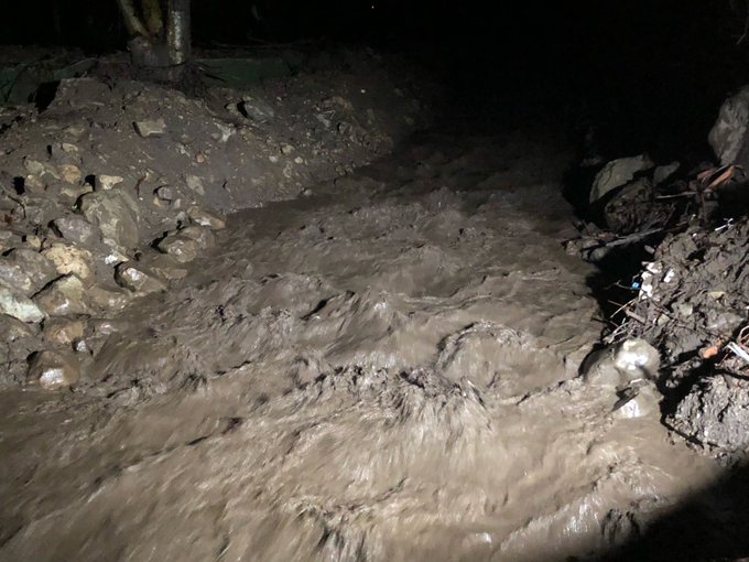
Montecito Creek near Olive Mill is flowing (photo credit Mike Eliason). Thanks go to all who worked to clean out our creeks and debris basins in preparation for this storm, allowing water and debris to be properly channeled.
#SantaBarbaraCounty
0
29
76
A voluntary evacuation warning has been issued for the Painted Cave community which includes the area north of Hwy 154 and south of East Camino Cielo along Painted Cave Road. If you are in this area, be prepared to leave.
#ThomasFire
2
81
76
If you are in a warning or mandatory evacuation area and need transportation assistance out of the area, call the Thomas Fire Community Call-in line at (805) 681-5542 or text (805) 729-6538 and state your specific need.
#ThomasFire
#SantaBarbaraCounty
0
116
74
Maintain situational awareness at beaches, harbors, marinas. Riptides likely. Tsunami is a series of successive surges of water that may be only a few feet in height yet still contain a massive amount of energy and can affect bays and inlets otherwise protected from ocean waves.
1
21
79
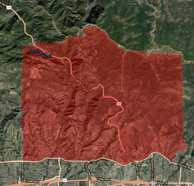
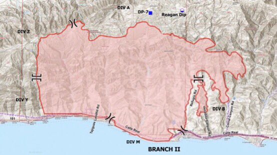
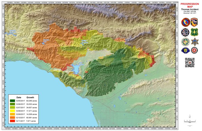
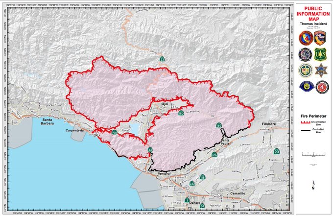
This map shows the progression of the
#ThomasFire
through last night. The fire grew yesterday by 7,671 acres.
4
90
72
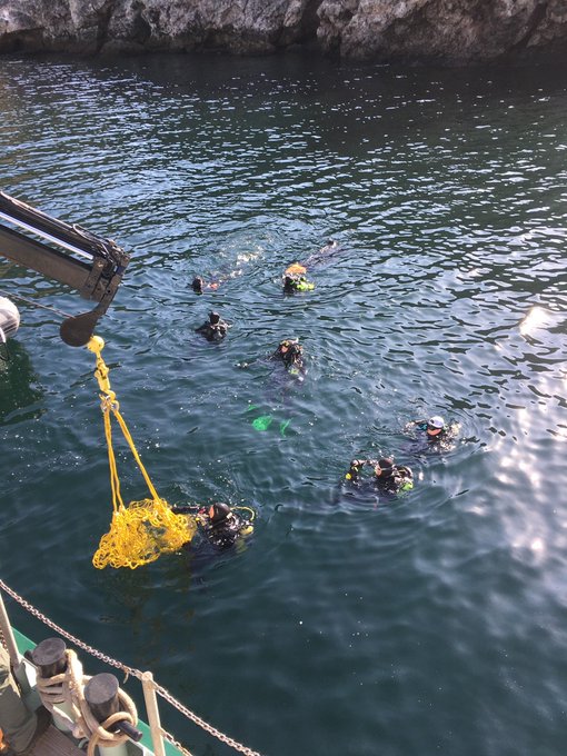
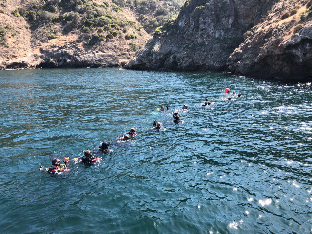
Divers and support crews from many agencies continue work at the
#Conception
dive boat incident off Santa Cruz Island. The vessel caught fire and sank on Monday, Sept. 2, 2019. Photos by
@sbsheriff
and
@CHISNPS
.
7
32
75
Here is today's morning update on the
#ThomasFire
. 272,000 acres burned and 60% contained.

#ThomasFire
[update] north of Santa Paula (Ventura and Santa Barbara County) is now 272,000 acres & 60% contained. Unified Command: CAL FIRE,
@VCFD_PIO
,
@LosPadresNF
,
@VenturaCityFD
, and Santa Barbara County Fire (
@EliasonMike
). …
8
129
248
0
40
76
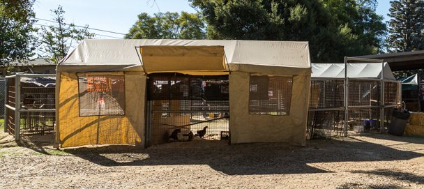
Don't leave your pets behind! There are many options for housing & care at no cost. Please call Santa Barbara County Animal Services hotline at 805-681-4332 for information about emergency housing for your animals or if you need emergency evacuation assistance.
#805strong
0
67
72
Rain storms are expected countywide Fri. Jan 13-Tues. Jan 17. High winds, localized flooding, poor road conditions, and dangerous surf conditions are expected. Residents should remain vigilant. More info & interactive incident map available at
2
34
76
Please be advised: The Los Padres National Forest is closed for 60 days due to storm damage.
2
28
75
A mudslide has been reported on Hwy 192 near Toro Canyon. Barricades in place and CHP responding. Residents in the area are able to pass by using a single lane. All homes in the area have been determined as safe. Exercise caution when driving on wet roads.
#SantaBarbaraCounty
4
44
71
URGENT: Hazardous situation. Vehicles are driving the wrong way on the Highway 101. Highly dangerous road conditions. Emergency service personnel are working quickly to clear roads. Please stay off the roads. Stay home and be safe.
#CAstorm
#SantaBarbaraCounty
2
98
70
#805strong
#COVID19
We can do this together. Please follow the state order to stay home except for essentials, like getting groceries, gas, food take-out, and pharmaceuticals. Continue to be diligent with washing your hands, get good sleep, go for a walk.
0
23
71
☀️Happy Sunday,
#SantaBarbaraCounty
! One area of our treasured coastline is the Gaviota Coast, a backdrop of rugged mountains, rolling hills, and lowland coastal areas. It is one of Southern California's largest remaining stretches of undeveloped coastline.
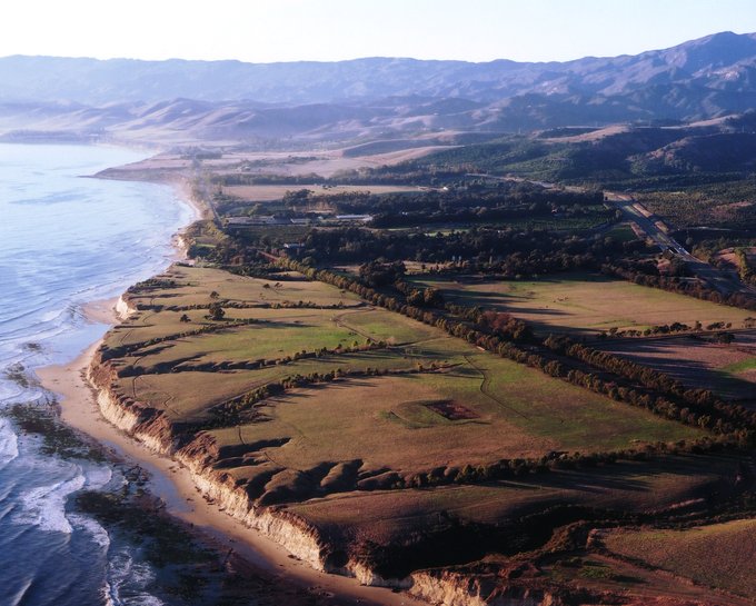
4
11
72
We are happy to see the community recognizing our first responders and recovery personnel.
#805Strong

#EllenDeGeneres
stopped to thank one of our officers working a road closure around the
#Montecito
area. She related that she appreciates what law enforcement has done to help with the
#MontecitoMudslide
.
#EllenDeGeneres
thank you for your support.
@CHP_HQ
@CHP_Coastal
@KEYTNC3

16
116
613
0
12
71
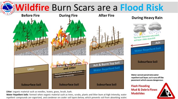
Please heed the warnings of authorities regarding the potential for flooding in the recent burn areas. See the infographic below from the National Weather Service explaining the risks to burn areas during a heavy rainstorm. Visit
#805strong
#CAstorm
0
56
70
Thank you
@kerrywashington
. Most people may not know or even noticed the WIC- women, infants & children acronym. Hoarding has made tough times even harder for our most vulnerable population. Yes, even in
#santabarbaracounty
.
#805strong

When stocking up for
#SocialDistancing
...If you see something labeled “WIC” please chose another brand. People who rely on WIC products to feed their kids cannot. We’re all in this together 🙏🏾

733
30K
73K
0
20
71
Stop hate. Stop violence. Be kind. Be patient. Be the solution. We stand with our colleagues and neighbors in
#VenturaCounty
today and always. Together, we are
#805strong
.

0
18
70
#ThomasFire
is burning completely in Ventura County southeast of Santa Barbara County. Currently there are no evacuation warnings or orders for
#SantaBarbaraCounty
. Fire officials are monitoring the situations. Please continue to stay alert to changes in conditions.
1
53
68
#CaveFire
& Weather News Alert: County & city public safety officials are preparing to release evacuation & incoming storm information. We request the community to monitor media and social media for this info tonight. Officials are working to release this information ASAP.
1
31
65
Tom Fayram, Deputy Director of the Santa Barbara County Flood Control District: "The catch basins were effective. The creek channels, roads were able to handle the rain and debris.” Picture taken this morning at from Toro Lower Basin.
#805strong
#ReadySBC
#SantaBarbaraCounty
3
24
66
Due to the
#cavefire
, an Evacuation WARNING is being issued for the area West of Hwy 154 to El Sueno, below Cathedral Oaks to Calle Real. Please remain alert and be prepared to evacuate if conditions change.
1
43
67
As of 6:15AM there have been no changes in evacuation orders compared to last night (12/17/2017). If we can't reach you, we can't alert you. Sign up today
#ThomasFire
0
54
63
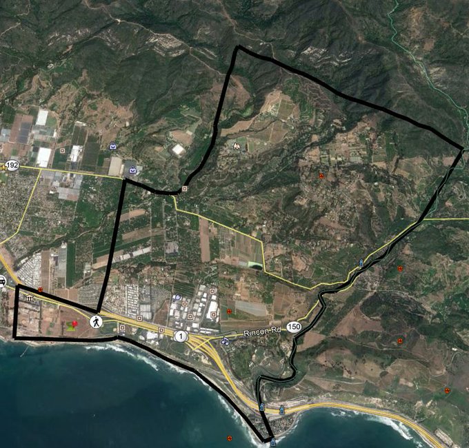
MANDATORY EVACUATION ORDER: Montecito and Summerland area north of Alameda Padre Sierra/South Salinas Street and Highway 101, south of 192, east of Mission Canyon Road, and west of Hot Springs/Summit Road. Residents should leave immediately.
#ThomasFire
#SantaBarbaraCounty
2
112
58
Recommended Evacuation Warning issued for communities near Thomas, Sherpa and Whittier fire burn areas in
#SantaBarbaraCounty
. Moderate to heavy rainfall Thursday into Friday may generate isolated mud and debris flows. Full details in our press release:
2
100
64
Overwhelming thanks & gratitude for
#SantaBarbaraCounty
staff, local partners, and regional/state first responders who come to all our aid through sun and heat turned into
#cavefire
, immediately followed by rain that raises fears for debris flows, and one day later- snow.


1
14
67
The US-101 southbound closure at Milpas Road and SR-150 were opened on 1/10/23, at 1:40 pm. CHP Ventura has opened US 101 southbound at SR-33.
The public can now travel south on US-101 through the Santa Barbara, Montecito, and Carpinteria areas into Ventura.
6
15
67
Full closure of HWY 166 from U.S. 101 near Santa Maria to HWY 33 along the Cuyama Hwy due to multiple rock and mud slides.
1
22
63

EFFECTIVE IMMEDIATELY: A new Mandatory Evacuation Order area declared for Montecito beginning at 6pm tonight. This area is west of Sheffield Dr/East Valley Rd/Ladera Ln, east of Olive Mill/Hot Spring Rd, north of the ocean, and south of the U.S. Forest Service boundary
#CAstorm
1
91
63
#holidayfire
Inside 805 area code, call 211, or text your zip code to 898211, or outside 805 area code, call toll-free 800-400-1572. .
4
86
57
Additional
#alamofire
evacuation orders for Pine Canyon and Buckhorn Ridge. Currently 19,000 acres burned, 10% contained.
0
65
56
STORM UPDATE: Higher intensity rainfall anticipated later Wed into Thur. Heaviest rain between 5 a.m. and 11 a.m. Thur, with the potential for 0.5 to 0.75 inches per hour in the foothills and mountains. See full release at
#805Strong
#CAStorm
0
56
59
Effective immediately (10:30 a.m. today, March 13), Mandatory Evacuation Orders are lifted for all areas. The decision was made by the Santa Barbara County Sheriff’s Office in consultation with the National Weather Service and other public safety officials.
#805Strong
2
53
62
USGS reported a 5.3 magnitude
#earthquake
(NWS Tsunami Warning Ctr reported 5.4) centered 35 miles SW of Channel Island Beach at 12:29 p.m. No reports of damage received by County dispatch. Tsunami Warnings have NOT been issued. If conditions change, we will update the community.
0
26
53
CHP will be continuing to monitor the approaching storm and road conditions. CHP will determine if public safety is at risk and if the HWY 101 needs to be closed. If closure is needed, shut down will occur without notice. HWY 101 remains open at this time.
#SantaBarbaraCounty
3
37
58