NWS Bay Area 🌉
@NWSBayArea
Followers
193K
Following
34K
Media
25K
Statuses
61K
Official Twitter account for the National Weather Service San Francisco Bay Area. Details: https://t.co/ASDrLwF1Yj
San Francisco, CA
Joined June 2012
San Francisco meteorological summer so far Jun 1-Jul 24, 2025 *avg temp* (avg of daily highs AND lows) 58.4F ties 23rd coolest for same period, coolest since 58.4F in 2002. Same reasons why as below except night hours with fog & low clouds reduce outgoing radiative cooling. #CAwx.
San Francisco meteorological summer (Jun-Aug) 2025 Jun 1-Jul 24 avg high 63.6F 16th coolest, coolest since 62.3F 1982. Reasons: East Pac sea surface cooler, NW winds, upwelling, upper lows, fog & low clouds (less incoming solar energy), drizzle, i.e. cooler air saturation. #CAwx.
8
5
32
RT @NWS_NTWC: Tsunami Info Stmt: M6.6 Samoa Islands Region 1638PDT Jul 24: Tsunami NOT expected; CA,OR,WA,BC,and AK.
0
84
0
San Francisco meteorological summer (Jun-Aug) 2025 Jun 1-Jul 24 avg high 63.6F 16th coolest, coolest since 62.3F 1982. Reasons: East Pac sea surface cooler, NW winds, upwelling, upper lows, fog & low clouds (less incoming solar energy), drizzle, i.e. cooler air saturation. #CAwx.
5
5
64
Late July 2025 Seasonal Outlook - Update. We'll talk about where we're at, what we've seen (and why), and where we're likely to go with the rest of summer and into the fire season.
0
2
9
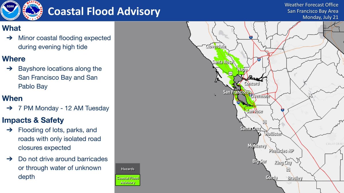
A Coastal Flood Advisory is in effect from 9PM Thursday through 2AM Friday for Bayshore locations along the San Francisco Bay and San Pablo Bay. Minor coastal flooding is expected during high tide tonight - do not drive around barricades or through water of unknown depth. #CAwx

2
8
14
RT @CAL_FIRE: 🔥 95% of wildfires are caused by people. That means almost every fire that has threatened communities could have been prevent….
0
35
0
Look familiar? Different coast and different mountains, but we see this happen all the time as stratus surges over our coastal mountain. Our atmosphere is a fluid. #cawx.

A timelapse showing 30 minutes worth of clouds flowing over Mt Adams and then Mt Washington after sunrise this morning (22 July 2025). #NHwx #NH #mountains #capcloud #timelapse
1
12
102
Low clouds across the region this Wednesday morning are quickly dissipating. Most areas across the region will see sunshine today, with the exception of the North Bay coast. Temperatures will be below seasonal averages as a trough remains off of the coast. #CAwx #BayAreaWX
2
6
35
Minor coastal flooding expected along the Bayshore from 9PM Wednesday through 2AM Thursday. Up to 1 foot inundation above ground level is possible in low-lying areas near shorelines and tidal waterways.

1
4
17
RT @Space_Station: When the lights go down in the city 🌌✨. At the stroke of midnight local time, @Astro_Ayers captured the dark expanse o….
0
108
0
Cloud iridescence. What's that? One of our meteorologists captured cloud iridescence over Monterey today. Iridescent clouds appear in altocu, cirrocu, & cirrus clouds! They're caused by diffraction as tiny water droplets/ice crystals scatter sunlight. #cawx #AtmosphericOptics

1
5
54
Did you know: Whenever you see breaking waves at the beach, there's a risk of rip currents? If at all possible, swim at beaches with lifeguards; if caught in a rip current, stay calm, call for help, and swim parallel to shore. Break the Grip of the Rip! #WeatherReady


1
7
34
Radar Update 3:53 PM - Did you happen to check out the radar📡 this afternoon? You'll notice a few radar returns just clipping N Napa county. The returns are a few high based virga showers passing by. #CAWX
0
1
29
Check out the maximum wind gusts (mph) since midnight across the Bay Area and East Bay. Notably, the Altamont Pass Raws site (elevation of 1436 ft) saw a peak gust of 50 mph at 7:12 AM. Winds will remain gusty through this evening before easing overnight. #CAwx


0
4
31
Larger than normal tidal swings will bring minor tidal flooding to the Bayshore over the next few evenings. Why? The combination of lunar perigee on July 20th and a new moon on July 24th.
0
11
35
⛅️The forecast for the upcoming week: Seasonably cool temperatures, morning clouds, and breezy afternoons and evenings. In other words, a typical summertime pattern. #CAwx

12
6
56
Tsunami NOT expected.
Tsunami Info Stmt: M6.1 070mi SE Sand Point, Alaska 1428AKDT Jul 20: Tsunami NOT expected.
2
6
51
An elevated fire weather threat exists for the East Bay Hills/Diablo Range through tonight due to dry daytime conditions and strong onshore winds. Winds will gust between 35 to 55 mph with the strongest gusts located in the vicinity of the Altamont Pass. #CAwx

1
8
31
⚠️Onshore flow increases later today leading to stronger winds. Winds will be strongest in the inland gaps/passes of the East Bay and the Delta Region. Wind gusts of 30-40 mph will be possible. Gusty winds will also increase fire weather concerns. #cawx
2
7
36