
Bryan Maxwell SW FL WX
@bryan_maxw46284
Followers
2K
Following
72K
Media
450
Statuses
7K
Hurricanes, thunderstorms, cold, snow, building stuff, brainstorming.
Joined August 2023
I know it's a long way out still, so it's way too early to call anything for sure, but nevertheless my gut feeling on this one is based on the idea that the atmosphere often tends to get stuck in repetitive patterns. Very few disturbances have even gotten into the central or

Wednesday AM EURO/GFS ensembles for October 24th on https://t.co/3cvwpvVJ22. Watching current far Atlantic wave likely make it into the Caribbean first... then try and organize. Many show eventual curve. Historically this makes most sense... especially with the fronts we have
9
4
59

Interesting and challenging final mission for me this morning in #Melissa processing sondes for the @NOAA_HurrHunter flight. Obviously Cuba and Jamaica had weakened the core significantly, but it now has a much larger wind field. Honestly the never ending small bumps are tougher
16
22
254


#Melissa has about 12 hours to strengthen again before a 2nd landfall in Cuba, but it may not due to how Jamaica ruined it's structure. It takes time for that to come back and it may not fully do that, also it will be facing more shear as it's closer to the trough/cold front.
7
27
193

Message from NHC from there latest advisory: "It should be noted that while Melissa's landfall intensity is among the strongest ever recorded in the Atlantic basin, it will take extensive post-analysis to determine exactly where it ranks among landfalling Atlantic hurricanes."
4
43
468
Just landed after an absolutely insane flight with @NOAA_HurrHunter into #Melissa just before landfall in #Jamaica. I was processing the dropsonde data before it went out. When I saw the 113 m/s (219 knots) just above the surface I couldn't believe it. My display only goes to 100
83
759
5K
Eye is getting smaller at landfall. This could be due to the increased friction with land. The barometric pressure might have actually just gone down even more. Why? Think about what would happen if you had a tub full of water in the back of your pickup truck while driving down
6
15
260
The Medical facility in Black River, Jamaica has sustained major damage from the first wave of the Eyewall. #Melissa
https://t.co/rjrYXg4j7c
20
99
430

HURRICANE MELISSA has officially made landfall between Savana-La-Mar and Black River, Jamaica as a category 5 hurricane with maximum sustained winds of 185mph and a minimum pressure of 892mb!
0
4
15
If we can agree that the raw data for hurricane Dorian was sufficient to support an official max sustained winds of 185 mph, then if we use the raw data from Melissa and apply it using the same algorithms, there is no valid argument to assign the same 185 mph MSW here. Melissa is

#Melissa is in all likelihood a 200 mph hurricane. GPS drop in the south eyewall observed a 219kt wind at ~250m elevation. #Jamaica
13
58
615
New highest instantaneous wind ever recorded by a sonde with a reading of 215kts (247mph), incredible 150m LL mean of 188kts (216mph). IMO this is probably a 190-195mph storm.

Almost unbelievable storm, getting this pressure with a non-pinhole eye is basically unprecedented for this basin.
2
27
129
This means that some places in Jamaica will likely y see wind gusts well over 200 mph! We cannot compare this to Andrew, Dorian, Milton, or any other landfalling hurricane we have ever witnessed before. There is a legitimate chance that Melissa could end up being just as strong
This dropsonde thru the south and southeast part of #Melissa’s eyewall is the most insane dropsonde I’ve ever seen. *Mean* winds in the lowest 150m of 188 knot/216 mph with gusts upwards of 219 knot/252 mph!! Absolutely scary and historic hurricane is headed into SW Jamaica
4
8
36


You know what’s crazy. If you flip Melissa upside down, it looks like a carbon copy of Haiyan ‘13. Wild
13
81
774

Honestly, this looks like something that one of the hurricane models would spit out if you gave it 150°F water.
3
11
130

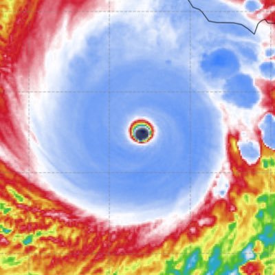
#Melissa's eye is still warming and drying, surrounded by an extremely intense band of convection. It isn't done yet.
0
5
21

This is the most violent rotation I’ve ever observed on a TC within the Atlantic basin on satellite. #Melissa’s rotating so fast that it’s become impossible to clearly track CDO cloud features on infrared even w 10-minute frames. Milton’s close but this is a straight buzz saw.
9
62
419
Standard protocol of reducing flight level winds down by 10% to deduce surface winds is garbage for these high-end cat 5's. Are people who have their houses destroyed by 200 mph winds supposed to feel better knowing that a few thousand feet above their heads the winds are only

Why the same reductions don’t work… Look how strong the winds are below flight level closer to the surface right now. It’s at a minimum a .94-.95 reduction I’d argue. The strongest storms(hurricanes) you’ll ever see are mixing down there winds so efficiently that they’re
1
3
16
https://t.co/B6saofhwiA Latest pass explicitly supporting this is at least 180-185mph
1
10
37