There is absolutely no obligation, none. But if you like and enjoy my weather content and want to say "thank you", or encourage me to develop more unique products, you can buy me a coffee @
Preliminary Snowfall Forecast for the upcoming Winter Storm
-Placement of heaviest snowfall likely to adjust
-highest confidence that
#GTA
will see heaviest snowfall
-Risk of mixing across parts of SW
#Ontario
and
#Niagara
We'll have a more detailed forecast tomorrow
#OnWX
Another ridiculously snowy run from the 🇪🇺 model!
It continues to show swath of 30+cm of snow across the
#GTA
with a max of 70+cm across
#Halton
Still think it's over done but becoming more likley that there will be a heavy swath of snow across S
#Ontario
..big ? Is where
#OnWX
The latest 🇨🇦 and 🇪🇺 models are showing 30-50+cm of snow for parts of the
#GTA
with the mid week storm....no thanks!
Good news is we are still 5 days away, so this will definitely change!
#OnWX
For all the winter lovers...
If this was snow, we'd be looking at a large swath of 100+cm that would have fallen in just a couple hours ❄️
#OnWX
#Onstorm
Big shift in the models overnight and it now looks like
#Toronto
and the
#GTA
will see 30+cm of snow between Wednesday and Friday!
Get those shovels ready!
#OnWX
Preliminary Snowfall Map for the upcoming Winter Storm.
*This was never supposed to be a big snow maker for the
#GTHA
.*
Heaviest snowfall expected across the snowbelts.
(This map includes lake effect amounts.)
I think this is a good start, will update as needed!
#OnWX
Very strong wording from the latest
@NWSBUFFALO
Area Forecast Discussion in regards to the upcoming winter storm.
"Paralyzing Lake Effect", "Explosive Cyclogenisis".
They also mentioned this storm to be described as a "Once in a generation type of event"!
#OnWX
The latest 🇨🇦 and 🇪🇺 models are showing 30-50+cm of snow for parts of the
#GTA
with the mid week storm....no thanks!
Good news is we are still 5 days away, so this will definitely change!
#OnWX
Sunday night into Monday is looking WET!
Slow moving low pressure system expected to slide through S
#Ontario
bringing with it a good, steady soaking!
Widespread 1" of rain with up to 2" possible across parts of SW Ont
More rain likley early next week.
#OnWX
#OntAg
It sure was a bright ride home this evening near
#Brussels
!
From heavy freezing rain/ ice pellets to summer like thunderstorms with a temperature of 0C all within a couple of hours...gotta love S
#Ontario
weather!
#OnWX
#Onstorm
SW
#Ontario
looks to be the sweet spot for snow on the latest GFS model.
Someone east of Lake
#Huron
might see up to 175cm og snow by January 27th (based on this run)
#OnWX
A Thread🧵
9 years ago, I started this page to track storms and converse with other weather enthusiasts. Fast forward to today, I continue tracking local and significant storm systems along with interacting with my audience of over 7000 people.
1/
Updated Snowfall Map for the upcoming Winter Storm
-Heaviest amounts along/ north of
#Hwy401
corridor from
#GTA
to E
#Ontario
-Mixing likely across N shore L
#Erie
and
#Niagara
-Still a good chance at seeing a south shift with snowfall
Will post a final update tonight!
#OnWX
Watching a larger storm threat for next Friday.
Wayyyy too early for any specifics other than models are showing a storm developing and moving through S
#Ontario
.
We'll post another update on Tuesday.
#OnWX
Final Snowfall Map for the upcoming storm.
If your area is circled in red, I'd strongly recommend postponing non- essential travel from Friday until Sunday.
For E.
#Ontario
, expect a round of snow tonight followed by a second round Friday PM.
#OnWX
Updated Snowfall map for the upcoming Storm.
Confidence has increased in a Lake Effect Snow Outbreak across the snow belts.
Will update this map one last time tomorrow if needed!
#OnWX
Watching Friday (March 3rd) very closley.
Models have been hinting at a large Winter Storm developing and potentially impacting S
#Ontario
.
We'll keep an eye on it and post an update on Tuesday!
#OnWX
Update on the upcoming Winter Storm 👇
-Confidence continues to increase on a large impactful storm impacting S
#Ontario
midweek
-Exact track TBD
This is our current thinking at precip types
We'll have an update posted tomorrow with a first shot at accumulations
#OnWX
Updated Snowfall Map for the Storm tomorrow into Wednesday👇
-Tough call for SW/ Central
#Ontario
and the
#GTA
as temps will play a big roll in total snowfall
-IP/ FZR may hinder snowfall as well
-Heaviest snow across N sections of S Ont
-Snow/ Icy Mix for E Ont
#OnWX
Watching the December 9th-11th time frame for a large storm to impact the region.
All models show a large storm impacting S
#Ontario
with each showing a very different scenario!
We will track...and update!
#OnWx
Chances are increasing for a powerful snowstorm to impact parts of S
#Ontario
Friday into Sunday.
Still lots of details to be ironed out (track/ intensity), but there continues to be strong model/ ensemble support
After tomorrow's storm, all focus shifts on the weekend.
#OnWX
Keeping an eye on February 12th/ 13th for our next chance at a wintry storm.
Decent agreement from the 🇺🇸 and 🇪🇺 models/ ensembles at storm impacting S
#Ontario
.
Still 8 days out, so lots can change...Will monitor and update later in the week.
#OnWX
Roads are a complete mess across
#Huron
and
#Perth
counties.
Strong winds are now causing significant blowing and drifting snow.
Plows are out but are struggling to keep up
#OnWx
#Onstorm
The Christmas Blizzard back in 2022 had a pressure of 974 when it was over
#Ontario
.
The latest GFS model for the Friday/ Saturday storm has a pressures of 961 near
#Windsor
!
*NOT A FORECAST*
#OnWX
Summers last hoorah next week?
After the cut off low moves out this weekend, a massive ridge is set to settle into Southern
#Ontario
!
With it comes well above normal temps, possibly several days near 30°C!
This ridge looks to stay parked until the middle of the month
#OnWX
Thousands without power across
#Toronto
, especially
#Etobicoke
.
Flood waters likely seeped into the underground electrical infrastructure, very similar to what occurred in 2013.
#OnWX
#Onstorm
When will we flip to a warmer pattern?
Watching a pattern change as we end off April and begin May
A ridge is expected to develop over the region, bringing widespread "above normal" temps to most of S
#Ontario
.
This pattern looks to continue well into May.
Will update!
#OnWX
Snowfall Map for the Lake Effect Event (Nov 26th to Nov 29th)👇
-Still uncertainty on placement of heaviest bands
-Highest snowfall likely across
#Grey
,
#Bruce
and northern
#Simcoe
/
#Muskoka
Counties
-Whiteout Conditions expected across rural areas
Will Update if needed!
#OnWX
Preliminary forecast for the Friday/ Saturday Storm
-Still some uncertainty on track/ strength
-Heaviest snowfall likely across SW
#Ontario
-Lk Enhancement *possible* for the
#GTA
-Less snow further NE
Amounts likely to change, we'll post a detailed forecast Wed PM
#OnWX
Last post for the day...its been a long one
Thanks for following along and welcome to all the new followers!
Similar weather expected tomorrow as the low slowly pulls away
Scattered showers/ storms expected throughout the day with localized significant rainfall possible
#OnWX
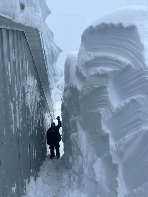
The last 10 days of November are starting to look very snowy ❄️ across the snowbelts.
Could see some hefty amounts I that period thanks to multiple systems/ Lake effect snow events.
Not a forecast by any means, but something to definitely keep an eye on!
#OnWX
Final forecast for the upcoming Winter Storm
-Big bust potential if temps are off by a degree or 2
-Ice Storm Risk
#Sarnia
-
#London
-
#Niagara
-Snowy/Icy mix for
#GTA
-Heavy Snow across C and E
#Ontario
If there's any big changes overnight we'll post an update in the AM
#OnWX
Still aways out, but the 🇨🇦 Model brings a sweltering heatwave to Southern
#Ontario
early next week.
Widespread temps in the low to mid 30s with overnight temps in the mid 20s for a couple days
Likely too bullish on the temps but the pattern sure supports it!
#OnWX
It honestly doesn't get much better than this set up right here....
Cold air being pumped in from the NW, ridge along the SE pumping in moisture... 💥... active storm track with S
#Ontario
in the sweet spot.
Fun times ahead tracking (likely) numerous large storms!
#OnWx
After tonight and tomorrow night, low temps will likely stay above freezing for the next 12 to 14 days across most of S
#Ontario
.
Daytime temps will range between 15°C to 25°C this week with no rain expected until at least Sunday!
#OnWX
Update on the weekend storm👇
-Heaviest snow likely across the
#Hwy401
corridor from
#Hamilton
to
#Cornwall
-Lake Enhancement near
#GTA
likley to boost totals locally
-Brief light snow + flurries for the rest of S
#Ontario
Will Update
#OnWX
Drive home from
#Listowel
was trecherous with blowing/ drifting snow causing near whiteout conditions.
Highway was also heavily drifted and ice packed.
#OnWX
#Onstorm
Snowfall forecast for the expected Lake Effect Snow Outbreak👇
-Amounts are valid from Saturday to Sunday PM
-Hardest hit areas
#Huron
,
#Perth
,
#Grey
,
#Bruce
,
#Wellington
,
#Muskoka
-Travel will be difficult tonight/ tomorrow
-Strong winds will create whiteouts at times
#onWX
Preliminary Snowfall Map for the April 3rd-5th storm👇
-Highest Snowfall across higher elevations/ parts of E
#Ontario
(3)
-Sloppy mix near
#Hwy401
and south (1)
-Up to 10cm elsewhere
-Still some uncertainty on exact track/ strength of the storm
Will update tomorrow!
#OnWX
Preliminary Snowfall Map for the upcoming Winter Storm
-Heaviest snow likely around the
#HWY401
corridor
-Mixing/ marginal temps might lower snowfall amounts across the
#Niagara
Region
-Lake Enhancement *possible* across the west
#GTHA
Will update this map tomorrow
#OnWX
The country corn stands are starting to pop up across the counties, and the crop this year is looking great!
Great tasting corn and supporting local farmers = a win win!
#OntAg
A possible tornado has touched down in the Greenfield Road/Northumberland Road area of Ayr. Please note that the NDCC and Cowan Park are CLOSED. We ask that people stay away from the area of Greenfield/Northumberland as emergency crews are on site. (photo from Jake Nagle)
Preliminary Forecast for the Midweek Winter Storm (Valid Wednesday AM to Friday AM)
-Ice Storm for parts of SW
#Ontario
-10-20cm of snow/IP for the
#GTA
-15-30cm for most of C and E Ont
We'll post an updated forecast tomorrow if needed!
#OnWX
What looked to be a 🔥 end to November is now looking 🥶!
Watching a pattern change that may bring widespread cold and possible snow to S
#Ontario
the last week of November and into December
Strong model/ ensemble support, but we'll keep an eye on it and update next week
#OnWX
From 🔥 to 🥶 (literally)!
Watching the middle of October for a pattern change to cooler than normal temperatures and maybe the first ❄️ flakes!
Risk of the first widespread frost/ freeze of the season
We'll keep an eye on it and post an update as we near closer
#OnWX
#OntAg
Final Snowfall Forecast for tomorrow
-Heaviest snowfall likely across the
#GTA
and
#Hwy401
corridor
-Bust potential near Lk
#Ontario
if mixing occurs
-N Shore Lk
#Erie
still in question due to exact track
-Less snow further N/NE
Will update in the AM if needed!
#OnWX
Closely watching Friday for a widespread severe weather risk across S
#Ontario
Models are pointing towards several rounds of thunderstorms in the afternoon with the potential of a large squall line
Will have to wait until mesocale models come into range for more details
#OnWX
Next system arrives Monday PM.
Looks like another snow maker with the risk of rain/ mix across parts of SW
#Ontario
.
We'll have an update on this one later today.
#OnWX
Long Range Update 👇
-Mild/ drier pattern looks to continue into the first half of February
-Not a torch by any means!
-Watching mid February (~15th onward) for the return of a colder/ snowier pattern
Will monitor and update!
#OnWX
One word to describe the weather next week....SPECTACULAR!
Temperatures will range between 15°C to 20°C beginning Monday and lasting until Sunday with little to no precip expected.
Some areas may even crack the 25°C mark!
#OnWX
Updated Snowfall Map for the Upcoming Winter Storm
-Bust potential across the
#GTHA
and
#Niagara
due to mixing potential
-If no mixing/dry slot, 25+cm very possible red hatched area
-15+cm for most of SW
#Ontario
and E Ont
Will update this map tomorrow morning if needed!
#OnWX
Update on the weekend storm👇
-Heaviest snow likely across the
#Hwy401
corridor from
#Hamilton
to
#Cornwall
-Lake Enhancement near
#GTA
likley to boost totals locally
-Brief light snow + flurries for the rest of S
#Ontario
Will Update
#OnWX
Updated Thunderstorm Outlook for tomorrow 👇
Timing- Late afternoon/ Early PM
Zone 1-Heavy rain, small hail, gusty winds
Zone 2- Heavy rain, large hail 1-3cm, winds 70-90km
Zone 3- Heavy Rain, large hail 2-6cm, winds 80-100+km, tornado possible
#OnWX
Updated Forecast for the upcoming Winter Storm
-Overnight models continued with the slight northward shift of the storm
-Worst of the Ice Storm from
#Sarnia
-
#London
-
#Niagara
-Icy Mix for
#GTA
-Snowstorm for most of E
#Ontario
Will post a final update this evening!
#OnWX
Increasing odds of severe thunderstorms across parts of S
#Ontario
on Wednesday.
Most of the region now under a "slight risk" of severe storms (thats a pretty big deal 3 days away).
We'll have an update either later today or tomorrow AM.
#OnWX
Another large spring storm will impact S
#Ontario
on Wednesday.
This storm is expected to be stronger and track further north, bringing the severe storm risk further north.
The
@NOAA
SPC has already highlighted most of S Ont in their Day 4 Outlook for severe storms
#OnWX