

Michigan Storm Chasers
@MiStormChasers
Followers
3,311
Following
157
Media
619
Statuses
1,442
Providing the Great Lake State with accurate forecasts, live chasing, and disaster relief. For business inquiries contact MIStormChasers @gmail .com
Michigan, USA
Joined May 2021
Don't wanna be here?
Send us removal request.
Explore trending content on Musk Viewer
Mother's Day
• 1199583 Tweets
Mauro
• 143323 Tweets
Emma
• 67324 Tweets
Nuggets
• 63185 Tweets
#DebateChilango
• 60949 Tweets
Wolves
• 45568 Tweets
Juliana
• 35474 Tweets
Denver
• 33104 Tweets
Sebastián
• 30403 Tweets
Jokic
• 29331 Tweets
Iztapalapa
• 29024 Tweets
Clara Brugada
• 26702 Tweets
Minnesota
• 25464 Tweets
つばさの党
• 25448 Tweets
Jamal Murray
• 24382 Tweets
BIRTH Campaign
• 23328 Tweets
Bruins
• 22340 Tweets
Cruz Azul
• 21274 Tweets
Pumas
• 20635 Tweets
Fabra
• 19993 Tweets
Bennett
• 18757 Tweets
Panthers
• 18600 Tweets
Medina
• 16255 Tweets
Benito Juárez
• 16003 Tweets
Gobert
• 14913 Tweets
家宅捜索
• 12885 Tweets
Tigres
• 12636 Tweets
政治団体
• 12457 Tweets
衆院東京15区
• 11741 Tweets


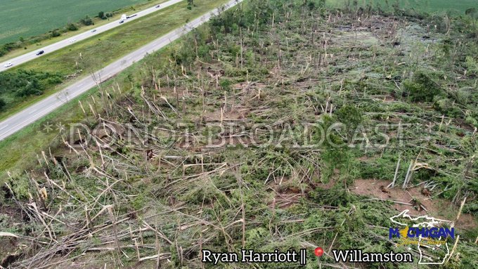
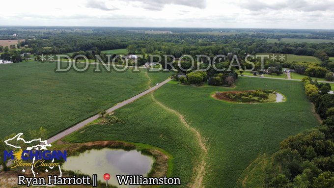
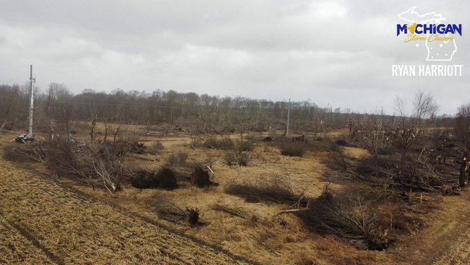
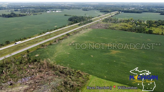
INCREDIBLE drone video of the Williamston/Webberville tornado path through the fields with ground scouring evident along I-96. More pictures to come.
🎥-MSC Ryan Harriott
@RyanWx_
@ReedTimmerAccu
@NWSDetroit
@NWSGrandRapids
16
190
681
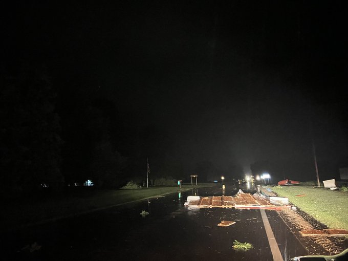
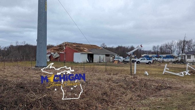
FIRST LOOK: What appears to be warehouse damage and power lines down in Grand Blanc. Courtesy of Austin Erwin.
#miwx
24
67
179
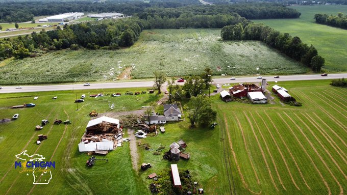
Some of the most intense damage found here in northeast Calhoun county. Outbuildings completely demolished, debris scattered through the woods, barns with roofs torn off, houses with minor damage. The trees in the woods snapped.
🎥 MSC / Ryan Harriott
@RyanWx_
@ReedTimmerUSA
…
2
42
174
ADDITIONAL: Video from Williamston and Webberville along I-96. The entire wooded section has been snapped in half. Not one tree stands.
🎥 MSC - Ryan Harriott
@ReedTimmerAccu
@RyanWx_
@NWSDetroit
@NWSGrandRapids
5
64
171
Do you know the difference between a shelf cloud and a wall cloud? It’s important! Because only a wall cloud can produce tornadoes and shelf clouds can’t! These two types of clouds are often mistaken for each other. So which cloud feature below is a shelf cloud and which is a…
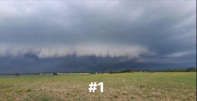
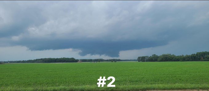
31
22
163
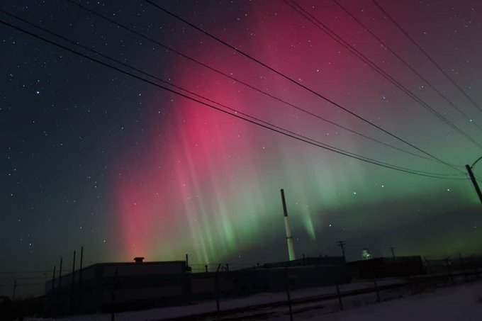
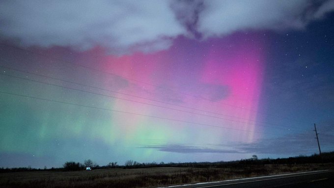
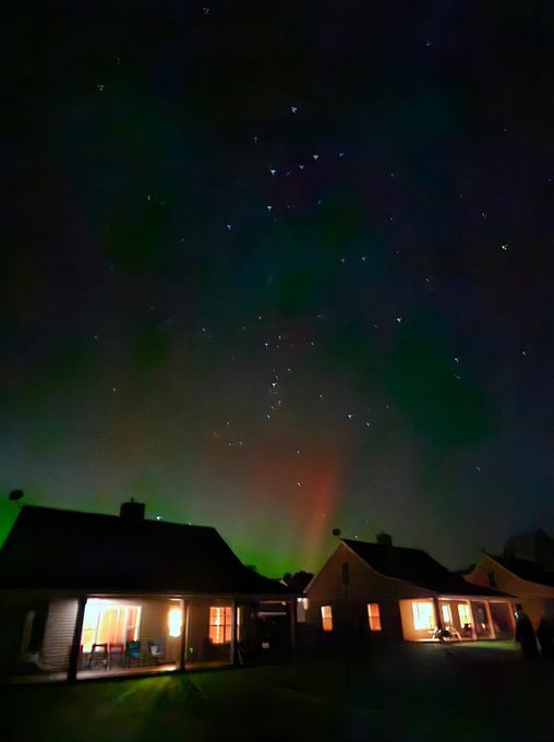
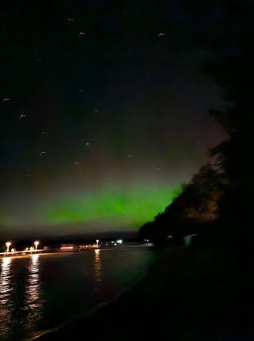
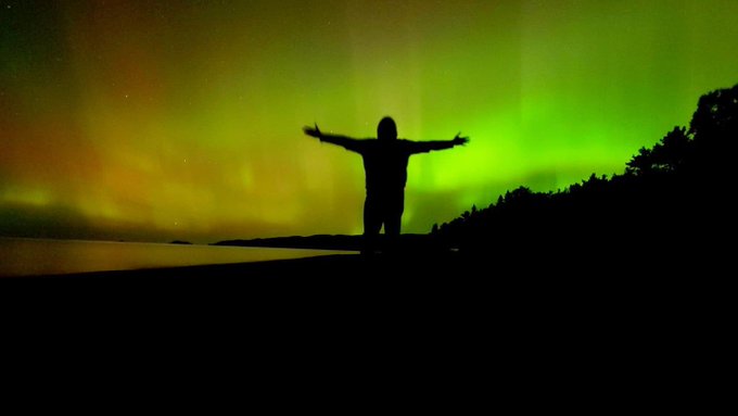
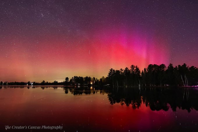
The Aurora went NUTS after we all went to bed. A second ejection shockwave was noted on satellites roughly after 3:00am with northern lights reports as far south as Battle Creek! Simply incredible!
Thank you to Denise for this photo!
📸 Denise Michelle 📍 Omer, MI
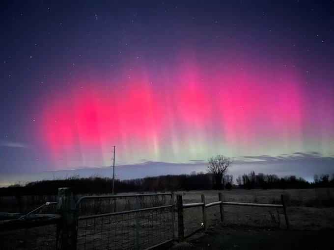
4
35
159
Let’s have a serious conversation about this weekend. We suggest you read through this discussion in its entirety.
Key points:
•Heavy snow at times
•Winds are a concern gusting up to 45-50mph
•Blizzard conditions likely
•Power outages possible
•Major drifting of…
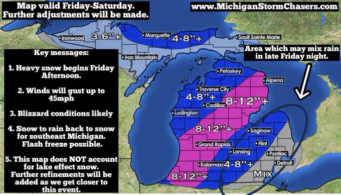
10
35
138
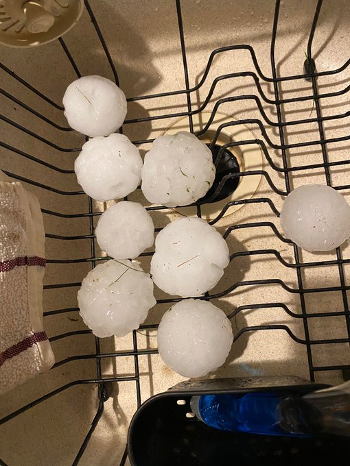
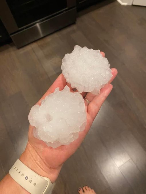
Madelynne Nye sent us these pictures of hail stones in Davison moments ago!
This looks to be tennis ball sized!
@NWSDetroit
3
35
136
“The
@lions
will win a playoff game when hell freezes over”
The current wind chill temperature in Detroit is -25.
🎤 ⬇️
4
22
129
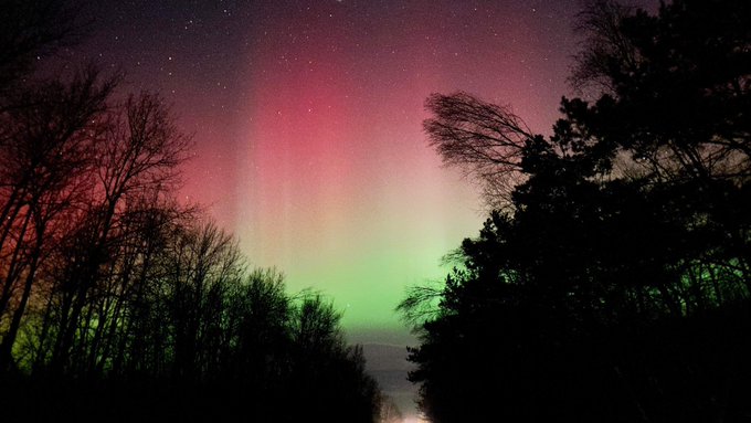
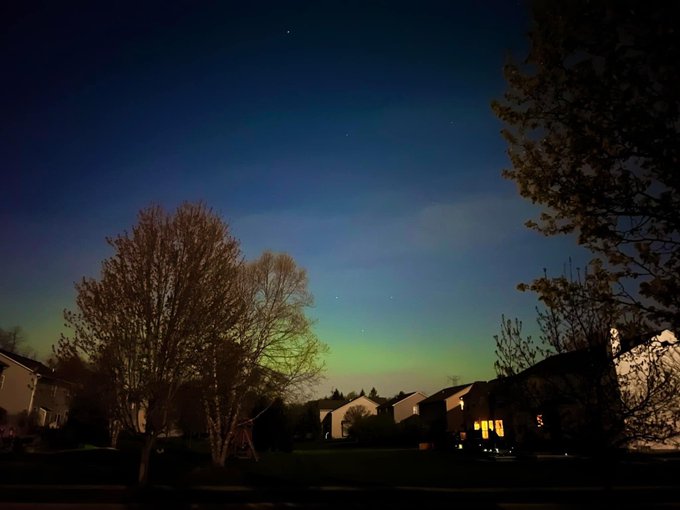
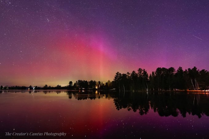
Michigan FINALLY checking in with GORGEOUS AURORA!
12/1 8:30pm
Credit:
📸 Jackie Sauer📍 White Pine
@AuroraNotify
@TamithaSkov
0
19
116
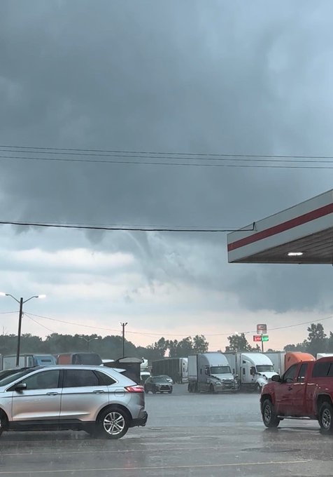
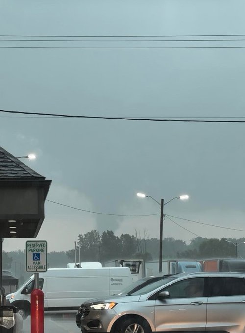
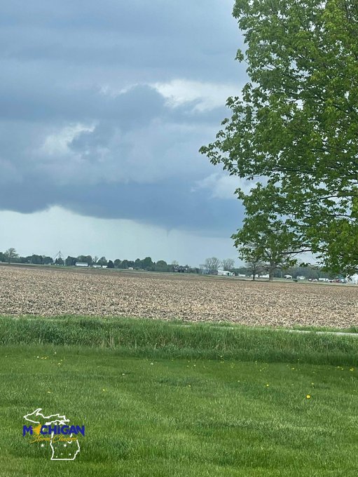
INCREDIBLE video of the now confirmed EF-0 tornado near Stockbridge from Wednesday’s storms!
Video courtesy to Samantha Moline
**DO NOT BROADCAST**
@ReedTimmerAccu
@StormHour
@NWSGrandRapids
1
26
105
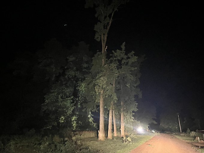
The entire wooded areas next to I-96 between Webberville and Williamston has been snapped. Not one tree stands.
@RyanWx_
@NWSDetroit
@NWSGrandRapids
@ReedTimmerAccu
2
33
100
THUNDERSNOWWWWWW!
Thank you to Cheryl from Royal Oak for sending this in to us!
📸 Cheryl Edberg 📍 Royal Oak
5
22
100
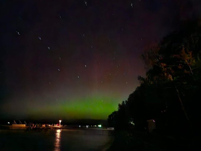
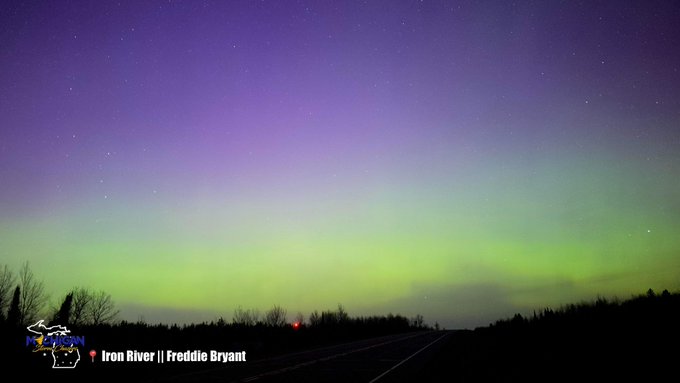
Sent into us from Freddie, who’s sitting near Duluth! 😍
8:38pm eastern
📸 Freddie Bryant📍 Duluth MN
@AuroraNotify
@TamithaSkov
1
17
98
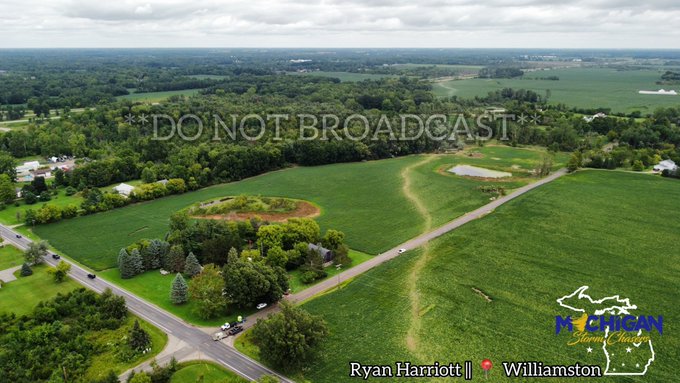
First image looking SW and second image looking NE towards 96, south of Willamston. Drill bit tornado with ground scouring before widening out and weakening slightly further east.
@RyanWx_
@ReedTimmerAccu
@NWSGrandRapids
@NWSDetroit
3
33
99
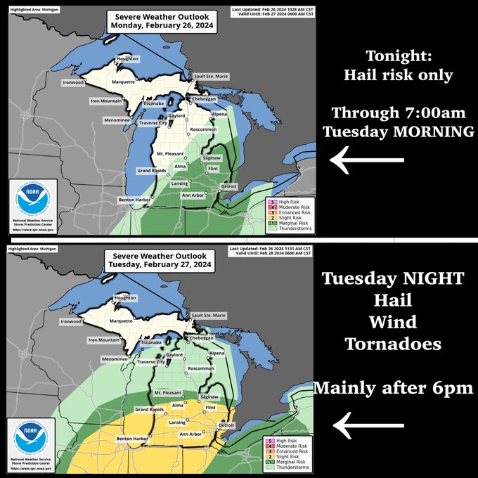
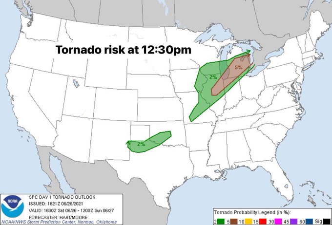
Severe weather concerns increasing for tomorrow!
Simple breakdown of what we have going on.
Morning showers and storms may be ongoing across central and southern Michigan. These are expected to move out and allow for atmospheric destabilization to occur. In addition, this line…
10
28
95
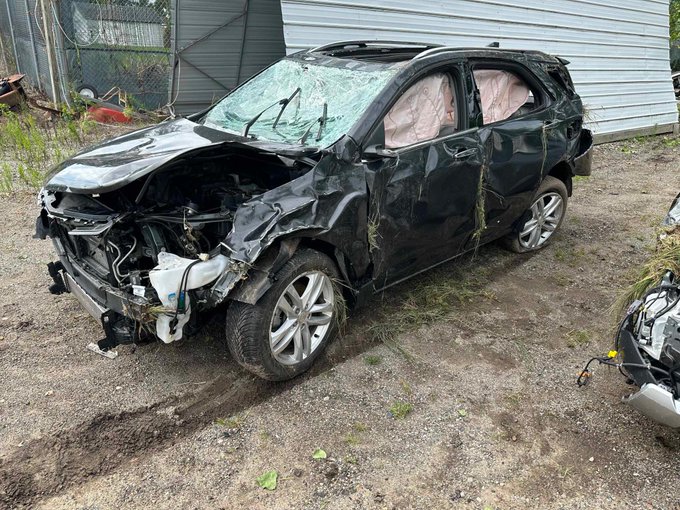
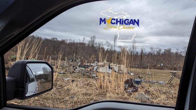
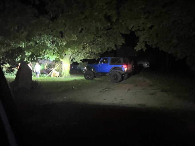
Lee Williams was one of the drivers traveling on I-96 at the time of the Webberville tornado. His vehicle was picked up and tossed into the median, rolling and spinning several times. He is lucky to walk away with only minor injuries.
Thank you to Lee for allowing us to share a…
9
19
93
Insane structure this morning in Northern Michigan!
2
22
87
Roofs torn off barns, sheet metal thrown, corn field flattened south of I96 south of Webberville along the tornado path.
📸MSC-Ryan Harriott
@RyanWx_
4
34
82
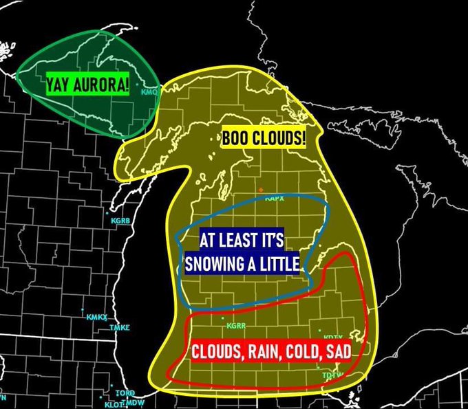
UPDATE: The SWPC has now upgraded our solar storm watch for Sunday evening to a G2/ KP6.
This means Aurora may be visible in all of Michigan!
3
16
78
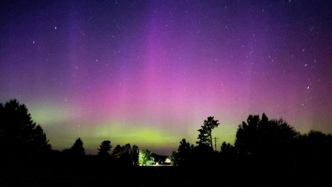
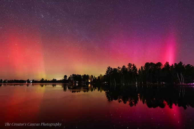
Check out these insane colors and faint pillars of Aurora a few minutes ago near Gaylord!
📸-Freddie Bryant
@AuroraNotify
2
15
77

The Michigan Storm Chasers are excited to announce our partnership!
We are the official provider for storm chasing footage to WOODTV!
We are thrilled to have the opportunity to cover severe weather events in West Michigan. Our mission has always been to keep everyone informed…
3
9
67
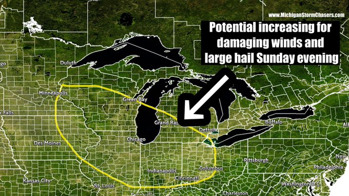
We are monitoring the potential for severe storms Sunday evening into the Monday morning hours. Strong instability is expected to develop out in Iowa/Illinois coupled with sufficient wind shear to form organized updrafts. Storms should be able to fire up and congeal into a…
4
23
64
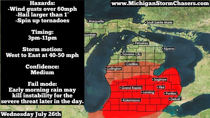
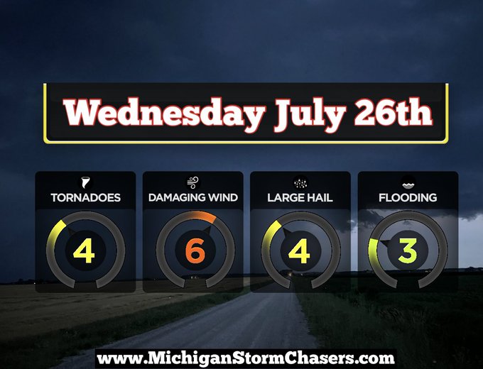
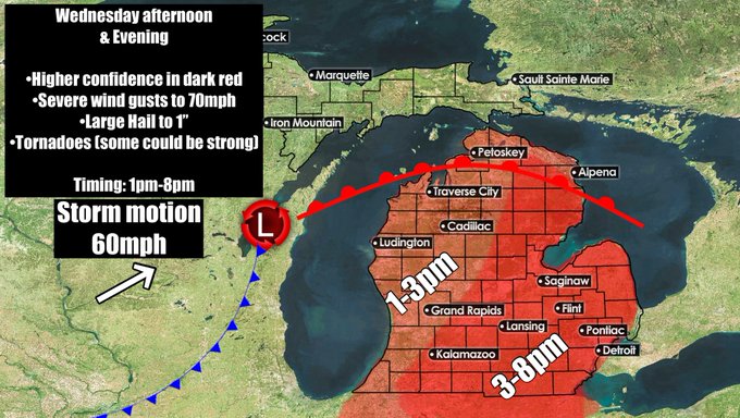
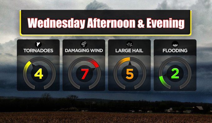
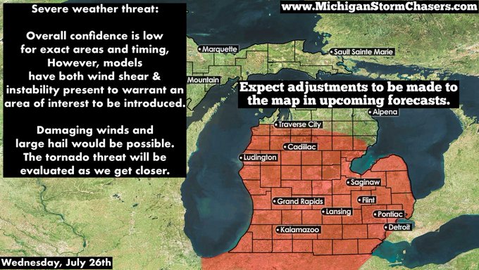
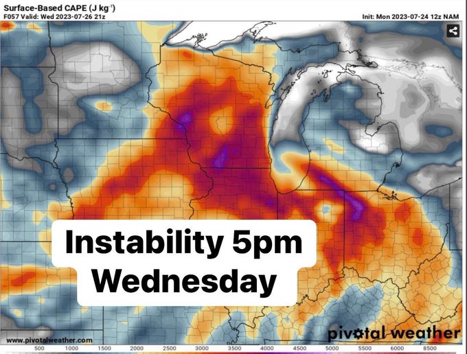
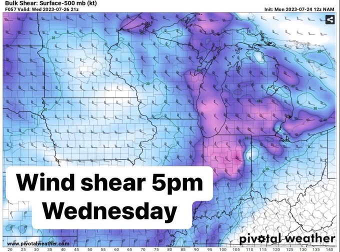
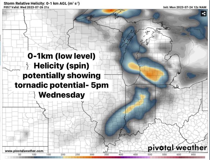
*Potential dangerous Severe Weather on Wednesday*
We are tracking a significant low pressure system on tap for Wednesday. High temperatures will be in the upper 60s and low 70s for most of lower Michigan.
The overview:
A warm front will lift north Tuesday night and a cold…
6
26
65
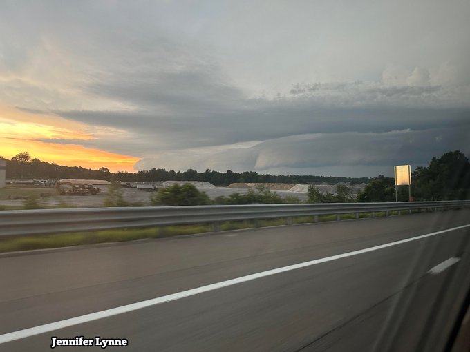
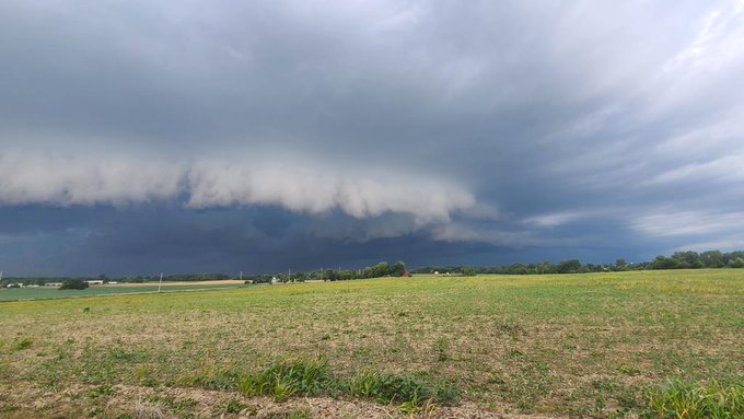
Shelf cloud meandering across southeast Michigan moments ago! Credit to
@RyanWx_
Taken in NE Lenawee county 6:30pm
@NWSDetroit
@ReedTimmerUSA
@GreatLakesSCN
3
12
66
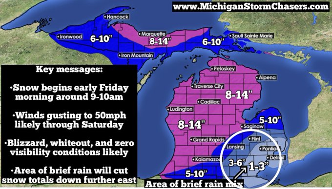
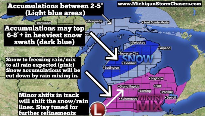
SIGNIFICANT SNOW & WIND EXPECTED:
Not much has changed with overall thinking.
TIMING: Snow will begin first the further south and west you are. Expect first flakes from 9am onward spreading north and east through the morning/early afternoon. Heavy snow will encompass the…
2
19
65
*PLEASE READ DISCUSSION FOR FULL DETAILS*
At long last, we get specific on the system starting Tuesday morning. Please be sure to like this post and if you find it helpful, consider sharing it. Thank you!
OVERALL DISCUSSION & DISCLAIMERS
1. Minor shifting of the track will…
6
14
64
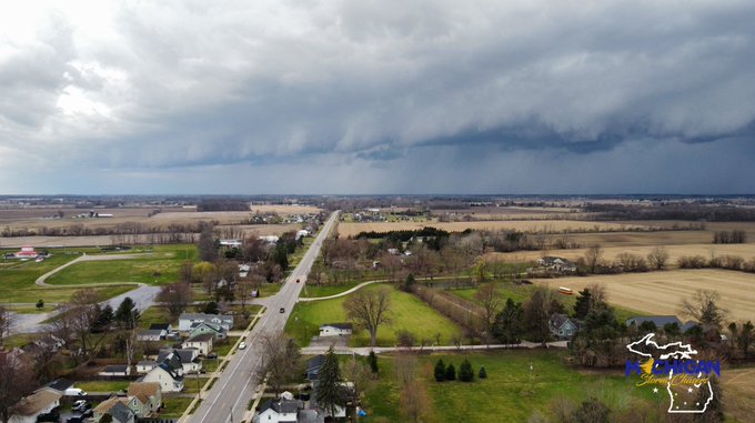
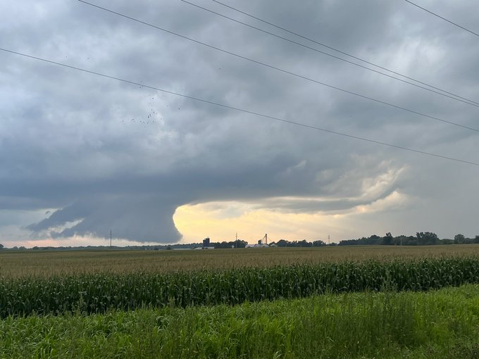
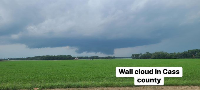
Giant wall cloud on the Jackson storm with broad rotation
From MSC staff
@RyanWx_
@NWSGrandRapids
2
10
61
We were just sent this picture of what appears to be a cold air funnel cloud near Fowler!
These type of funnel clouds are not tornadic related. They are usually harmless and RARELY ever touch ground. If they do, they can cause weak winds (50mph or so)
Let us know if you see…
1
17
60
Wow! Check out this intense swath of trees snapped halfway up the trunks in rural Calhoun County near Marshall, MI. Older and water logged trees are completely uprooted and high voltage wires were impacted at this location.
#miwx
@NWSGrandRapids
1
13
58
Damage pictures starting to trickle in. These photos were taken in NE Calhoun county/Near Marshall by Jarod Sweet.
@NWSGrandRapids
Exact location is unknown.
Areas include 19 mile, 20 mile, and 20 1/2 mile roads.
0
24
56
ADDITIONAL: On the ground pass by of one of the hardest hit areas along the Webberville tornado path.
@RyanWx_
@ReedTimmerAccu
2
17
56
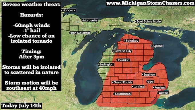
Tomorrow, we are anticipating a severe weather threat to develop here in Michigan.
WHAT:
A low pressure system will swing a cold front through the state tomorrow evening. A warm and moist airmass will be in place through the afternoon. The combination of colliding air masses…
4
11
56
Update regarding tomorrow’s severe threat.
Not much has changed with our thinking for tomorrow. The entire lower peninsula is under the risk for severe storms. This threat WILL BE LOW. Currently level 1 of 5 or known as a “marginal” risk.
You will not need to hold off or…
1
14
53
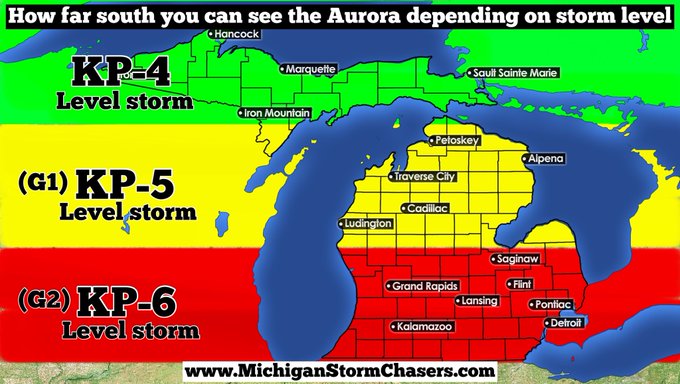
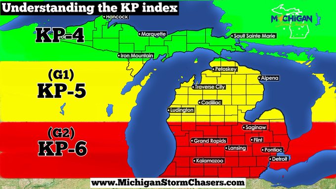
Understanding the “KP” index.
KP is a tool we use to communicate how strong Aurora is, and how far south it is reaching! It ranges on a scale of 0-9 with 0 being the weakest and 9 being the strongest.
Typically to see Aurora in Michigan, we need a KP4, which translates to the…
4
13
57
Ground scouring evident along I-96 between Williamston and Webberville for a very short length. Evidence of a powerful tornado. More to come shortly.
🎥 MSC- Ryan Harriott
@RyanWx_
@ReedTimmerAccu
@NWSDetroit
@NWSGrandRapids
0
19
55
Check out this INSANE slow mo lightning shot from Holland!
#miwx
Thank you to Haley Bolthouse for use!
@ellenbacca
@NWSGrandRapids
@StormHour
4
14
50
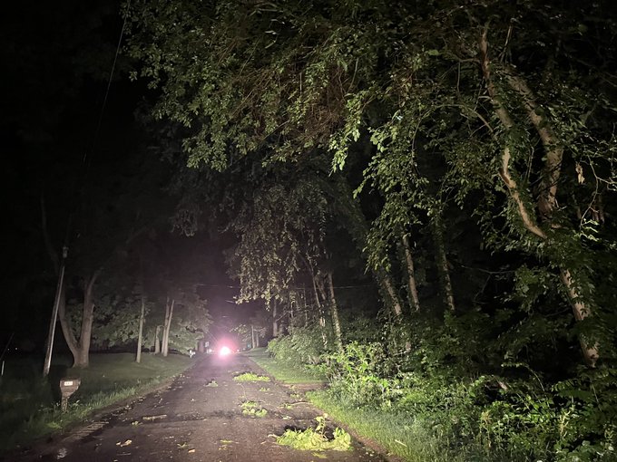
Very ominous video showing a lowering over the town of Lawton last night where rotation did try to tighten up. Some reports of tree and powerline damage in the area. Video taken on 28th st near Lawton.
#miwx
@NWSGrandRapids
@ellenbacca
@wxblakeharms
0
12
52
Everything you need to know about the upcoming potential storm system:
There is A LOT of hype surrounding this system that is showing up on the mid to long range models. You’ll likely start seeing this on your timelines if you haven’t already. The gist of the hype is a very…
2
12
50
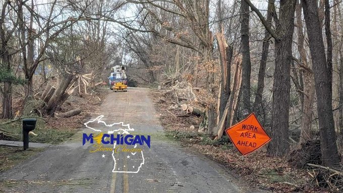
📍 Video in downtown Dundee showing what appears to be tornado damage from storms this morning. Crews are on scene cleaning up the area. Please give them space to work.
#MIwx
@NWSDetroit
2
15
46
**Significant severe weather possible today**
OVERVIEW:
Today is shaping up to potentially be one of Michigan’s busiest severe weather days. We have a slight risk in effect from the SPC with the mention of an enhanced upgrade possible. Within the slight risk, a 15% hatched area…
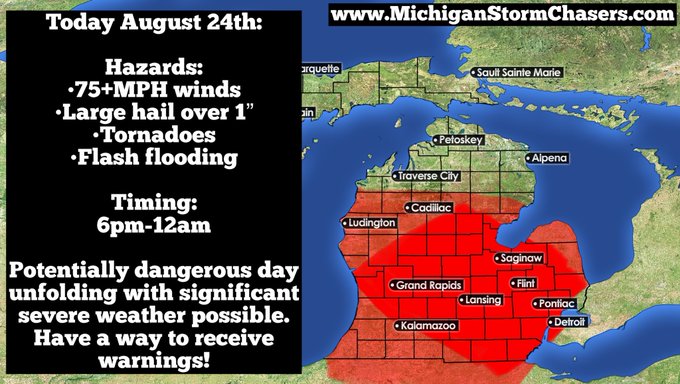
4
18
47
No change in the forecast at this time. Confidence of storm development remains uncertain. There is potential to see an organized squall line move through the state late this evening/overnight. Confidence is low in terms of exact placement of this potential squall line, but…
3
11
48
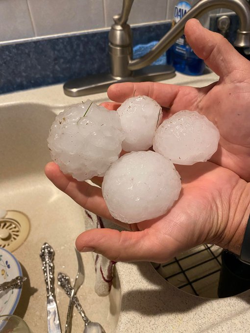
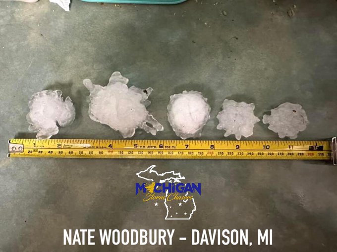
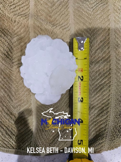
With permission from Nate Woodbury and Kelsea Beth out of Davison, MI, we were able to share these what appear to be 3-inch hail stones that fell today in the city with you all! The SPC storm reports page indicates 2.75” hail fell across the area, but it appears we’ve just found…
4
14
47
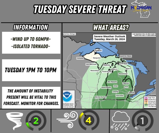
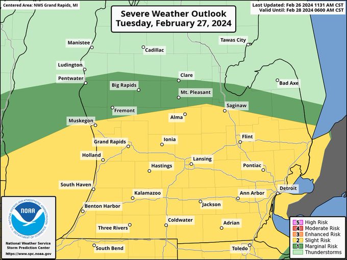
TUESDAY SEVERE RISK:
Our personal thoughts:
We usually make our own forecast map with our own risk areas, but today we are going with a different approach to avoid confusion between different sources.
The SPC has a slight risk (level 2 of 5 in yellow) and a marginal risk…
2
21
47
A look at some of the worst tornadic damage in Calhoun county near Marshall.
🎥 MSC- Ryan Harriott
@RyanWx_
2
19
47
Illinois just had a TORNADO on the ground, caught by our partner chaser
@glwx_
!
It appeared to be weak and was not fully condensed. If you look underneath the lowering you can see the dust swirl as well as the cloud base rotating! Great footage from Ben!
#ilwx
@NWSQuadCities
2
10
47
Partner chaser
@WXChaserCody
took these photos from his dashcam of what we believe to be the Marshall, MI tornado. His location at the time was I-94 eastbound approaching the I-69 corridor. (Verona road overpass ahead in the pic)
#miwx
@NWSGrandRapids
@ReedTimmerUSA
1
13
46
There are TWO distinct severe risks with different timings & hazards.
Threat 1.
Tonight for southern and eastern lower Michigan, there is a threat for elevated storms to produce large hail. This will happen overnight between midnight and 7am. No tornado or wind risk is expected…
1
17
46
WATERSPOUT! A waterspout occured right before reaching the shore of Lake Michigan! All of this with snow on the ground! A fantastic catch from Ben!
🎥 MSCPN:
@glwx_
📍Warren Dunes
2
8
45
We couldn’t be too far off from the truth right?
5
15
44
Severe weather discussion for Wednesday
DISCUSSION:
This week was going to be a little tricky in pinpointing exact days and timing. The overall pattern we are in is a typical summer time pattern where storm systems can creep up very quickly. This was the case with Wednesday.…
3
9
42
Being that we are three days away from this setup, we do have some uncertainty with exact timing and also the specific hazards. But enough confidence and consistency in models warrants a breakdown.
A weak low pressure system pushes in Thursday morning and by early Friday, a cold…
3
16
43
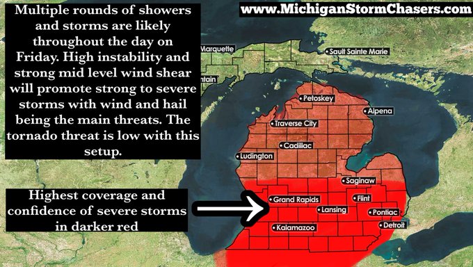
Severe weather possible tomorrow:
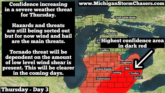
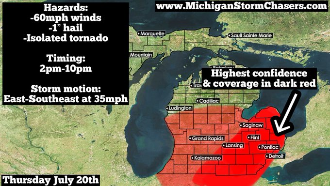
A cold front will push through Michigan tomorrow sparking scattered to widespread storms across the lower peninsula. Highest confidence of severe weather and coverage of storms will be in the darker shaded red area from the thumb all the way…
2
16
42
With essentially every news station and even national news hyping up the Aurora forecast for this Thursday, we’d like to again remind everyone this story is MISLEADING and completely irresponsible. The forecast stating that Aurora would be visible in 17 states was based off a…
4
6
42
As mentioned, we will need to watch Sunday as a low pressure system will drape a warm front across southern Michigan. This will be the focus for atmospheric destabilization and storm trigger.
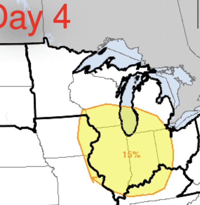
The SPC has just released their Day 4 outlook and it includes southern/southwestern…
5
8
41
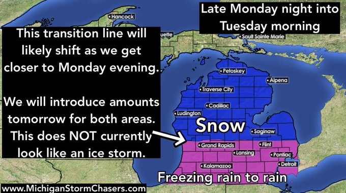
Hey everyone, this is a first forecast map for the Monday night into Tuesday system.
Right now freezing rain looks likely for areas along and south of I-94. This will begin late tomorrow night and last overnight into Tuesday morning.
Further north, mostly snow is expected…
6
8
41
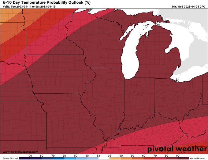
Looking at the long term models, we’ll be in the 50s and 60s through the end of this week and by Monday into next week, we will be in the upper 60s and 70s. Some days we may make a run at 80 degrees!
Who is ready for WARMTH?
#MIwx
Graphic below is the 6-10 day temperature…
6
5
38
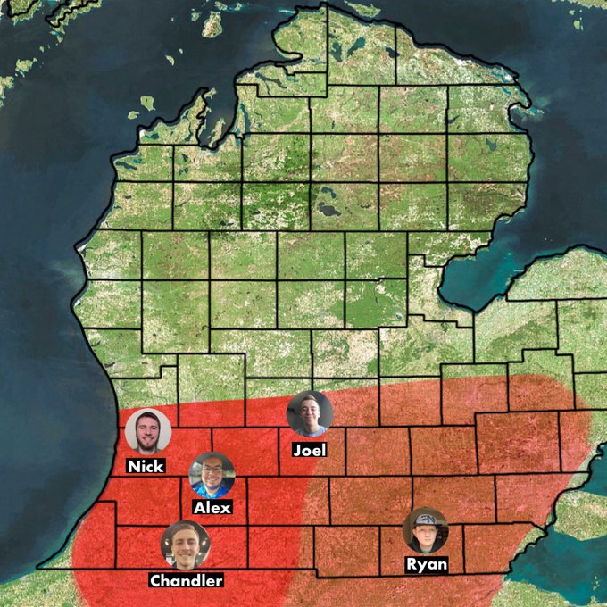
Our chasers are active in the field this evening as severe weather threatens. We will keep you updated and if it warrants, we will be live!
#miwx
@cjbos1
@Scraft_wxman
@Joel_Fritsma
@Lemons_Visser
@RyanWx_
8
10
39
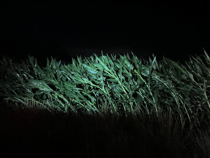
Flipped vehicles and slide offs are occurring this afternoon across west Michigan as dangerous road conditions continue into the afternoon. PLEASE SLOW DOWN!
🎥 MSCPN: Drew Brummel 📍 Twin Lake
3
15
41
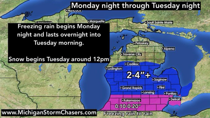
*Freezing rain potential Monday night into Tuesday morning*
Models are converging on a messy system headed our way arriving Monday afternoon and lasting through the night into Tuesday morning.
Initial thinking is that a period of freezing rain is going to occur overnight…
0
9
40
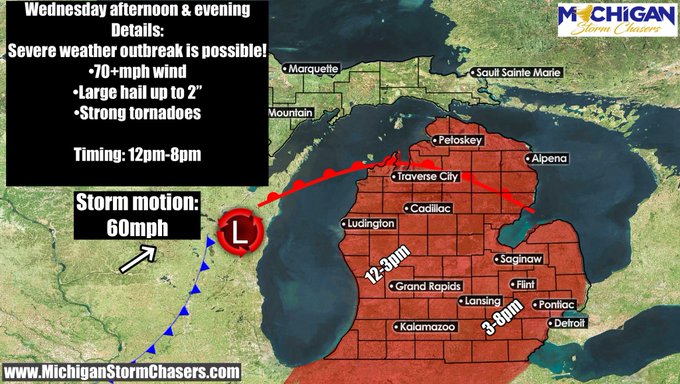
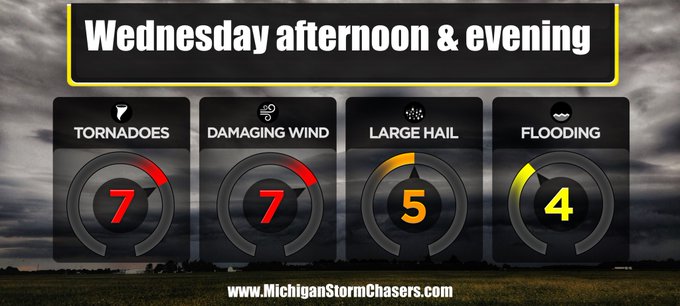
***A severe weather outbreak is possible for tomorrow afternoon and evening***
Overview: A strong low pressure system will swing through on Wednesday, lifting a warm front north across all of lower Michigan with gulf moisture being transported up. The combination of these 2 will…
2
10
40
Thank you to Holly for sending us this picture of a shelf cloud near US-127 and 20.
📸Holly Lee Horn
0
13
39
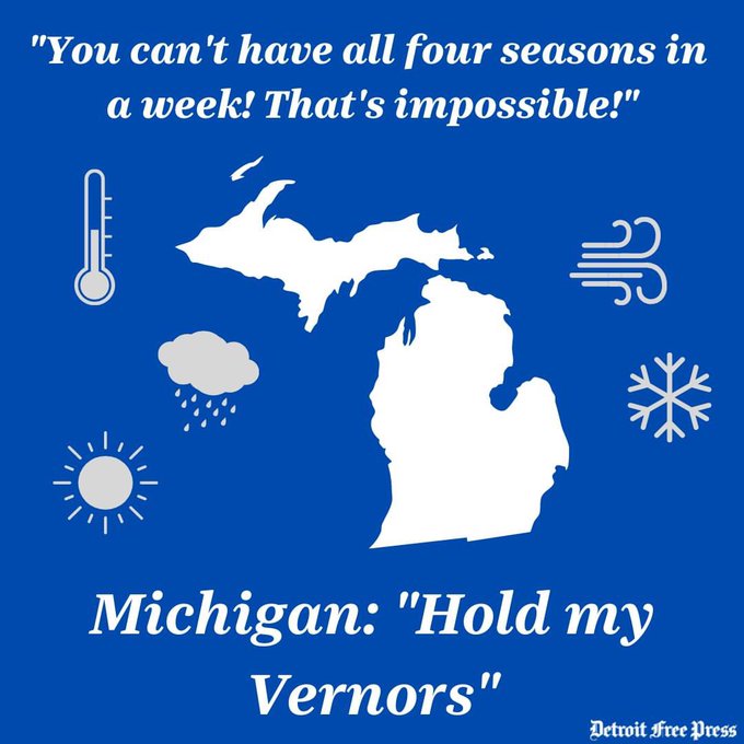
Sunday- Strong storms possible
Monday- Snow Showers possible
@freep
nailed it with this meme.
3
13
36
Forecast for today still on track. We removed the areas of greater coverage confidence due to an expectation that today will feature a more scattered nature of storms.
Storms are expected to develop across the lower peninsula today. With them, the potential for severe hail and…
2
9
39
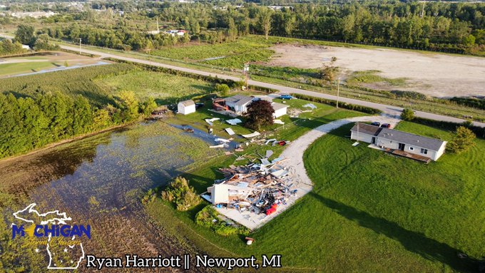
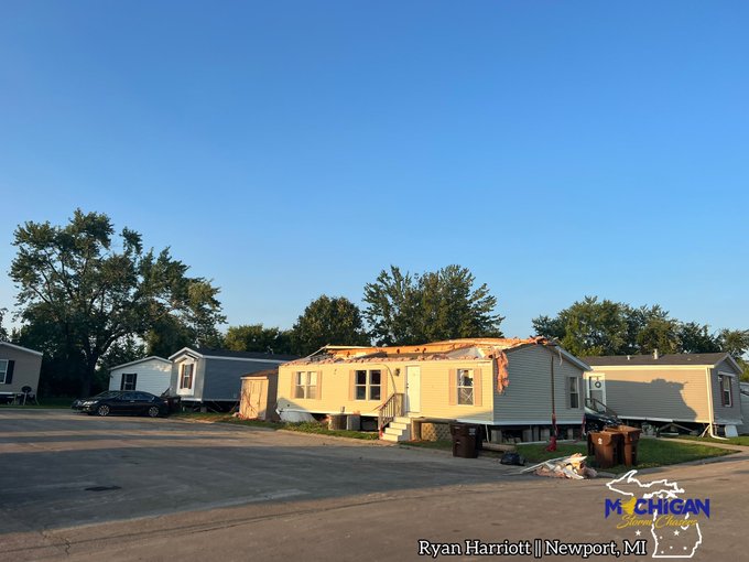
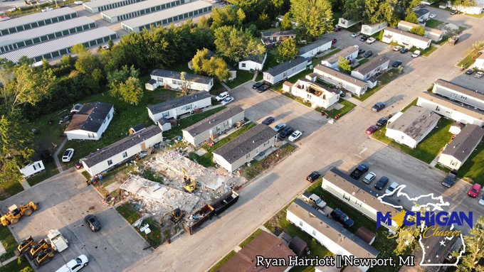
Our staff headed to Newport (Monroe County) to survey the EF-1 tornado’s damage path. Some highlights along the way was a garage completely destroyed on Newport road, several trailers sustaining roof and/or skirting damage, 3 completely destroyed, and multiple large trees…
0
5
38
Michigan Tornadoes Part 1:
We are beginning a new series here, looking at past tornadoes and events here on the page. This has been a popular requested topic and we’d love to share what we can. If you have any tornadoes you want to see an analysis on, please comment on it below!…
5
8
38
Tornado path continued northeast from 86/Burr oak to Ambs road with trees uprooted and corn layed flat, as well as pine tree tops snapped.
@NWSIWX
2
14
38
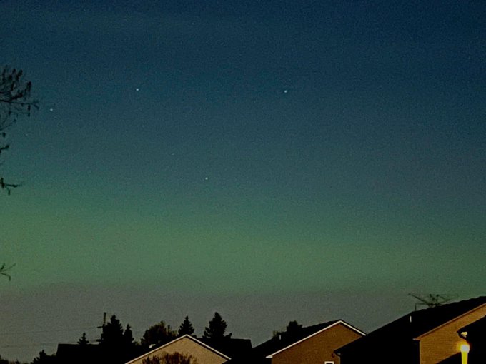
Aurora is OUT! These were taken in Commerce Township by Gene Sweeney moments ago.
#miwx
@AuroraNotify
0
10
37
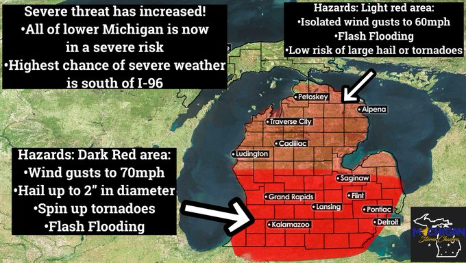
FINAL UPDATE: The severe weather threat has INCREASED this morning.
Due to higher than forecasted shear profiles and instability, we are increasing our severe probabilities today. The entire lower peninsula is now at risk for severe weather, with the highest threat (including…
0
14
38
First initial thoughts on severe weather potential for Tuesday night!
Bear with us! There’s a lot going on here on this map with an even more complicated explanation with many different scenarios being on the table! Let’s break this down as SIMPLE as possible.
First off we…
1
14
38
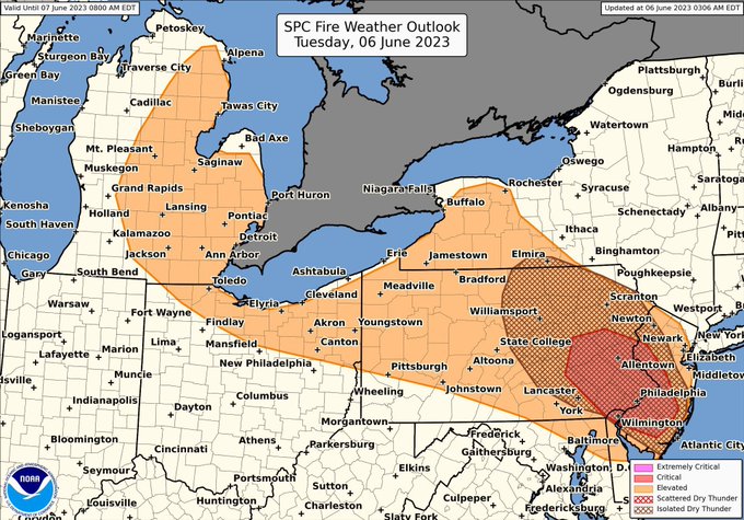
Please DO NOT burn today. Elevated fire risk exists across a portion of the state today and red flag warnings (burn bans) exist in northern Lower Michigan. Avoid burning, throwing cigarettes into dry grass, having campfires etc…
0
8
35
WOW! Check out the color from early this morning! The Northern Lights made a surprise appearance as the energy we expected tonight arrived early!
Active conditions may persist into tonight!
📸 Lisa Parrish 📍 Onaway
2
9
38
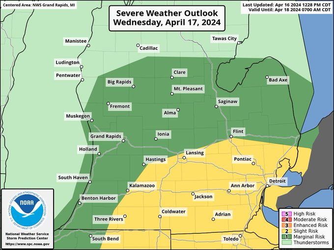
Severe weather discussion for tomorrow, Wednesday April 17th.
WHAT:
🟨A slight risk (risk level 2 out of 5) is in place for southeast Michigan. This is highlighted in YELLOW.
🟩Around the yellow risk, a level 1 of 5 risk known as a marginal risk is in place. This is…
1
11
37
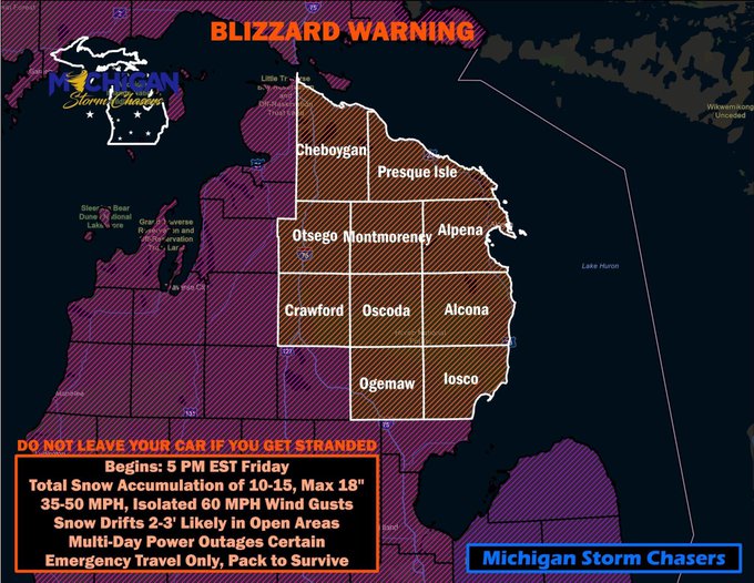
There it is, our first blizzard warnings of 2024 for Michigan. Given such a warning has been issued, we must reiterate the importance of what it means for cities such as Cheyboygan, Mio, Alpena, Alcona, East Tawas, West Branch, Luzerne, Grayling, Gaylord, Wolverine, and yes…
2
10
35
SEVERE WEATHER POSSIBLE TOMORROW:
We are going to break tomorrow’s severe threat down for you here as simple as possible.
SETUP: We have a low pressure system which will swing a cold front across the state. During the day we will have building temperatures and gulf moisture…
3
11
37
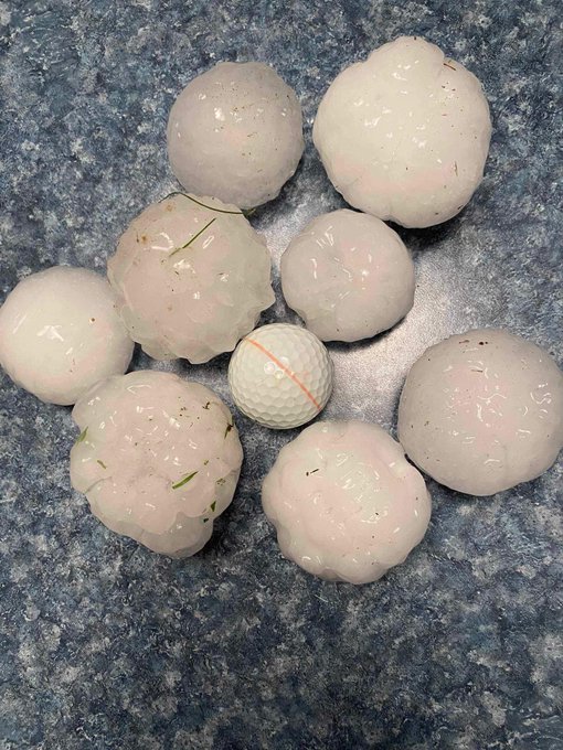
Surreal. Footage coming to us out of Davison, MI this afternoon of the 2.5” hail shattering vehicle windows, and leaving its mark on almost everything in sight!
A special thanks to Grazley Dell for sharing!
2
8
35
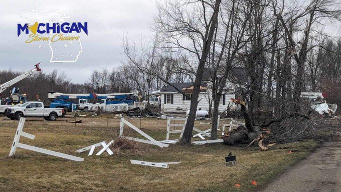
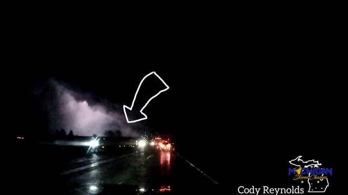
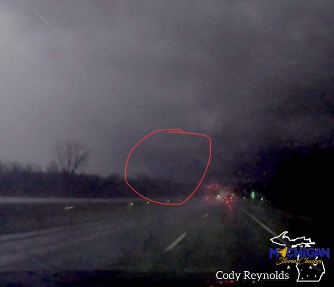
*GRAND BLANC TORNADO RATED PRELIMINARY EF-2*
Public Information Statement
National Weather Service Detroit/Pontiac MI
223 PM EST Wed Feb 28 2024
...NWS Damage Survey for 02/28/24 Tornado Event...
.Overview...A tornado was confirmed in Grand Blanc.
.Grand Blanc Tornado...…
0
12
34
A risk for severe weather exists tomorrow afternoon and evening in pretty much all of Michigan.
THE SETUP:
A shortwave/low pressure system will move towards Michigan in the afternoon hours Friday, which will be the focus for storm development.
HAZARDS/ INGREDIENTS/TIMING
By…
0
13
36
WHITEOUT! The combination of lake effect snow and blowing snow is creating havoc travel conditions, especially in rural areas where there’s nothing stopping these winds.
🎥 MSC: Ryan Harriott - Monroe County
0
5
36
Another cold air funnel is being reported right now near St. Charles, MI! 3:35pm
Credit:
@TobiasChasingWX
@NWSDetroit
1
10
37