
NWS Northern Indiana
@NWSIWX
Followers
27,114
Following
225
Media
17,428
Statuses
37,151
Official Twitter account for the National Weather Service Northern Indiana. Details: http://t.co/KKTK7cZlhK
Syracuse, Indiana
Joined June 2012
Don't wanna be here?
Send us removal request.
Explore trending content on Musk Viewer
Arsenal
• 512486 Tweets
Flamengo
• 166875 Tweets
DAVI NO DOMINGAO
• 124229 Tweets
Corinthians
• 103552 Tweets
Botafogo
• 93032 Tweets
Knicks
• 79909 Tweets
Wesley
• 78136 Tweets
Brunson
• 69711 Tweets
Embiid
• 66532 Tweets
Sixers
• 40199 Tweets
Romero
• 38965 Tweets
Philly
• 38825 Tweets
Sporting
• 33159 Tweets
Candace Parker
• 31664 Tweets
Clippers
• 27995 Tweets
Velez
• 27667 Tweets
Sevilla
• 27470 Tweets
الزمالك
• 25803 Tweets
Felipe Melo
• 22088 Tweets
Diniz
• 19620 Tweets
Betis
• 19061 Tweets
Kawhi
• 16422 Tweets
Kyrie
• 15387 Tweets
Cano
• 14882 Tweets
Harden
• 14242 Tweets
#OMRCL
• 12381 Tweets
Paul George
• 11954 Tweets
Renato Augusto
• 10127 Tweets
Last Seen Profiles


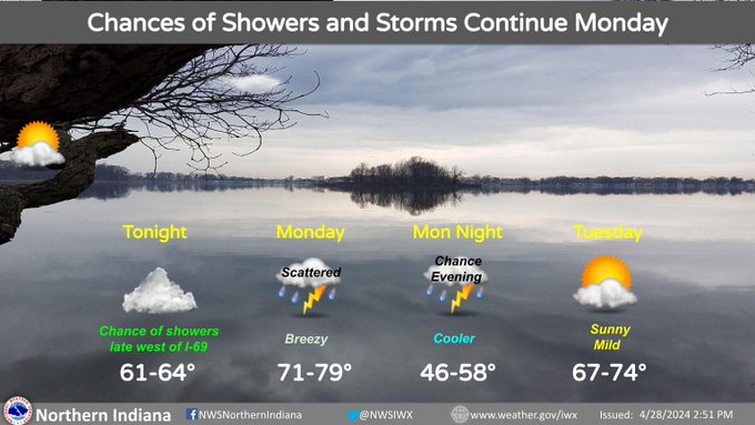
More rain showers are expected to move into NW IN and southwest Lower MI later tonight, with scattered showers and thunderstorms redeveloping again on Monday. The chance of showers will linger into Monday evening, but dry weather and sunny skies return for Tuesday.
0
1
5
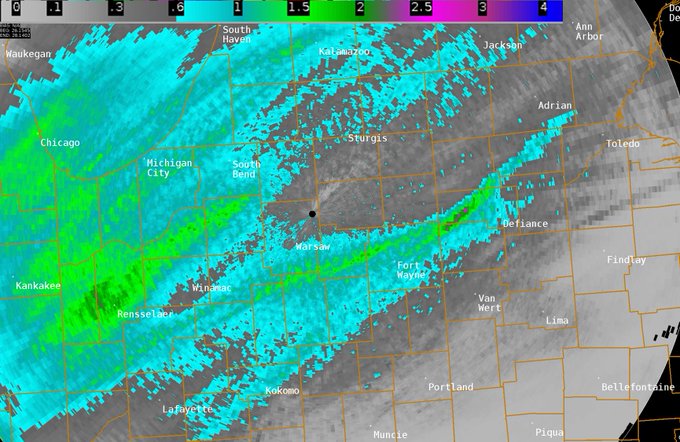
Below is a map of radar estimated rainfall last 24 hours. Brighter green colors indicate areas that have likely received 1"+ of rain. Some observers have also reported actual rainfall amounts in excess of an inch in these heavier swaths.
0
2
7
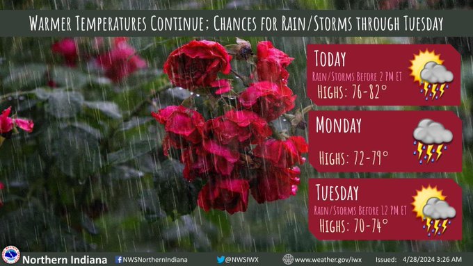
Rain/storms persist mainly along and north of US-6 this morning before diminishing by 2 PM ET. Additional rain/storm chances are likely Monday through Tuesday morning upon the arrival of a cold front. Warm temperatures continue with highs in the 70s to low 80s.
0
7
13
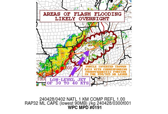
From the Weather Prediction Center, areas of flash flooding will be possible overnight in northwest Indiana. We will wait to see how the heavy rain potential sets up overnight, but right now our current thinking is that the best chances for flash flooding will be west of IN 13.

0
5
14
Severe weather has impacted much of the Central Plains in the past 48 hours. We are thinking of everyone at NWS Norman and NWS Tulsa as they have a long night ahead ❤️ Intense, rain-wrapped tornadoes are never something you want to see on radar, especially at night.
2
18
62
Here's a look at severe weather operations at one of the busiest offices for severe weather in the country right now! We're thinking of everyone working at NWS Norman and the Storm Prediction Center as they handle a very busy day of severe weather ❤️

720pm - Behind the scenes as we enter our 13th hour of severe weather operations. A long night ahead.
88
410
3K
1
13
70
It was a windy day! Here are the peak wind gusts for Saturday, April 27th:
-
@flyfwa
: 53 mph
-
@SBNairport
: 45 mph
- Benton Harbor, MI: 44 mph
- Goshen, IN: 44 mph
- Van Wert, OH: 43 mph
- Huntington, IN: 42 mph
- Defiance, OH: 41 mph
0
4
14
Chances for showers and thunderstorms will increase tonight for some . While locally gusty winds could accompany the strongest storms, locally heavy rainfall poses the greater concern. Rainfall rates of 1-2”/hr could lead to minor flooding in some areas.

1
10
24
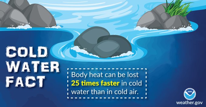
With warm weather this weekend, you may be heading to Lake Michigan to cool off. While water temperatures are slowly warming, they are still only in the upper 40s to near 50 degrees. Just because the air is warm doesn't mean the water will be! Stay out of the water!


0
7
18
Wind gusts will be between 30-35 mph today, with a few gusts up to 40 mph. Warm temperatures and scattered rain chances will persist through the weekend and into early next week. A cold front brings better chances for rain and storms Monday afternoon/evening.
0
6
12
It has been a very impactful severe weather day in the Central Plains. We're keeping our colleagues at NWS Hastings, NWS Omaha, and NWS Des Moines in our thoughts as their forecast areas have been devastated by tornadoes ❤️ Our hearts go out to anyone impacted ❤️
4
64
307
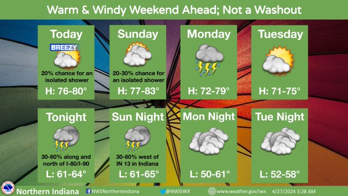
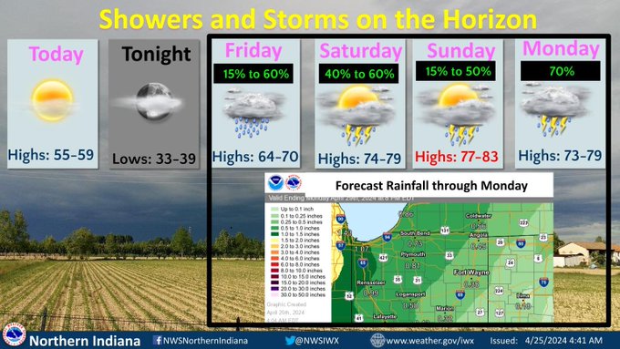
Scattered rain showers can be expected tonight into Sat AM with a few storms possible. Isolated storms may redevelop Saturday afternoon, with an isolated strong storm possible. Warm and windy this weekend with highs from mid 70s to lower 80s. More rain chances Sun night-Mon.

0
8
10

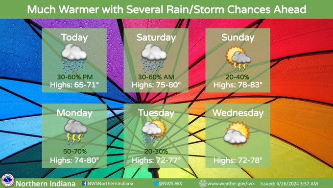
We close out April with an active and wet week ahead! Multiple days with rain/storm chances and highs in the mid 70s to low 80s are likely this weekend into early next week! ⛈️⛅️☔️
0
7
11
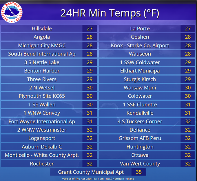
Here's a look back at the chilly low temperatures this morning! Many areas dropped below freezing, with a few locations even experiencing a hard freeze (temperatures at or below 28 degrees)! 🥶 Temperatures are only expected to fall into the mid to upper 30s tonight for lows.
0
2
4
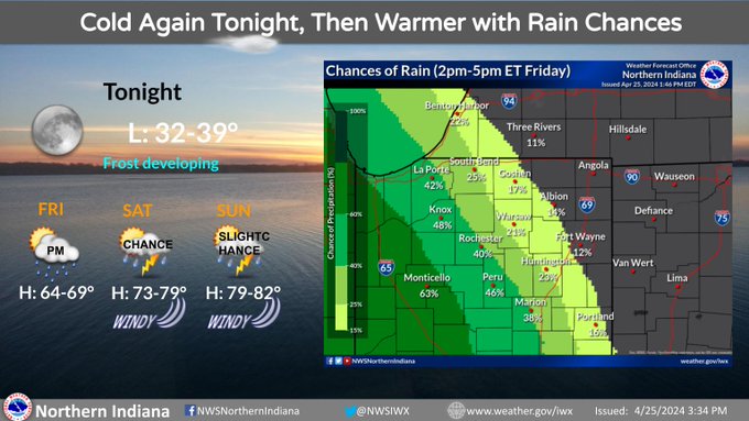
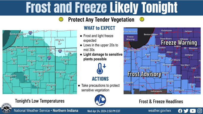
Frost is expected to develop again tonight across portions of the area. A Frost Advisory in effect through early Friday morning. Turning windy and warmer for the weekend with chances of showers and storms.

0
5
7
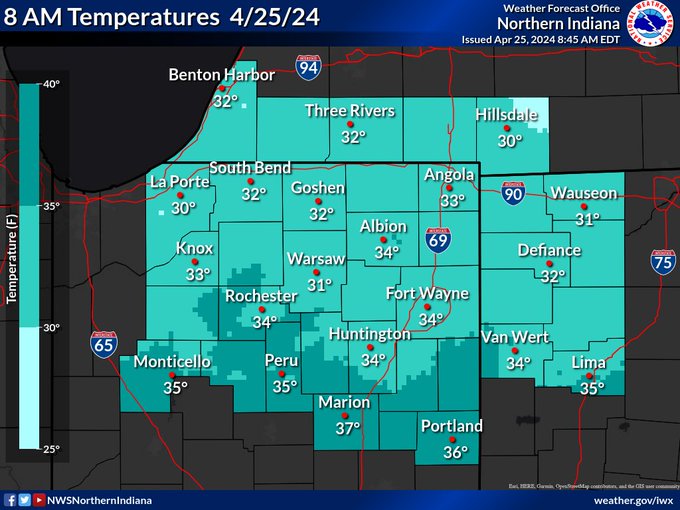
A few locations were still hovering around the freezing mark at 8 AM ET this morning. Temperatures will continue to rise into the low-mid 40s by 10am. Another night of some patchy frost potential is in store tonight, especially along and east of I-69.
0
4
8
Much warmer air will return accompanied by several rounds of showers and storm through Monday. The heaviest total rainfall is expected to be west of Highway 31. Highs will mainly be in the 70s to around 80.
1
11
19
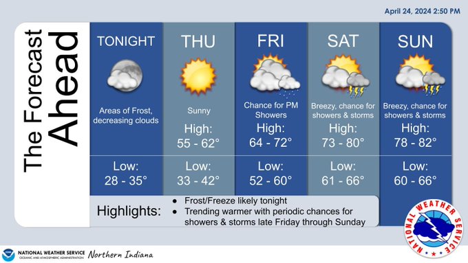
Frost/freeze conditions late tonight will give way to a significant warmer trend by this weekend. Breezy and increasingly moist southwest winds will also usher in some shower and storm chances Friday afternoon into the weekend.
0
6
3
Temperatures will fall into the upper 20s to mid 30s late tonight with frost formation expected.
0
4
7