
Dr. Amy H Butler
@DrAHButler
Followers
8,119
Following
2,648
Media
706
Statuses
4,455
Atmospheric Scientist at NOAA Chemical Sciences Laboratory, atmos dynamics/chemistry-climate, polar vortex expert. Views expressed are mine.
Boulder, CO
Joined December 2015
Don't wanna be here?
Send us removal request.
Explore trending content on Musk Viewer
Israel
• 2301428 Tweets
#Eurovision2024
• 1400686 Tweets
España
• 313989 Tweets
Mother's Day
• 189864 Tweets
New Jersey
• 181061 Tweets
Switzerland
• 155542 Tweets
Flamengo
• 124358 Tweets
#母の日
• 116413 Tweets
Nemo
• 113762 Tweets
Corinthians
• 109827 Tweets
Luka
• 99638 Tweets
Suiza
• 63354 Tweets
Croatia
• 49637 Tweets
プリキュア
• 45527 Tweets
#仮面ライダーガッチャード
• 44020 Tweets
Kyrie
• 37370 Tweets
Mavs
• 33606 Tweets
#UFCStLouis
• 31871 Tweets
Barco
• 27574 Tweets
DAIGO
• 22102 Tweets
#ブンブンジャー
• 22043 Tweets
Igor
• 21337 Tweets
ストフェス
• 18313 Tweets
Herrera
• 17121 Tweets
カグヤ様
• 15805 Tweets


23
351
1K
I'm very honored to receive NOAA's 2021 Dan Albritton Outstanding Science Communicator Award "for outstanding communication of NOAA research regarding the impact of variations in the stratospheric polar vortex on weather at the Earth's surface."
23
3
203
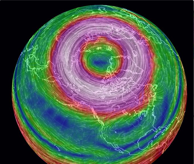
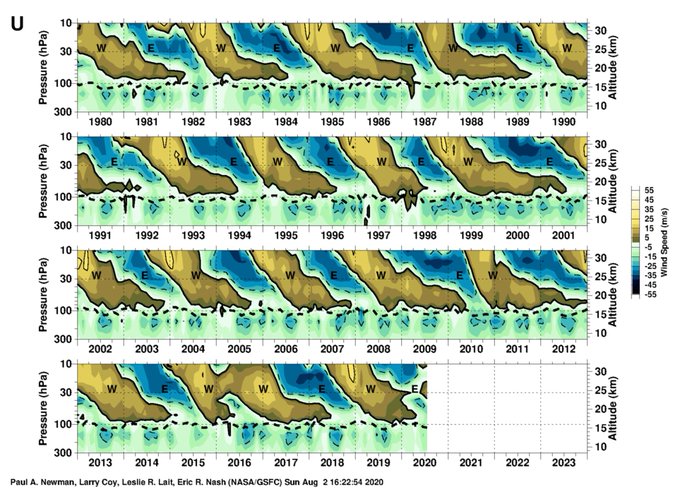
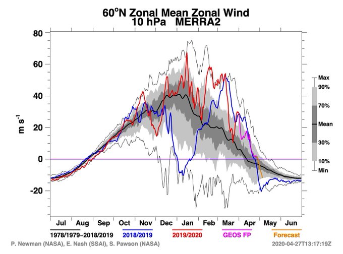
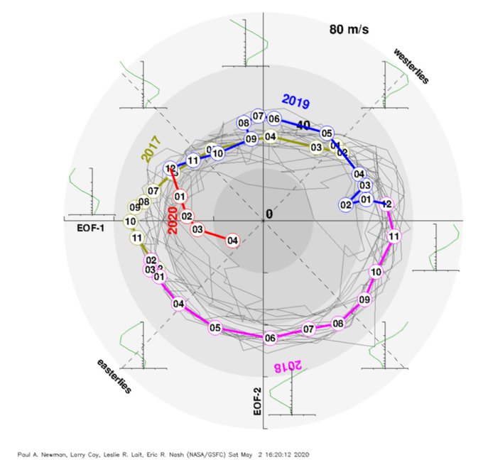
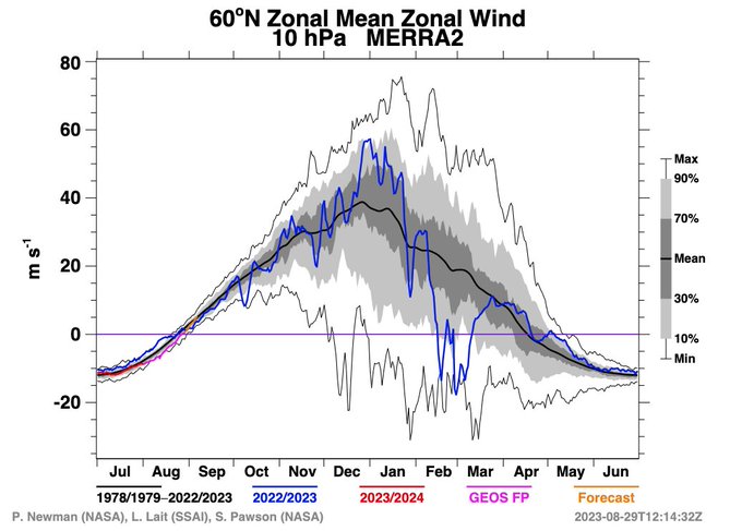
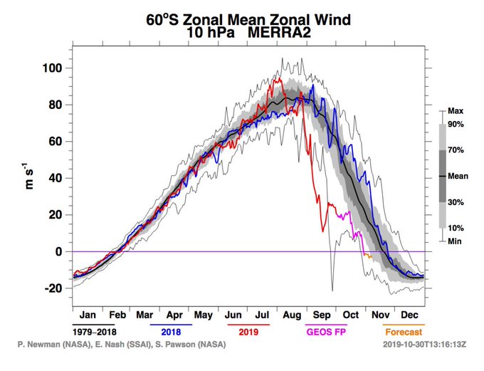
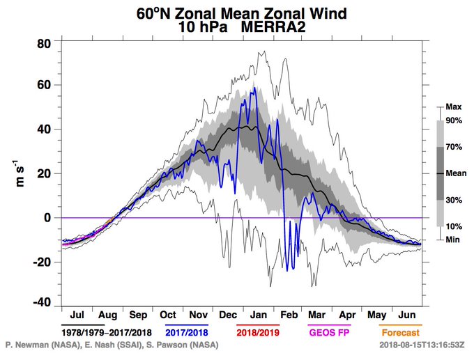
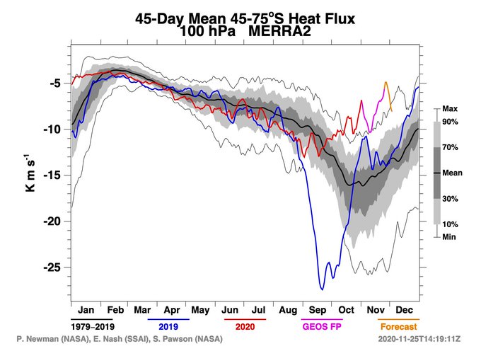
A rare sudden warming of the Antarctic polar vortex, a disruption of the Quasi-biennial Oscillation, and a record strong Arctic polar vortex; 2019-2020 was a banner year for oddities in the
#stratosphere
.
2
59
195
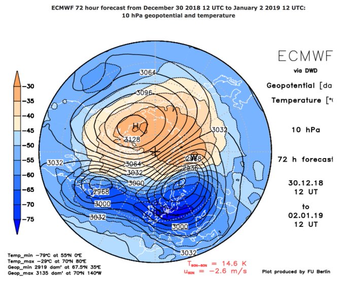
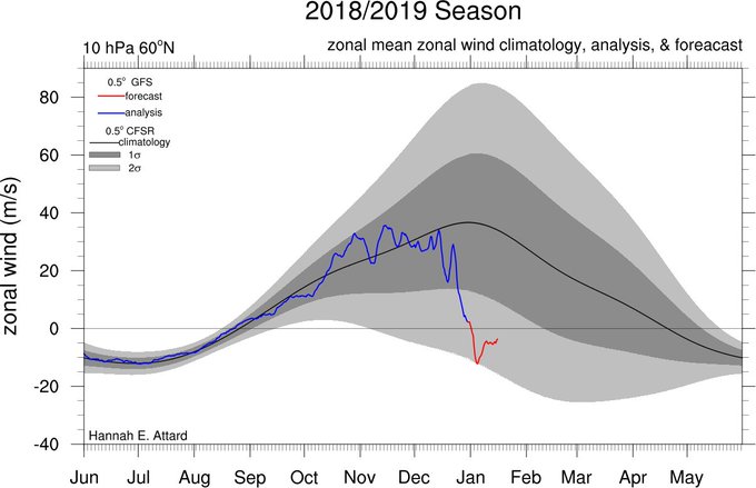
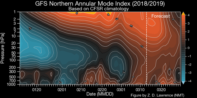
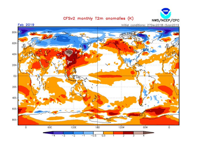
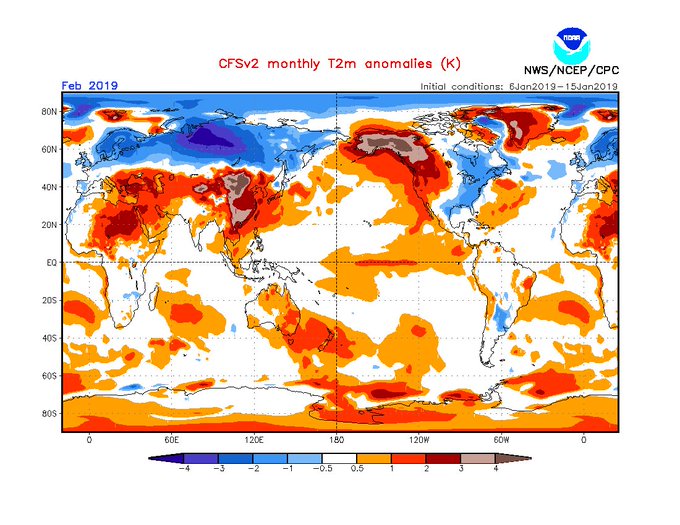
Couldn't ask for a better start to 2019 than a major
#SSW
split! Happy New Year, everyone!
16
39
172
Guess what? (1) The polar vortex visits us every year. It’s a feature of winter circulation. (2) The breakdown of the polar vortex, which brings cold weather, does not seem to be increasing in frequency nor is there consensus it will by 2100.

8
51
168
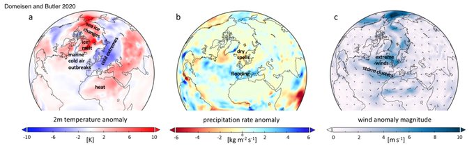
1/ Chances looking high for stratospheric
#suddenwarming
in Jan. What do SSWs mean for surface weather?
@Domeisen_D
and I describe how these events can lead to surface extremes in (open access!). This graphic shows examples of impacts in weeks following.
9
49
171
I'm honored to have received the AGU Atmospheric Sciences Ascent award. I feel so fortunate to have had such amazing mentors to get me where I am in my career today. Truly a dream come true!
@theAGU
@NOAA_ESRL
21
1
161
We usually say the stratosphere doesn't couple to the troposphere in summertime, but this year that final stratospheric warming that happened 2 months ago has had some serious long-lasting influence on the troposphere well into meteorological summer.
15
42
154
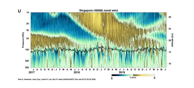
If you think of the stratospheric Quasi-biennial Oscillation as the heartbeat of the atmosphere, in the last 4 years it's been having a serious arrhythmia.
#QBO
8
35
146
Check it out! I'm so excited to be a part of this new effort.
9
16
144
The polar vortex isn't "on the horizon". The polar vortex is a regular feature of the wintertime stratosphere. It's the complete dissolution of the polar vortex that brings cold weather, not its appearance- in fact, a strong polar vortex would mean warmer weather for much of us!
10
29
126
The stratospheric final warming for 2020 has now occurred, on April 29. It was a fascinating winter in the stratosphere! See you at the end of August,
#polarvortex
.
7
28
127
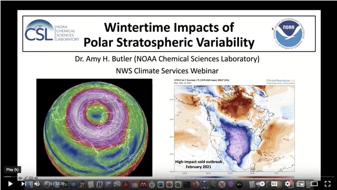
Here's a link to the presentation I gave for the NWS Climate Services Seminar Series, on "Wintertime Impacts of Stratospheric Variability", for those interested!
3
18
127
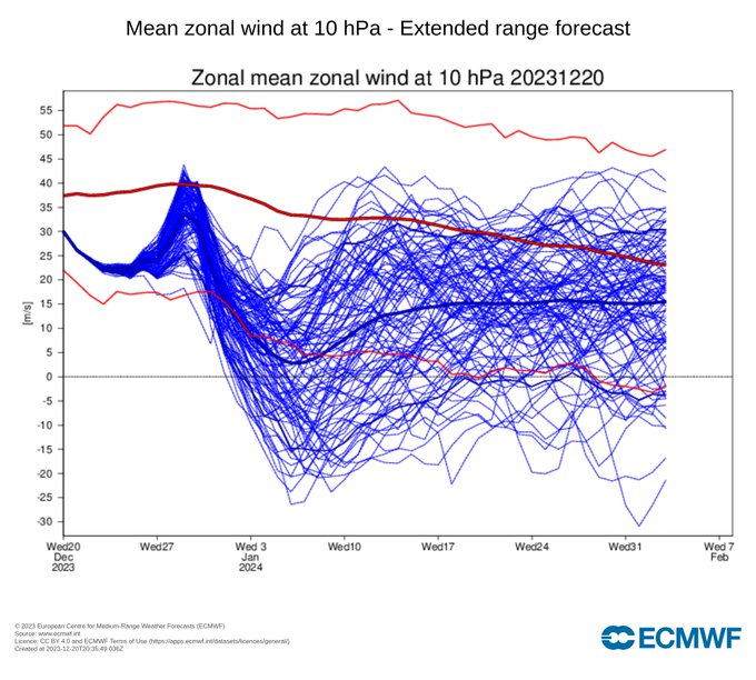
There is a lot of
#twitter
debate about the near to extended range
#polarvortex
forecasts, so let’s review what is going on (a 🧵):
6
19
125
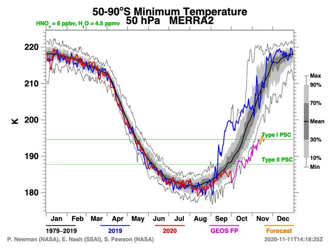
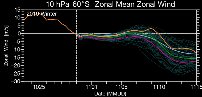
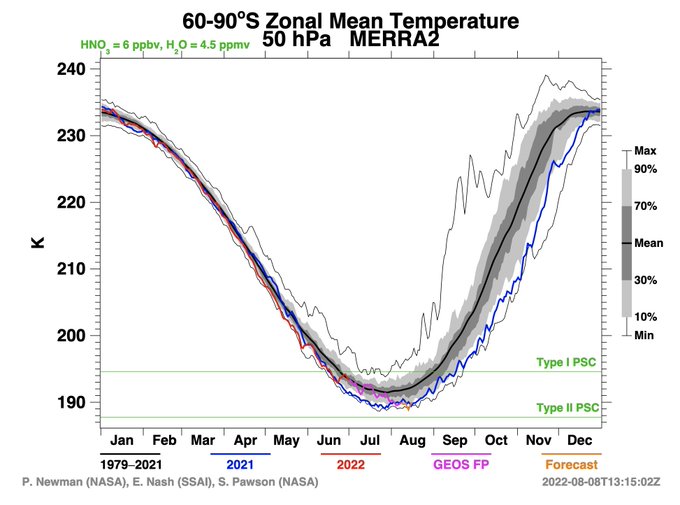
Never before seen minimum temperatures in the Southern Hemisphere
#polarvortex
... with temperatures cold enough for PSC Type II formation a full month longer than average.
8
33
119
Please don't confuse the tropospheric jet stream with the stratospheric polar vortex. I also have seen no convincing evidence that, even if the jet stream does get wavier and drives cold outbreaks (which is a big "if"), it will at all compete with the general warming trend.

Confused about longer and more extreme periods of heat and cold in the northern hemisphere? They have a lot to do with human-induced
#climatechange
and stalled weather patterns, resulting from an altered
#jetstream
.
Latest research supported by
@NASA
➡️
59
566
711
5
38
115
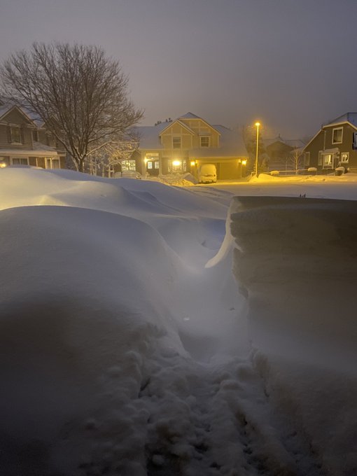
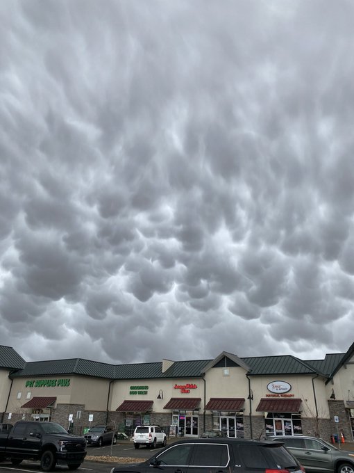
30” snow drifts creating some otherworldly mounds outside our door as the epic day of snow comes to a close.
#cowx
3
8
119
Can't think of a better way to start a new year than with a
#SSW
. 🎉 GEOS forecast model on board with some massive stratospheric heat fluxes in the next 10 days.
4
24
120
A month after the
#polarvortex
split, we are finally seeing some zonal-mean type stratosphere-troposphere coupling in the form of a very negative AO (about -3 stdevs). This is not projecting into the N Atlantic however; NAO is contrarily staying positive.
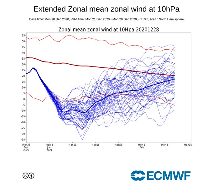
12
29
113
Latest forecasts suggest a major
#SSW
is off the table for now. Just not getting the amplitude of planetary wave breaking that you typically see before a complete reversal of the
#polarvortex
winds. Still, will be interesting to see how things evolve in Feb!
5
14
117
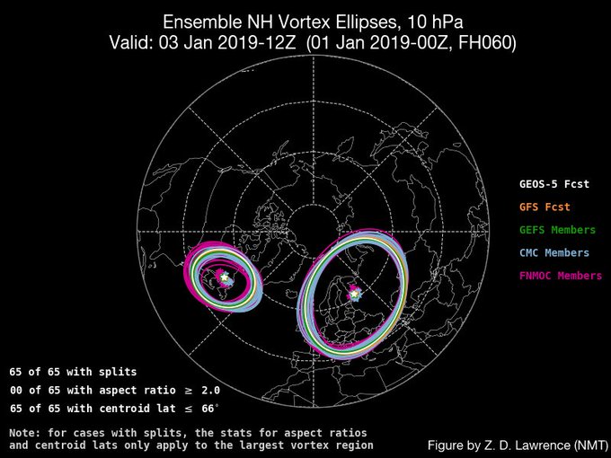
😁 65 of 65 ensemble members with splits by Jan 3 (wind reversal should occur before then).
5
20
118
(1/) I think this is pretty cool. The minor
#SSW
last week looks to reinforce/support the upcoming Greenland block over the next week. (this plot shows the NAM index but the red colors essentially captures the high pressure over Greenland consistent with -ve NAM)
7
30
118
Another disruption of the tropical stratospheric winds; what does it mean?? This time in the opposite phase of the
#QBO
as the last disruption in 2016.
8
23
113
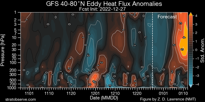
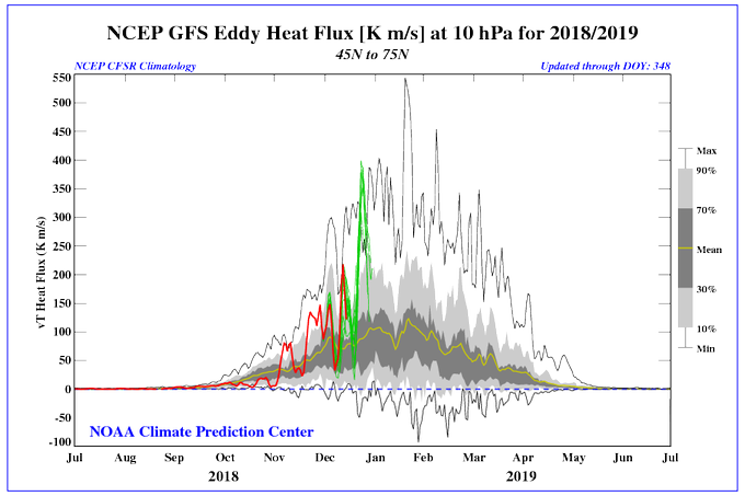
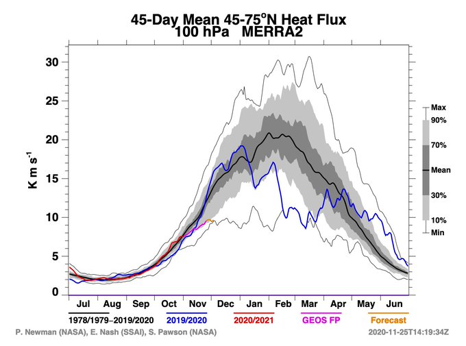
(1/n) One measure I pay close attention to in winter is the "eddy heat flux". What does that mean? Eddy heat flux is basically referring to the heat transported from the tropics to the poles by weather fronts (otherwise, the tropics would be much hotter and the poles colder!).
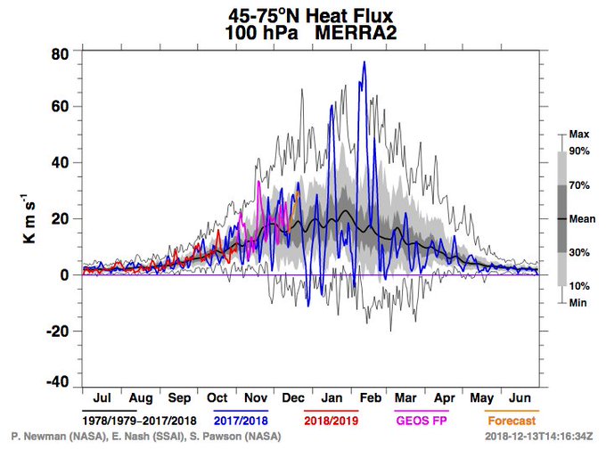
10
23
115
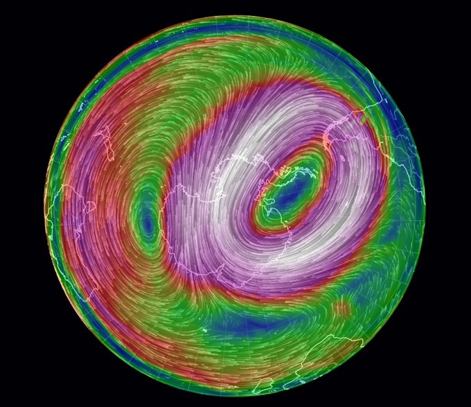
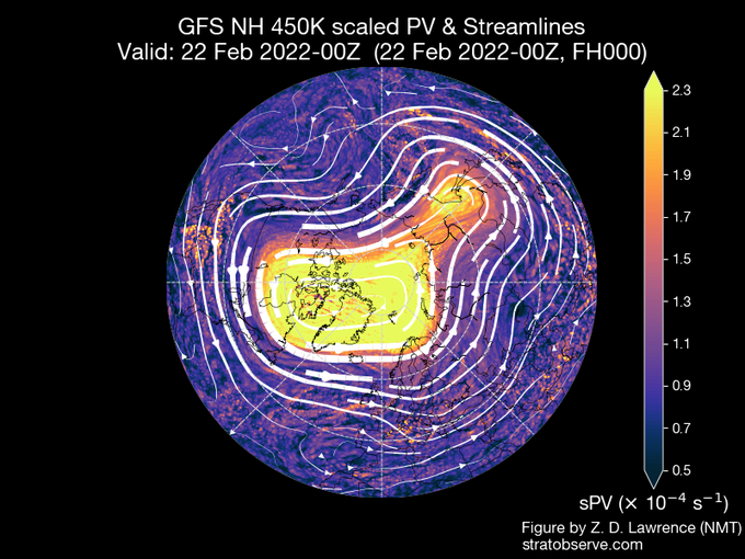
(1/) The
#SSW
looks to unfold as follows. The stratospheric Aleutian high grows in strength and pushes the
#polarvortex
over Eurasia. Watch its clockwise flow pull the vortex filaments (shown in red) around it, like cotton candy.
2
34
114
(1/) I know it’s disappointing for many when a major
#SSW
suddenly looks like it’s not going to happen. While it’s now looking much less likely to be a major warming, it will at least be a minor one, with about a 25 degC increase in 10hPa temps in 5 days.
4
20
114
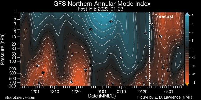
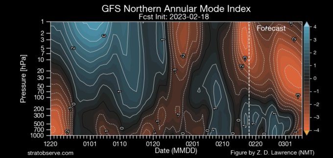
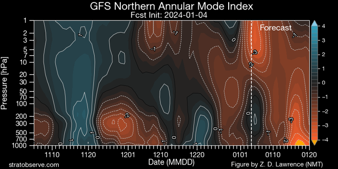
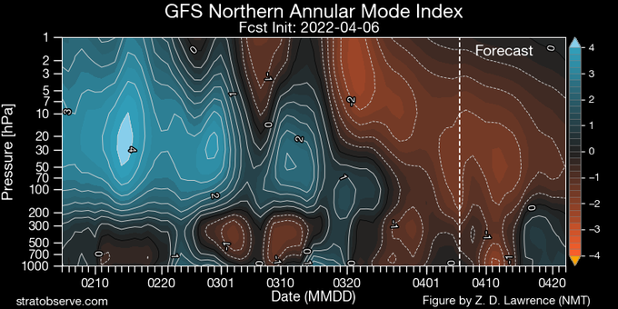
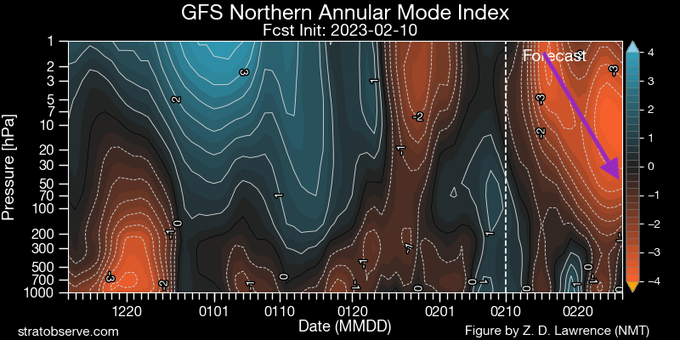
(1/) What might we look for over the next few weeks to see if the
#SSW
is having a impact on surface weather? The go-to index is the "northern annular mode" index. The NAM is a measure of mass fluctuation between the pole and the mid-latitudes.
4
17
112
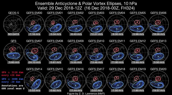
A clear distinction btwn 2 possible futures of the
#polarvortex
over next 10 days- some ensemble members seeing a
#split
vortex w/the larger lobe over Eurasia, while majority still see a displacement. But, forecast models struggle to predict splits more than a week ahead of time.
4
30
106
I decided to switch to
#Python
this week. So far my programming path has been Mathematica (college) --> Matlab (grad school) with some GrAds thrown in --> IDL (job). Wish me luck!
17
2
109
Happy to contribute to this piece at
@NOAAClimate
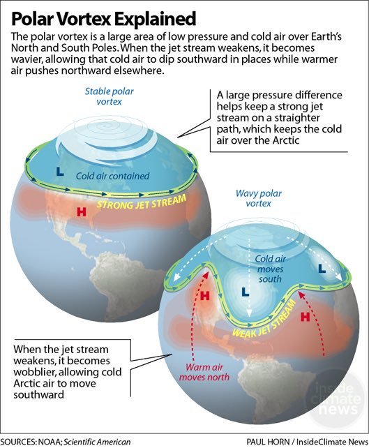
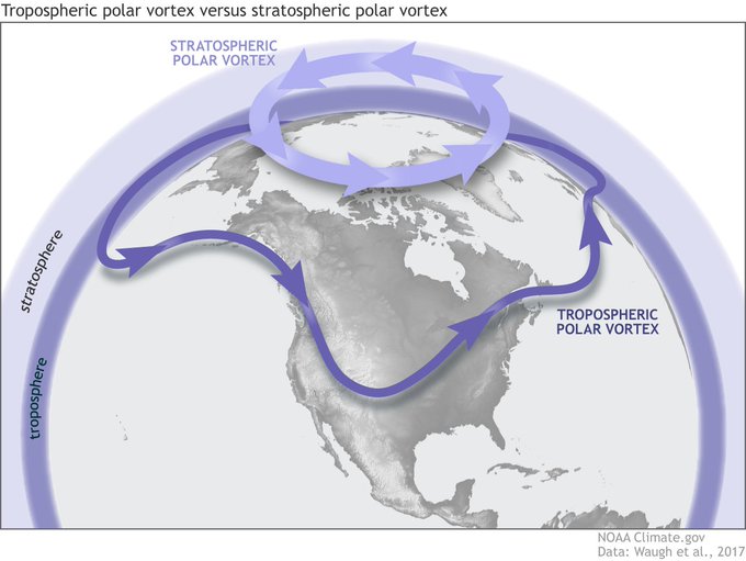
, and check out the new updated NOAA schematic on the
#polarvortex
!

Still have questions about the
#PolarVortex
? Polar vortex expert Amy Butler and Arctic expert James Overland offer perspectives on the February cold snap in the southern U.S., the polar vortex, and how the Arctic might influence mid-latitude weather.

3
141
270
3
25
108
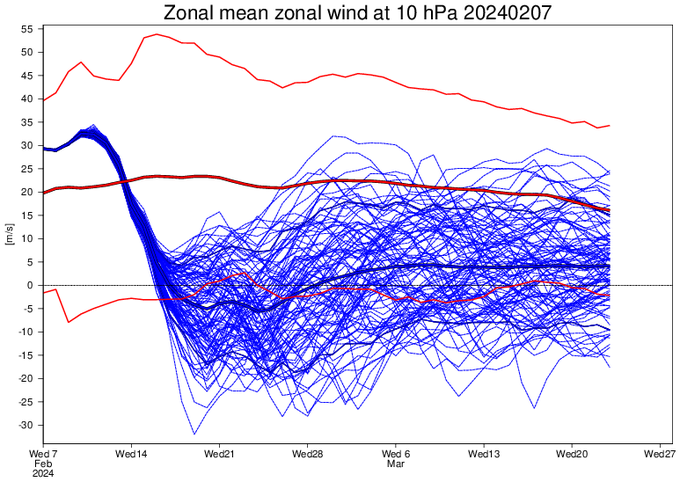
#GFS
, while maybe overdoing it a bit, is beautifully ripping the
#polarvortex
to shreds around Feb 16th.
#SSW
2
22
108
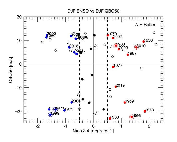
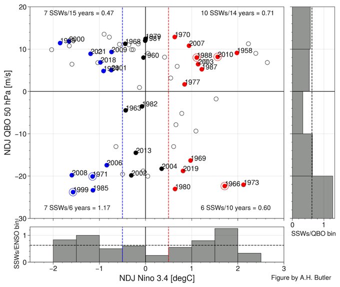
(1/n) What factors might influence the
#polarvortex
this winter? QBO and ENSO both can have an effect; however, for westerly QBO and La Nina conditions expected this winter (upper left quadrant), an equal number of years (7) have had SSWs (solid dots) as not (empty dots)....
4
24
104
1-How will the stratospheric
#polarvortex
respond to
#climate
change? Bottom line: we have no idea. A 🧵on a new paper out by Alexey Karpechko,
@HillaA1
, me,
@Domeisen_D
,
@Marlene_Climate
,
@zd1awrence
, E. Manzini,
@michaelsigmond
,
@IslaSimpson4
, and Z. Wu:

4
33
105
The Northern Hemisphere
#polarvortex
currently has near record low temperatures, but the
#GFS
at least is showing signs of a large wave-1 event in the coming weeks, accompanied by up to a 30 m/s slowdown and 10-20K warmup. No
#SSW
predicted yet but something to keep an eye on.
8
22
106
A major
#SSW
looks likely to occur tomorrow- check out the new blog post about it!
The latest forecast says a major disruption of the polar vortex is on its way, but the stratosphere has been acting up for a while. Our bloggers explain what it might mean for U.S. weather:
1
26
96
5
23
102
I have to agree. The theory that the vortex could be affected by climate change, while possible if the models are really missing a key process, is generally a minority view at this point, but it’s being conveyed as fact.
8
37
97

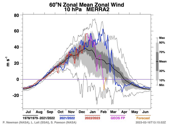
Near record daily wind speeds in the Arctic polar vortex for the next few days; GEFS has 100% of its members showing record strong conditions. This could prime conditions for wave propagation in the next few weeks, so worth keeping an eye on!
5
24
99
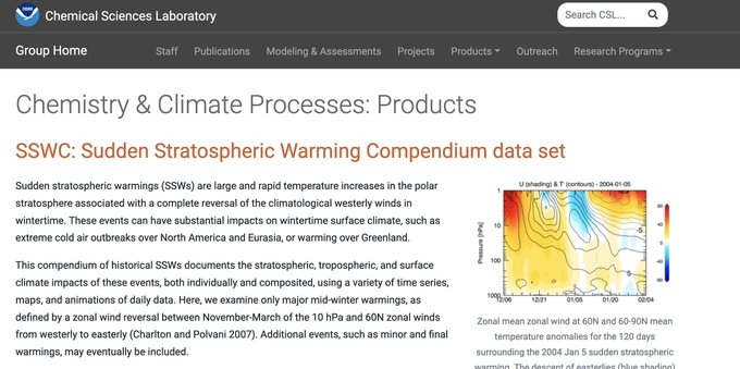
I've updated the list of sudden stratospheric warming
#SSW
dates for different reanalysis products through 2023. I added ERA5 too! I hope this is a useful resource for the community.
6
21
98
ECMWF has been insistent for a couple weeks now that the
#polarvortex
will weaken in December into January, but the GEFS is stubbornly holding onto a strong vortex relative to its own climatology (note, GEFS does not run out as far as ECWMF).
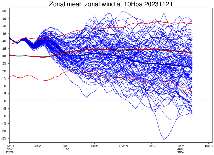
5
19
98
It is December, and we are still seeing an
#ozone
hole area as large as typically seen in mid-October.
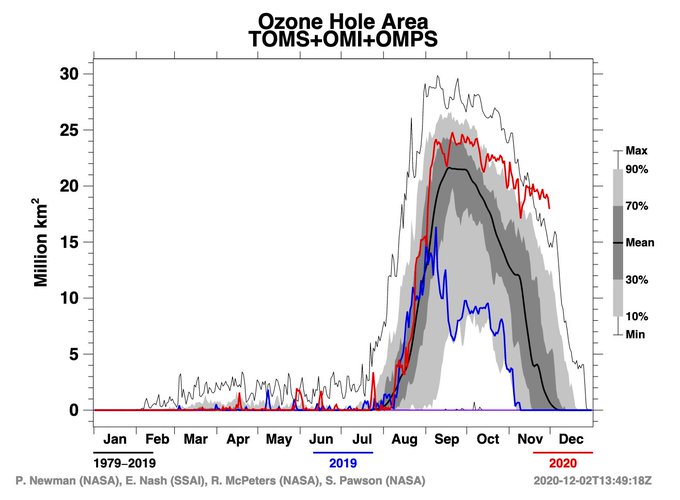
4
36
94
(1/2) It's
#SSW
day! While the temperatures in the mid-stratosphere have already increased by ~30K, the date of the event is defined by when the winds that normally flow from the west at 60N and 10 hPa reverse direction and flow from the east instead.
5
27
97
Check out the latest Polar Vortex Blog post on reasons why the minor
#SSW
wasn't able to quite make it to major status... and chances of that changing in the next couple of weeks!
Recent atmospheric patterns don't match those that typically precede a sudden stratospheric warming event. But forecasts do suggest the polar vortex might get stretched out of shape in coming weeks. Read the latest Polar Vortex Blog:
6
56
161
4
20
96
This store is just down the street from NOAA and NCAR and I go there fairly frequently. No words... just sadness that you can basically get shot doing anything nowadays and nothing ever changes. Just thinking of the families and hoping I didn’t know anyone. 😢
#boulder

.
@TonyKovaleski
reports multiple sources tell him at least six people are dead in the shooting at the King Soopers in Boulder. We will have a live news conference starting shortly. Latest developments here:
Live streaming coverage:
4
69
57
3
2
95
This is just a really awesome high resolution animation of the
@NASAEarth
's GMAO forecasts of the
#SSW
. The vortex air gets pulled like taffy into the stratospheric high pressure system. Then a huge blob of low potential vorticity (tropical?) gets pulled into the mix!
6
29
94
Popular Sci: "The polar vortex is about to split in two. But what does that actually mean?" by Philip Kiefer, with myself,
@alopezlang
, and
@MJVentrice
.

1
29
94
(1/) NOAA GEFS has been trending towards higher likelihood of
#SSW
as well.

Odds on for a major SSW?
(And yes, I'm stealing that phrasing from the Met Office's infamous "barbecue summer" forecast)
21
10
130
2
17
92
Happy
#SuddenStratosphericWarming
Day! The exact date will depend on when the daily-mean zonal wind falls below 0 m/s; I'm guessing it will be today, Feb 16th, but will have to verify.
4
13
89
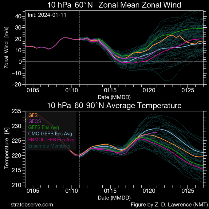
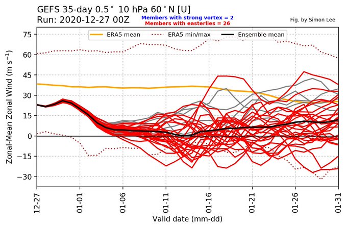
All GEFS members now committing to a reversal of 60N 10mb winds
#SSW
between Dec 25-30 which is somewhat astonishing for a 9-14 day forecast. However not all other models on board yet so still reason to be cautious.
17
26
84
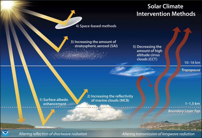
Read our new study which highlights how the stratospheric
#polarvortex
responds to sulfate aerosol injections, potentially leading to unintended consequences like winter warming.

A new NOAA study highlights the vast challenges and potentially damaging consequences of solar geoengineering actions large enough to ward off extreme warming by the end of the 21st century.
3
62
140
4
32
87
I find it interesting that I have yet to see anything in the media about the strong
#polarvortex
event unfolding, despite it potentially having as significant of strat-trop coupling/sfc influence as the
#SSW
. Time of year issue? Not as cool looking?
13
20
80
It may be only a minor
#SSW
, but with the troposphere conducive to coupling (thanks El Nino?) we could see a pretty nice amplified -ve NAO the next couple of weeks with any luck.
7
11
86
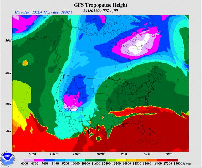
If you're in the SW USA, the stratosphere is only 6km (3.7 miles) above your head today. But in the SE, it's 18km (11.2 miles). These are a nice new suite of products from NCEP CPC:
9
28
83
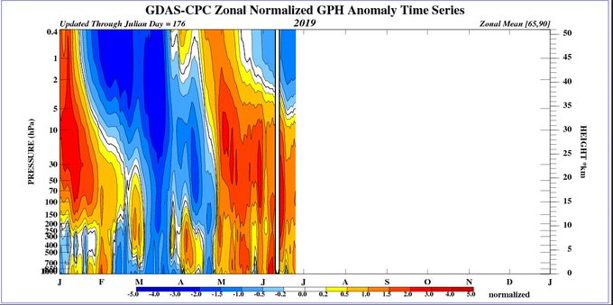
(1/2) The Northern Hemisphere polar vortex started its annual formation on Aug 27th.
4
19
82
(1/2) This year's NH stratospheric final warming, which occurred on Mar 20, has led to top 10% weakest winds in the stratosphere for this time of year, and has exhibited significant downward influence.
4
12
84
(1/6) Things are getting stirred up in the
#stratosphere
. Last week we saw a large chunk of the lower stratosphere
#polarvortex
start to shear off, corresponding to a strong pulse in heat flux.
2
24
81
Can’t tell you how many interview requests I get to discuss “how climate change is driving more cold air outbreaks”... I agree with the importance of the
#polarvortex
but in an increasingly warming world I think cold air outbreaks will become much rarer, not more common.
6
11
79
(1/3) There are some
#SSWs
that are clearly driven from the the bottom up (from atmospheric waves associated with mountains, land-sea contrast, and persistent weather patterns), but this one to me is of the "top-down" variety.
7
15
81
The Arctic
#polarvortex
will start to reform about a week from today... GEOS predicting return to westerlies at 10 hPa on Aug 26 (look at pink/orange line on this plot).
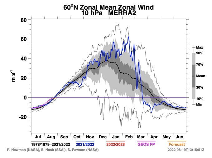
5
10
81
#PolarVortex
looks to elongate over the next week, then displace towards Eurasia. That general picture seems agreed upon by the models, but how much displacement and wobbling occurs varies quite a bit, and only a handful of the ensemble members show a major
#SSW
right now.
5
28
79
ECWMF still pretty confident about a major
#SSW
, while other systems like GEFS not so clear. Either way, forecasts seem to agree that the vortex is about to be seriously stretched out and disturbed in the coming days.
5
18
77
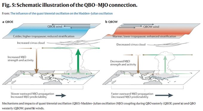
The QBO-MJO relationship has some interesting characteristics yet to be fully explained, which we detail in our new review paper. Check it out!

The QBO & MJO are connected during boreal winter. In their Review,
@zanekmartin
, Seok-Woo Son et al outline the characteristics & potential mechanisms for this coupling, & the implications for S2S prediction.
(free-to-read: )
1
20
78
3
15
80
My take on this year’s
#polarvortex
split: How winds miles above the Arctic may have brought wintry weather to mid-latitudes | NOAA
4
38
79
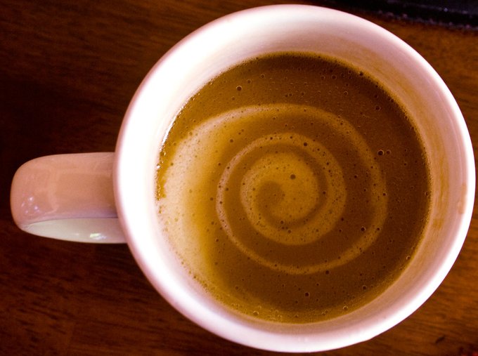
We're reaching serious levels of "coffee swirl" resemblance of the stratospheric
#polarvortex
today, thanks to the
#SSW
.
4
4
79
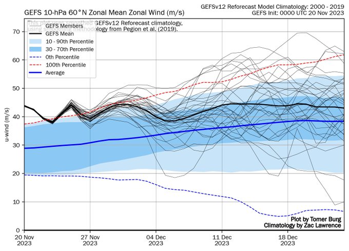
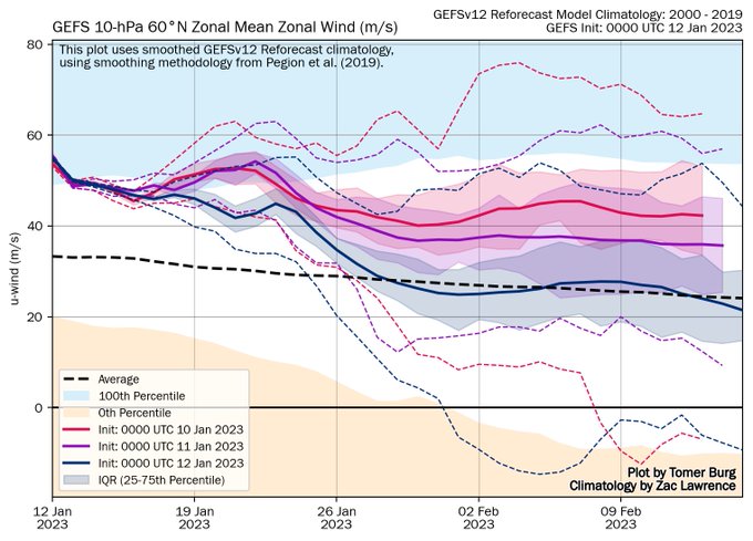
Appreciating
@burgwx
's stratosphere page today, especially with the new GEFSv12 climatologies from
@zd1awrence
! The current forecast has only a couple of members predicting
#SSW
, but the trend over the last few days has shown increasingly weaker zonal winds- great visualization!
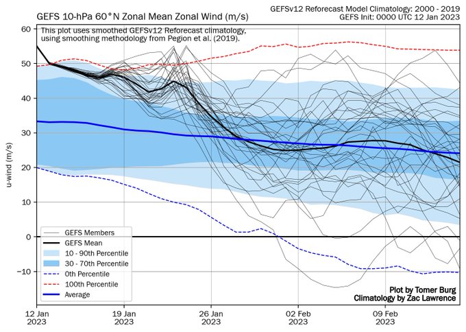
5
15
78
The stratospheric final warming happening today (10hPa, seasonal wind reversal to easterlies) has some nice wave-3 structure; a feature distinct from SSWs. I'll be talking about it at
#vEGU21
tomorrow Apr. 27 13:42 CET (way too early my time!)
@Domeisen_D
4
11
77
(1/2) At least a minor
#SSW
looks likely by the end of January, with most forecast models agreeing on ~30 m/s deceleration over a 6 day time period; however, whether we can get a full reversal of winds will need continued wave forcing which remains to be seen.
2
17
76
This is something I've seen before. Prior to
#SSW
, model fails to see any impacts. Once disrupted
#polarvortex
is initialized into forecast, suddenly the forecast is for basically the composite (historical mean) SSW pattern. (These are all forecasts for Feb, but diff init dates).
3
12
76
Southern hemisphere final warming of the
#polarvortex
underway! As I mentioned, if this verifies, it will be the 2nd earliest FW date in the SH on record since 1979.
2
30
72
5
5
74
A good indication of stratosphere-troposphere coupling is the deceleration of lowermost stratospheric winds. It's definitely not getting there in a hurry but headed in the right direction!
#SSW
#polarvortex
6
15
72
(1/4) The stratospheric
#polarvortex
looks to reform after the
#SSW
, likely leading to a late, primarily radiatively-driven, final warming.
2
9
74
It was such a pleasant experience to do this interview- my first with the NYT! (with
@judah47
and
@JFrancisClimate
) Forecast: Wild Weather in a Warming World
6
19
73
(1/2) This is a really cool image because you can see a filament of PV breaking off of the lowermost stratospheric
#polarvortex
across N. America. Hard to say whether this filament is related to the
#SSW
but interestingly you can see a mirrored filament in the mid-stratosphere.
5
17
73
(1/) This plot in a 2020 paper w.
@splillo
,
@zd1awrence
, +
@SimonLeeWx
is interesting in the context of an active MJO and upcoming
#SSW
. Shading of dots shows value of *minimum* NAO in the 45 days after each observed SSW, where the date of the SSW is plotted in MJO phase space.

2
17
72
This is a potentially exciting turn of events. We will see if it holds over the next few days.
#polarvortex
❄️❄️❄️
9
29
70
Massive heat flux at 10 hPa predicted in GFS, in agreement with most other models, but will it be enough to get a major
#SSW
? Definitely going to be a significant perturbation either way, but at >10 days out it's hard to say for sure yet.
3
13
70
(1/n) It was really really dry yesterday in
#Boulder
/
#Denver
... and one reason why? We were visited by a strong intrusion of stratospheric air, where there is very little water vapor!
#cowx

4
26
71
I'm excited about this blog post! Check out the awesome schematic that the team put together to show how a disruption in stratospheric polar vortex winds makes its way down to the surface. & then read the post for the explanation of what is going on now!

The latest edition of the Polar Vortex Blog has dropped and this week our experts explain how a major disruption of the polar vortex WAY up in the stratosphere can (but not always) impact the weather we feel at the surface.
3
58
167
2
12
69
So many people with the window seat shut the shades and the view is literally the best part about flying.
#cloudfan
2
7
68
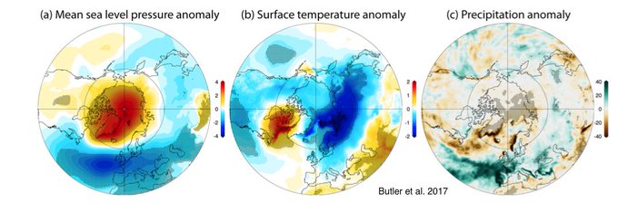
What are possible impacts of
#SSW
? From our SSW compendium (), this plot shows the anomalous mean sea level press, temp, and precip averaged for 60 days after every historic SSW event.
6
13
68
(1/n) Thought I'd update this plot since I'm getting retweets of older versions. I've added/changed some things; here using NDJ QBO 50 hPa and Nino 3.4 from CPC. Solid dots = corresponding winters (Nov-Mar) with SSWs, empty dots = winters with no SSWs. SSW = sudden strat warming.
5
13
68
A split of the lower stratospheric
#polarvortex
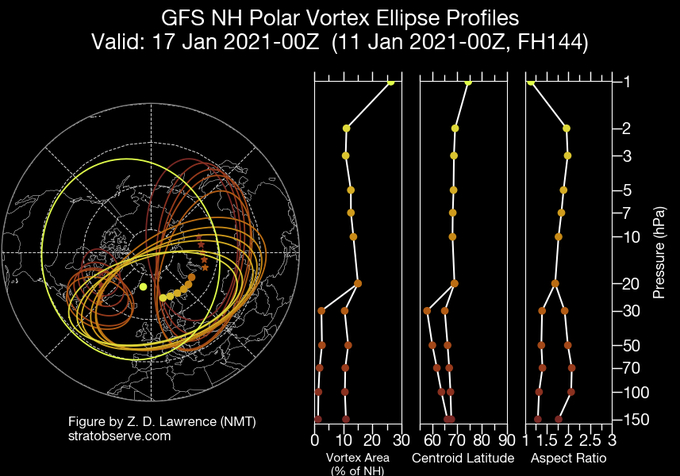
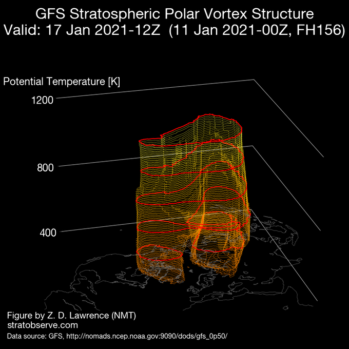
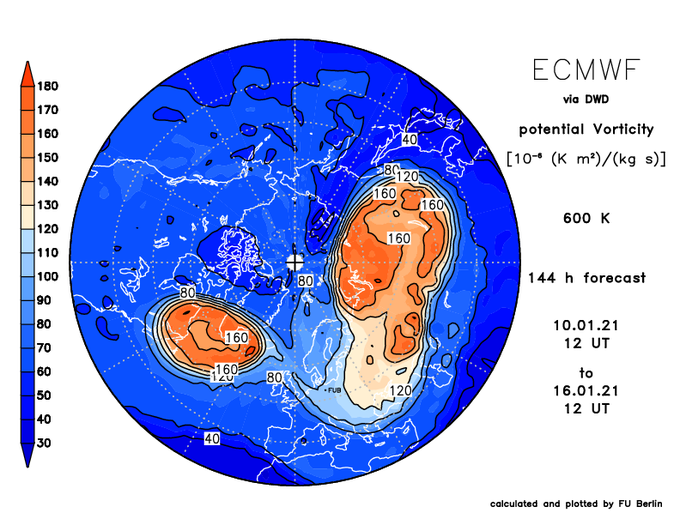
up to ~30 hPa looking more likely in both GFS and ECMWF forecasts by ~Jan 15th, with smaller lobe heading off towards eastern Canada.
1
17
69
In both hemispheres the stratospheric
#polarvortex
is experiencing a dearth of tropospheric wave forcing; this looks to soon change in the Northern hemisphere. In the Southern Hemisphere I expect we'll see the transition of the polar stratosphere to its summer state in ~14 days.
3
14
68
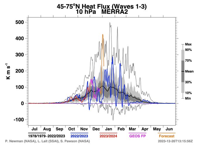
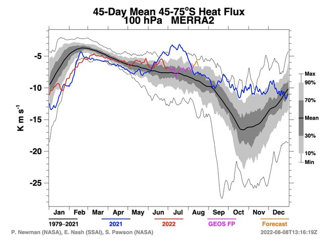
According to GEOS/MERRA2, the historical record for eddy heat fluxes (since 1979) was just broken. These represent the waves that help drive the
#SSW
, which looks to be a record-setting event in a number of ways, at least in the stratosphere.
7
27
67
Excited for the upcoming
#SSW
tomorrow, which will occur despite somewhat lackluster tropospheric wave driving (eddy heat fluxes). Whether the vortex further weakens in another 10 days as some forecasts suggests may ultimately decide whether this event has much surface impact.
2
7
66
Record large polar vortex area, low vertically-propagating wave activity, and very cold temperatures are currently not boding well for the
#Antarctic
#ozone
hole this year; but still polar night to about 75S.
1
8
67