Judah Cohen
@judah47
Followers
28,279
Following
4,242
Media
3,056
Statuses
31,704
Love snow & skiing. Always trying to push the boundaries what we can forecast about the weather on seasonal to sub-seasonal time-scales. My personal account.
Boston
Joined June 2009
Don't wanna be here?
Send us removal request.
Explore trending content on Musk Viewer
#PLdaGloboNão
• 468302 Tweets
Arsenal
• 444475 Tweets
Tottenham
• 299199 Tweets
Spurs
• 223691 Tweets
Maynez
• 101287 Tweets
インプレゾンビ
• 96802 Tweets
Ortega
• 81154 Tweets
Corinthians
• 60530 Tweets
Ange
• 53430 Tweets
Menem
• 51216 Tweets
#虎に翼
• 45959 Tweets
Romero
• 39349 Tweets
West Ham
• 33014 Tweets
Harrison Butker
• 31818 Tweets
Fever
• 28509 Tweets
Caitlin Clark
• 26604 Tweets
Peñarol
• 26304 Tweets
Hulk
• 21990 Tweets
Gabi
• 19617 Tweets
#WNBA
• 16944 Tweets
Lunin
• 15311 Tweets
Petrobras
• 14740 Tweets
#VoleiNoSporTV
• 13124 Tweets
Yuri Alberto
• 11918 Tweets


Pinned Tweet

My interview this morning on The Weather Channel, discussing what else but the
#PolarVortex
! A preview of this week's blog.

We spoke with Dr. Judah Cohen, Director of Seasonal Forecasting at Verisk Atmospheric and Environmental, who developed an algorithm to predict cold and snowfall anomalies over North America during Winter:
6
15
77
30
30
227

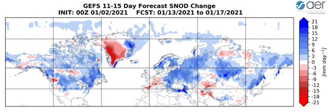
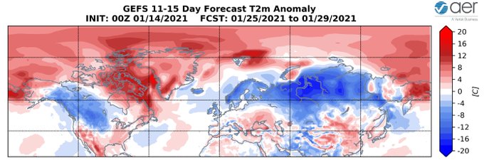
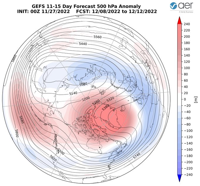
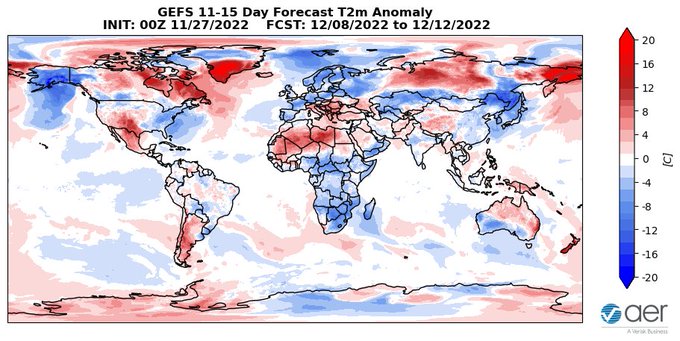
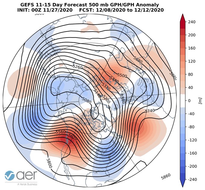
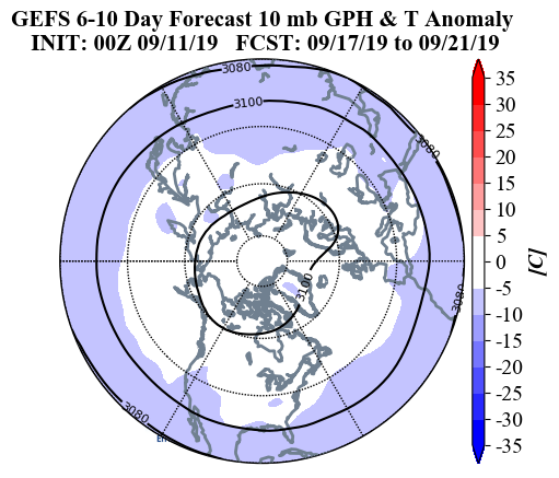
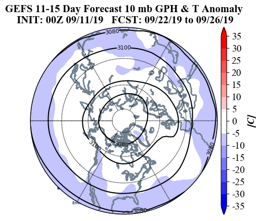
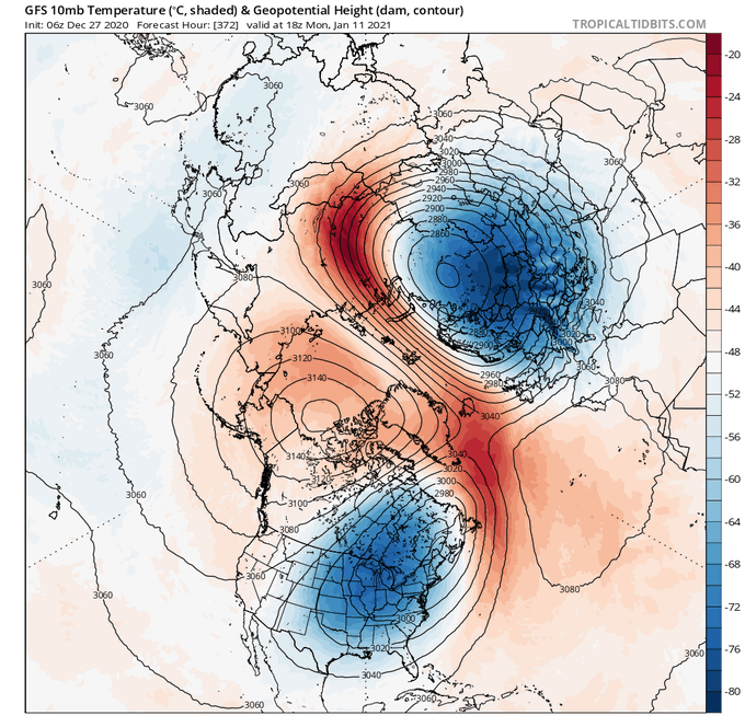
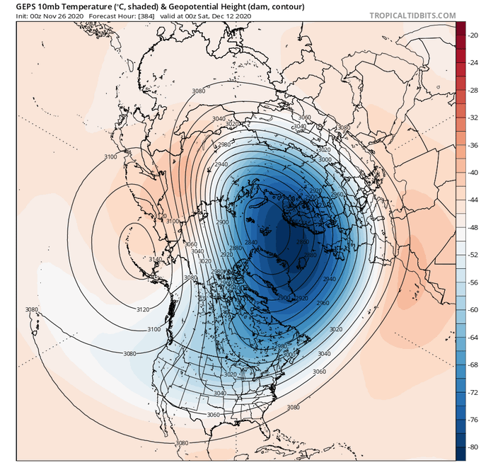
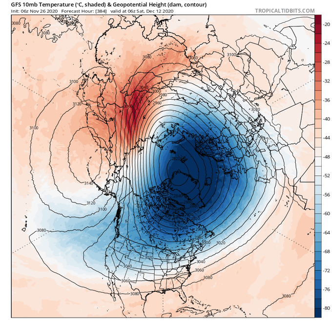
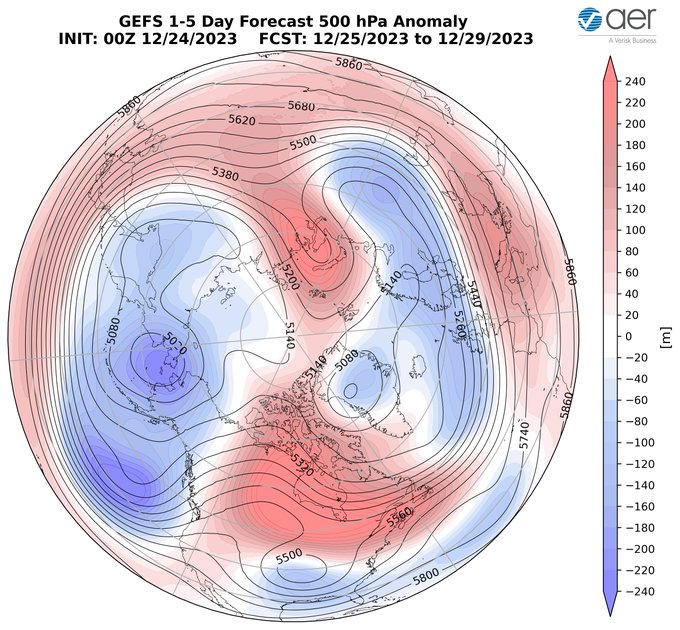
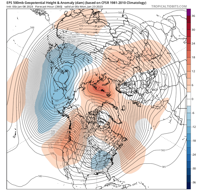
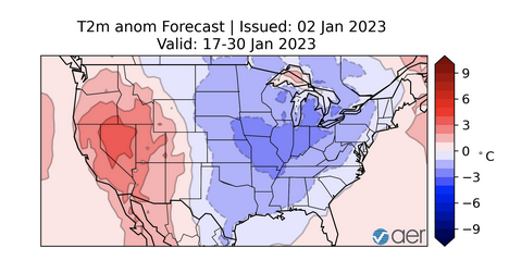
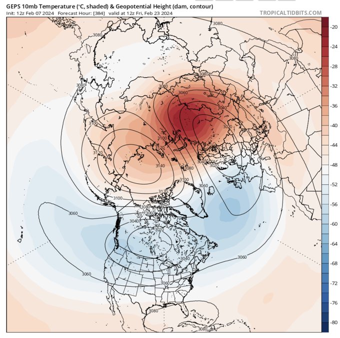
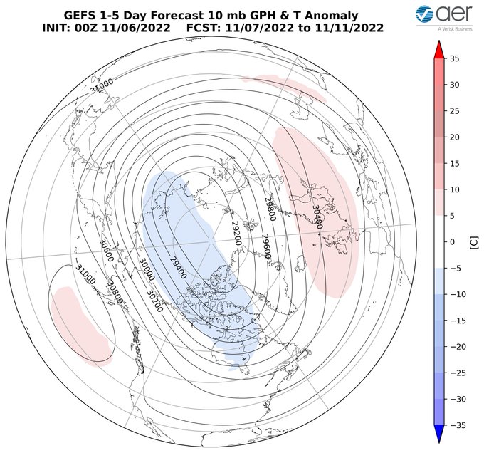
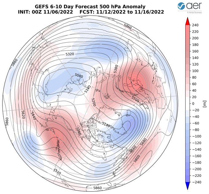
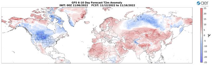
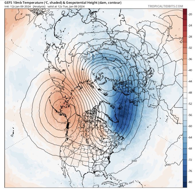
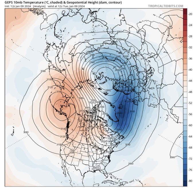
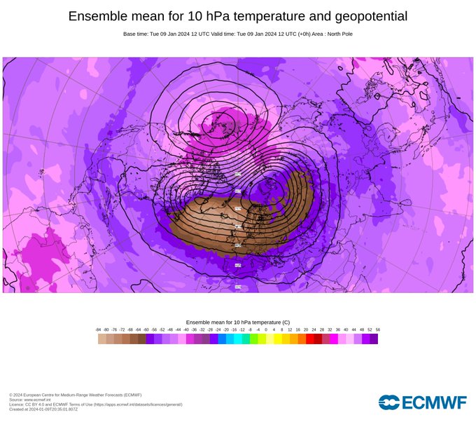
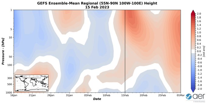
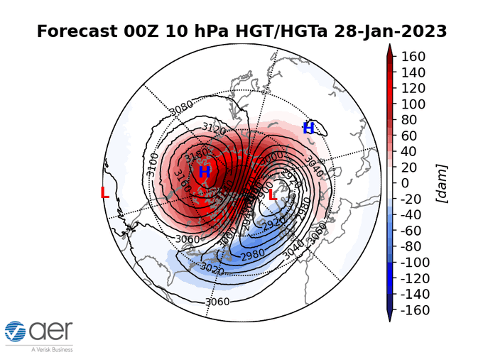
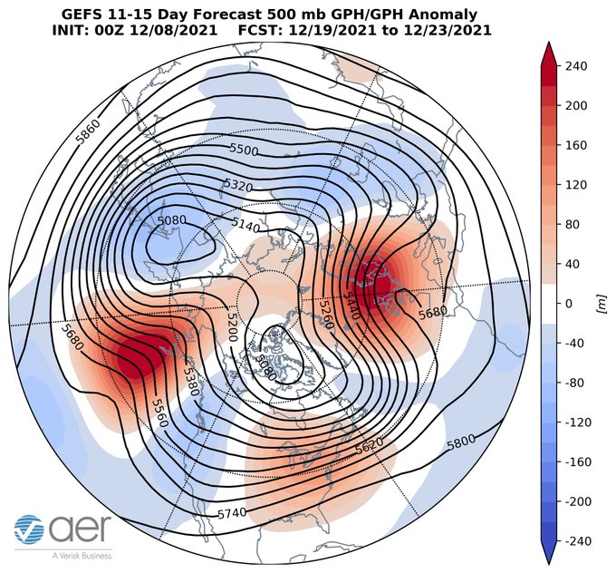
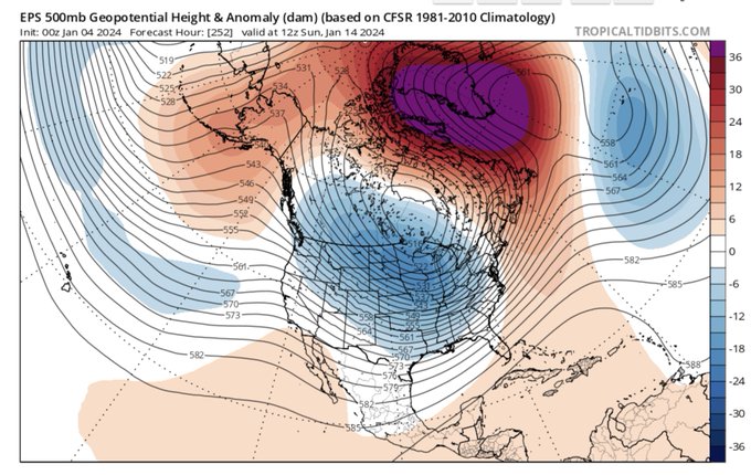
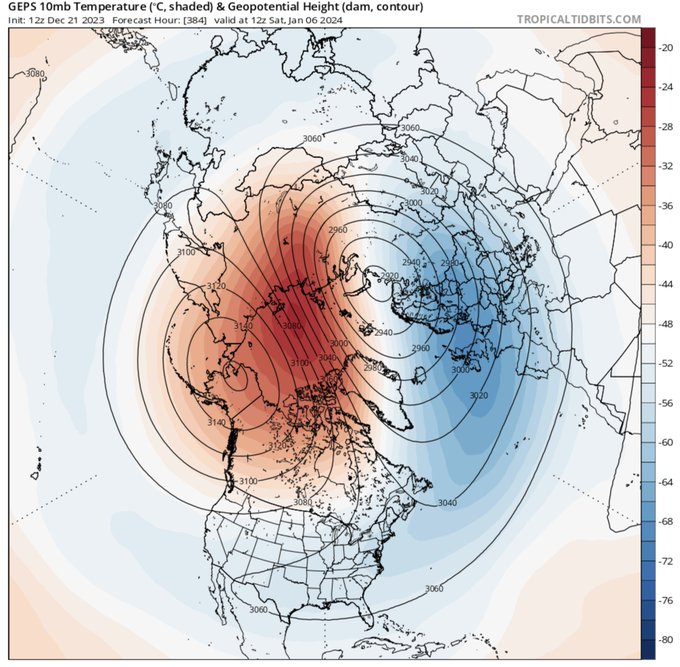
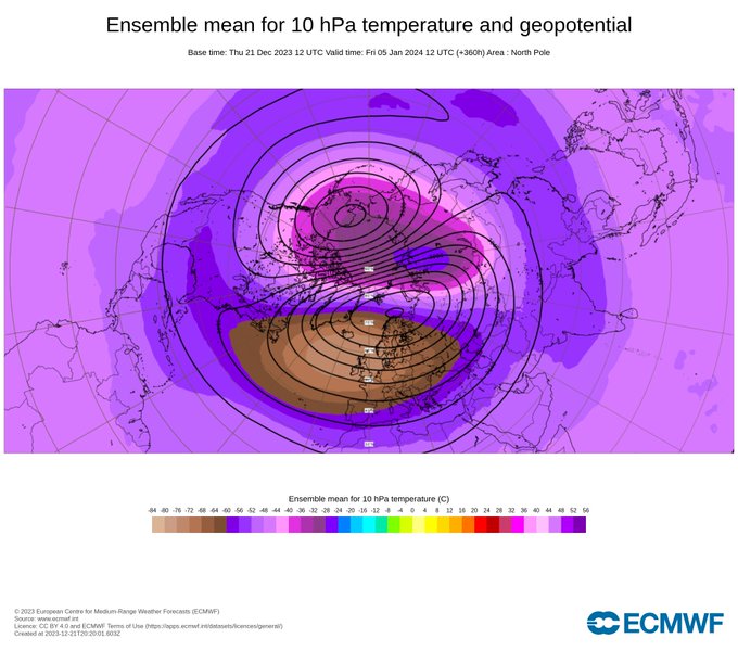
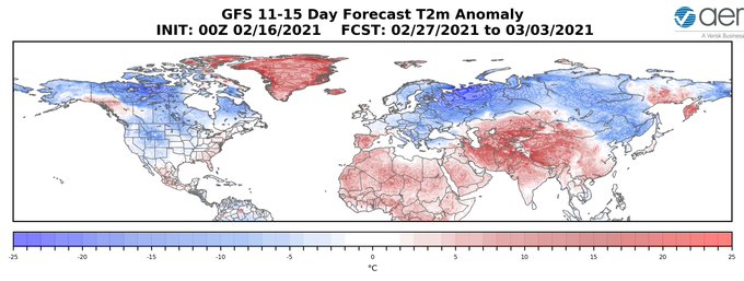
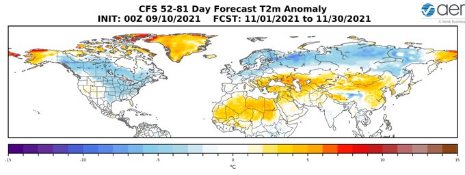
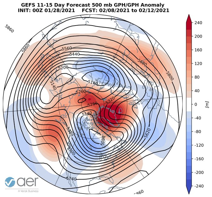
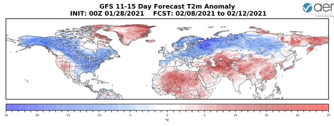
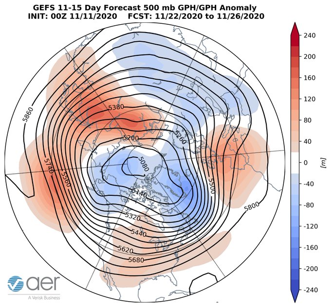
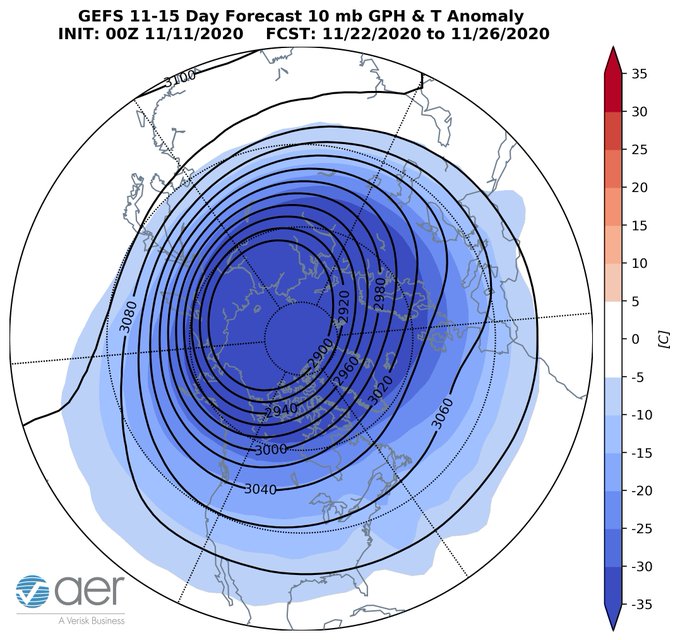
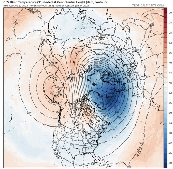
With high pressure across the Arctic & low pressure across the midlatitudes, GFS is predicting a textbook example of "Warm Arctic, cold continents" pattern end of January. Good time to remind everyone of my review paper that was exactly one year too early:
23
217
890
It’sssssssss Aliiiiiiiiiive! The
#polarvortex
has awaken from its summer slumber. It’s been a rough summer for many but the first sign that
#winteriscoming
.
34
75
504
Happy
#PolarVortex
split day! This is looking like the split that keeps on giving, long lived event with three distinct daughter vortices meandering across the mid-latitudes. If you are a
#winter
weather enthusiast I can't think of a better way to kick off 2019.
59
155
443
My confidence in a stretched
#PolarVortex
is growing as predicted Ural blocking is more favorable and upwelling energy is now predicted to reflect downward. Colder weather in the Eastern US is becoming more likely after next week’s torch.
51
42
412
In the real world sometimes it snows and sometimes it doesn't. And as disappointing as it is when it doesn't
#snow
, we will always have the happy hour/pub run model aka the 18Z GFS to delude ourselves that snowpocalypse & snowmageddon will soon fulfill all of our dreams.
47
28
387
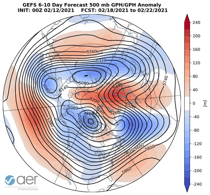
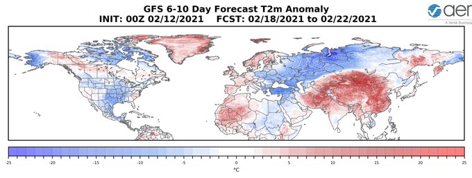
"Holy negative NAO Batman!" The GFS is starting to predict a classical negative North Atlantic Oscillation pattern with strong Greenland blocking. The pattern has been elusive of recent winters but will it couple up with the North Pacific block to party like it's 2010/11?

69
63
373
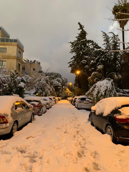
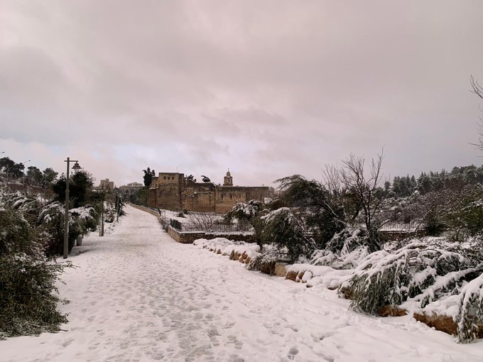
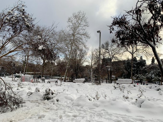
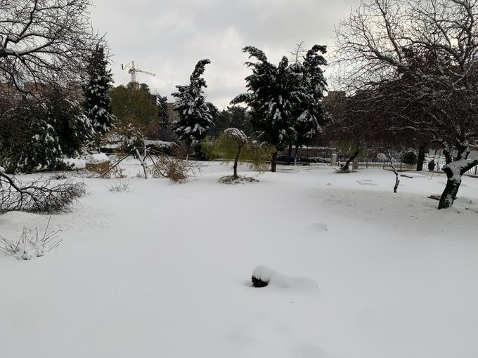
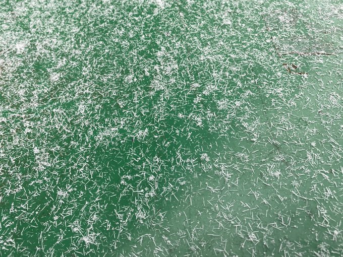
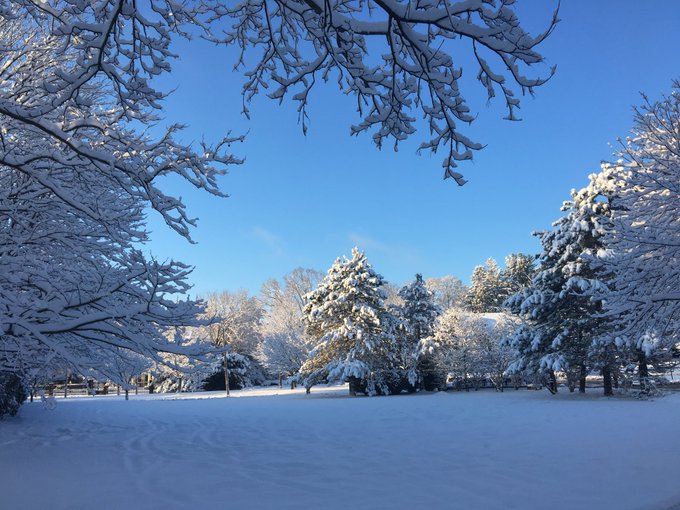
Some pictures of
#snow
in Jerusalem this morning, about 20 cm courtesy of my sister
@cohen_tova
22
66
370
Suspense over! Goliath wins 99 out of 100 times & the GFS has now caved to the ECMWF with both models predicting strong Greenland blocking. In the short term this increases the
#cold
risk to the Eastern US & especially Northern Europe. But what about long term? New blog tomorrow
35
62
356
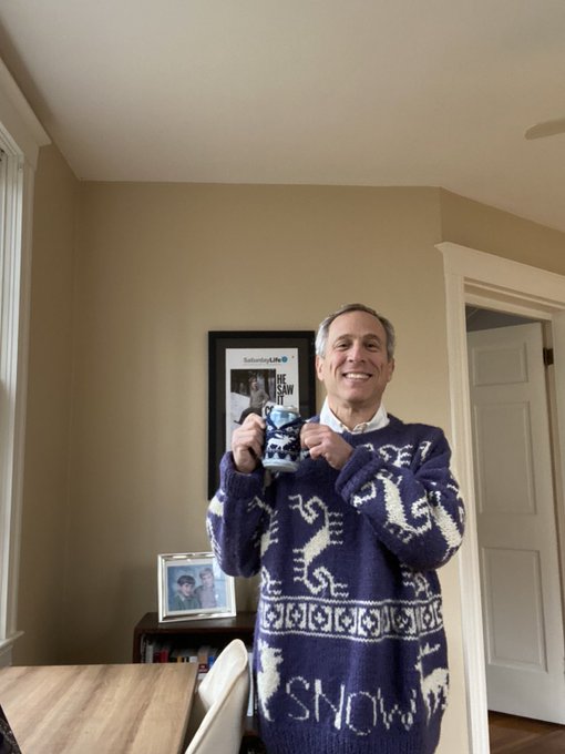
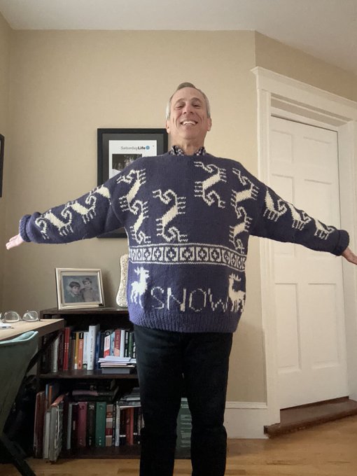
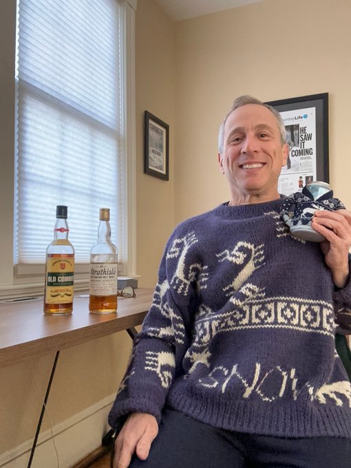
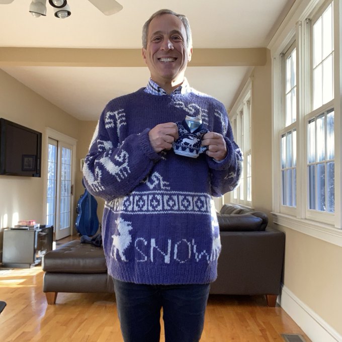
I have the
#snow
sweater on in full storm-preparation mode but know that I am a Sabbath observer so no electronics (
#wxtwitter
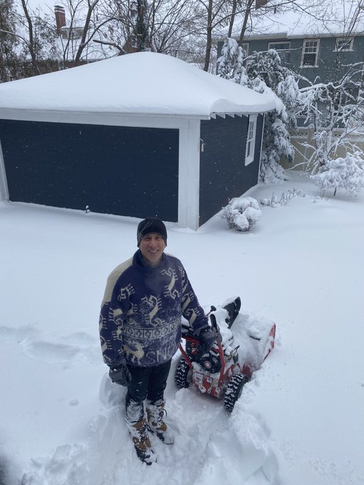
) & will be enjoying the storm old school walking in it & looking out my window. Best of luck to everyone with the storm & speak to you on the other side!

48
11
350
For all those on
#WxTwitter
who say that my
#snow
sweater and blower are the reason for the lack of snow, I think we can agree the curse is dead.
29
9
346
Looks to me we're on track for another
#PolarVortex
stretching event for 2nd week of January that typically delivers more wintry weather to Eastern US but could there be more? Blog returns next week just in time for the official start of
#winter
(at least in
#Boston
) MLK weekend!
36
58
348
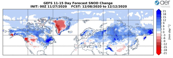
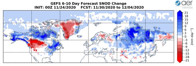
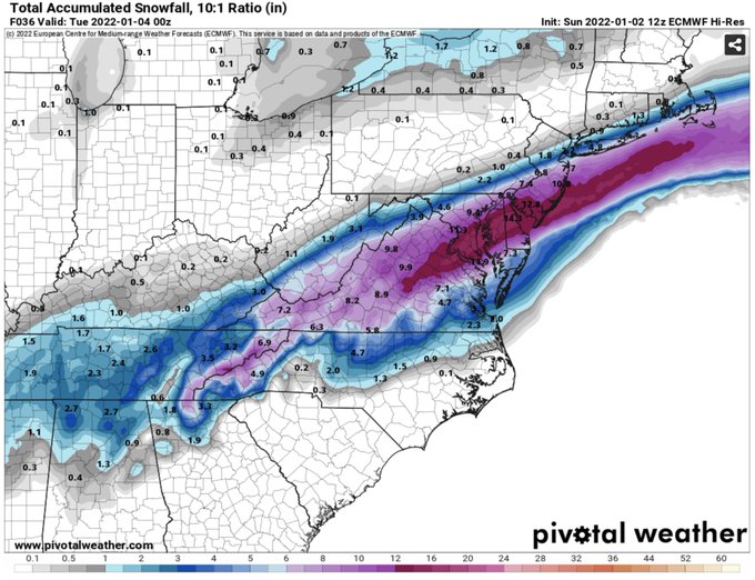
Second & third weeks of December could potentially be a prodigious period for snowfall in the Northeastern US & Southeastern Canada as ridging in Western North America delivers the cold & ridging in North Atlantic slows the forward movement & blocks storms from running out to sea
32
51
330
It's baaaaaack! GFS predicting the formation of the
#polarvortex
over the next couple of weeks.
#winteriscoming
love it or hate it.
43
78
319
Overnight models still appear to me to suggest the increasing possibility of a stretched or reflective
#polarvortex
event that drives
#cold
air into Canada & US. Attached are Canadian ensembles and GFS. Happy Thanksgiving!
44
35
316
Just when I was ready to call the end of
#winter
the GFS serves up this
#PolarVortex
split (and it does seem to me to have support of the ensembles). Legitimate or just Lucy teasing Charlie Brown with the football one more time?
57
37
329
What's better than twin daughters? Triplets of course! GFS predicting that the
#PolarVortex
will split into two then three daughter vortices. Upcoming PV disruption looks to be on the magnitude of 2018 and 2019.
30
42
308
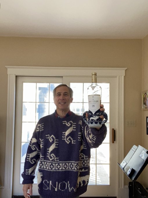
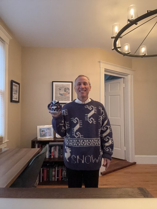
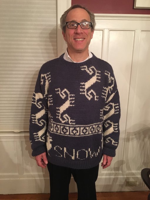
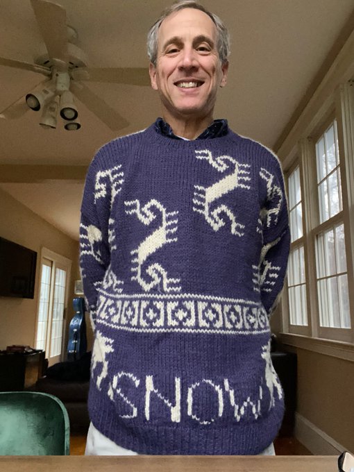
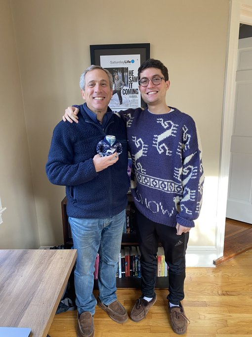
After seeing the latest snowless GFS forecast I decided desperate times require desperate measures so I have donned matching
#snow
/reindeer sweaters on myself and on my beer courtesy of
@BuschBeer
. They’re staying on until it snows.
54
10
293
Our
#MachineLearning
learning model has been down for a few days so I took a double take when I saw this morning's forecast for the New Year's period. This is the coldest forecast for the US that I can recall from the ML model, though it's only been running for two
#winters
now.
29
41
289
It's baaaaack! Ural blocking (UB) predicted to disappear has come back in model forecasts bringing along its partner wave-2 (did I say that I love wave-2). UB & wave-2 responsible for both
#polarvortex
(PV) stretching & PV splits. New blog Tuesday, this is for the all the marbles
37
39
280
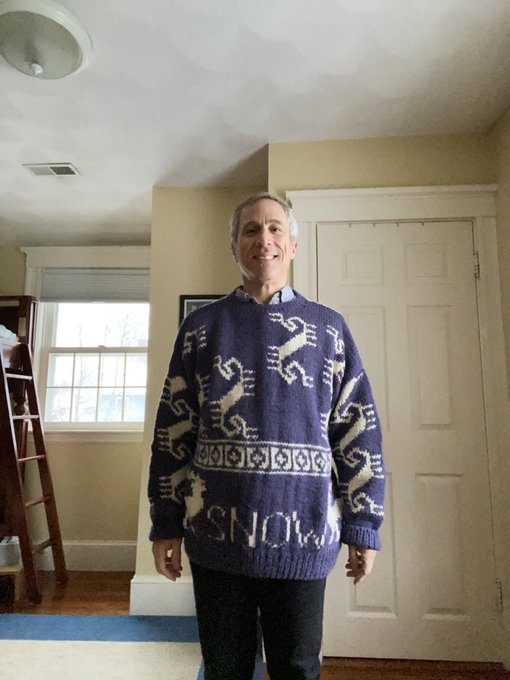
I think I send this tweet every
#winter
now “desperate times require desperate measures” I’ve been holding off but the I95
#snow
drought has broken me. Wearing the
#snowsweater
today as I update the blog whose message is “it is always darkest before the dawn.” There’s still hope.
36
10
283
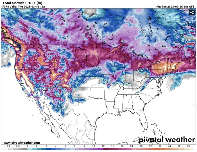
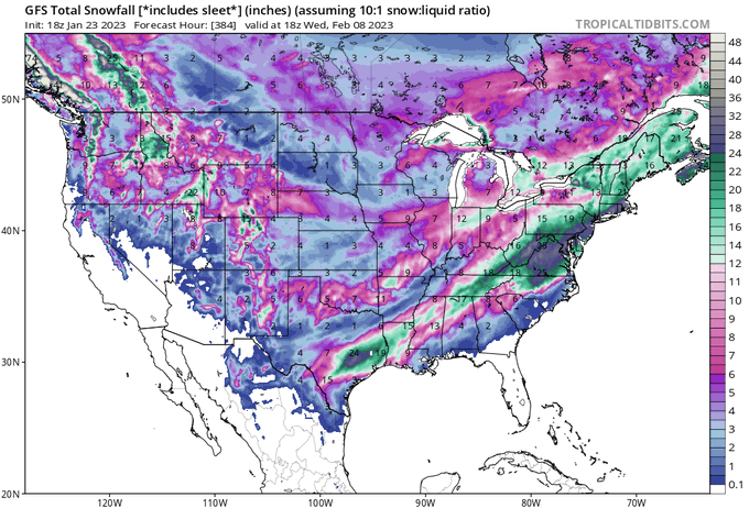
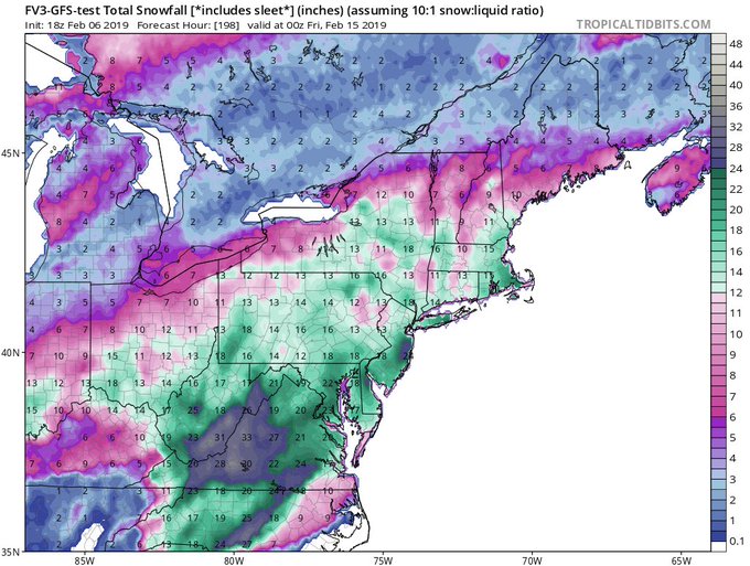
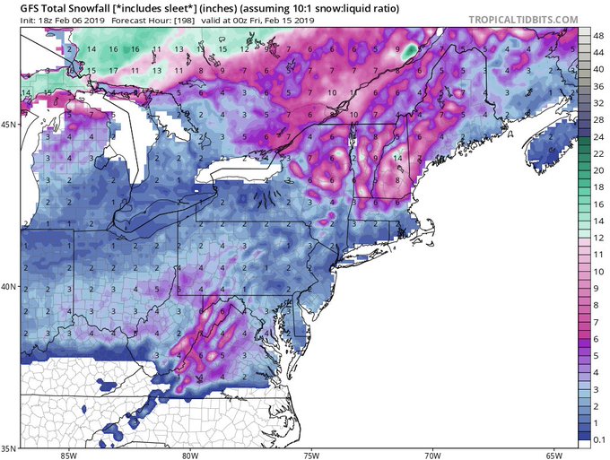
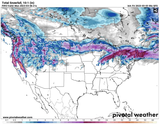
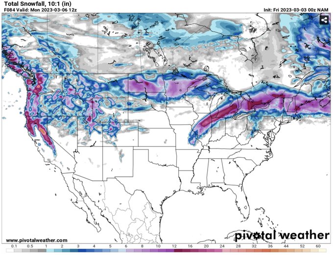
Here is the latest
#snowfall
forecast for forecast from the GFS ensembles. Not only does it show widespread risk of
#snow
across the Northern Hemisphere north of 40ºN but that is the best signal that I can recall for the
#UnitedKingdom
from my plots in a long time!
34
54
273
#PolarVortex
(PV) fans - what is better than one WAFz upward pulse? Two WAFz upward pulses! This is what GFS is predicting for the remainder of December & should lead to further weakening of the PV. The weaker the PV the higher risk of severe winter weather in January.
26
36
274
"If it walks like a duck, quacks like a duck, it's a duck." Models reversing & now showing a stretched
#PolarVortex
/wave reflection that brings colder weather to eastern North America.
#MachineLearning
model (has some timing issues) but has trended colder in East US for late Jan.
42
44
277
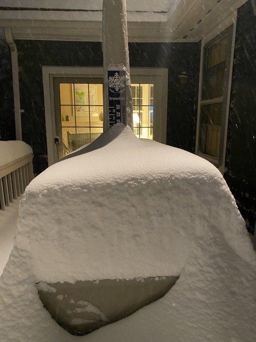
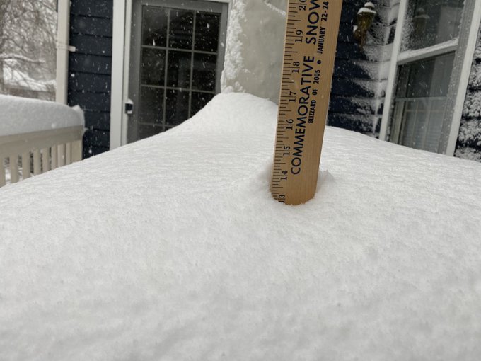
My patio furniture measurement shows 21 inches of
#snow
in Newton. Best March
#SnowStorm
of my life!
#MAsnow
#blizzard2018
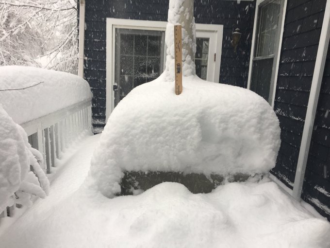
25
40
258
It's official Stratospheric Major Warming and
#PolarVortex
split! Second in two years. Both PV splits under different phases of ENSO, MJO and QBO. What is the same? High October Eurasian
#snow
cover extent and low Barents-Kara sea ice concentration both years. Coincidence?
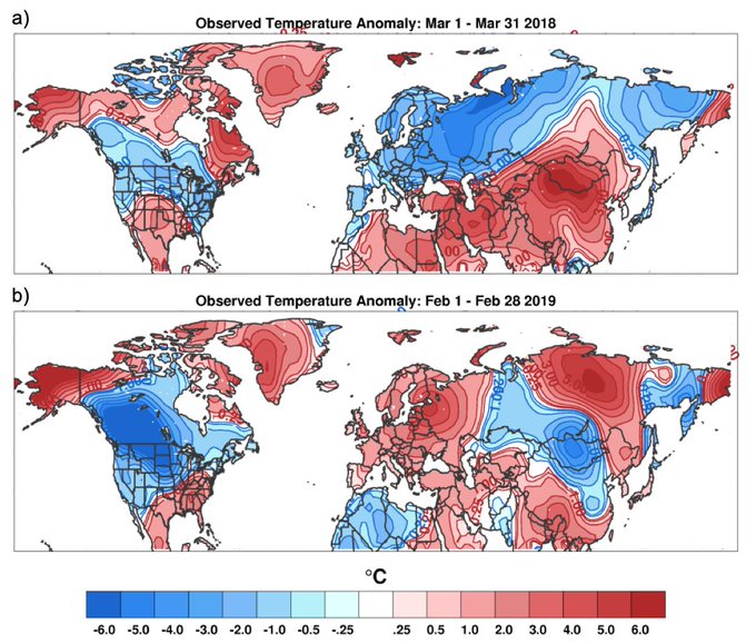
38
97
258
Holy Canadian Warming Batman! Clearly the ECMWF weeklies read yesterday's blog and are now full in on a Canadian Warming second week of December. Looking at this image I think that anyone can understand where the name comes from.
31
51
265
Looking at the latest ECMWF ensemble weekly forecast, I consider the forecast supportive of the potential for a sudden stratospheric warming as early as late January. Just my impression.
35
30
262
GFS predicting an anomalous early & possibly significant disruption of the
#PolarVortex
(PV) that will likely have important impacts on N Hemispheric weather heading into November. Lots to discuss in tomorrow's blog. "If there's something strange with the PV, who you gonna call?"
31
37
251
We have a winner! Canadian model first to predict a clear
#PolarVortex
split in the ensembles for the last week of February!. Other models are trending in that direction but Canadian is by far the most aggressive.
#Winteriscoming
(don't read too much into my warp sense of humor).
36
43
257
Drip, drip, drip. The atmosphere has sprung a leak and
#cold
air is dripping from the stratosphere to the troposphere (figuratively, not literally). Next drip is predicted in about a week & should bring much colder air into Europe from Siberia. Will be subject of tomorrow's blog.
25
54
248
I'm baaaack! And who is here to greet meet upon my return this week but my new best friend the stretched
#PolarVortex
with all the trimmings. It's good to be back and kicking it off with a new blog tomorrow. Did my absence make anyone's heart grow fonder?
40
13
248
I think it's mostly a curiosity for now but the most recent ECMWF weeklies was the coldest run for US & Europe that I can recall. Some variations but
#cold
lasts for most of next six weeks including week 6! I am really curious for the reason. Usually any cold is gone after week 2
26
38
243
My belief is that the relationship between
#snow
&
#climatechange
is not so much climate change=less snow but rather it exacerbates winners & losers/rich & poor. Impressive amount of snow predicted for the US this week & guess where will it fall, where it has snowed all
#winter
.
29
33
246
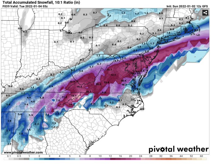
Lots going on blog & pending
#nor
’easter
#snowstorm
teetering between historical
#blizzard
& fish storm so I needed to bring out the big guns swapping in the matching
#snow
sweater the Budlight for my best bottle of
#scotch
. And if this goes south going to need the hard stuff.
27
4
243
It's official! There are two distinct
#PolarVortex
(PV) centers. Models say this is so much fun, let's do it again next week! Not technically a PV split (centers are not independent) but is a characteristic of a more extreme PV stretch, hence plenty of severe US
#winter
weather.
23
43
241
ECMWF weeklies have been all over the map in it's forecasts of the
#PolarVortex
but latest forecast is all in (at least in the mean) on a sudden stratospheric warming for early January with polar stratospheric warming centered on the North Pole (not based on zonal wind strength)
20
34
244
Just looking at today's weather maps now but this is nuts, GFS from this morning predicting yet a third
#polarvortex
split! But this time with major daughter vortex over North America. Not sure this will verify still entertaining to watch.
22
33
236
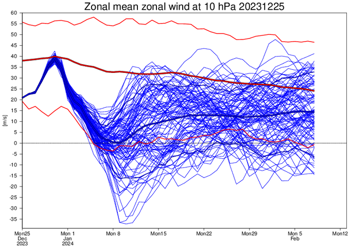
I am sure
#wxtwitter
thought I was joking when I said what is going on with the
#PolarVortex
is a nail bitter but it couldn't be tighter. +0.01 zonal wind it is a minor warming, -0.01 it is a major warming & the ECMWF ensembles are now predicting 0.0! The drama continues to build
31
33
233
I hope all the
#snow
lovers in
#Boston
& Southern New England appreciate my own personal & painful sacrifice to ensure the best
#snowstorm
in 2 years comes to fruition. It’s a tough job but someone has to do it! Please send pictures!!! Don’t worry blog later today.
52
7
237
Confidence is growing in a significant
#PolarVortex
disruption in the coming weeks. This could be the single most important determinant of the weather this
#winter
across the Northern Hemisphere. Likely impacts discussed in today's blog:
29
115
220
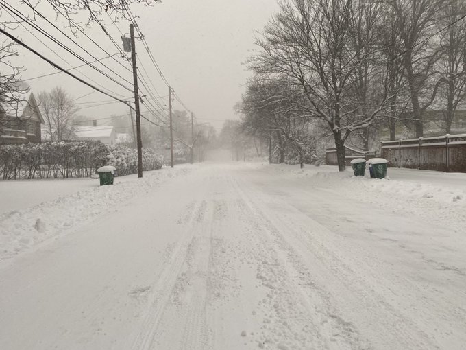
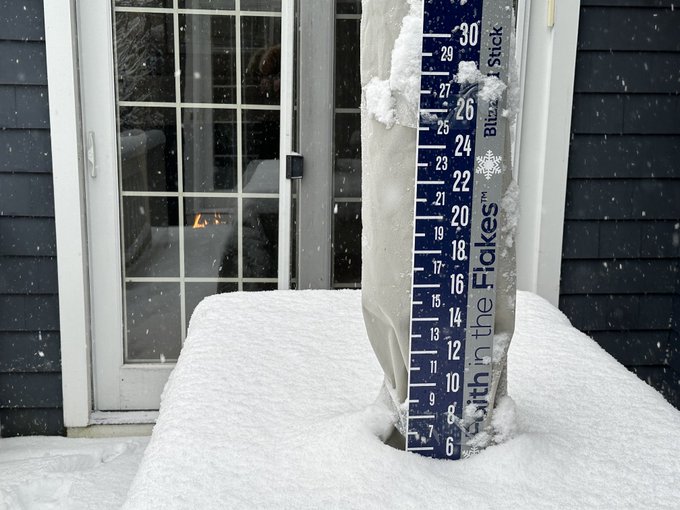
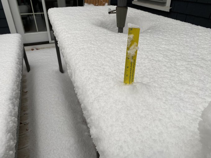
Close to 9 inches in Newton MA. I know I shouldn’t complain but there’s a foot+ just five miles away from me!
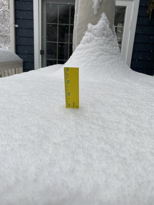
20
11
228
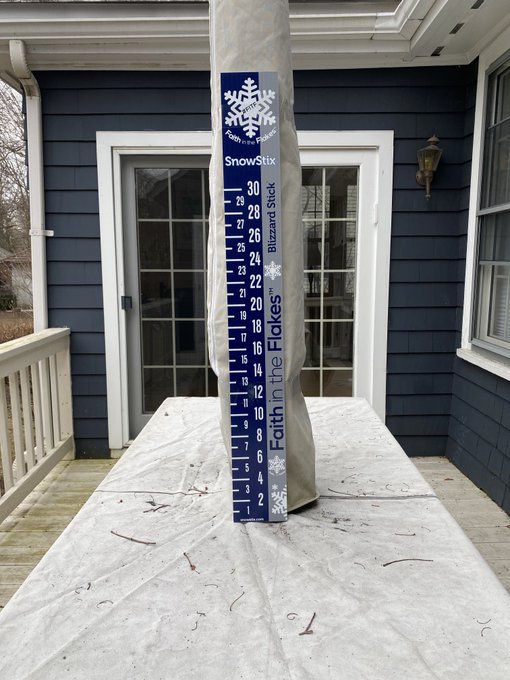
@JustinWeather
I got your beautiful
#snow
shield, I mean stick, in position for the big storm tomorrow, thanks!
41
7
227
"Houston,...The Eagle has landed." Well maybe not the distance from the earth to the moon but the GFS is predicting that impacts from
#PolarVortex
disruption currently at 70,000 feet in the atmosphere will reach the surface in two weeks. Blog goes public with update later today.
25
35
230
Boys & girls, you know what time it is? That's right sweater time! As in
#snow
sweater & my mini me beer sweater for reinforcement. Praying & hoping the GFS is correct but in case it all goes south & the NAM is correct, I brought out the big guns to make it feel better. A win-win
35
9
232
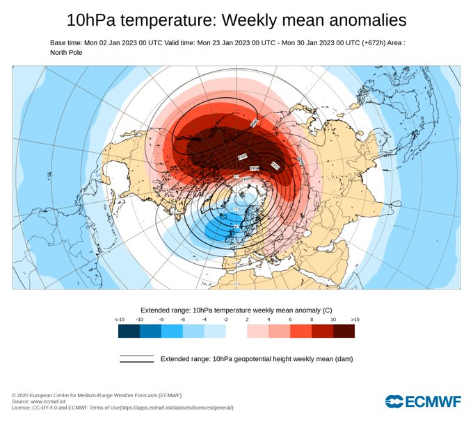
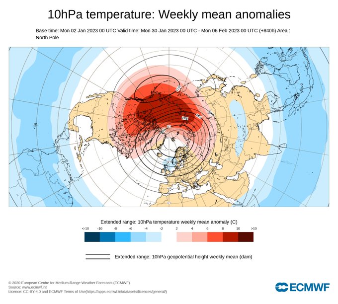
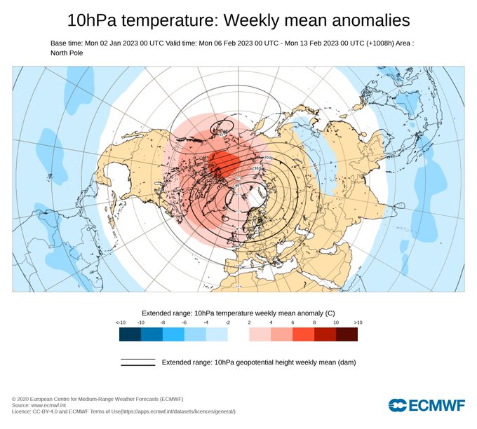
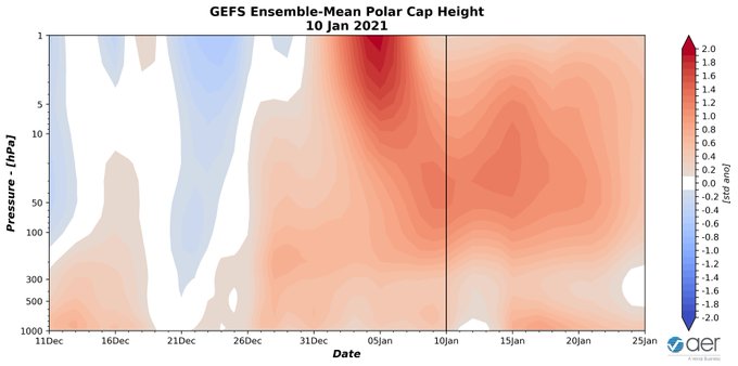
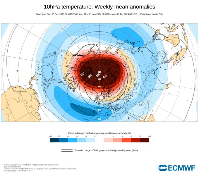
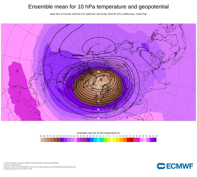
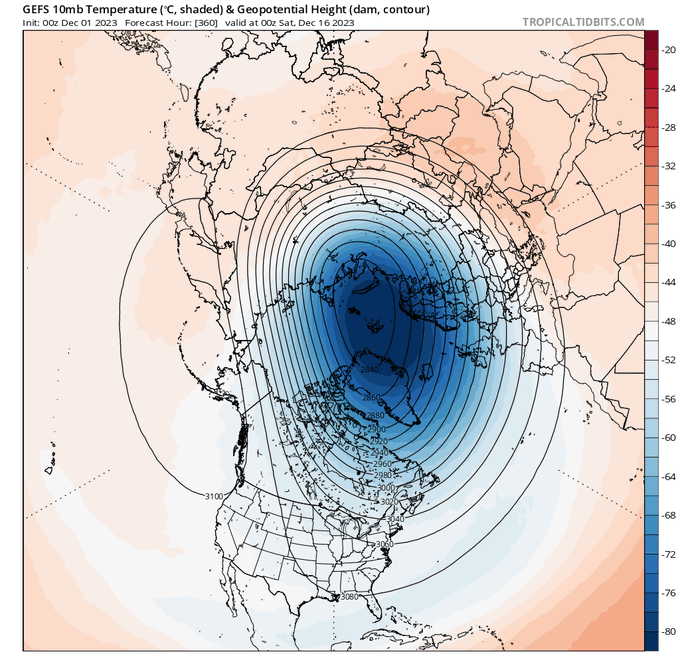
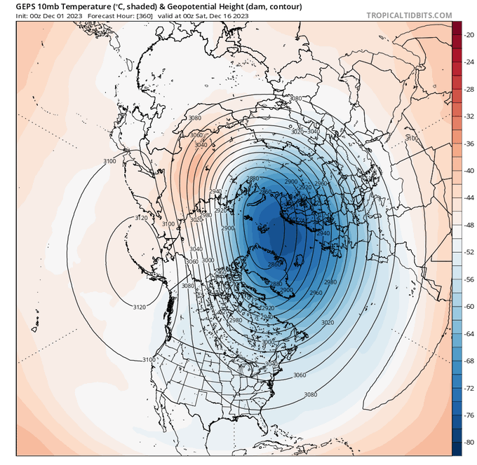
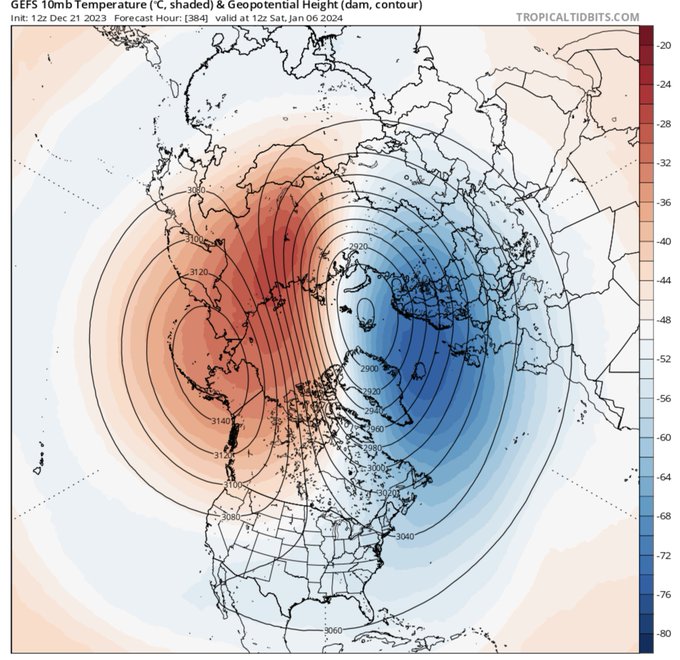
It has been a mild January for much of the Northern Hemisphere. The strongest sign the pattern is transitioning to colder is predicted warming/positive geopotential heights in the polar stratosphere, the first in two winters! This forecast can be volatile so needs to be monitored
13
32
226
And so it begins... Not the most exciting animation of the
#polarvortex
but you can see the beginnings of the formation of the polar vortex for the 2021/22 fall and winter season. After this summer's
#heat
, who isn't psyched for some
#snow
?
39
28
225
#Greenland
blocking is that really you? Winter-is the news of your demise premature? At least the GFS is drinking the sudden stratospheric warming Kool-aid. Can
#winter
snatch victory from the jaws of defeat? Obviously plenty of time for this to & not happen. Let the games begin!
34
24
228
Things are bigger in Asia! I crunched the numbers and
#snow
cover advanced 7 million sq km (from 13+ to 20+) across Central & East Asia the first week of November all south of 60ºN. That is comparable to the Contiguous US becoming snow covered in just one week's time.
12
51
220
Now that a major
#PolarVortex
(PV) disruption is imminent, in today's blog I discuss the schizophrenic response of the troposphere/weather to these events as exemplified by 2018 & 2019 & whether we should expect Dr. Jekyll or Mr. Hyde in the coming weeks:
22
39
219
It's baaaaaack! Ural/Scandinavian blocking (well at least on the GFS). Seems to be a tough character to nail down exactly but in the latest blog I discuss the implications to the
#PolarVortex
of the different plausible fates of the blocking:

30
26
218
A sudden stratospheric warming is looking more & more likely for early to mid-December. Our speculative
#PolarVortex
model predicts the potential for a major warming/disruption around December 15. I speak at
#AGU19
on December 12, I might spend my 12 minutes showing PV animations
25
72
213
The power of the sweater. I've been Debbie Downer about
#winter
weather prospects but the risk of a change to more widespread colder weather is increasing. GFS prediction of Alaskan-Scandi ridge-bridge could be a harbinger of a stretched
#PolarVortex
& colder weather for Asia, US
33
33
214
If you want to know what the models will predict tomorrow today read the blog: "the polar low that sits over Hudson Bay in winter could find itself along the US-Canadian border greatly increasing the risk of an intense Arctic outbreak or a crippling blizzard." Now in all models!
21
35
220
Looks to me like the ECMWF, GFS & Canadian models have all come around to forecasting a stretched
#polarvortex
for mid-December. No signs of a related pattern in the troposphere, i.e.,
#cold
air on the move across North America, but will models adjust in this direction with time?
27
30
217
Just last week I replied on Twitter that I will get excited for wintry prospects when the polar low drops south from the Canadian Archipelagos to Hudson Bay. Well this morning the GFS obliged. Predicted Polar low over Hudson Bay leads to colder weather and increased
#snow
chances
28
44
211
I rarely comment about sea surface temperatures (SSTs) but what is going on in the western North Pacific?! There has been recent research about ocean
#heatwaves
& those are ridiculous temperature anomalies over a large expanse of ocean. That's a lot of heat content for release.
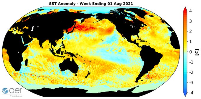
27
65
212
GFS ensembles growing even more confident in a
#snowstorm
for the Northeastern US in early December, especially in the interior.
#WinterIsComing
22
25
209
1/ As I write today's blog, the predictions for the mid-tropospheric circulation with increasing high latitude blocking especially near Alaska & deepening troughing in eastern N America could potentially yield the most active mid-winter pattern in the Eastern US since 2014 & 2015
44
41
212
Sometimes all you need is a good stretch. Looks to me that the ECMWF has capitulated to the Americans (GFS & me), all models now agree on a
#PolarVortex
stretch. Major warming still possible. I stand by my implications with what I wrote in yesterday's blog
26
31
212
GFS starting to shwo with more consistency the upcoming
#polarvortex
disruption influencing the tropospheric circulation. Should lead to more high latitude blocking and possibly
#colder
weather across the mid-latitudes in November.
15
35
208
"Daddy is it true that when you were a kid, sometimes the rain would be white, it would pile up on the ground, you could sled on it, you could make soft balls & throw it at each other & make people out of it? I wish I could experience it too!" Timmy sometimes dreams do come true.
32
16
215
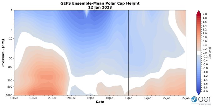
North Atlantic version of the polar cap heights (PCHs) suggests influence from the
#PolarVortex
may not be over with at least one more spike in troposphere PCHs in March favoring Greenland blocking & with cold air lurking increase the risk of severe winter weather in Europe & US
24
41
212
With the possibility of a significant
#PolarVortex
displacement increasing for mid-December, I believe one analog for winter 2019/20 moves to the head of the class. Read which one and my reasoning in the latest blog:
36
53
201
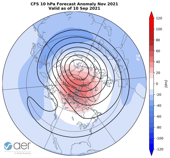
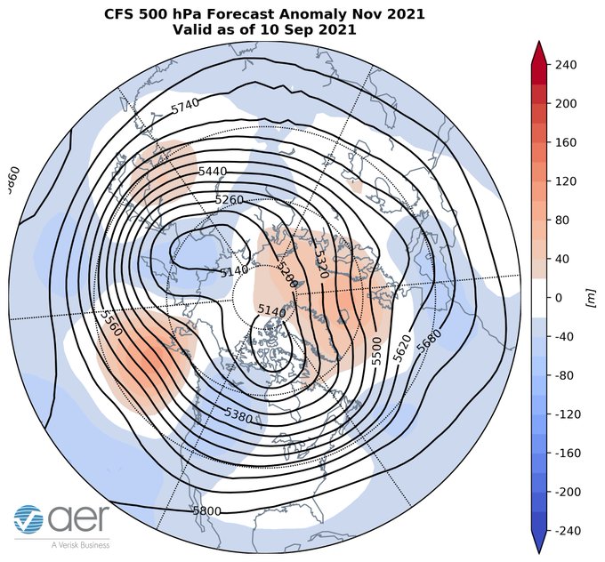
This is for entertainment purposes only but whatever the CFS is smoking this morning, I want some! What a November forecast, disrupted
#polarvortex
, Greenland & Gulf of Alaska blocking, widespread cold temperatures across northern Eurasia & eastern North America.
#Winteriscoming
27
23
206
Time to bring out the big guns! I am at stage 6 of 7 stages of grief for our
#winter
(stage 7 is morphine drip at the max), the
#snow
sweaters for me and my
@AnheuserBusch
. Weather maps have been soul crushing of late but trying my best to make lemonade out of lemons 🍋
30
4
208
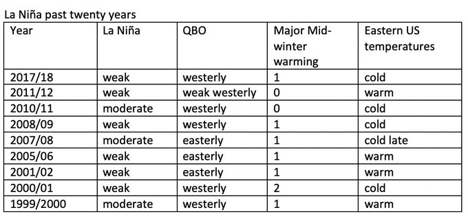
La Niña is thought to favor a mild
#winter
in the Eastern US but recent La Niñas feature many large
#polarvortex
disruptions which is often followed by severe winter weather not only in the Eastern US but elsewhere across the Hemisphere:
35
50
206
If you're looking forward to spring weather in the Eastern US, next weekend is going to hurt, looks
#cold
possibly even record cold. I'm advocating December be replaced by March in the winter month club. Though not sure "I am dreaming of a white St Patty's Day" has the same ring.
30
47
205
The GFS is predicting that the major daughter
#polarvortex
will be centered over Canada (until now has been over Eurasia), a relatively unusual event though happened last February. Could be suggestive of building of extreme
#cold
air across North America but especially Canada.
25
52
198
Weather models predict the "Dream Team" of high latitude blocking centered over Alaska, Greenland & Urals/Barents-Kara Seas for
#winter
weather in the Eastern US, Northern Europe & East Asia. Individually each is a superstar but can they play well as a team on the court together?
22
32
208
Woo-hoo! Second surprise
#snow
of the week here in
#Boston
! This time models never predicted it. Has the
#polarvortex
disruption finally turned the tide?
27
12
210
I created a video that tries to explain the connection between
#Arctic
change, the
#PolarVortex
and severe
#winter
weather including
#snow
and
#cold
. The occasion of
#PolarVortex2019
seems like a good time to release:

23
89
207
Well hello there, welcome to America! The US could possibly get a rare visit from the tropospheric
#PolarVortex
where the core of the
#coldest
air in the Western Hemisphere crosses the US border from Canada next week. The weather knows no borders.
29
26
197
Cancel
#winter
! Now that I have your attention, first I wouldn't cancel winter second week of November but the predicted pattern has almost no redeeming qualities if you are a winter weather enthusiast, ridging in the ocean basins, no high-latitude blocking & strong
#polarvortex
.
47
37
197
That is one fine looking stretched
#PolarVortex
the GFS is predicting. And perfect timing coinciding with Cohen's official first day of
#winter
. What the polar vortex taketh away (split) the polar vortex giveth (stretch).
33
20
201