

Brian McNoldy
@BMcNoldy
Followers
29K
Following
38K
Media
5K
Statuses
19K
Senior Research Associate at the Univ. of Miami Rosenstiel School. Hurricanes, climatology, & sea level rise... mostly. 🏳️🌈 Find me on 🦋!
Joined June 2012
I have no words. what a tremendous surprise to see this morning from @MiamiNewTimes . Best Meteorologist?!?! Thank you!

73
43
832
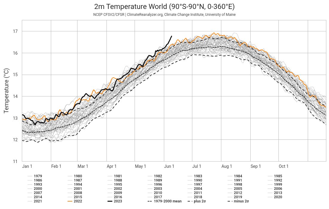
I know there are a million people sharing temperature anomaly charts and maps lately, but there's a good reason for that. This is totally bonkers and people who look at this stuff routinely can't believe their eyes. Something very weird is happening.
212
2K
5K
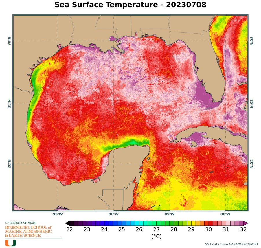
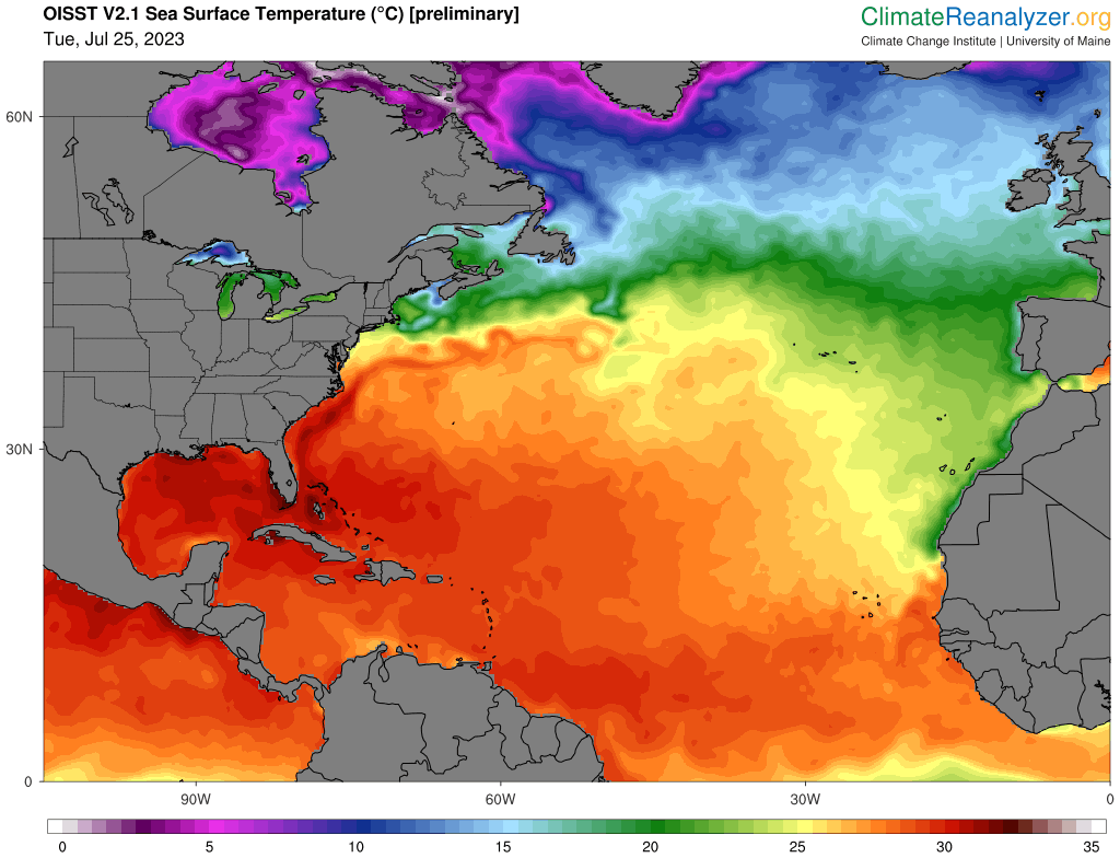
Ok, not sure I've ever seen the water around Florida look quite like this before. at any time of year. 😬
248
808
3K
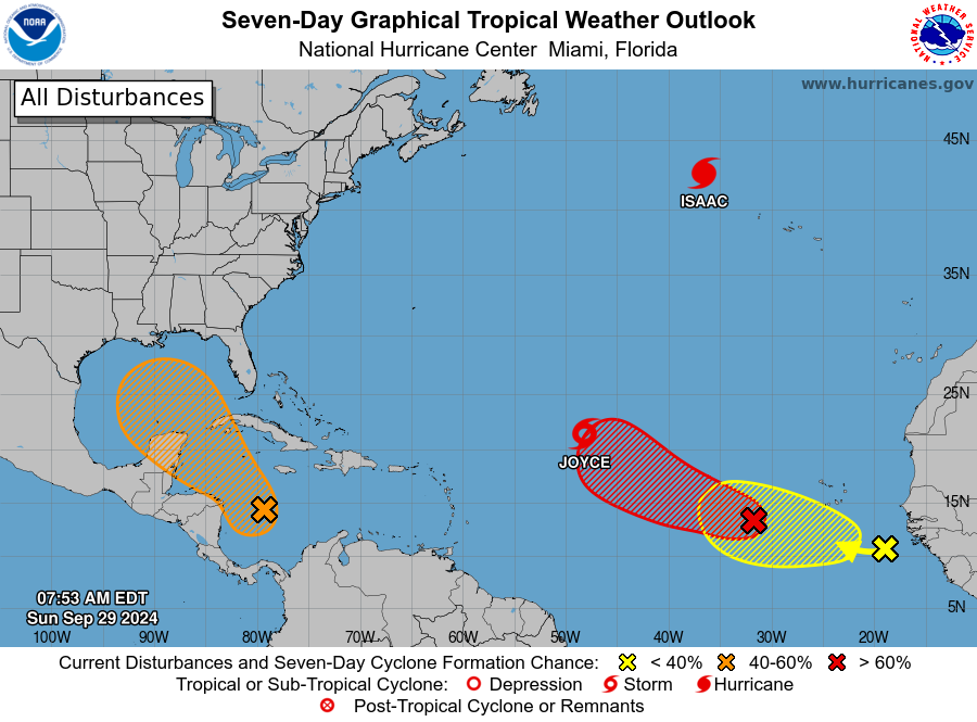
The trend is not our friend. Odds are increasing of another storm developing in the western Caribbean on Tue-Wed then tracking northward into the Gulf on Thu-Fri. A track toward Florida is what the models have been showing, with a possible landfall on Sat-Sun. Stay tuned!!
48
568
2K
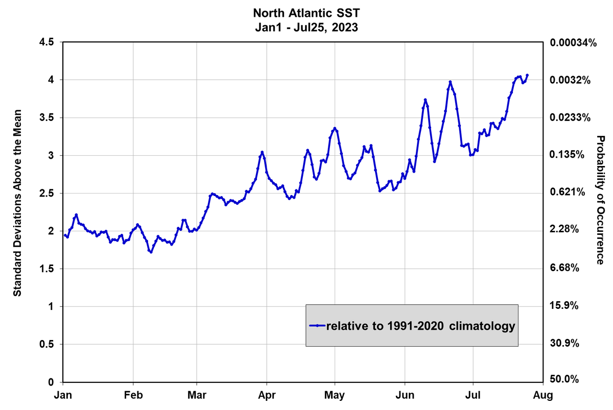
Unbelievable: the North Atlantic sea surface temperature is now 4.5 standard deviations above the recent 1991-2020 climatological mean. that translates to a 1-in-284,000-year event. Yet here we are watching it unfold, one day at a time. This is deeply troubling.

179
921
2K
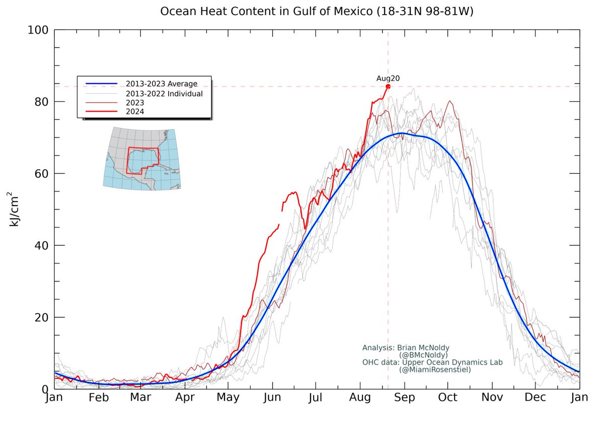
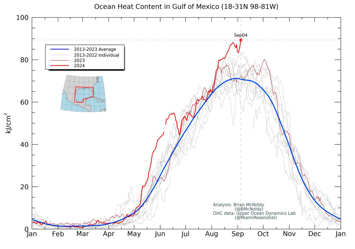
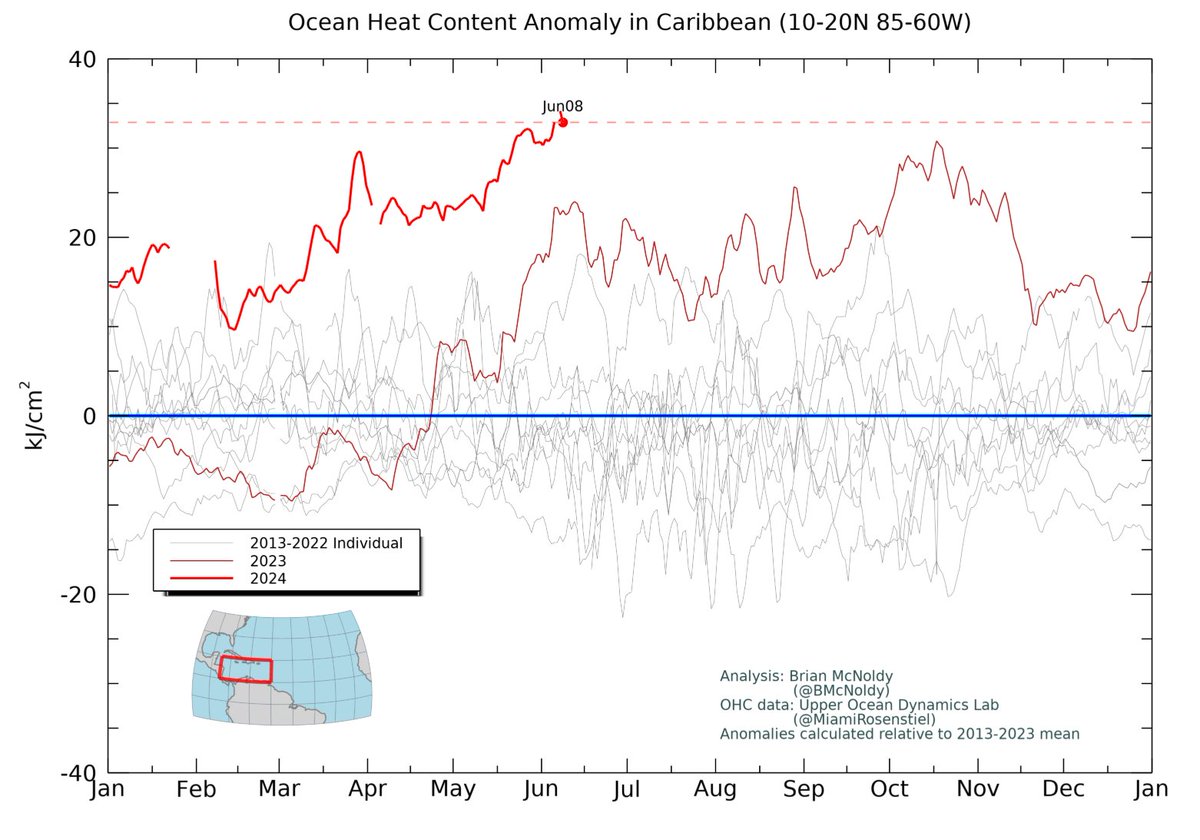
And there it is: the highest ocean heat content in the Gulf on record.
166
775
2K
This has to be a once-in-five-lifetimes event. Totally insane.

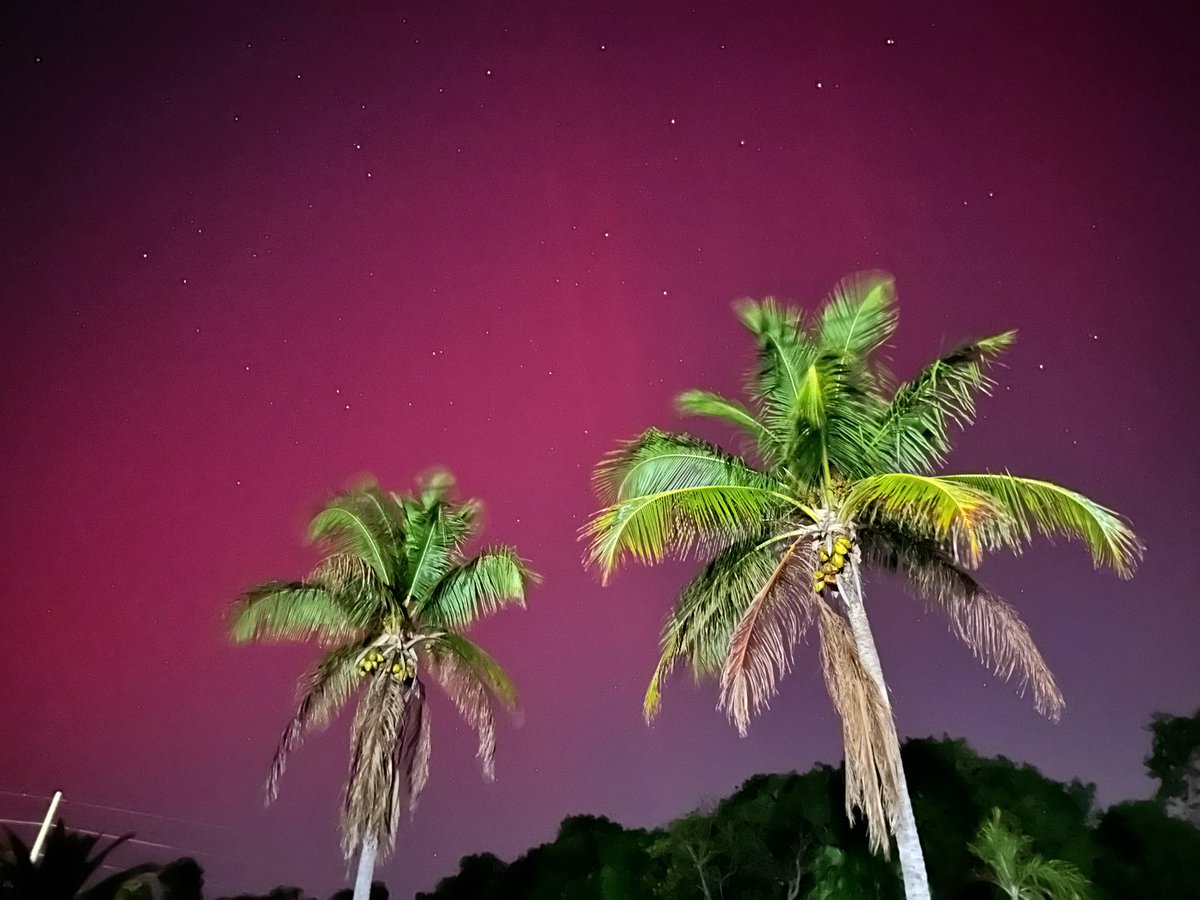
Northern Lights RIGHT NOW over #KeyLargo Florida, this is insane to see the Aurora Borealis so far south !
15
139
2K
This is pretty amazing: the ocean heat content averaged over the Gulf of Mexico is obliterating previous all-time record highs. It's 126% of average for the date.
152
670
2K
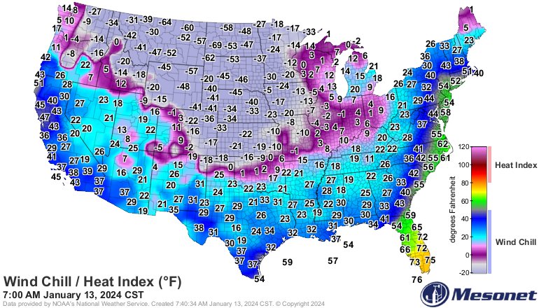
No big deal, just feels almost 150° colder in west ND compared to south FL this morning.
34
271
2K
There's a growing fear that some tipping point has been reached. Not only is the North Atlantic water temperature 4 standard deviations above the 1991-2020 mean, but the Antarctic sea ice coverage is 6.4 standard deviations below the 1991-2020 mean. A bona fide #ClimateEmergency.

Wow, just wow. The planet is breaking. Antarctic sea ice extent is the headline for me this morning. There was actually a net *decrease* in ice extent day over day, and it's mid-winter there, peak freeze season. Extent is now 6.4 standard deviations below the 1991-2020 mean.

72
708
1K
@SenRickScott Umm, the death penalty AFTER the school shooting happens doesn't do anything to stop the school shooting. 🤔.
17
28
1K
It feels about 140°F warmer in Miami FL than it does in Dickinson ND midday Thursday. 🤪🥵🥶

8
195
1K
#Beryl left the African coast as an easterly wave on June 25, became the season's second named storm on June 29, the season's first hurricane on June 30, and the first major hurricane also on June 30. Today it makes its final landfall. Africa to U.S. travel time: 13 days.

8
395
1K
It's 100°F warmer in south Florida than in northern New York this morning. #ItsSoCold #EndlessSummer

64
697
1K

Digging into statistics a little, the global sea surface temperature anomaly on June 10 is 4.47 standard deviations above the mean. What does that mean in English? There's a 1-in-256,000 chance of observing what we're observing. This is beyond extraordinary.

82
421
1K
A spectacular example of an eyewall replacement cycle in #Harvey today. this 8-hour radar loop is mesmorizing. @UMiamiRSMAS
9
516
1K
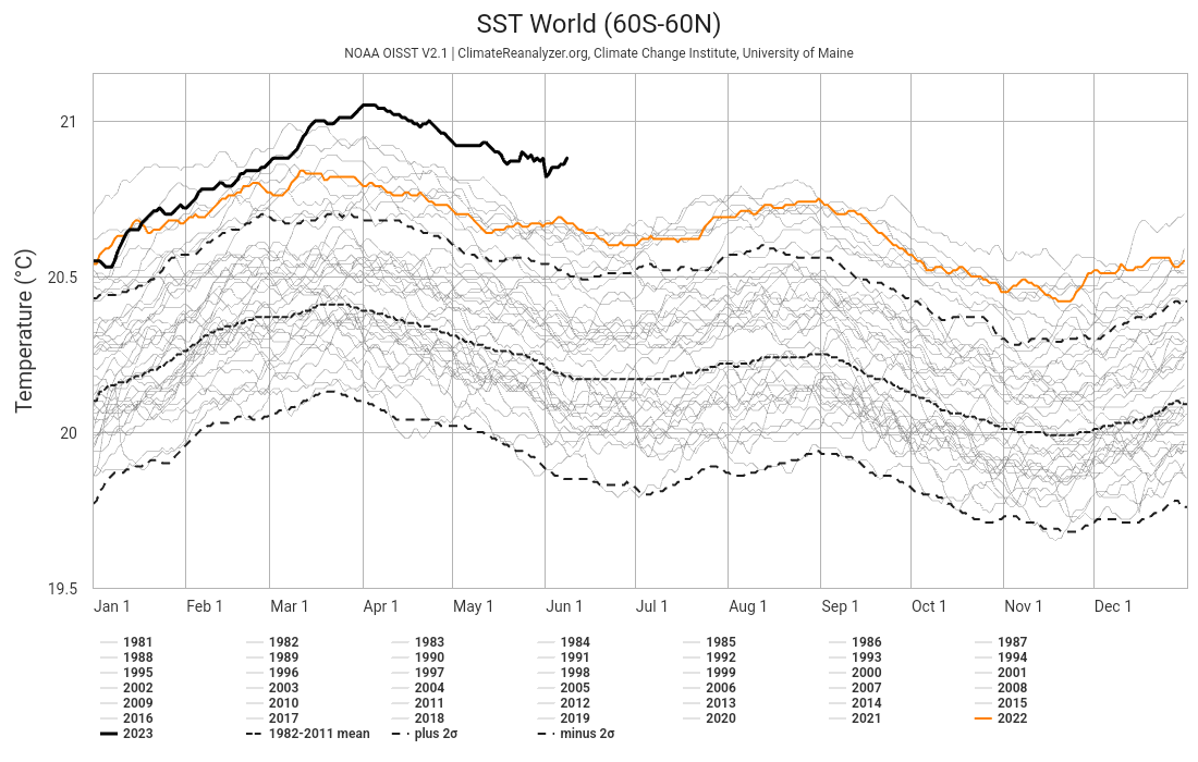
The ocean says it's June 3 in the tropical Atlantic. ⏰.Anomalies this large aren't supposed to happen, and certainly not for 10 consecutive months with no end in sight.

58
446
1K
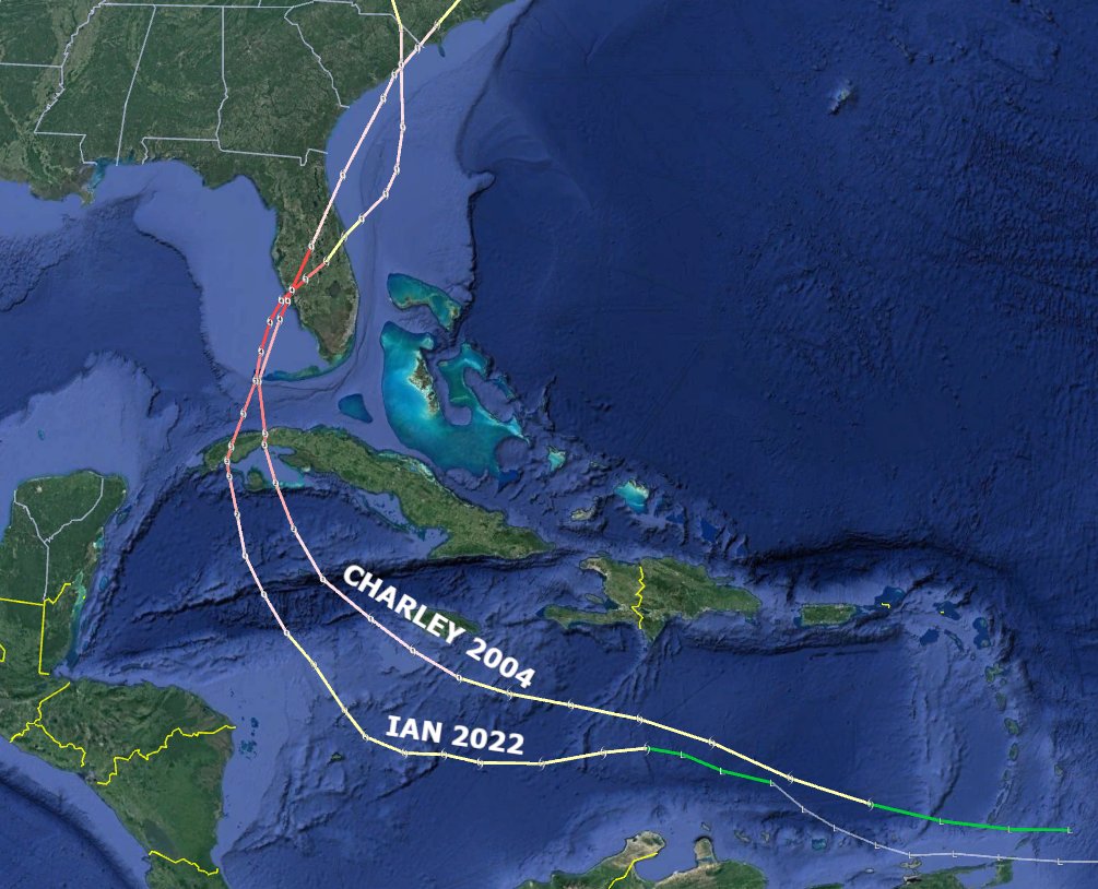
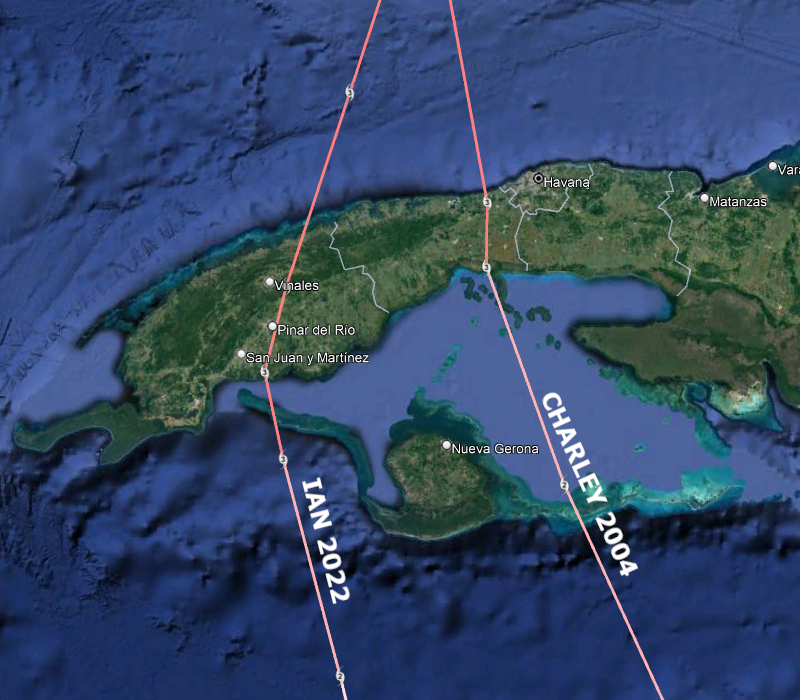
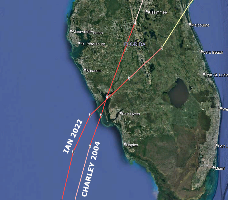
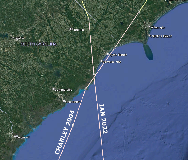
For posterity, the full tracks of #Charley 2004 and #Ian 2022, with zooms on their three landfalls, two of which were at identical locations. Pretty bizarre. Both were Category 3 hurricanes at #Cuba landfall, Cat 4s at #Florida landfall, Cat 1s at #SouthCarolina landfall.
25
305
1K

This is getting to be absurd now. there's not even a close historic precedent for how warm the Atlantic Ocean water is. 🥵📈


61
407
959
@LindseyGrahamSC @PressSec You have got to be kidding. It will be hard to find someone worse, but I trust Trump will succeed at that.
64
43
790

22
158
1K

We're now at 400 consecutive days of record-breaking ocean temperatures in the North Atlantic. 🤯

112
352
905
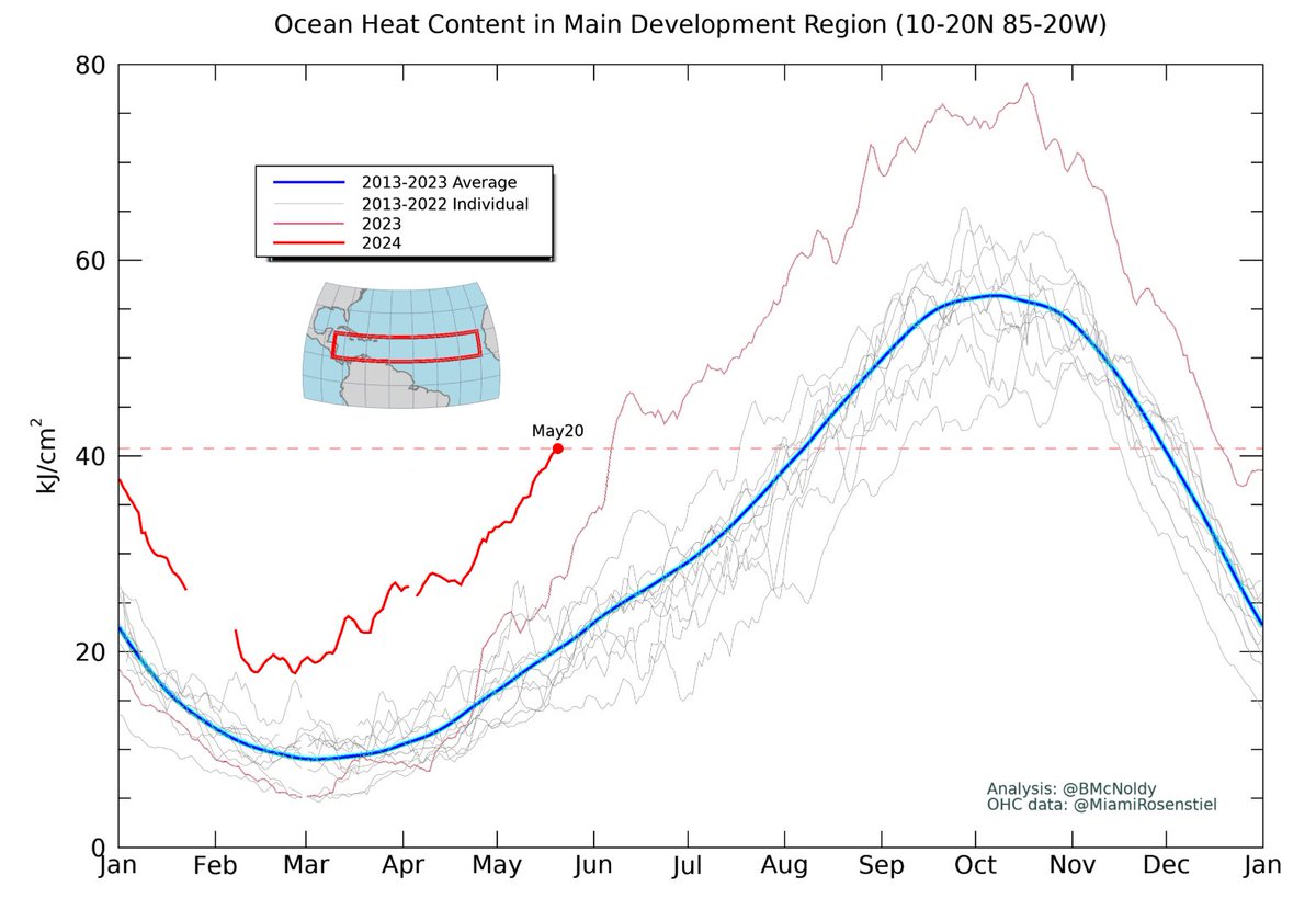
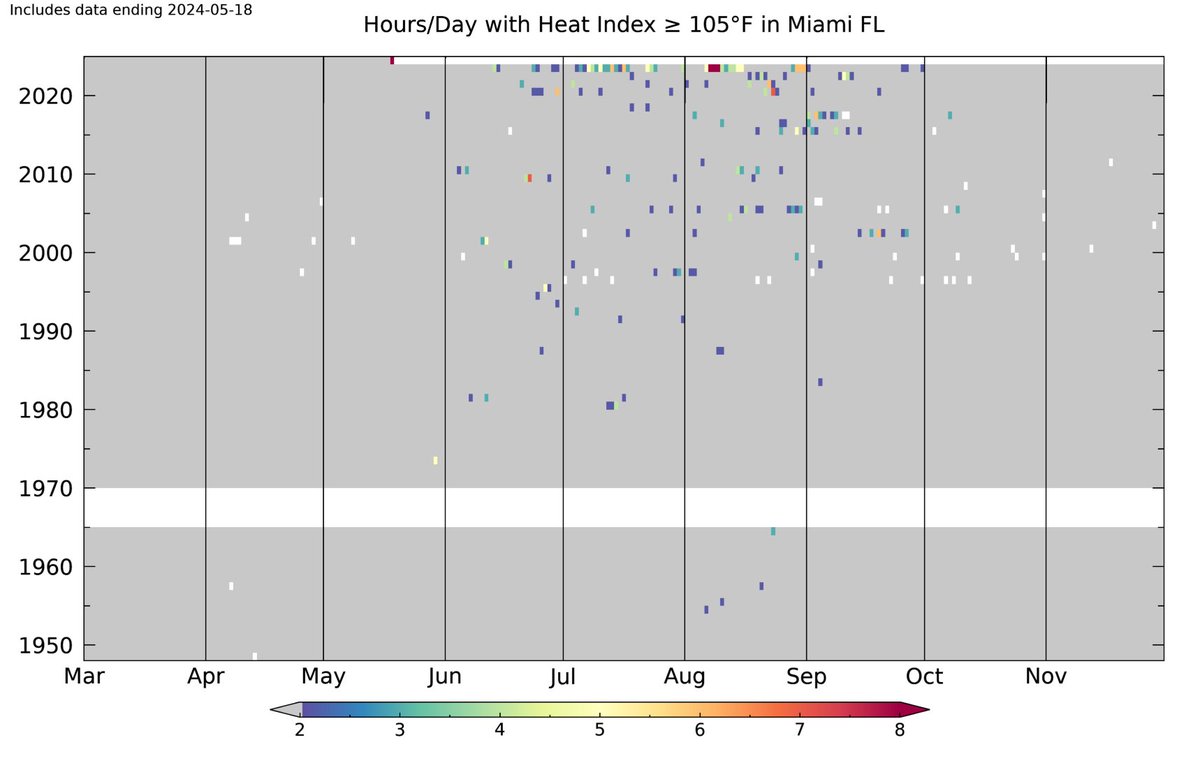
If the 115°F heat index stands at Key West today, that shatters the previous record by an unimaginable 17°F and ties the all-time record high. Oh, and it's only mid-May!.Here is what the updated heat index chart will look like (May 15th circled):.

86
333
921

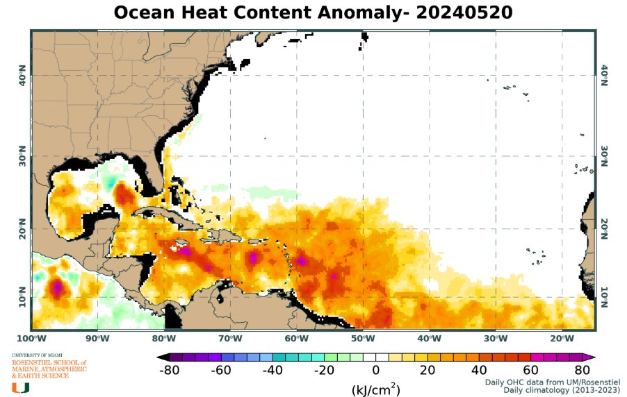
Here's a look at the evolution of sea surface temperature anomalies over the past couple of weeks in the tropical Atlantic. The growing patches of +4°C anomalies are just incredible. Locations northwest of Cabo Verde that would typically be around 24°C now are at about 28°C!
64
322
830
@EricTrump That's funny. Your family has been the source of far greater corruption since before you were even born. It hasn't improved.
11
22
741
The heat index reached 112°F again on Sunday at 3pm in #Miami. In Miami's recorded history, there has been just one other instance of two consecutive 112°+ heat index days: August 8 & 9, 2023. But it's only mid-May! To anyone who was hoping 2023 was a freak anomaly: nope. 🥵

53
313
757
Six years ago today, Category 5 Hurricane Michael made landfall in Mexico Beach, FL. The name was retired and replaced by Milton.
15
77
857
The 112°F heat index at 3pm in #Miami breaks the previous daily record by 11°F and the monthly record by 6°F. It's tied for the 3rd-highest heat index ever recorded in Miami:.114° - Aug 9, 2023.113° - Aug 8, 2023.112° - Jul 3, 2021.112° - May 18, 2024.111° - Jul 22, 2023.
85
331
757
Time to add Ian to the map of recent close calls in southeast Florida.
30
157
815
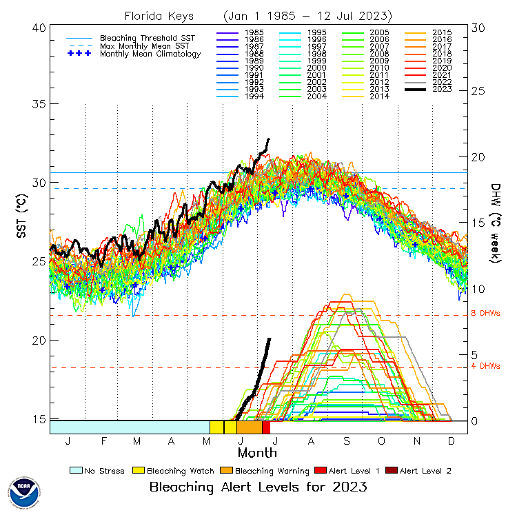
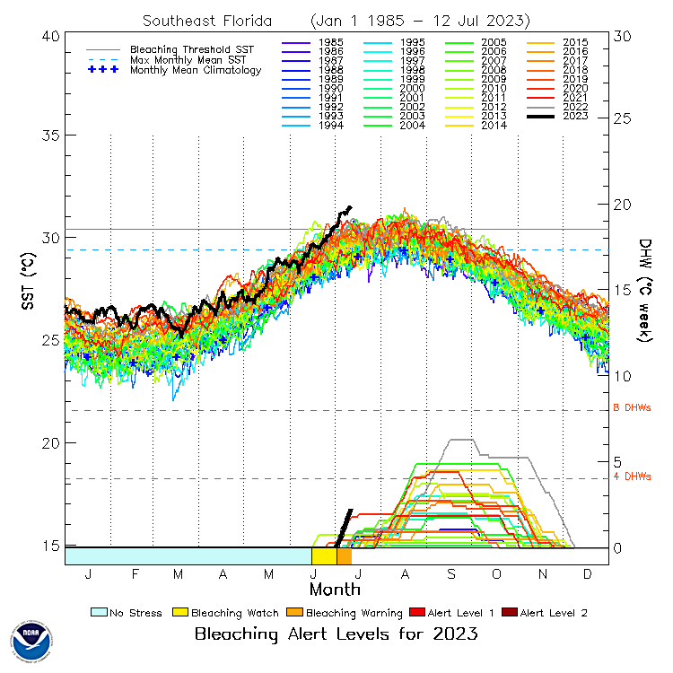
The water temperature in the Florida Keys and southeast Florida is hotter than has ever been measured during any time of year, and it's not even close.
96
353
747
The ocean heat content in the tropical east Atlantic is now *3 MONTHS* ahead of normal. 🤔.

47
326
741
Really happy to finally have the infamous radar loop of #HurricaneAndrew from #Miami in the archive in time for its 30th anniversary. After being tossed from a rooftop onto a parking lot, the WSR-57 radar was replaced by a WSR-88D, which is still there.
32
183
784
The tropical Atlantic water temperature is fast-forwarding by about 2.5 months. the ocean is primed for action, already.


We can squabble over what's behind the rapid Atlantic warming, but it's truly extraordinary to see waters in the Main Development Region of the tropics as warm in June as they typically are the first week of *September*. An undeniably big player this hurricane season.
50
267
728
@LindseyGrahamSC Don't commit crimes in New York. It's pretty straightforward for most of us.
56
32
638

There are a lot of people who have a hard time with the "anomaly" term. Regarding the water temperatures around Florida (and the Gulf), yes they are very warm, and yes they are typically warm this time of year. But they are wayyyyy hotter than normal for this time of year! 🙄


59
183
686

A THIRD pressure anomaly associated with the #TongaVolcano passed through #Miami on Sunday evening. the timing means that it was the first wave making a full trip around the globe! Absolutely mind-blowing power.

7
166
677
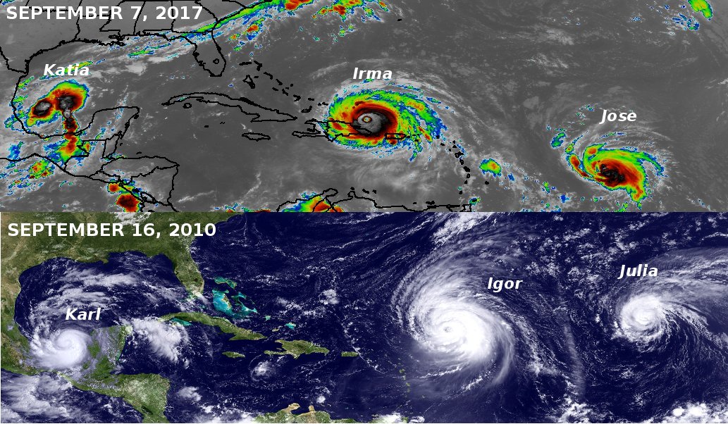
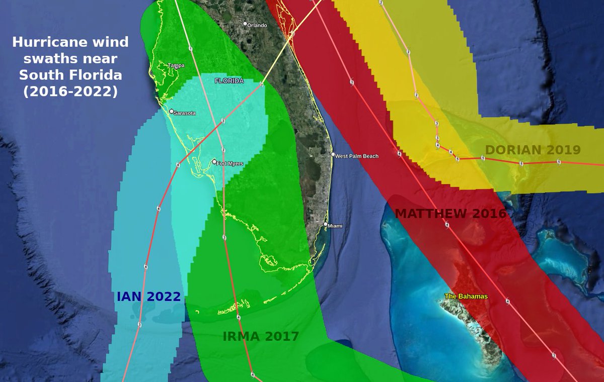
I hope you're not too superstitious, but talk about luck! #Matthew ('16), #Irma ('17), and #Dorian ('19) all passed ominously close to southeast #Florida as Category 4 hurricanes, yet none of them brought sustained hurricane-force winds to the heavily-populated #GoldCoast.

45
306
692
@realDonaldTrump So judges AND polls that disagree with your regime are fake? Are you serious? Sounds an awful lot like a dictator. .
14
50
607
That long-delayed evacuation of a high-risk area seemed troubling and suspicious. and it was. The forecasts were good, but the response to them was botched, with deadly consequences.

We have been investigating the delayed evacuations in Lee County, where Hurricane Ian's death toll is at 16 rising. Gov. DeSantis and local leaders said that officials acted swiftly in response to forecasts. But there is much more to the story…. 1/10.
27
260
552
@realDonaldTrump Wow, you really don't know when to shut up, do you? That's ok, makes it all go a lot smoother for those of us who want our country back. :-).
26
41
559
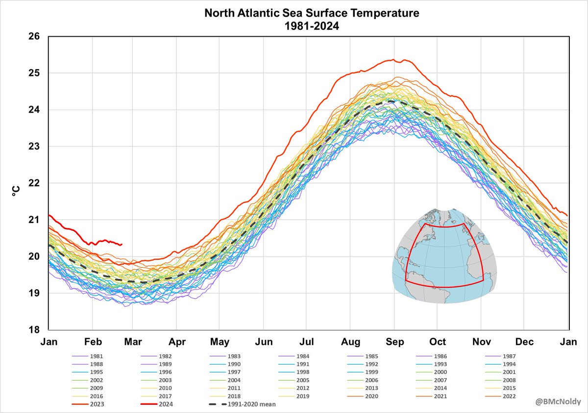
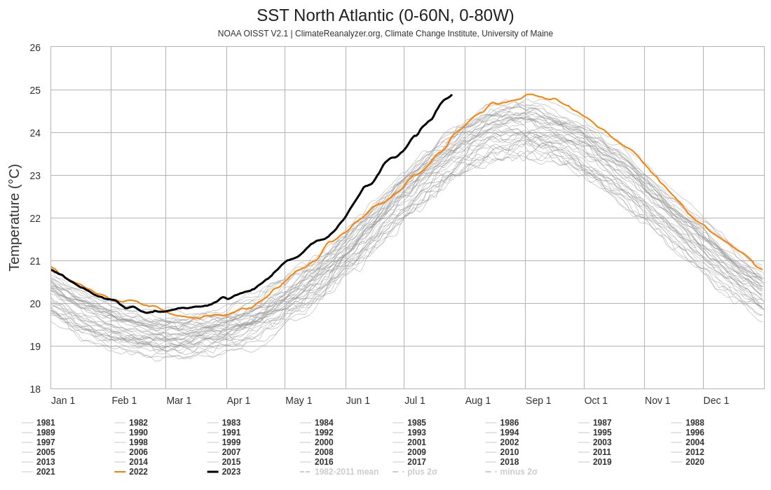
The sea surface temperature averaged over the North Atlantic has now been record-warm for 15 consecutive months. One does start to wonder how or when it stops breaking its own records every month and year. this is not normal.

69
220
570


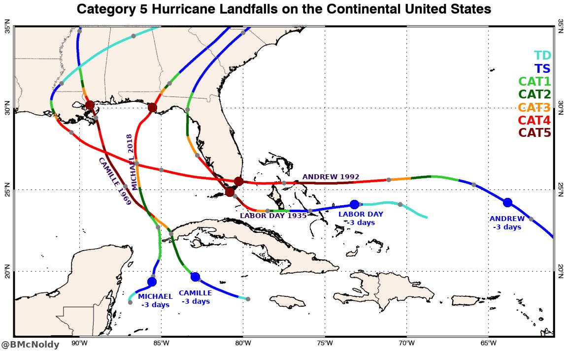
Your annual reminder that crazy things can happen:.All four Category 5 hurricane landfalls on the continental U.S. were from storms that were not even hurricanes just *three* days before making landfall!.It's critical to be vigilant and prepared throughout hurricane season.
24
186
553
April 3 #COVID19 update. it has now been 1 month since the US had its first 100 confirmed cases, and just 7 deaths. As of Friday morning, those numbers are now 246,000 and 6,100. The number of deaths is doubling every 2.7 days. #coronavirus #SARS_COV_2

38
360
524
I am completely flabbergasted by the extent of the anomalous heat throughout the tropical Atlantic. I'm looking forward to joining @DaltonHesley on NPR's @FloridaRoundup today to talk about implications for coral and hurricane season this summer.

38
177
519
This radar loop begins when Hurricane #Beryl made landfall and spans 21 hours. It illustrates the nearly 100 tornado warnings (red polygons) that were issued as the potent rainbands moved inland. and as usual, the vast majority occurred in the storm's front-right quadrant.
7
189
545
Returning to normal while we're still on the uphill climb is like cutting the cords to your parachute when you're halfway to the ground because you're tired of going slow and you're close enough anyway. It doesn't end well. #covid19 #coronavirus

14
196
441
3
145
533
This is getting to be unbelievable, but a sixth pressure anomaly associated with the #TongaVolcano was recorded in #Miami on Tuesday night, timed exactly to be the 2nd global circuit of the second pressure wave (the one traveling the long way between Miami and #Tonga).

16
137
509
Radar loops have been finalized for #Florence, and include a 24-hour loop for landfall and a 104-hour loop to cover its slow trek through #NorthCarolina and #SouthCarolina. Please visit @UMiamiRSMAS
6
339
494
There's been a lot of attention on Atlantic ocean temperatures, which there should be! What we're seeing is absolutely stunning. The "Main Development Region" SST is as warm as it normally would be in mid-August, and in terms of ocean heat content, it looks like early August.


34
173
486
Déjà vu: the water surrounding South Florida has a very high fever again heading into summer.

26
90
483
Tropics check:.On May 20, the ocean heat content in the Main Development Region (MDR) of the Atlantic is now where it normally would be on August 10. 💣.
24
199
490
The first half of June is behind us. hopefully the second half settles back down to "just" record-breaking instead of absurdly record-shattering. 🤷♂️ 🥵 📈
60
97
446
I whipped up a map showing the approximate area of hurricane-force winds at Florida landfall for hurricanes Charley (13Aug04), Wilma (24Oct05), Irma (10Sep17), and Ian (28Sep22). The ~area covered by those winds, in mi², is: .Charley - 970.Wilma - 20,200.Irma - 10,900.Ian - 5,900

18
130
489

20 years ago, on the morning of September 11, 2001, Category 1 Hurricane Erin was located just off the northeast U.S. coast. At 11:15am, NASA's Terra satellite passed over the region and captured this unique and terrible moment in time:

10
136
463
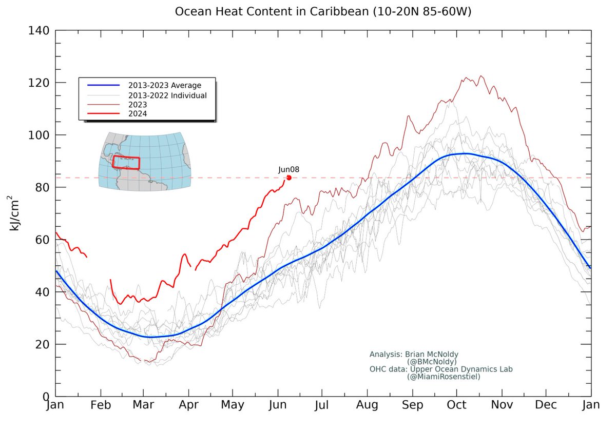
The ocean heat content averaged over the Caribbean Sea is not only a record for the date (again), it's the highest it's been through August 2 (that record was set in 2023). It's as high as the average on September 2. The anomaly just keeps increasing too.
14
203
436
@LindseyGrahamSC Did you see the part on the news about 6 people being killed in the school? Might check up on the headlines before declaring victory. 😒.
4
6
377

This is getting to be utterly unbelievable. the North Atlantic SSTs have just set a new record anomaly on June 20, beating the previous one from June 10. At an average temperature of 23.24°C, that's 1.11°C above the 1991-2020 mean, or +3.87 standard deviations. 1-in-18,650.


29
163
425
Say it with me: the track forecast cone is not an impacts cone.

17
56
441


The average sea surface temperature in the North Atlantic has now reached as hot as its ever been in recorded history. a full month before the climatological peak. Based on the 1991-2020 climatology, the current temperature has 1-in-41,000-year odds of happening (0.0025%).
60
191
373
@realDonaldTrump And you a so-called president. start acting like it. You are not king. Your election needs to be overturned.
15
34
359
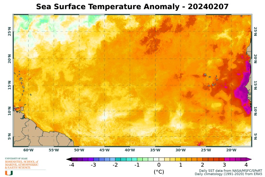
As of February 7, the tropical east Atlantic sea surface temperature is as warm as it would typically be on JUNE 7. The anomaly, averaged over the area shown on this map, is +1.26°C. with areas off the west coast of Africa exceeding +4°C.
15
163
382

The water temperature in much of the #FloridaKeys is 95-97°F on recent afternoons. People are questioning the data or perhaps a bad sensor. I doubt all of the stations are going bad at the same time. The measurements are all taken 1.5 meters (~5 ft) below mean low tide. [1/3]:


25
113
367