
Dr. Alicia M Bentley
@AliciaMBentley
Followers
8,357
Following
4,196
Media
2,493
Statuses
6,572
Atmospheric scientist // Global model evaluator @NWSEMC // Ph.D., M.S., B.S. @UAlbanyDAES // Yoga, NY sports, wine // Restaurant Reviewer // Opinions are mine
Washington, DC
Joined August 2013
Don't wanna be here?
Send us removal request.
Explore trending content on Musk Viewer
#Comebacktome
• 612235 Tweets
#RightPlaceWrongPerson
• 390502 Tweets
RM IS COMING
• 317962 Tweets
namjoon
• 265030 Tweets
#LoseMyBreath
• 231941 Tweets
Official MV
• 144091 Tweets
メイドの日
• 113708 Tweets
Luka
• 83173 Tweets
Celtics
• 79847 Tweets
भगवान परशुराम
• 75804 Tweets
#ดวงใจเทวพรหมSportsDay
• 70197 Tweets
メイドさん
• 50888 Tweets
Megan
• 42184 Tweets
メイド服
• 40010 Tweets
भगवान विष्णु
• 38760 Tweets
ドラマ化
• 30620 Tweets
Mavs
• 29235 Tweets
Rayados
• 22129 Tweets
RTTT
• 18074 Tweets
Sosa
• 17996 Tweets
Tigres
• 17879 Tweets
太陽フレア
• 15286 Tweets
Canales
• 15208 Tweets
Pumas
• 14792 Tweets
Hayırlı Cumalar
• 12197 Tweets
Samir
• 11789 Tweets
Chet
• 11311 Tweets
#AkshayaTritiya
• 11192 Tweets
IS:SUE
• 10193 Tweets


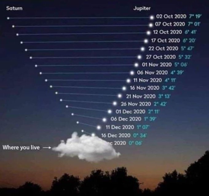
I did not make this plot and I can't find the original source, but I feel it summarizes today quite well. 🤣
#jupitersaturnconjunction
23
113
590
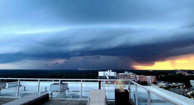
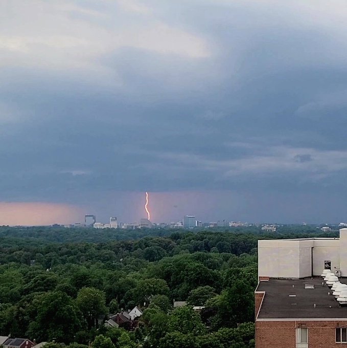
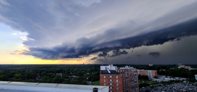
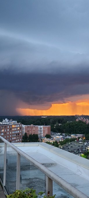
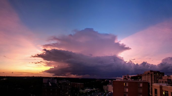
Easily the most impressive sky that I have seen during my time in the DC area! Storm over Bethesda! Incredible!
@capitalweather
15
57
523
I try to stay very "on brand" on Twitter. I post about weather, coding, and my career. But I thought I would take a second to say that I am not a robot. Living alone during this is hard. I am super lonely. And I hope there are better days ahead.
Thanks for coming to my Ted Talk.
41
3
512
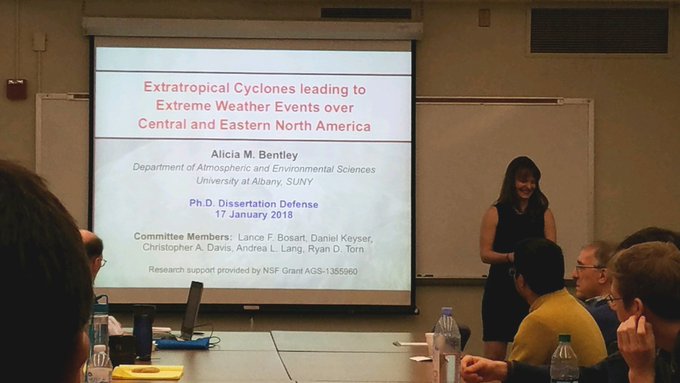
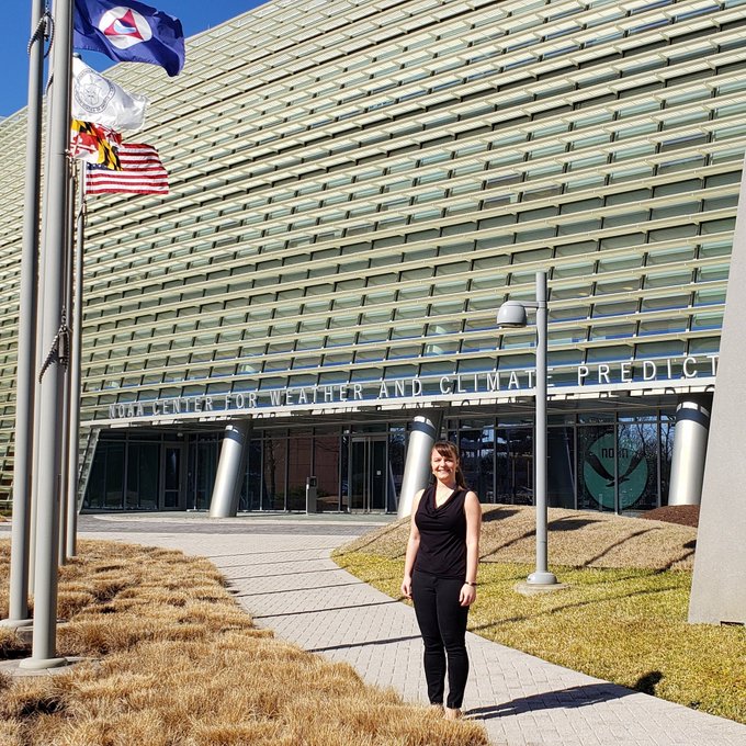
Today, I successfully defended my dissertation and became Dr. Alicia Bentley! In less than two weeks, I'll be moving to Washington, DC, to start my new job at the National Centers for Environmental Prediction! Thank you to my friends and family who helped make this possible!
42
9
490
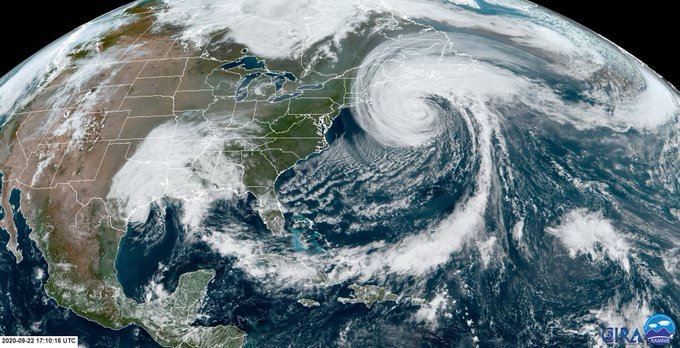
Satellite images like this remind me of why I fell in love with synoptic and dynamic meteorology! Connections everywhere. 🌎
9
36
431
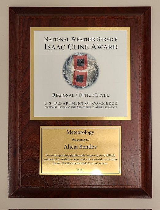
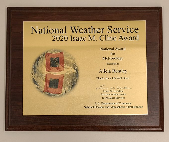
Yesterday, I was lucky enough to be a co-recipient of the 2020 National Isaac M. Cline Award in Meteorology for the evaluation & implementation of GEFSv12. GEFSv12 would never have been possible without my dedicated coworkers at EMC (contractors & Feds). I am incredibly grateful.
30
6
385
Thrilled to share that I've been promoted to "Global Verification Project Lead" at the Environmental Modeling Center! I am extremely grateful for this opportunity. I look forward to planning and leading the verification and evaluation of NCEP's global models in this new role! 🌎

38
2
352

This year didn't go as planned! I got my dream job, but never went into the office! I couldn't go to a gym, but lost 10 lbs at home. I invested in men who didn't invest in me, but raised my standards. I distanced, but never felt closer to friends. Silver linings! Here's to 31! 🎉

45
0
316
A friendly reminder that just because a deterministic model has forecast data out to 384 hours does not mean you should use a deterministic model's forecast data out to 384 hours. Or even past 240 hours. Ensembles can be utilized at longer lead times to assess potential outcomes.
15
32
307
Thrilled to see GEFSv12 become operational during today's 12Z cycle (9/23/20)! Many years of work- what an accomplishment! Here are some useful GEFSv12 links from NOAA/NWS:
Press Release:
Data:
Evaluation:
13
58
296
The atmosphere is a fluid. 🌊

🌊 Vision surréaliste et hypnotisante d’une mer de nuage très agitée capturée depuis le sommet du Plomb du Cantal - Le Lioran.
@cantalauvergne
Credit : Jean-Philippe Bosse
9
380
2K
3
37
287
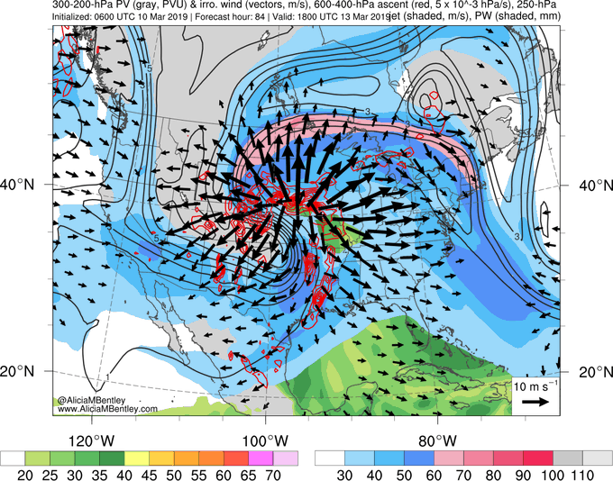
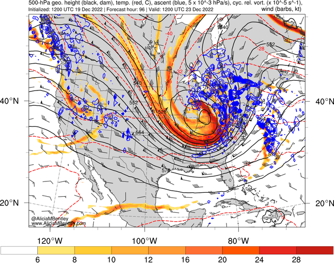
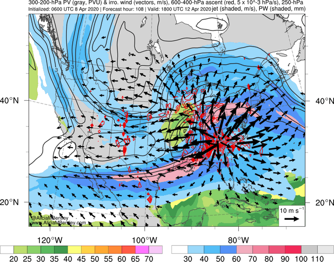
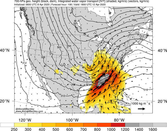
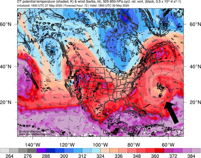
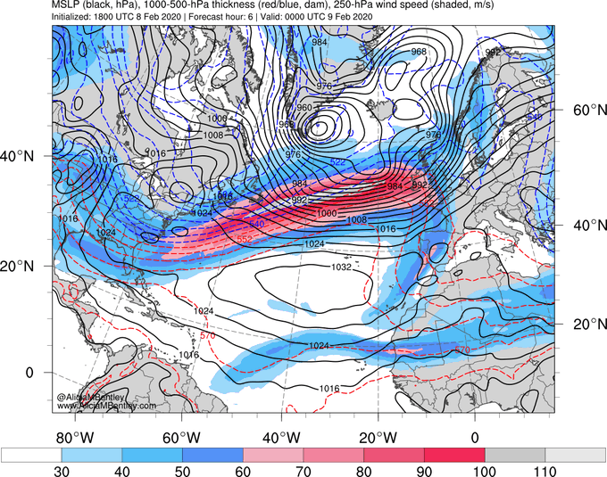
The upcoming central US cyclone is forecast to be assoc. w/ considerable divergent outflow emanating from regions of convection. You can see this in the starburst pattern in the black arrows (divergent outflow) emanating from the red contours (regions of upward vertical motion).
16
74
272
Full disclosure:
1) I was hit by a car tonight.🚘🚶🏻♀️
2) I am totally fine- don't worry!
3) It is very important to look both ways before pulling out into traffic across a sidewalk.
4) If someone rolls up onto the hood of you car, stop to see if they are OK rather than drive away!
67
7
262
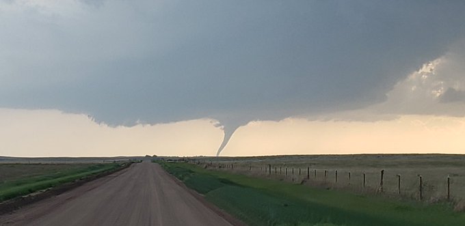
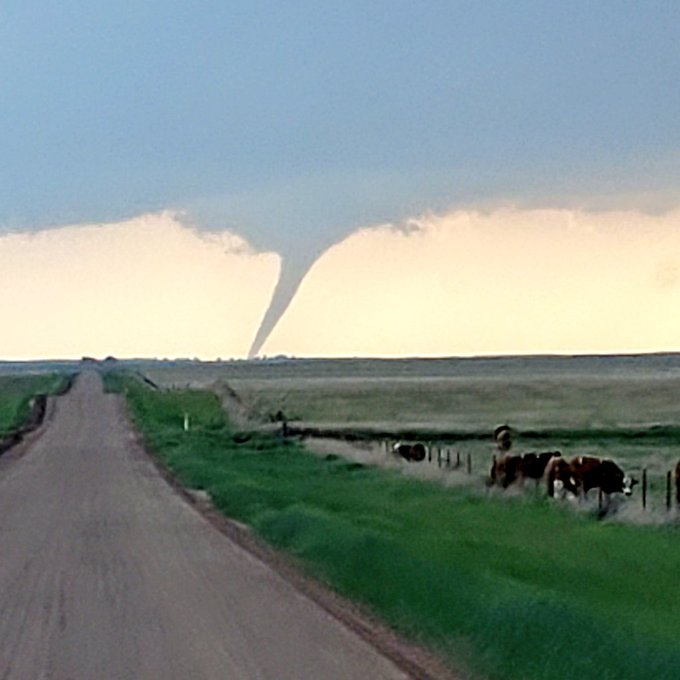
Incredible picturesque tornado southwest of Meade, KS. Empty road, elephant trunk, and rope out. With
@splillo
(7:30pm)
2
41
255
I hate what the upcoming storm is going to do to people's travel plans, but these maps really are beautiful.
4
30
249
My job requires that I disagree w/ people or tell them that they are wrong every day. Despite this, we must maintain a close working relationship. The key to not burning bridges in these situations is humility. Don't act like you're better than them. Superiority gets you nowhere.
3
7
234
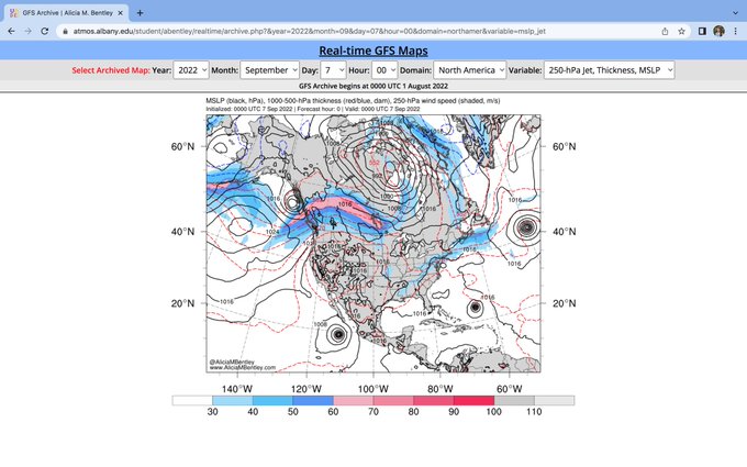
*WEBSITE UPDATE*
I recently added a GFS Analysis Archive to my website! The archive begins on 8/1/22 and will be updated once a day through the present.
I hope this new archive will be useful to students, faculty, forecasters, etc.! You can find it here:
10
37
224
Models are coming into increasing agreement on the potential for a severe weather event across the Southeast on Easter Sunday.
Ingredients include 1) a coupled jet, 2) a cutoff low rejoining midlatitude waveguide, 3) major moisture transport from GoM, 4) anomalous low-level wind.
13
56
223
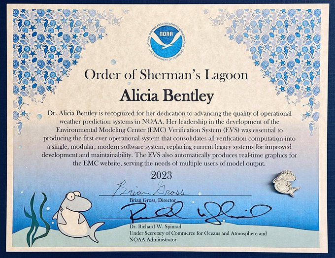
I'm excited to share that I received the NOAA Silver Sherman Award today! 🌎 I did not expect this and am incredibly honored. I hope that the new EMC Verification System (EVS v1.0) helps improve NOAA's operational weather prediction systems for many years to come! 🌐💻
21
4
217
Today at 4:15pm, Lance Bosart will begin teaching the final class of his 100th semester at
@UAlbanyDAES
. The first recipient of the AMS Edward N. Lorenz Teaching Excellence Award, Lance holds a very special place in the hearts of many of his former students. Here's to 50 years!🥂
9
24
215
Animation of accumulated precip (in.) along the West Coast over the next 8 days (GFS init at 12Z 10/20). Precip will fall in multiple rounds, w/ the final round extending the furthest south into CA. Over 12" of precip is currently forecast for portions of the Sierra Nevada.
#CAwx
10
57
211
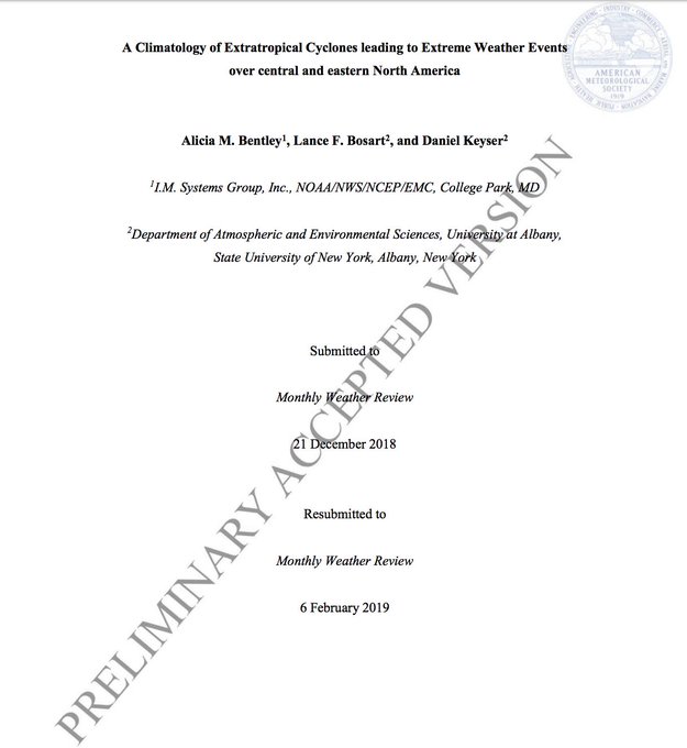
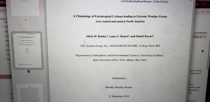
The first paper from my Ph.D. is in final form in Monthly Weather Review! 😀
"A Climatology of Extratropical Cyclones Leading to Extreme Weather Events over Central and Eastern North America"
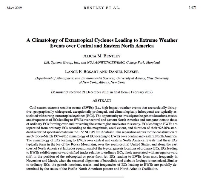
12
11
208
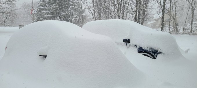
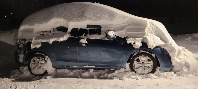
1:33pm update: My car turned on! It also has a fun haircut! 🚗❄
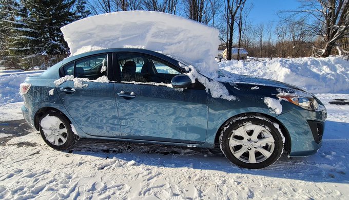
8
8
193
I have the Weather Channel on this morning as I work from home (super nostalgic) and I just had the biggest moment of: "Wow. This is real. I'm a meteorologist too." I've never actually had that realization before. Hit me like a ton of bricks. My 5 year old self would be proud. 😀
8
3
185
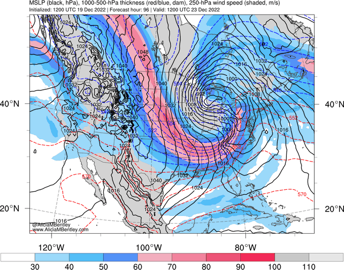
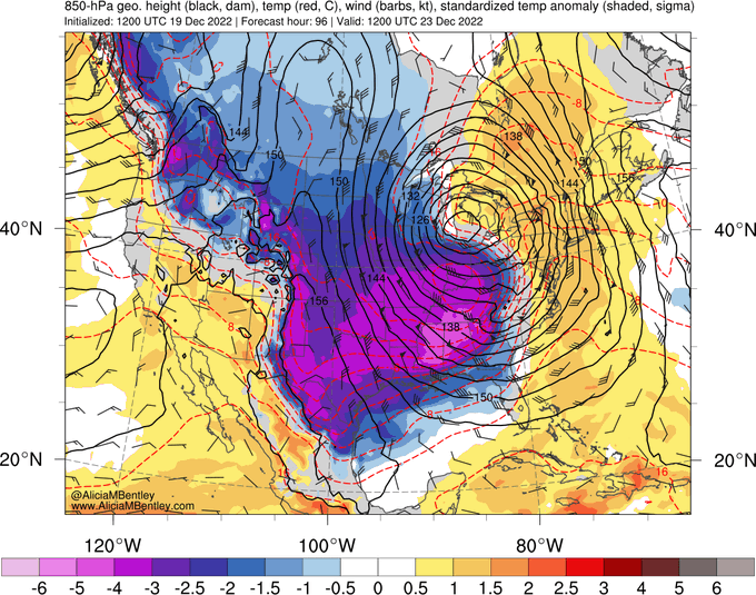
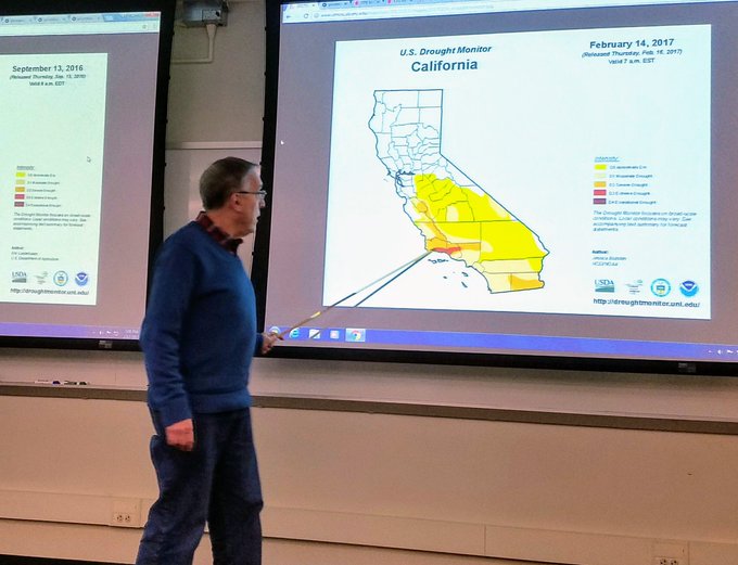
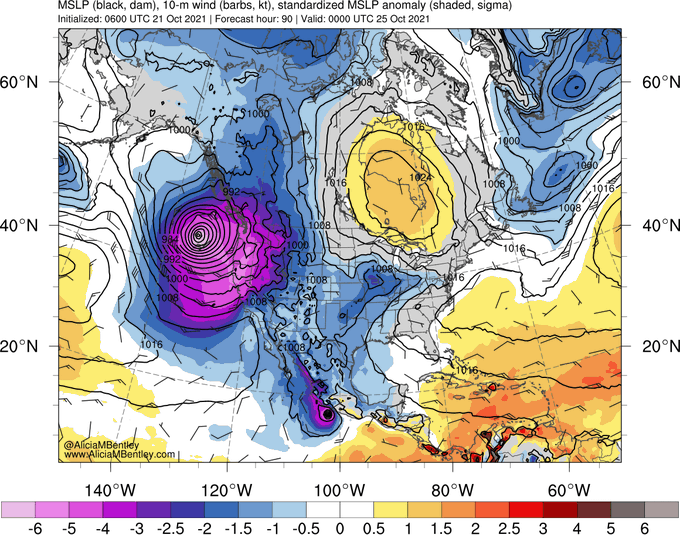
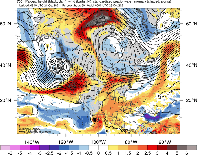
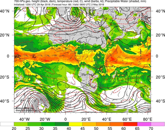
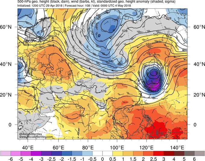
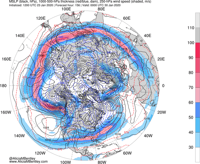
While today's rapidly deepening cyclone off the West Coast is impressive (not shown), Sunday's rapidly deepening cyclone is even more so. GFS forecasts valid 0Z 10/25 reveal <−6σ MSLP anomalies near the cyclone center and >4σ PW anomalies over CA (assoc. w/ needed precip).
#CAwx
5
34
183
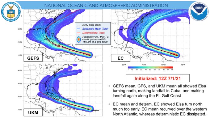
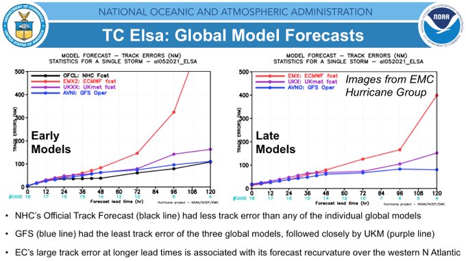
An examination of track forecasts of TC Elsa: GFS forecasts consistently depicted Elsa making landfall along the FL Gulf Coast for ~7 days, whereas early ECMWF forecasts (Day 5-7) depicted recurvature in the western N Atlantic. Mean track error plots highlight these differences.
13
38
182
As fantastic as many of Ted Fujita's scientific discoveries were (e.g., microbursts), I found myself in absolute awe of his artwork. They were "just" graphs and maps and diagrams, but it was art. Truly incredible. We should all aspire to make science that beautiful.
#MrTornadoPBS
9
13
179
I went back to the office today (yay!!!), where I was shocked to receive two NWS Issac Cline Award plaques for the GEFSv12 implementation! My favorite model evaluation so far. Looking forward to evaluating GEFSv13 next year!

11
1
170
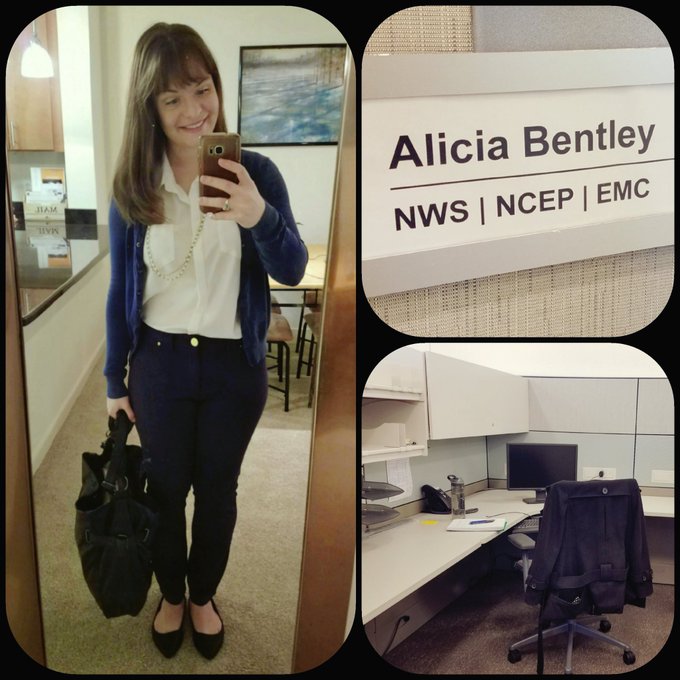
My business cards arrived today! They make my current position feel even more real somehow! 🌎
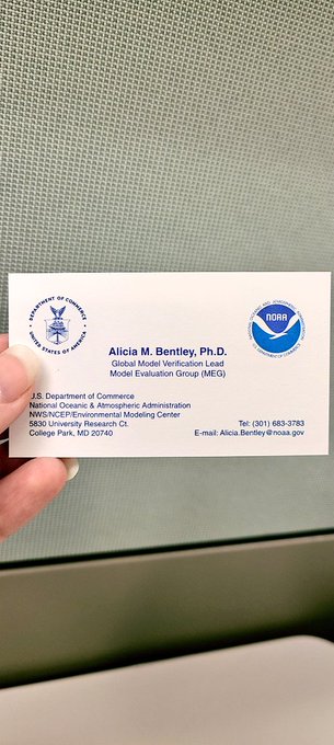
2
0
176
Version 1.0 of the EMC Verification System (EVS) became operational today! Thank you to everyone who made this possible! 🌎🎉
You can view the near real-time verification of operational weather, ocean, and aerosol models here:
More to come in EVS v2.0!
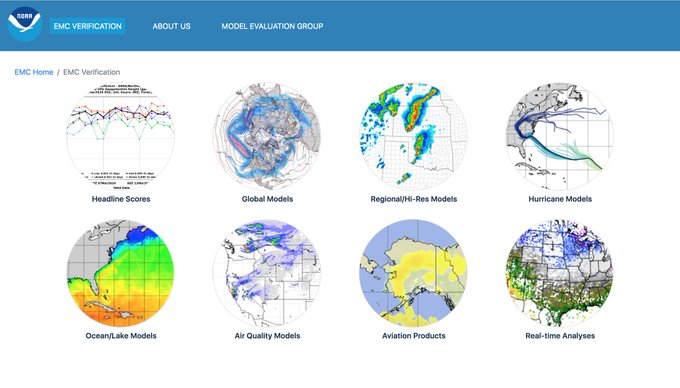
4
28
170
Excited to unveil my new GEFS webpage () and updated GFS webpage! Loops are simpler, cleaner, and easier to use on your laptop *and* your cell phone! Huge thank you to
@burgwx
for helping make my vision of a new image viewer a reality! Enjoy!
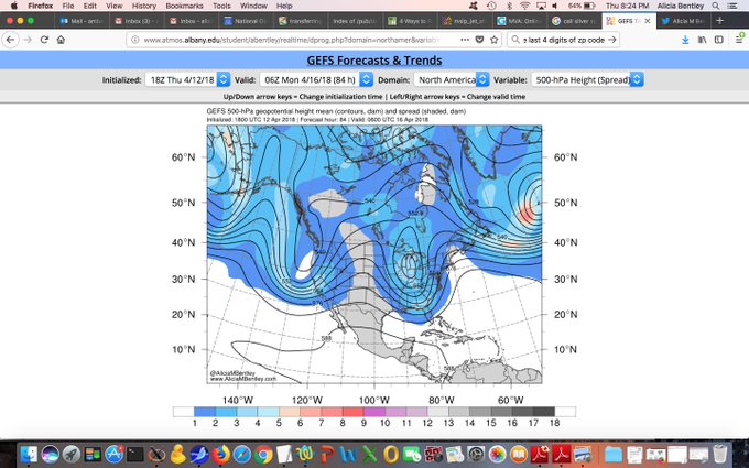
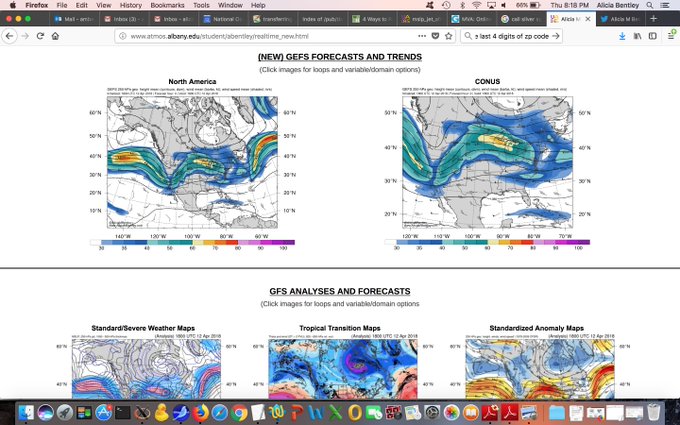
8
23
162
It's official! The GFS transitioned to the FV3GFS (GFSv15.1) today for the 12Z cycle! What a whirlwind my first year at work has been!
2
10
159
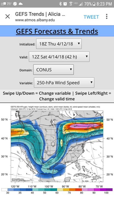
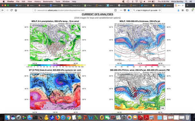
My *entire* real-time GFS webpage has been updated! Existing domains have been modified for cell phone compatibility, and Asian & African domains have been added! Any GFS image I produce can be accessed on your computer or cell phone from this link: Enjoy!
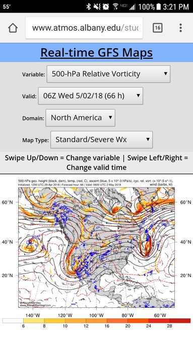
15
22
154
The atmosphere is a fluid. 🫕🌊

This time-lapse from
@cielodecanarias
shows the interaction of the
#VolcanLaPalma
eruptive plume with the Temp inversion at the top of the Saharan Air Layer that forces it to move horizontally at 5300m asl. The volcano emits pulses of different intensity which causes these waves!
75
2K
5K
5
17
152
Celebrating 5 years at EMC by wearing my NWS shirt today! 🌎
8
2
144
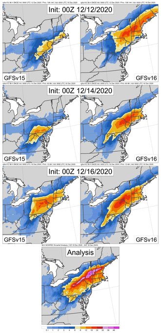
A comparison of GFSv15 and GFSv16 snowfall forecasts of the Dec 2020 Northeast snowstorm reveals that GFSv16 did much better, highlighting the threat for >12" of snow across PA, NY, and New England 1) considerably earlier, 2) more consistently, and 3) more accurately than GFSv15.
3
19
140
*Excellent* example of how a recurving West Pacific typhoon can excite an eastward-dispersing Rossby wave train in the NH.
Typhoon
#Bualoi
has perturbed the midlatitude waveguide, resulting in alternating ridge/trough amplification downstream that extends from Japan to Europe!
6
35
138
1
10
136
The first paper from my Ph.D. ("A Climatology of Extratropical Cyclones leading to Extreme Weather Events over central and eastern North America") is officially in Early Online Release! I've never been prouder of something that I've written. Enjoy!
5
10
137
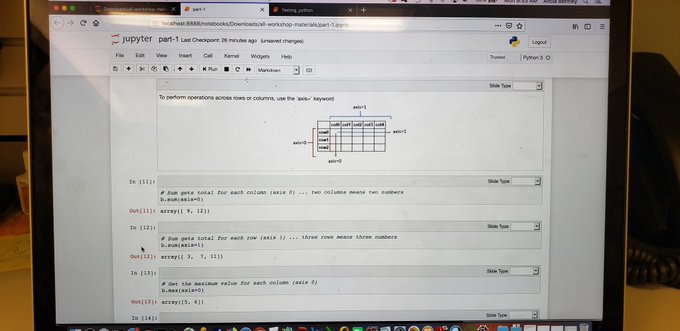
It's a big day! Starting the switch from NCL to Python!
18
4
134
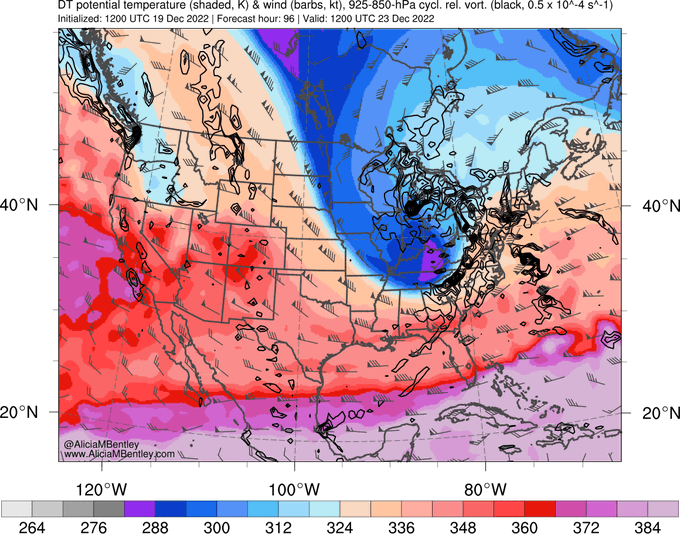
Excellent example of how anomalously cold low-level air moving from the Arctic into the continental U.S. is bounded by the eastern edge of the Rockies. You can almost see the outline of the Rockies by noting the western edge of the blue shading (cold) as it moves south next week.
3
27
131
I have made a life-changing (and very adult) purchase.
16
1
132
1
12
129
Short lightning video taken during last Sunday's flight from Orlando to Dallas, en route to Seattle!
1
32
124
It's pretty difficult to get a <-4σ standardized MSLP anomaly in the North Atlantic during the winter. If this forecast verifies, we could see a 927-hPa cyclone with hurricane-force winds at 1800 UTC on February 15th!
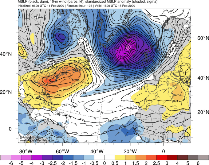
13
31
122
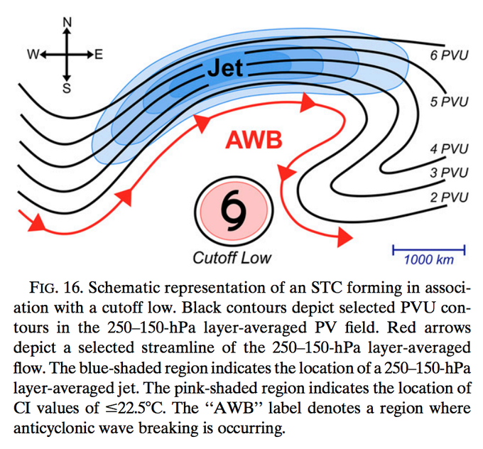
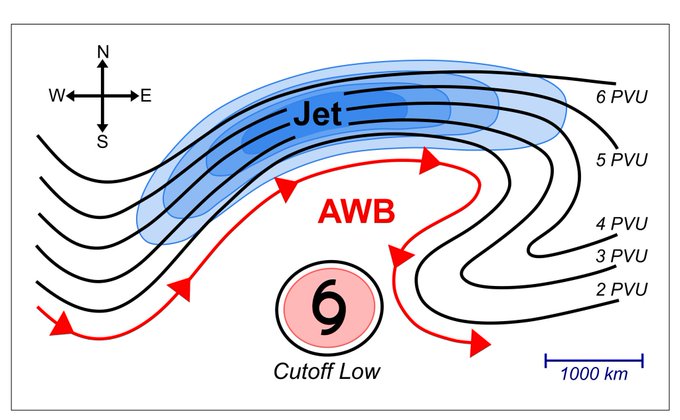
Keeping an eye on another potential STC/TC genesis event in the N Atlantic over the next few days! If a system does develop, it would form in assoc. w/ a cutoff low (a common upper-tropospheric precursor to the formation of STCs that transition into TCs).
4
31
126
I'm incredibly honored to be a recipient of the 2022 NWS Director's Award for helping to create the NCEP Strategic Implementation Plan! I hope that this plan will help further the mission of NCEP (and the NWS) for many years to come. 🌎

Congratulations to
@UAlbany_DAES
three-time alumna Dr. Alicia Bentley (
@AliciaMBentley
) on receiving the 2022
@NWSDirector
's Award for her outstanding service on NCEP's Strategic Implementation Planning Team!
1
1
50
8
1
127
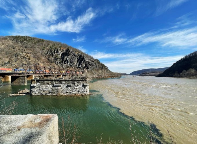
The blue/green Potomac River met a very muddy Shenandoah River in Harpers Ferry, WV, today!
#WVwx
1
6
126
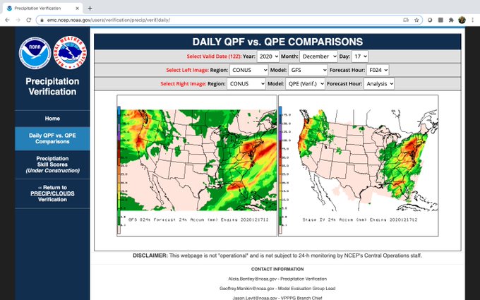
EMC has a new precipitation verification webpage! A great resource to compare past 24-h precip forecasts from global/regional models and CAMs from 2019 to now. Some experimental models too! Plots currently in GEMPAK, but will be upgraded to Python. Enjoy!
4
17
124
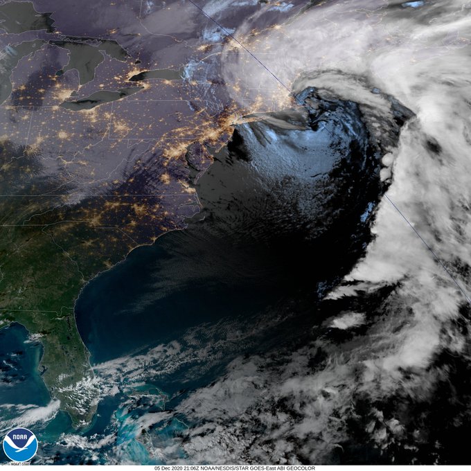
Portrait of a rapidly deepening cyclone at 21:06Z on 12/5/20.
Link:
4
25
119
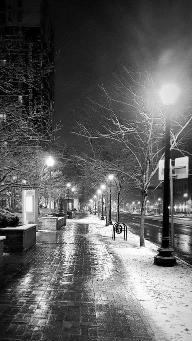
Non-weather tweet: I got my hair done, and I'm in love with it!!! 💇🏼♀️

6
1
122
I started my first job (post-grad school) 1 year ago today! Time has certainly flown. So grateful that I accidentally lucked into a job that ended up being such a great fit (i.e., what I thought the job was is so different from what it actually is). Perhaps it was meant to be?!😉
2
0
121
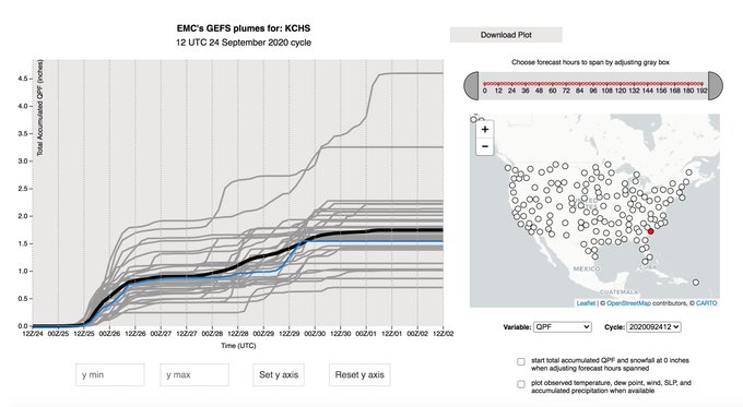
The GEFS plumes webpage now displays GEFSv12!
Updates: An increase from 21 to 31 members!
Black line = ensemble mean
Blue line = GFS forecast
There is a 2-week archive of GEFSv12 forecasts (last two days are missing due to the code transition)! Enjoy!
7
9
120
Take a second to watch this amazing lightning time-lapse from the beginning! Fantastic. ⚡

Storm footage in timelapse Kimberley Western Australia.
Credit 🎥 by Geoff Green
37
386
1K
4
20
117
An incredibly long 250-hPa jet is being forecast over the NH next week! If this forecast verifies, the 250-hPa jet would stretch across over half the planet- from northern Africa, across Asia, the Pacific Ocean, to the west coast of North America! 🌍🌏🌎
9
24
116
5
16
113
Personal Tweet: My former nanny passed away after a long battle w/ complications from covid. She was a strong woman who raised me alongside my parents for the first 10 years of my life. I'm grateful that she knew I got my dream job. Tell the people you love that you love them. ❤
14
2
114
Non-weather post:
I took a 30-minute walk today for the first time in *4 months*! After a partial-thickness tear in my plantar plate, an MCL sprain, IT band syndrome in both knees, and HOURS of physical therapy, I can take a walk again! Health is so precious. PT works miracles!

8
0
116
Non-weather tweet: I'm making a conscious effort to be healthier this summer. Nothing super drastic- just eating better & working out more. I've discovered that eating better makes me feel better in general, which is nice! And I let myself order whatever I want when I go out. 😆

7
2
114
What did we do before GOES-16?🌎

Thunderstorms going up on Cuba.
Spectacular view from above.
33
664
2K
5
18
109

Animation shows MSLP & accumulated precipitation assoc. w/
#Hurricane
#Florence
over the next 192 h (18Z
#FV3GFS
). Over 4 inches of rain is forecast to fall across the majority of NC/VA, with 1 to 2 FEET of rain possible along the NC coast (beneath where Florence stalls).
#flood
6
58
96
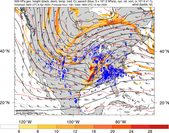
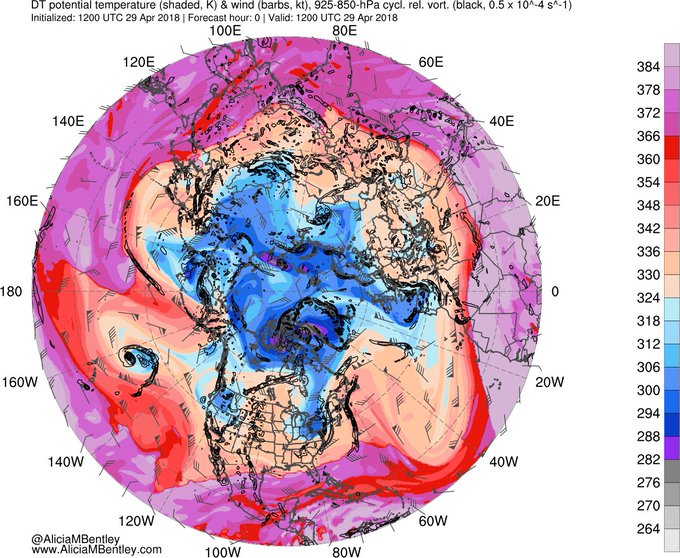
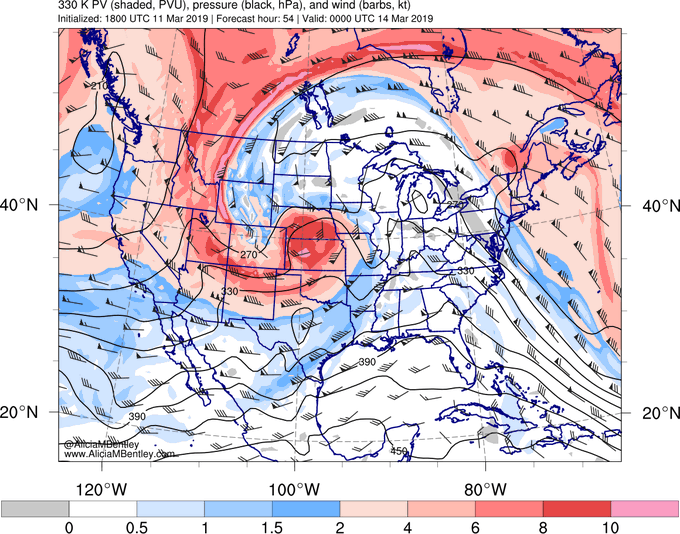
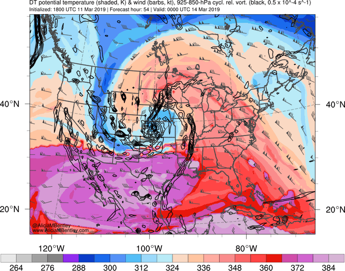
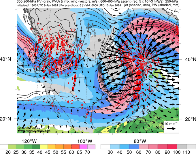
Three different ways to visualize the upper-level "PV hook" associated with the upcoming central U.S. cyclone:
1) Potential vorticity (PV) on the 330K isentropic surface
2) 300-200-hPa layer-averaged PV
3) Potential temperature on the 2-PVU surface (DT)

5
16
109
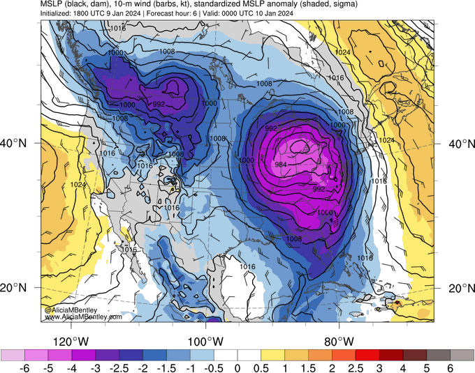
"It's a beaut, Clark! It's a beaut!"
Valid: 0000 UTC 10 Jan 2024
5
9
108
Non-weather tweet: I got my first haircut in a long time this weekend! A great stylist in walking distance? Can't beat it! 💇🏻♀️

0
1
109
Tonight's red eye flights from the U.S. to Europe will experience an impressive tailwind! 🌬✈
7
14
104
ACCEPTED! "Upper-Tropospheric Precursors to the Formation of Subtropical Cyclones that Undergo Tropical Transition in the N. Atlantic Basin"
10
10
106
Spent a full day in the office for the first time since March 12th, 2020! We had great discussions about the future of NCEP! Super motivating. Solid day. 👏🏻
3
0
105
TC
#Hagibis
is forecast to track to the north, tightening the horizontal temperature gradient over the Kamchatka Peninsula and accelerating the subtropical jet. Hagibis will ultimately move to the poleward side of the jet, impacting Alaska as an intense extratropical cyclone.🌀
11
40
101
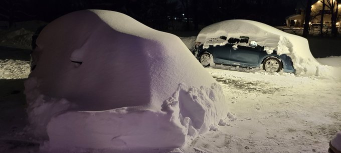
5:27pm update: I found my car! Mom's car is still missing... 😂☃️
1
4
105
Update: My GFS map website is back up and running! 🎊🎉🥳 UAlbany IT fixed the issue yesterday (I'm unsure what it was)!
Thank you to everyone who wrote me over the last 12 days to tell me that my website was down! I appreciate your usage and support! 🌎
5
8
104
Can I just say how excited I am to go back to work on Monday? Is that fair? Super pumped. Here we go.
5
1
105
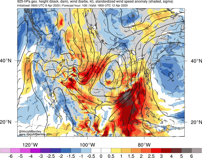
Ongoing convection across the central US is assoc. w/ upper-level divergent outflow. This divergent outflow, which can be represented as the irrotational (not rotating) component of the wind (arrows), will help tighten the upper-level PV gradient and strengthen the 250-hPa jet.
2
20
99