
Quincy Vagell
@stormchaserQ
Followers
18K
Following
18K
Media
8K
Statuses
23K
Meteorologist, storm chaser; photographer. Media inquiries: stormchaserQ @ gmail . com Instagram: stormchaserQ
Moore, OK
Joined April 2013
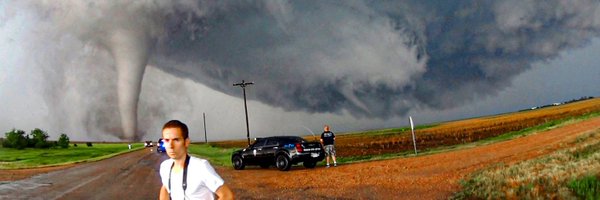
Floyd, NM tornado sequence. Estimated start time was 5:18 p.m. and rope out at 5:40 p.m. Photos captured at 5:21, 5:25, 5:31 and 5:38 p.m. this evening. @NWSAlbuquerque
35
326
2K
I’m offering a $250 reward for the return of stolen equipment, a Sony a7iii and 16-35mm GMII lens. These items, a 10th gen iPad and accessories were stolen in Oklahoma City on Friday. I can supply serial numbers. Email stormchaserQ @ gmail .com or @stormchaserQ on Instagram
3
16
39

Dominating Penn Square Mall and bumped into @ReedTimmerUSA ! Awesome catching up and talking about the Floyd tornado chase
2
2
75
To submit comments on this proposed change, please email https://t.co/KRrhqedNw8 (at)

noaa.gov
U.S. Department of Commerce
Awful idea. The RRFS can't handle low-level cold air masses nearly as well as the NAM. There are also a litany of problems running the FV3 on a convection-allowing grid, some of which are outlined here
2
7
21
Awful idea. The RRFS can't handle low-level cold air masses nearly as well as the NAM. There are also a litany of problems running the FV3 on a convection-allowing grid, some of which are outlined here

It's official! The NAM, HRW & HREF will be completely discontinued, and replaced with the RRFS in early 2026. The RRFS is almost an all-in-one high-resolution forecast system, with multiple high-res 3km members, which will also be a part of the REFS, with a 60hr Ensemble,
12
42
209
Terrible proposal. Has anyone done actual verification with it? The RRFS is so bad that it’s virtually useless for convection. Losing the HREF and SREF would be huge blows to convective forecasting as well. Hopefully they reconsider OR do something to fix the RRFS.
It's official! The NAM, HRW & HREF will be completely discontinued, and replaced with the RRFS in early 2026. The RRFS is almost an all-in-one high-resolution forecast system, with multiple high-res 3km members, which will also be a part of the REFS, with a 60hr Ensemble,
1
3
25
Saw several ground-scraping wall clouds across northern Iowa and southeastern Minnesota today. Each photo is a different storm:
0
2
18
This was one of the most unique vantage points I’ve had of a tornado, in Beltrami Island State Forest last night. I watched this storm produce a few intermittent tornadoes in the secluded woods of northern Minnesota.
5
16
138
Supercell time lapse showing one of the tornadoes NW of Malcolm, MN earlier, toward the end of the clip. #mnwx @NWSGrandForks
1
3
26
Alternate photos of the supercell that produced a few intermittent tornadoes between Grygla and Malcolm, MN. Between 7:21 and 7:34 PM. Found myself on a questionable road, standing on my car roof to see over the treeline. Got a car full of bugs too, but worth it! @NWSGrandForks
5
35
166
Earlier tornado and supercell structure in western Beltrami County, MN. This was at 7:34 pm in the woody marshlands, looking NW from near Malcolm, MN. @mnwx @NWSGrandForks
2
35
208
The (north) eastern target area is trying to thread the needle again, but struggling so far. The northern half of the Tornado Watch is too cool in the boundary layer, while mean 700mb temps across the watch are ~+14C. Going to need more cooling aloft to steepen 0-3km lapse rates.
0
0
10

Zero metering dust devils on the links today at Rio Bravo Golf Course in Bakersfield, CA this morning with desert steep lapse rates abound @NWSLosAngeles @kcalnews
@stormchaserQ @JordanHallWX @aaronjayjack am I doing it right?
1
3
18
Big win for the eastern target chasers yesterday. Many factors/variables can make or break a storm chase. Risk tolerance, timing, logistics, personal biases, model preference, etc. Sometimes you’re right for the right reasons, wrong for the wrong reasons or anything in between.
0
0
12
Tornado-warned supercell thunderstorm near Reva, SD at 6:33 PM / 0033 UTC #sdwx @NWSRapidCity
2
15
106