NWS Los Angeles
@NWSLosAngeles
Followers
144,853
Following
805
Media
14,169
Statuses
39,191
Official Twitter account for the National Weather Service Los Angeles. Details:
Oxnard, CA
Joined June 2012
Don't wanna be here?
Send us removal request.
Explore trending content on Musk Viewer
Amethi
• 151768 Tweets
Knicks
• 141113 Tweets
राहुल गांधी
• 125929 Tweets
Sixers
• 71881 Tweets
Brunson
• 69048 Tweets
Pacers
• 62764 Tweets
憲法記念日
• 62541 Tweets
Embiid
• 57203 Tweets
Philly
• 55693 Tweets
#Raebareli
• 54220 Tweets
Dua Lipa
• 36098 Tweets
Maxey
• 31451 Tweets
Bruins
• 27486 Tweets
FREENBECKY IS OUR HOME
• 27304 Tweets
76ers
• 25525 Tweets
Rony
• 25409 Tweets
連休初日
• 23768 Tweets
#FattuPappu
• 22705 Tweets
Tobias Harris
• 21326 Tweets
Pachuca
• 21125 Tweets
स्मृति ईरानी
• 20137 Tweets
Josh Hart
• 20084 Tweets
ゴジラ-1.0
• 19699 Tweets
पूर्व मुख्यमंत्री
• 19271 Tweets
Smriti Irani
• 18964 Tweets
Hield
• 16949 Tweets
Hayırlı Cumalar
• 16903 Tweets
Pumas
• 15360 Tweets
チャレンジクルー
• 15174 Tweets
किशोरी लाल शर्मा
• 14981 Tweets
KerenTIMNASKU STYdanERICK
• 12445 Tweets
TetapSMANGAT GarudaMUDAKU
• 12067 Tweets
Wayanad
• 11775 Tweets


Pinned Tweet

Our office is excited to be a part of the new initiative to offer weather info in more languages! ⛈️🌈🌤️
Visit for translations of
@NWSLosAngeles
forecasts into
#Spanish
using an AI language model.🗨️
For more info:

15
29
196
For Culver City, the daily observation grabs the at observation temperature from the previous day. Thus, the high temperatures could be reported as in the 80s and 90s, although the day only experienced temperatures in the 70s. Is this a better explanation? (7/7)
1
1
78

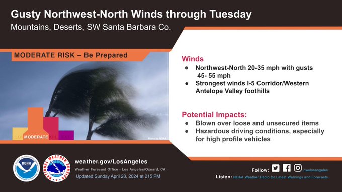


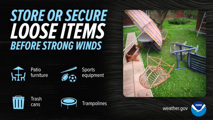
Strong to gale force winds and dangerous choppy seas will affect all coastal waters through the weekend
#CAwx

0
22
60

Do you live in the
#AntelopeValley
? Don't have plans tonight? Come join us at 7:30pm at the VFW Post 3000 in Quartz Hill and learn how to become a weather spotter. Training will be provided. Thanks to the Antelope Valley Amateur Radio Club for hosting this event.
#Skywarn
#CAwx

5
9
52


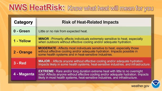
Cool weather is expected this week, but a good resource as we head towards Summer!

Newly expanded NWS HeatRisk combines weather, climate & CDC data to identify potentially dangerous heat that may lead to increased risk for health impacts. To see the current HeatRisk in your area, visit the interactive HeatRisk viewer:
8
161
387
1
13
65
NWS Los Angeles Retweeted
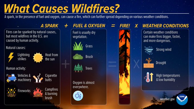
Wildfires are caused by a spark in the presence of fuel and oxygen. Strong winds, high temperatures, low humidity and drought conditions can further impact the fire’s spread. To stay
#WeatherReady
and protect yourself from wildfires, visit
2
61
139
The large earthquake off of Taiwan will NOT produce a tsunami over California. Again, NO tsunami threat exists for California.
#cawx

Tsunami Info Stmt: M6.6 Taiwan 1127 PDT Apr 22:
Tsunami NOT expected; CA,OR,WA,BC,and AK
8
103
270
4
53
263
Today could be the first 90° degree of 2024 in the
#AntelopeValley
. The forecast calls for
#Palmdale
to hit 90° today, then cool to well below normal by the end of the week.
#CAwx
(Photo: Pamela Heckel)

4
35
115