
Robin Wilson
@sciremotesense
Followers
1K
Following
4K
Media
162
Statuses
3K
@[email protected] Freelancer in Remote Sensing, GIS, Data Science and Python. Open-source maintainer. Teacher. PhD in remote sensing of air quality
Southampton, England
Joined September 2012
I've officially launched my freelance business today! If you need any work doing in #remotesensing, #gis, #datascience or #python from a PhD-qualified expert in the field then have a look at my new website ( and get in touch! #freelance #newbusiness.
rtwilson.com
Dr Robin Wilson is a freelancer in Remote Sensing, GIS, Data Science and Python
1
8
24
RT @AstroAdamH: 🚨 Only 2 weeks to go! 🚨. Join the @PyDataSoton workshop on Nov 26 for a practical session learning about #Prefect data pipe….

meetup.com
**Venue**: Carnival House, 100 Harbour Parade, Southampton, SO15 1ST **📢 Want to speak 📢: [submit your talk proposal](https://bit.ly/pydataSoton-talks)** **Please note**
0
2
0
Join Rebalance Earth's GeoTAM Challenge Hackathon!. This open-source hackathon aims to create methods for estimating business turnover at specific locations in the UK. With prizes of up to £2000. 20th-26th Nov, online. See #hackathon #opensource #climate.
0
0
1
RT @mapserving: Happy 26th birthday to GDAL ! From the first commit on 1998-10-17 from a small rural town outside of Ottawa Canada, to almo….
0
127
0
These are excellent books if you like board games (and even if you don't). Very excited about getting my copy in the post tomorrow!.

❤ Looking for a festive romance? .🎄Christmas at the Board Game Cafe is out tomorrow. 🎲Order your copy 🎁 Win a signed copy - comment and retweet this post. 🔍Find me on Insta and TikTok for extra entries. 💌UK only. Closes 12/10/24. #christmasromance

0
2
3
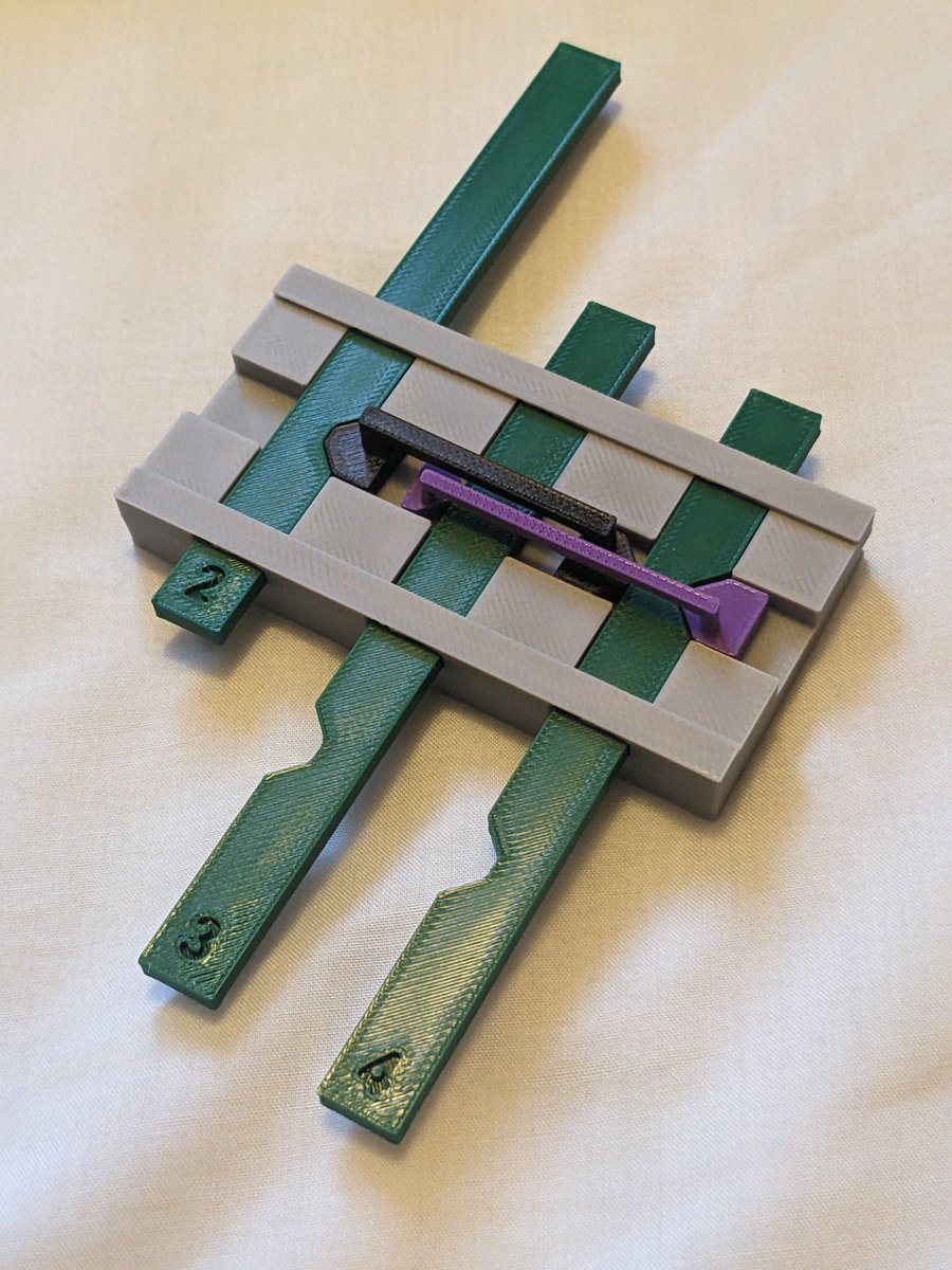
More 3D printing stuff! I've made a model I'm quite proud of, showing how a mechanical signalbox interlocking works (the Victorian-era mechanical 'computer' that stops you setting conflicting routes etc). See #railways #signalling #3DPrinting
0
0
2
RT @bcsmaps: Congratuations to our @ordnancesurvey OS Award Winner: British Placename Mapper, by Robin Wilson. Full map available here: htt….
0
4
0
RT @bcsmaps: Congratuations to our Avenza Award runner up: British Placename Mapper, by Robin Wilson. Full map available here: https://t.co….
0
1
0
Very pleased to win two awards (Highly Commended for the @Avenza award for Electronic Mapping and First Prize for the @OrdnanceSurvey award) at the @bcsmaps annual conference for my British Placename Mapper - see to have a play!

3
2
18
RT @PyDataSoton: We are hosting the 9th PyData Southampton meetup two weeks tomorrow! Register now to guarantee your spot and avoid disappo….

meetup.com
**Venue**: Carnival House, 100 Harbour Parade, Southampton, SO15 1ST **📢 Want to speak 📢: [submit your talk proposal](https://bit.ly/pydataSoton-talks)** **Main Talks**
0
2
0
Looks awesome!.

Testing some new functionality for Lonboard's next release: support for local rasterio images!
0
0
0
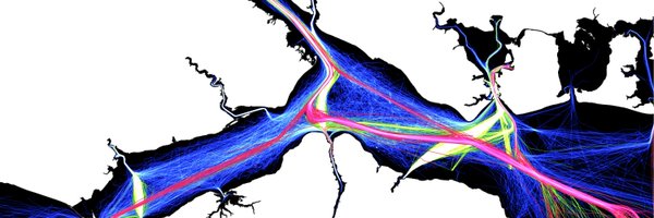
Reading an Environment Agency document as part of my work, and came across this picture from @WoodinRivers's blog - nice to see a link back to my PhD colleagues at Soton. There are also citations to papers from various staff at Soton too.

0
0
1
RT @AstroAdamH: 🚀 Excited for PyData Southampton's 8th Meetup on July 16th at 7 PM! Join us for talks on #Kafka with #Python, @Google #Gemi….

meetup.com
**Venue**: Carnival House, 100 Harbour Parade, Southampton, SO15 1ST **📢 Want to speak 📢: [submit your talk proposal](https://bit.ly/pydataSoton-talks)** **Please note**
0
1
0
I'm giving a lightning talk on Freelancing at @PyDataSoton on 16th June - please come along. See for details. #python #data #southampton.
meetup.com
**Venue**: Carnival House, 100 Harbour Parade, Southampton, SO15 1ST **📢 Want to speak 📢: [submit your talk proposal](https://bit.ly/pydataSoton-talks)** **Please note**
0
1
2
New blog post: a load of links - A load of links I've been meaning to post for ages. Quite a high #geospatial focus, but also some broader ones. Have a look, you might find something interesting!. #programming #python #gis #remotesensing.
0
0
2
New blog post: Accessing Planetary Computer STAC files in @duckdb - see I struggled a bit with authentication and had to use some extra libraries, but got it working :). #geospatial #python #duckdb #PlanetaryComputer.
0
3
12
Introducing a new Python package: offline_folium, which lets you use folium (a Python webmap package) without an internet connection. Check out my blog post at for details. #gis #python #geospatial #webmap.
0
0
0