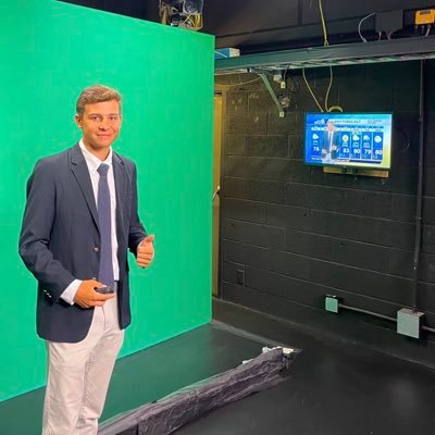
Ryan Kane
@ryankanerWX
Followers
3K
Following
29K
Media
2K
Statuses
9K
Meteorologist @Norcastweather || Terps Atmospheric Science Degree 🐢 || East Coast & MD Weather Updates || Golfer || Summer '23 Intern @wbaltv11
Joined January 2016

A sign Lamar Jackson is ready to return as QB1.

Harbaugh said Lamar Jackson was a full participant at practice today and “we’ll see where it’s at going forward.”
61
95
2K

Lamar Jackson had a FULL practice today ahead of Sundays matchup vs Bears. He should be good to go.
46
130
2K
Trend continues as Euro AI guidance continues to show a near capture by our upper level low... will track this over the next couple days #EcWx
1
9
74
An uncomfortably large percentage of the GENC Google Deep Mind ensembles now landfall Melissa somewhere between the upper Mid Atlantic and Nova Scotia late next week.
22
39
343
Negatively tilted shortwave likely causes a LP system to develop during the day Tuesday causing widespread rain for Mid-Atlantic. Strong CAD feature will result in a raw, chilly wet day with a >1030 HP over S Canada. Would be a mid-atlantic special in January... winter preview?!
2
2
44
Gotta be honest... bit of a concerning trend. Northeast needs to closely watch how Melissa & our longwave trough interact. There is a scenario where Melissa phases with our ULL & pushes into the northeast, similar to Sandy in 2012. Euro AI ain't far off. #EcWx
9
12
147

Wednesday Weather Update: - Cooler conditions begin today under ULL, resulting in below avg high temps & a west/northwest flow - Skies remain mostly sunny into Saturday - Clouds increase Sunday into early next week - Potential exists for low pressure system middle of next week
0
2
15
Showers are beginning to develop over the Blue Ridge & will become much more developed by 8pm. Expect shower activity to push into DC/Balt from 8pm-midnight as the cold front swings through. Cooler & breezy tomorrow behind the front. #MdWx
2
0
15
KaneCast: Tuesday October 21st (1) Chilly, damp start to the day (2) Highs warm into the upper 60s/low 70s (3) Sunny skies with increasing clouds late this afternoon/evening (4) Cold front brings showers 7pm-midnight (5) Rainfall amounts light in the 0.05-0.2" range #MdWx
0
1
15
Upcoming Pattern: My thoughts (1) Upper level low with below avg temps across east CONUS this week (showers associated with ULL) (2) Warmer to start next week as pacific air flows into CONUS (3) Blocking develops late month with ULL around Halloween (lacks good cold air source)
3
9
67
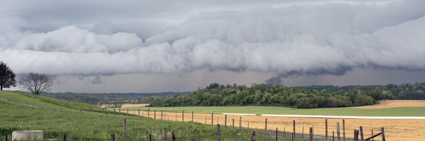
Here comes the cold front associated with a squall line… will pass through DC/Baltimore from 9-11pm #MdWx
0
2
19
KaneCast: Sunday October 19th (1) Partly cloudy skies & very warm(highs in mid 70s) (2) Gusty southerly winds today(25-30 mph gusts) (3) Strong cold front works through this evening (temps drop) (4) Squall line: 9pm-12am, additional showers until 2am (5) Rainfall: ~0.2-0.4" #MdWx
1
0
15
KaneCast: Friday October 17th (1) Very sunny with highs in low 60s today (2) Warming conditions into Sunday as flow shifts out of the south (70s Sunday!) (3) Sharp trough brings showers/storms Sunday evening & overnight (~0.2-0.5" of rain) (4) Windy & cooler on Monday #MdWx
0
0
5
KaneCast: Thursday October 16th (1) Sunny skies under high pressure (2) Chilly, northerly flow out of Canada bringing in cooler air (10-20mph, gusts to 25) (3) Highs in low 60s across DC/Balt (cooler north, warmer south) (4) Patchy frost possible tonight (same areas as last week)
0
0
11
KaneCast: Tuesday October 14th (1) Coastal system slides east today (2) Skies clearing throughout the day, current satellite showers partly-mostly cloudy in between two areas of dense cloud cover (3) Highs in the 68-72 degree range (4) Winds out of north 10-15 w/ gusts to 20
0
0
8

Showers continue to push into the area from the east/northeast this afternoon. Expect this to continue past sunset. Very nasty day with wind driven showers & temps remaining in the upper 50s. Stay safe & dry! #MdWx
0
0
4
KaneCast: A sfc low ~1006MB is located just off the coast of Ocean City MD this morning. This will push showers inland for much of MD, including DC & Balt later this morning into the afternoon. Chilly N/NE flow keeps temps in the upper 50s. Much wetter day than yesterday. #MdWx
1
1
21
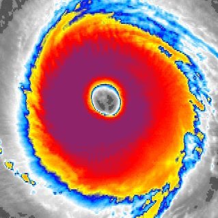
She ain’t the prettiest storm… lots of strung out vorticity will do that

Not a typical storm by any means yet something to track. Apologies as I have been jammed up with work and life thus no time to track.
0
0
3