
Bernie Jenny
@mappingbernie
Followers
929
Following
722
Media
33
Statuses
196
Maps and immersive visualisation at Monash University, Melbourne
Melbourne, Australia
Joined March 2018
Eduard update 1.4.15 can replace void values with smooth feathering, export grids to small 16-bit GeoTIFF files with decimeter precision, and includes various improvements and bug fixes. https://t.co/JZuWPG34BX

eduard.earth
Eduard for Mac, the tool for creating beautiful shaded relief images for maps.
0
4
36
#NACIS special: To celebrate the launch of Eduard Cloud, new accounts get two free Eduard credits. Happy map making!
0
4
27
We are thrilled to introduce Eduard Cloud at https://t.co/GgLj0nHICi High-quality shaded relief for terrain maps can now be created on Windows, macOS, and Linux with any modern browser.
3
36
298


For my southern hemisphere friends: a south-at-top version of Equal Earth. The map even has an albatross on it. Get it here for free: https://t.co/PnpgUI8dlV
0
1
2
Mercator projection be gone: Africans in support of the Equal Earth projection. https://t.co/D4BJde0WNO

aljazeera.com
Common projections shrink the size of Africa, but experts have long debated whether creating a precise map is possible.
2
14
84
Eduard 1.4.13 can now download the great new Global Ensemble Digital Terrain Model #GEDTM30 at various resolutions. https://t.co/JZuWPG34BX
1
16
131

For beautiful and useful cartographic artifacts check out https://t.co/tZujpfAWCQ , @MtnMapper and @mappingbernie preserved (and georeferenced!) airbrush/graphite terrain illustrations by artists of the 70s and 80s. Many of the originals were ~3x2 ft. Here are a few by Ellen
0
4
19
Eduard 1.4.12 released: bug fixes and improvements, including a test to make sure elevation model downloads are not too large. https://t.co/JZuWPG34BX
3
30
226
📣A new version of #ProjectionWizard v2.1 🗺️🌐🪄 is now live as of this morning. Visit https://t.co/d1cm80oNt1
#mapprojection #mapprojections #webMercator #endMercator #mapprojectionsarehard #projectionsarehard #gischat #geospatial
1
13
60
Eduard 1.4.9 can now download Copernicus surface and GEBCO bathymetry models. https://t.co/JZuWPG34BX
1
3
62
A snippet of the new Grand Teton National Park map by @BeccaHoldhusen featuring @EduardShading. GRTE-Becca.jpg
1
5
59
Eduard 1.4.7 adds image masks, improves aerial perspective, and includes bug fixes and improvements. https://t.co/JZuWPG34BX
eduard.earth
Eduard for Mac, the tool for creating beautiful shaded relief images for maps.
0
3
13
Easy Swiss-style relief with Eduard by Jess Zimmerman https://t.co/g06Jhyd0pN via @YouTube
0
3
12
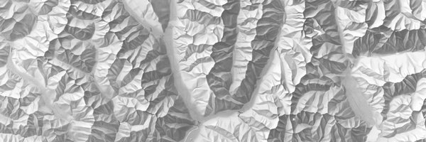
The Churfirsten DEMs range in resolution from 0.5 to 2,000 meters.
1
2
11
A manual shaded relief of Churfirsten, Switzerland, by Eduard Imhof. You can try emulating his style digitally with multi-scale DEMs of the same mountain available here: https://t.co/Dk4kJvV2oU
2
8
68
We are preparing new shaded reliefs for Natural Earth v6 with varying amounts of terrain detail. Available soon.
4
15
177

Carbon dioxide (CO2) plays a key role in the presence of life on Earth. It is also a byproduct of industrial activity, and we put more CO2 into the atmosphere than natural processes can remove. Watch a year of CO2 in Earth's atmosphere in this animated, interactive map:
0
7
18
Globes 1.2 for the #AppleVisionPro can now show globes of the David Rumsey Map Center as 360°-panoramas and place multiple globes side-by-side. https://t.co/sD6vdOHQWr
1
5
12
Crater Lake, Oregon with ambient occlusion. Read more about ambient occlusion in Cartographic Perspectives: https://t.co/rXoylrdVm0
https://t.co/JZuWPG34BX
0
5
38