
Tom Patterson
@MtnMapper
Followers
12K
Following
4K
Media
853
Statuses
2K
Retired public servant (US National Park Service). Love making maps!
Virginia, USA
Joined January 2018
Find georeferenced hand-drawn reliefs here:

#30DayMapChallenge Day 5 - Earth🌍, Map showing Shaded Relief Map of Earth in Orthographic form through Globe Builder Plugin , Data from @MtnMapper's Shaded Relief Archive website Link below #qgis #earth #data #globe #gischat
0
12
109

Just learned about the passing of cartographer Herwig Schutzler. Herwig's life was an adventure and his terrain shading with beautiful. Here are some examples you can find in the "Shade Relief Archive". Here is a story Herwig shared about his journey. https://t.co/PFUKfl4s0X
2
13
103
Hello/Hola/Olá - My South America Physical Map is now available. You can get it here (for free): https://t.co/QSvNCBxcUD
11
42
253

The community, the vibes, and the energy were truly unmatched! All weekend long, NYC came together at our first-ever CELSIUS Energy House to move, celebrate, recover, and recharge — all in true LIVE FIT GO fashion. We’ll be riding this high for a while!
31
13
187
Flattered to be included.

Accounts I recommend Cartographers @ClarkGeomatics
@JapanMapping
@verygoodmaps
@newgeographer2
@thisismikehall
@FleischerHannes
@MtnMapper
@MightofMe
@ManuscriptMaps
@DonatasBruzas Artists @ry_serene
@capstellium
@jasonjoyride
@usgraphics
@kristinatastic
3
0
13
Flowing both ways: Brazo Casiquiare connects headwaters of the Amazon/Negro and Orinoco rivers.
1
4
51
We are thrilled to introduce Eduard Cloud at https://t.co/GgLj0nHICi High-quality shaded relief for terrain maps can now be created on Windows, macOS, and Linux with any modern browser.
2
36
300

Style built for the spotlight. Crafted for performance. Blake Snell wears JAXXON.
0
9
81
WaPo article sorting out the naming of topographical protuberances by elevation. https://t.co/321jtltHzo
2
5
65
Preliminary type on my S. America physical map. There are 856 river and 391 peak labels so far. Coast labels are next.
3
4
79

Obstaja več kot 200 projekcij, po katerih so izdelani zemljevidi sveta, a kljub temu nam vsi dajejo popačeno sliko našega planeta. Če imate v glavi podobo sveta, po kateri sta Grenlandija ali Evropa skoraj tako veliki kot Afrika, živite v zmoti.

rtvslo.si
Obstaja več kot 200 projekcij, po katerih so izdelani zemljevidi sveta, a kljub temu nam vsi dajejo popačeno sliko našega planeta. Če imate v glavi podobo sveta, po kateri sta Grenlandija ali Evropa...
5
2
3
Started my next big map. All that it needs now are a few thousand labels ...
7
11
270
Heinrich Berann's beautiful panoramas of Denali, North Cascades, Yellowstone, and Yosemite national parks. Available for free: https://t.co/g85DoQNajy
0
2
48
A periodic update to my Prince William Sound, Alaska, map. Columbia Glacier has retreated another 1.6 kilometers since 2023. https://t.co/xj9VXLzOGu
0
15
133

FUTURES TRADERS: Get 40% off all evals, no activation fees, end-of-day drawdown in our live-market PRO+ accounts…and still daily PRO payouts!
13
5
106
Excellent geodata + stunning granite peaks + a cool name: The things that enticed me to map Cirque of the Towers, Wind River Range, Wyoming. https://t.co/TRR5ipId0e
9
64
644
Altitude is everything, especially on my new map of High Mountain Asia. Get it here for free: https://t.co/2ON59RaEes
6
24
189
By popular demand, here's another flipped version of Equal Earth centered on 90W. Available in English, Portuguese, and Spanish. https://t.co/GfjFaZHJk3
2
23
110

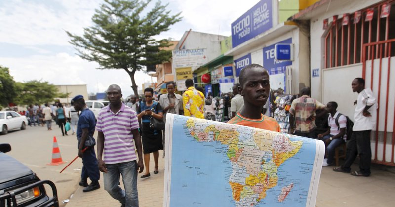
Another #EqualEarthProjection article: The Guardian view on Africa and maps: drawn true, its scale and promise can’t be ignored | Editorial

theguardian.com
Editorial: The push for fairer cartography rejects colonial shrinkage of a huge continent by the Mercator projection. This is not pedantry. It’s politics
2
4
14
The Equal Earth projection is gaining traction: African Union urges adoption of world map showing continent's true size
reuters.com
The Mercator projection fosters a false impression that Africa is marginal, an African Union official said.
5
15
50
The rough layout for my next map with a snow leopard thrown in for good measure.
2
2
76

Who says crypto has to be complicated? Meet our cutest educators yet: Cross River kids! They're helping us explore crypto concepts with clarity, curiosity, and a lot of charm! Watch the video to learn from the experts!
13
13
30
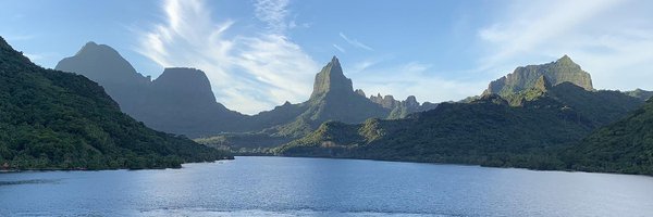
Enjoying trees, trails, and of course a map while on vacation.
1
3
62
Exciting news: The Equal Earth world map is now in Portuguese. Translated by Rafael Slonik—muito obrigado! You will find it here: https://t.co/GfjFaZHJk3
0
10
45