Explore tweets tagged as #spatialdata

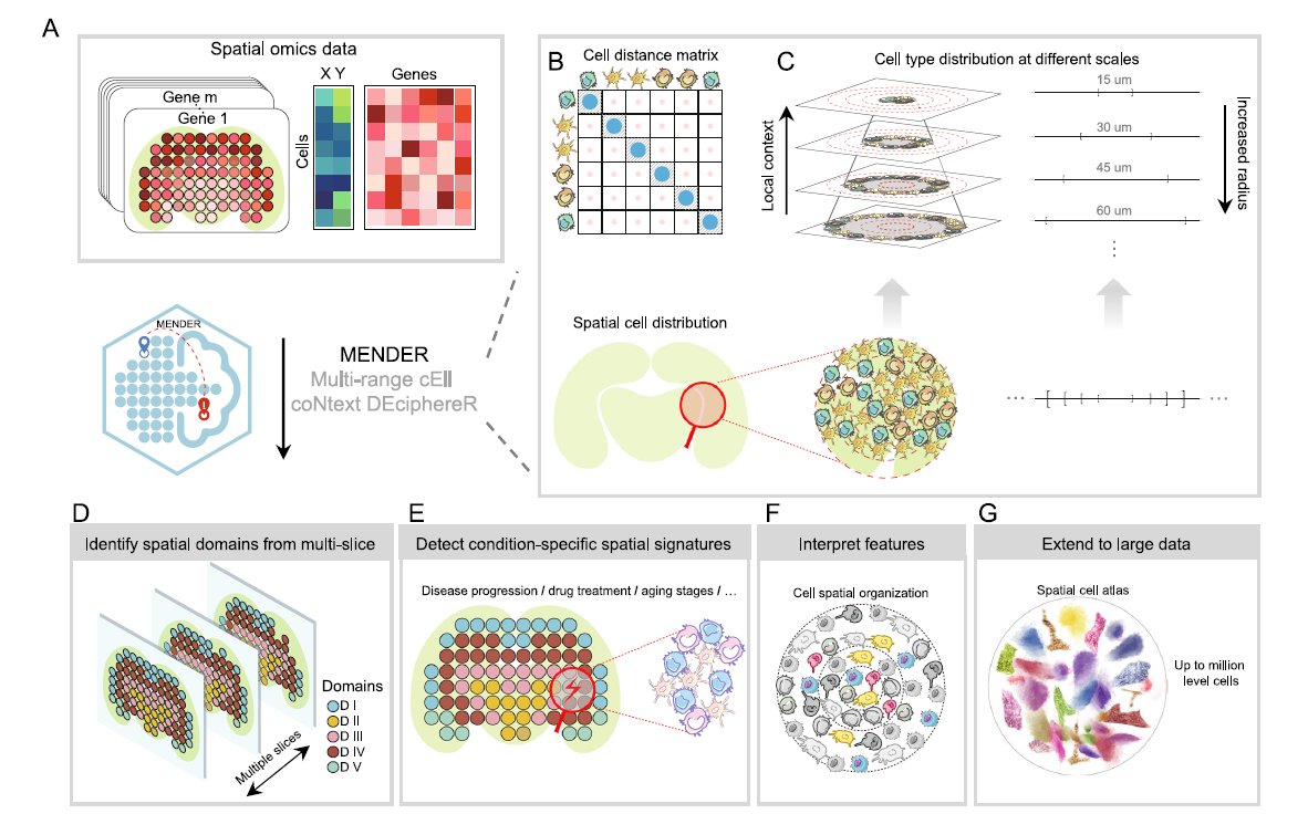
We love learning about new #ComputationalTools for analyzing #SpatialData! MENDER is a novel tissue structure identification tool utilizing cellular neighborhood structures observed across spatial technologies now published in @NatureComms. Learn more:.
0
12
49

Our colleague, Hesham Gaafar, will be leading a technical session titled " The Power of Indoor Mapping" at the GIS Day event at King AbdulAziz University. #EsriSaudiArabia #KAU #GISDay #KAUGISDay #Geospatial #GeoAI #GIS #Mapping #SpatialData #Geography #GISMapping

4
7
14

Spatial data science = unlocking patterns in location data📍. Think: predicting traffic jams or mapping disease spread. What's your favorite #GeoSpatial use case? #SpatialData #DataScience


0
2
2

It’s nearly lunchtime @foss4ge. Make sure to drop by our stand and say hello. We have experts in cartography, spatial data, web mapping, geocoding, JavaScript, and more!. #FOSS4G #FOSS4GEurope #foss4ge2025 #WebMapping #SpatialData


0
1
4

SpatialData: an open and universal data framework for spatial omics

2
4
25

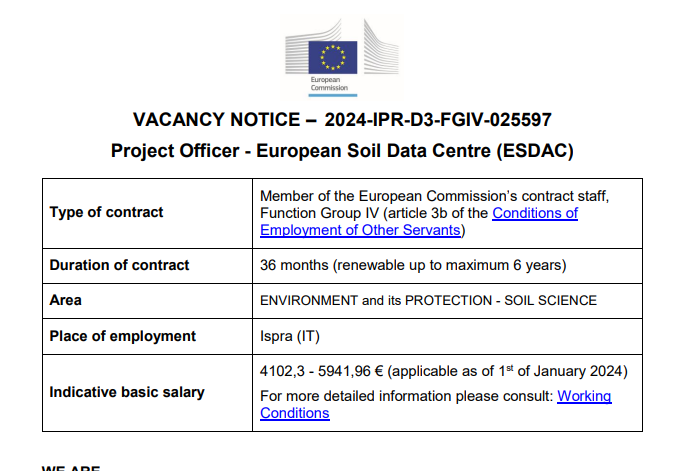
⚠️Job alert. We are looking for a scientist with PhD 🎓degree OR at least 5 years job-related experience in #soil science, #earth sciences, #data, #AI or #SpatialData & #RemoteSensing. Will work on 🇪🇺 Soil Monitoring system, Geostatistics, #bigdata
1
92
151

🌐.Introducing PA statistical methods: Geographic Information Systems (GIS). This integrates spatial data, ideal for exploring environmental influences on physical activity. GIS requires extensive data handling skills. #SpatialData #PhysicalActivityResearch

0
0
7

Meet Felt’s native H3 support. Just like all things we build, it really flies. Here are 3 reasons H3 in Felt is so unique ⤵️. #GIS #Mapping #SpatialData
3
10
35

Looking forward to working with @confeycollege TY students on their projects on Kippure and the river Liffey. We'll be using #spatialdata in #arcgisonline and using #storymapping to display their work. Get in touch to get your TY students invoved #believeinscience

0
1
2

SpatialData is a tool developed by EMBL scientists in cooperation with multiple research institutions to unify & integrate data from different omics technologies. It provides holistic insights into health & disease and is publicly accessible.

0
17
52

Looking for high-precision spatial data for AI, mapping, or autonomy? We’ve got what you need. DM us here on X — let’s talk data. #SpatialData #AIData #Geospatial #3DMapping #LiDAR #HDMaps #ComputerVision #MachineLearning #AutonomousVehicles #Robotics #SLAM #SensorFusion #DePIN.
0
0
3

2 WEEKS AWAY! 🥳 Prevent yourself from future FOMO & sign up for Esri's popular course today: #SpatialDataScience #ArcGIS #SpatialData
0
7
34

Why does Kontur use hexagons?.Because borders lie. Hex grids =.✅ Equal area.✅ Seamless coverage.✅ Fast queries.✅ No square bias.✅ Scalable from local to global. One shared frame. One honest view. #Hexagons #GIS #Geospatial #Mapping #Kontur #SpatialData

0
1
5

Your reaction to #VisiumHD data analysis may be somewhere between 🤓 and 😵. Wherever you land, join this webinar to see how intuitive and adaptable high-def #spatialtranscriptomics data exploration can be with tools like Bin2Cell & SpatialData.

0
5
12

Fresh on Towards Data Science - 𝐐𝐮𝐚𝐧𝐭𝐢𝐟𝐲𝐢𝐧𝐠 𝐓𝐫𝐚𝐧𝐬𝐩𝐨𝐫𝐭𝐚𝐭𝐢𝐨𝐧 𝐏𝐚𝐭𝐭𝐞𝐫𝐧𝐬 𝐔𝐬𝐢𝐧𝐠 𝐆𝐓𝐅𝐒 𝐃𝐚𝐭𝐚: . 𝐑𝐞𝐚𝐝 𝐦𝐨𝐫𝐞: #gis #datascience #maps #geospatialdata #datavisualization #spatialanalytics #spatialdata

0
2
9

#showcasing #students Jevaughn #spatialdata #analyst #Jamaica #ePortfolio #PLUS #creative #drone #projects #Check his #CV & impressive #skills list 😎 #data #visualisation #UAV #Copernicus #DigitalEarth #EO #GI #Geocommunication #UPOL #Geospatial #MSc
0
2
6

Join us next week to explore SpatialData, an #OpenAccess data framework for spatial omics. Registration is free but essential: #bioinformatics #datascience #computationalbiology #omics #multiomics #transcriptomics #singlecell #genomics #spatialomics

0
4
10


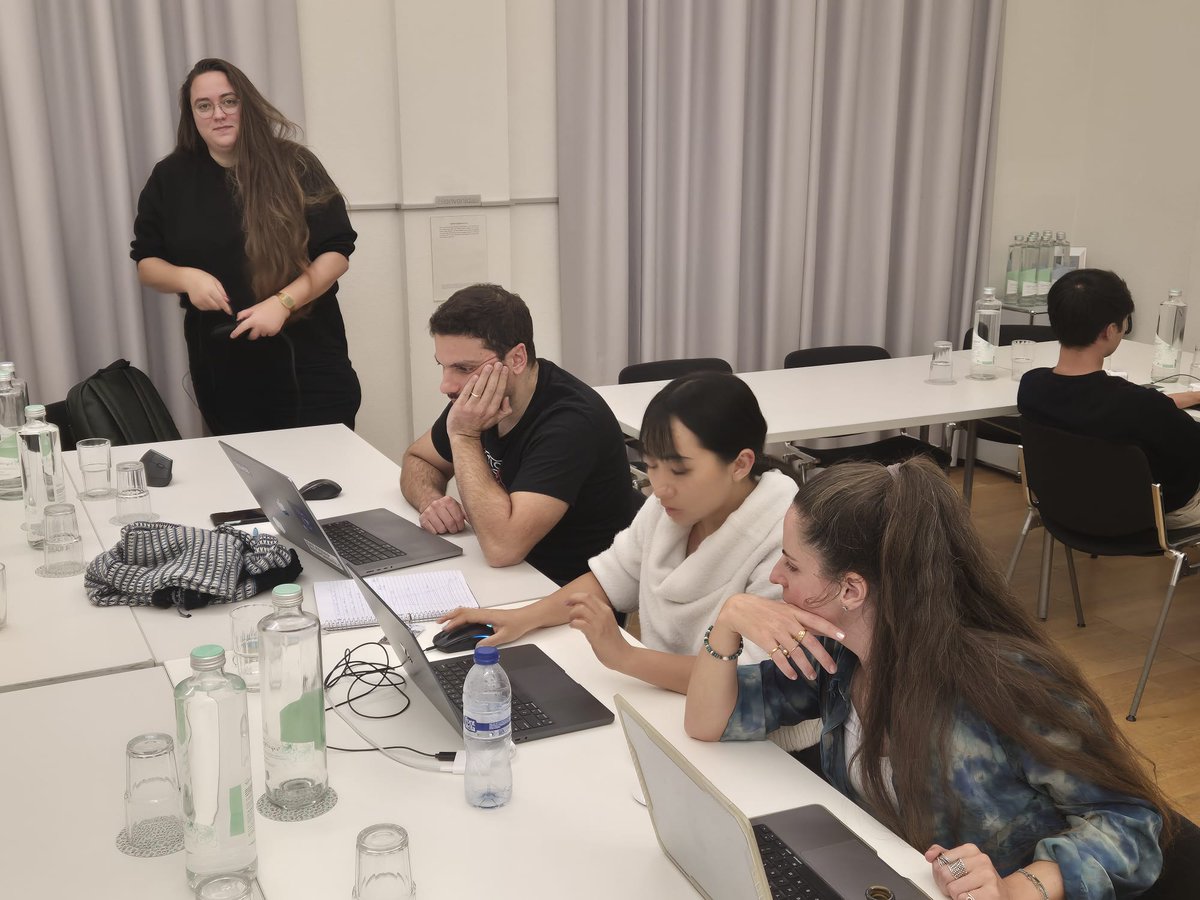
Recently, we held the first #scverse SpatialData 3-day hackathon in Basel (Switzerland), where we brought together 20 developers from the Python, R, and web communities to work on interoperability, performance, and ergonomics for spatial omics data. Here is what we worked on!

1
8
26