

Gisli Olafsson
@gislio
Followers
11K
Following
19K
Media
2K
Statuses
22K
SecGen of Icelandic Red Cross. Father of five. Humanitarian. Author of The Crisis Leader - https://t.co/iZW8a6ZYtx - Views are my own!
Iceland
Joined April 2007
Happy to announce a cheaper paperback version of The Crisis Leader. By printing the few images inside of it in. http://t.co/cxF5P8rXBh.
12
13
87
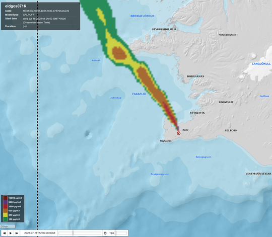
The fissure erupting is between 700 and 1000m long, and the eruption is expected to be short-lived. There is a gas cloud extending from the eruption - the attached map shows where the concentration of SO2 is expected to be high over the next 6 hours.
0
2
14
Icelandic Civil Protection (@almannavarnir) has declared an emergency phase after an #eruption started near Litla Skogarfell, north of the town of #Grindavik. So far, the eruption is small and does not pose a threat to any infrastructure or people.

1
4
21
The view of the #eruption near #Grindavik as seen from Reykjanesbraut - the road between @kefairport and Reykjavik. No flights are affected by this eruption - they only get the bonus of seeing a live eruption from the air.

1
4
21
The 12th #eruption near #Grindavik started at 03:54 GMT, four hours after magma intrusion began. The area has been safely evacuated, and access is currently restricted. The eruption can be seen from the road between @kefairport and Reykjavík. Flights are NOT affected.

2
28
105
A volcanic #eruption has started near #Grindavik. Location is similar to previous eruptions. Photo from @RUVfrettir stream.

1
9
28
Magma has reached the surface and an eruption has started. Photo from

1
1
9
GPS data indicate that a magma intrusion is occurring in the same area as in previous incidents. The amount of magma is less than earlier. If the quakes stay at a similar depth, then the likelihood of magma reaching the surface is reduced according to @Vedurstofan.
1
1
5

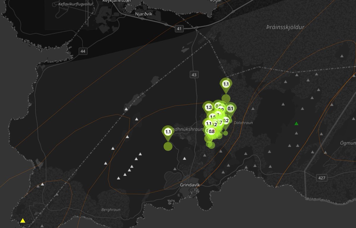
The Icelandic Meteorological Office (@Vedurstofan) has issued a new hazard map for the Reykjanes peninsula, including #Grindavik. The main threats are along the path of prior fissures in the area.

1
3
5
The magma intrusion is still ongoing and appears to be at a depth of 5-7 km. This is quite similar to the last eruption, where the magma intrusion only reached the surface after a considerable amount of time, and the eruption was very short-lived.

1
3
3
Civil Protection in #Iceland - @almannavarnir has declared an Alert Phase due to magma intrusion and likely imminent #eruption near #Grindavik. The area is being evacuated, and access is restricted. The National Emergency Operations Center has been activated.
1
3
7
The town of #Grindavik and its surrounding areas, including the #BlueLagoon and the Grindavik campsite, are being evacuated. Access into Grindavik is restricted as roads are being closed.

1
10
12
There are three different signs they use to determine a magma intrusion. First is an earthquake swarm in the area. The second is increased pressure in boreholes. Third is the rapid movement of fiber optic cable in the area. Currently, all three are present. #Grindavik.
1
4
9
According to @Vedurstofan a magma intrusion has started near #Grindavik with the likelihood of an imminent #eruption being high. #Iceland #volcano
1
13
30
Eruption has breached the defensive walls that are north of Grindavik than

2
5
6

Eruption has started near Grindavik - right by defensive walls.
2
0
4

RT @MyanmarRedCross: 🚑 #RapidAssessment & #FirstAid in Action. Our Rapid Assessment Team in #Mandalay (March 30) is providing first aid and….
0
9
0