
Team Bolt
@TeamBoltWX
Followers
2,285
Following
56
Media
3,173
Statuses
6,717
We are a group of weather enthusiasts, devoted to saving and protecting the lives of people through weather updates. Contact us via our website in our bio.
United States
Joined November 2022
Don't wanna be here?
Send us removal request.
Explore trending content on Musk Viewer
Drake
• 1089218 Tweets
Rocky
• 274254 Tweets
#BANOBAGIxTEN
• 230206 Tweets
みどりの日
• 98561 Tweets
Meet the Grahams
• 96296 Tweets
#แบมแบมอินราชมัง
• 96030 Tweets
#ENCOREAREA52DAY
• 95745 Tweets
WNBA
• 74336 Tweets
#CvittMorninglympicxซีนุนิว
• 58688 Tweets
Clippers
• 50885 Tweets
Kyrie
• 49107 Tweets
スパコミ
• 48406 Tweets
Kenny
• 43726 Tweets
Aubrey
• 37748 Tweets
Canucks
• 37284 Tweets
ANOTHER CHILD
• 33704 Tweets
Mavs
• 33291 Tweets
水分補給
• 31385 Tweets
Adonis
• 31028 Tweets
Caitlin Clark
• 30864 Tweets
#30thAnniWARsary
• 29613 Tweets
Cavs
• 28937 Tweets
Kul Ka Crown
• 26954 Tweets
Pusha T
• 26445 Tweets
Kdot
• 22663 Tweets
Mavericks
• 18275 Tweets
設営完了
• 16939 Tweets
Hip Hop
• 15845 Tweets
Drizzy
• 14744 Tweets
Marlins
• 12401 Tweets
Donovan Mitchell
• 11484 Tweets
Arraez
• 11406 Tweets


53
408
1K
18
213
763
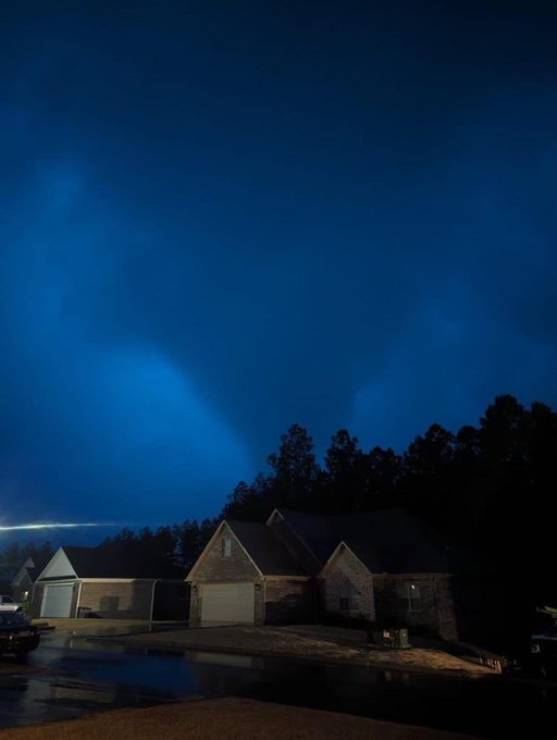
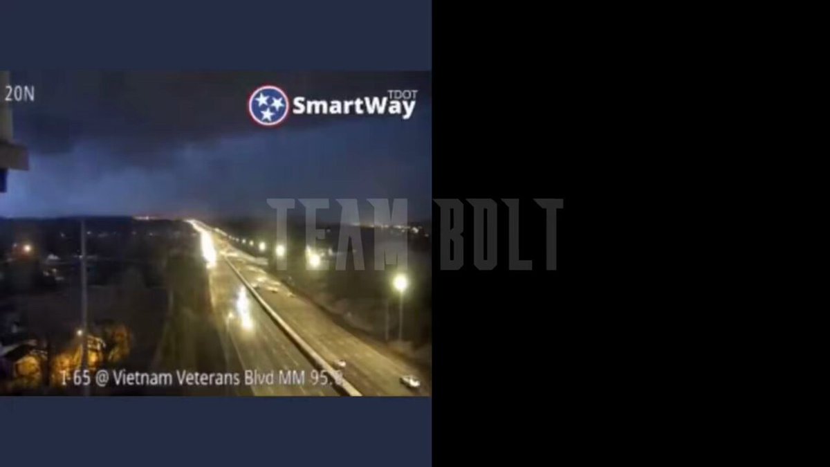
The new security footage from
@NESpower
has came out of the power substation that blew up in the Madison/Hendersonville. We have sinked it with the TDOT Smartway camera showing the tornado.
@NWSNashville
11
84
344
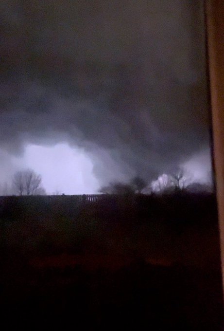
EXCLUSIVE: TORNADO VIDEO IN HENDERSONVILLE, TN.
@ryanhallyall
@NWSNashville
@ReedTimmerAccu
@weatherchannel
@WeatherNation
@accuweather
@WSMV
@WKRN
@NC5
@NC5_BreeSmith
@JimCantore
Please give proper credit if you use this.
12
116
269
8
81
241
We are now getting reports of “complete deviation” in Hendersonville and that parts of Nashville are a “complete war zone”. Please do not go look at damage tonight in Nashville. It is URGENT that emergency crews are able to do search and rescue.
10
73
223
6 people now confirmed dead in Indian Lake, OH by news sources.
Most of the deaths occurred inside mobile homes.
12
68
209
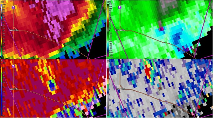
Guess the rating and tornado that produced this DI:
A - 🟪 EF5
B - 🟧 EF3
C - 🟥 EF4

212
12
165
Has your state ever had an EF5 tornado?
Comment below what tornado was it!
👇👇
87
15
148
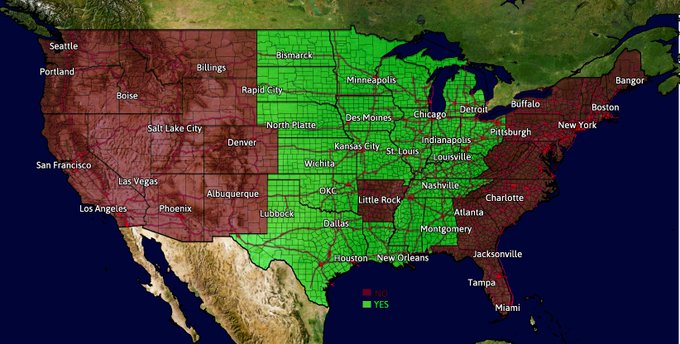
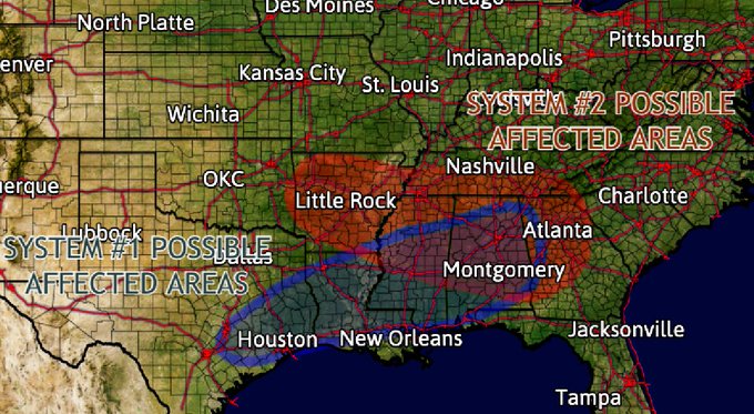
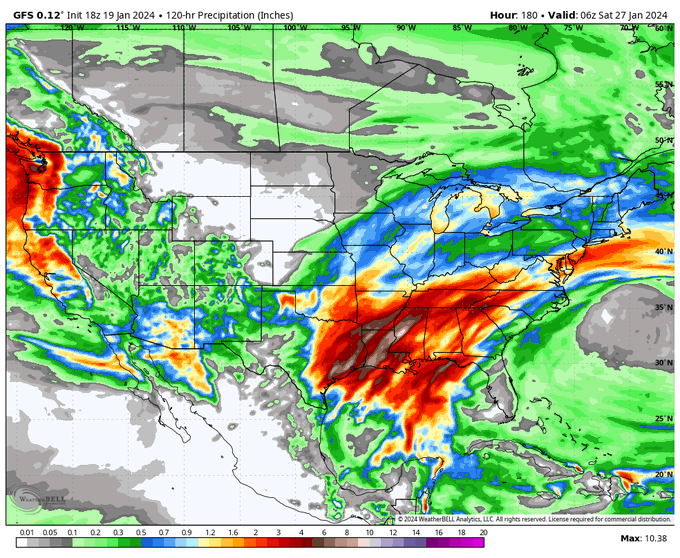
A severe weather event looks like it could take place from January 22-28, with two systems impacting the southeastern US, details below:
The first system threats look unclear. This system could impact areas across the southern US, including cities such as Houston, New Orleans…
9
29
144

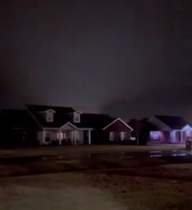
TAKE A LOOK: Here are all of the tornado clips we have of the Nashville/Hendersonville tornado today all synced together.
@NWSNashville
@ReedTimmerAccu
4
44
139
The first half of January will be quite active as many pieces of energy will fly down from the north, causing big winter storms, rain, and severe weather. We will keep you updated as each storm unfolds.
8
21
127
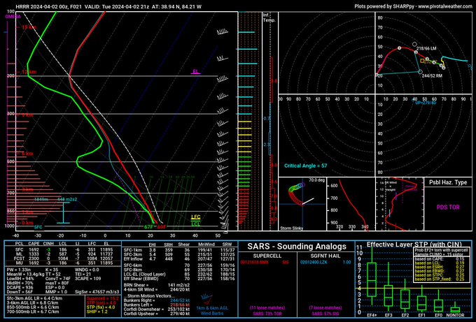
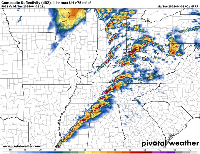
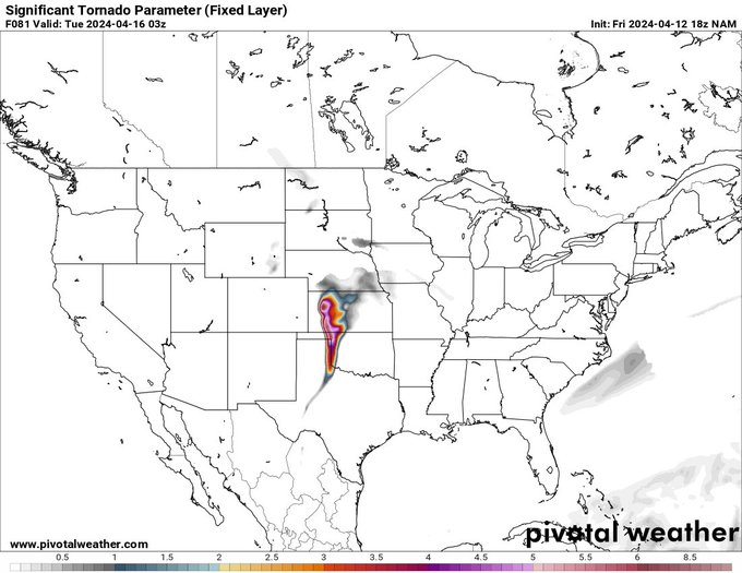
0Z model guidance suggest a more widespread area for tornadoes across the Ohio Valley with long tracked, significant tornadoes possible. More details below:
[1/? 🧵]
#severewx

6
32
125
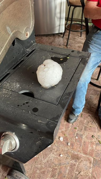
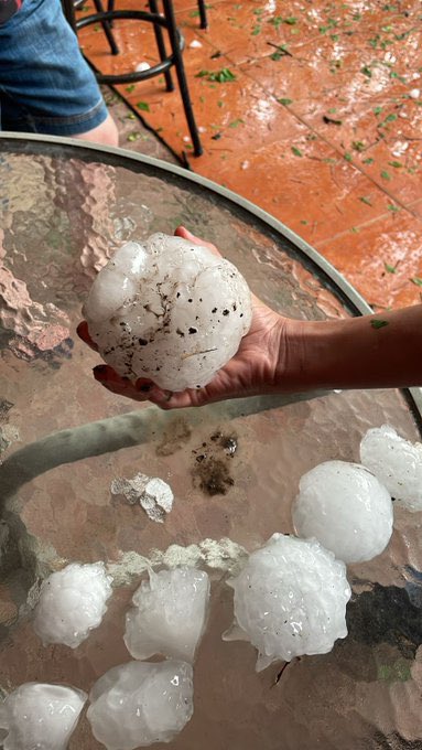
WOW, insanely big hail fell in
#Cohuila
, Mexico yesterday. Just look at the size of that thing.
@ReedTimmerUSA
#hail
#mxwx
📸 •
@jlfede1
4
36
122
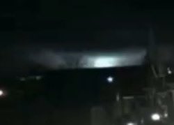
Video of an incredible rope out from the Madera tornado minutes ago!
📸 Jacklyn Walton
3
25
119
Hope everyone had a great New Years Day! Lets play a little game. Out of these 4 images, one of them is AI generated. Can you guess witch one it is?

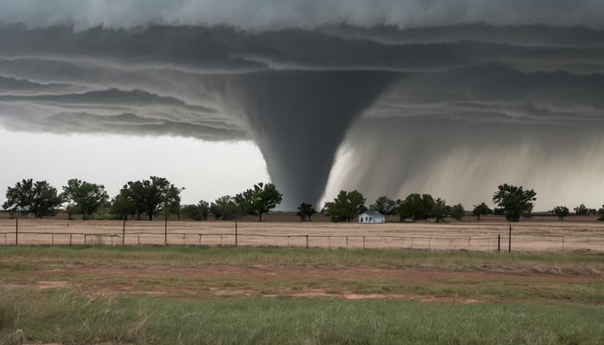
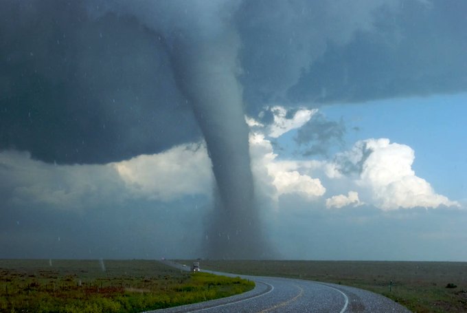
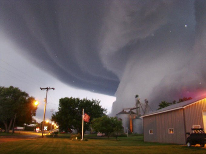
55
7
114
Possible
#tornado
earlier today near East End, minor tree damage reported.
📸: Stephen Freeman
3
23
117
Here is a picture of the tornado in Panama City of the tornado as it came on shore from Craig Edwards
5
30
106
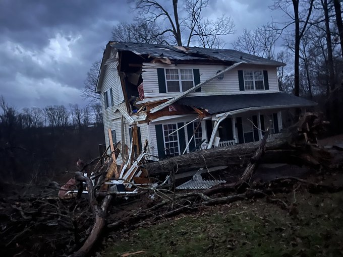
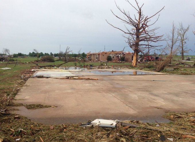
Tornado damage in Sunbright, TN after a strong multivortex tornado went through town.
📷・Justin Sunbright
8
28
106
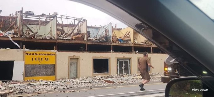
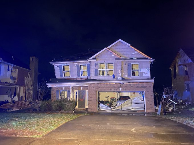
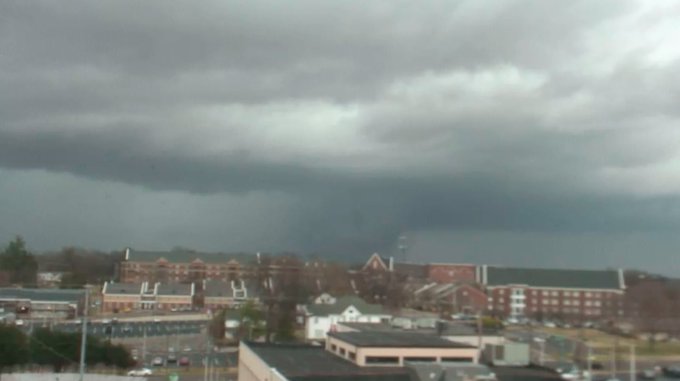
A Bowling Alley with around 40+ people inside has collapsed in Hendersonville.
4
30
103
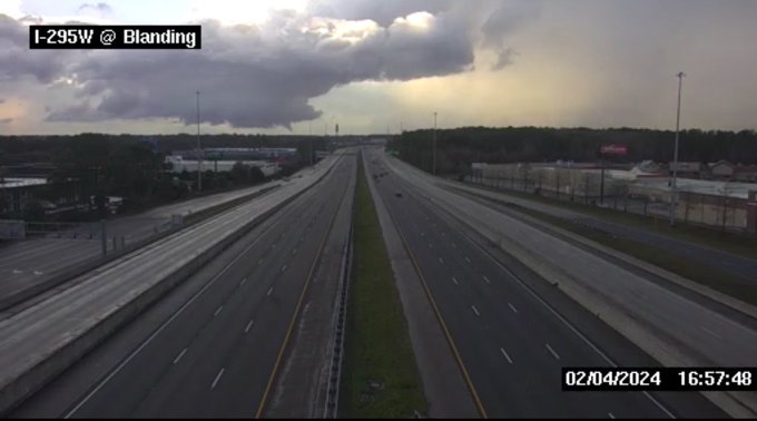
WOW. This camera was in the direct area of interest in the hook of the tornado warning in Jacksonville, FL. VERY powerful storm.
6
25
101
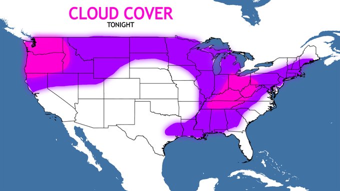
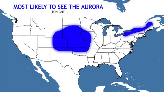
🚨 AURORA ALERT 🚨
A strong geometric storm is in forecast for tonight witch means the aurora will likely be visible across the US. However, as you can see in the map on the left, most of the US will likely see a good amount of cloud cover tonight witch means most areas will not…
10
22
98

Good morning to everyone!
Yesterday was a devastating day for parts of central
#Tennessee
and southern KY. One of the strongest tornado of the day impacted the city of Clarksville, leaving three fatalities and more than 30 injuries. (as of morning 10/12)
Here we have one of…
4
26
88
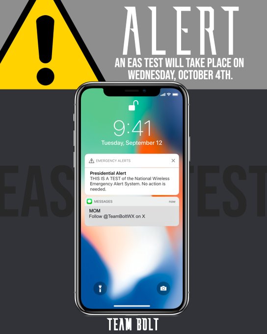
🚨IMPORTANT🚨
A test of the EAS (Emergency alert system) will take place on Wednesday. Keep in mind that your phone WILL go off for a TEST on Wednesday.
10
42
84
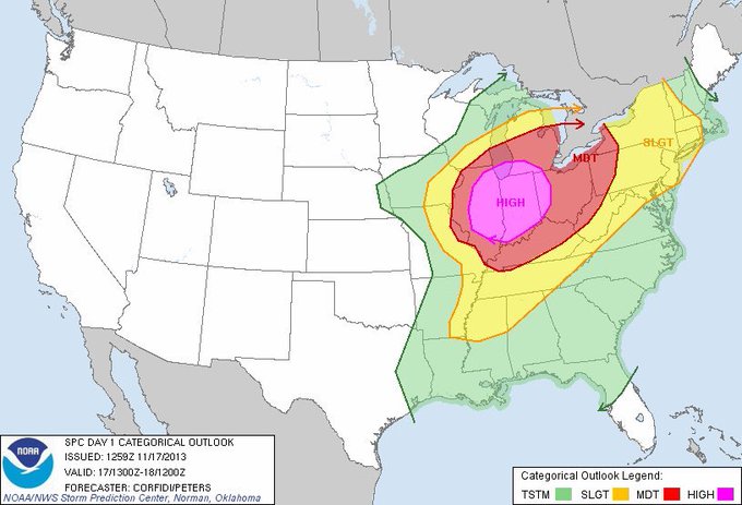
Today marks the 10th anniversary of the forgotten tornado outbreak of November 17th, 2013. What risk were you in?

34
18
85
We are eyeing the potential for a winter storm in early February. We don’t know the exact details yet but we do know this is a solid signal for a southern winter storm.
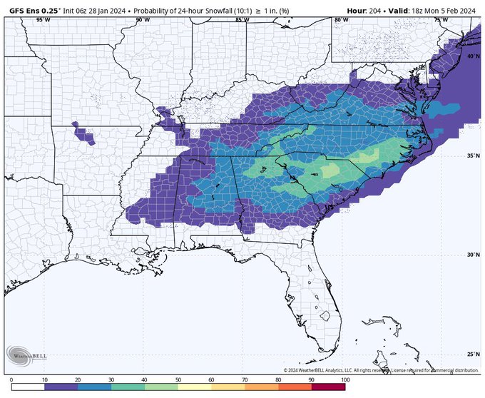
11
17
84
We are absolutely heart broken about the events that have taken place across TN and KY tonight. Our team has worked tirelessly tonight on getting info out to you. But most of all, we would like everyone to give a round of applause to
@PettusWX
who was watching some of the town…

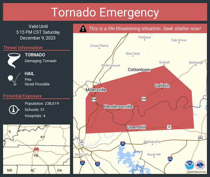
4
20
82
MORE TORNADO FOOTAGE FROM THE INTENSE
#TORNADO
THAT WENT THROUGH VALDOSTA, GA AN HOUR AGO.
Credit in replies:
2
29
80
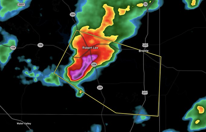
LARGE CONE TONADO ON THE GROUND TO THE NORTH OF CLARKSVILLE TN. RUN TO SHELTER NOW.
2
23
78
Weird looking 7 like feature on the pacific right now! Almost looks like it’s forming a 76.
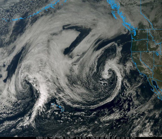
5
18
79
Something that isn’t being talked about with this Enhanced Risk is that we will not have ANY good radar data in the main risk area. Houston’s radar (KHGX) is down for maintenance. This could be a big issue as the City of Houston and surrounding areas will have virtually 0…

13
25
77
AT LEAST 4” sized hail today in Mexico as very strong storms cross the border into TX. Very impressive.
@ReedTimmerUSA
📸 •
@TiempoCarbon

1
28
76
18Z data is in and we have some concerning trends & changes from 12Z data, in this thread we will go over the main changes for each model aswell as our final thoughts for Monday.
[1/? 🧵]
#severewx


4
13
75
It has been nearly 27 years since the historic Jarell, TX tornado, and we decided to make a small thread about this violent tornado where sadly 27 people would lose their lives and left 12 others injured.
1/3
5
14
73
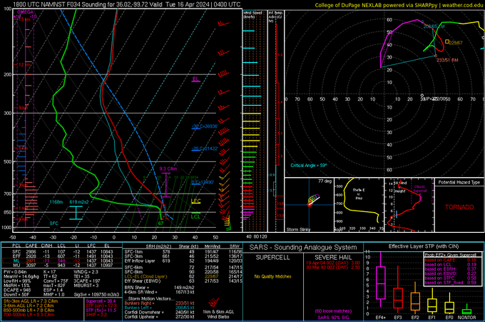
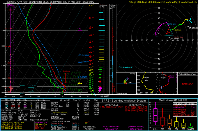
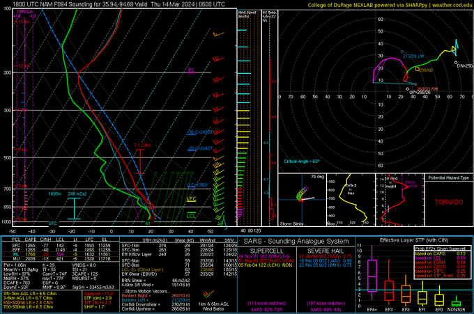
Confidence is increasing on a significant tornado outbreak across the plains on Monday w/ potentially strong tornadoes, recent NAM runs have trended towards a very volatile environment across the area.
[1/?🧵]
#severewx


6
20
73
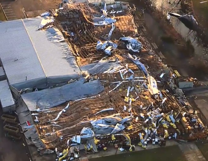
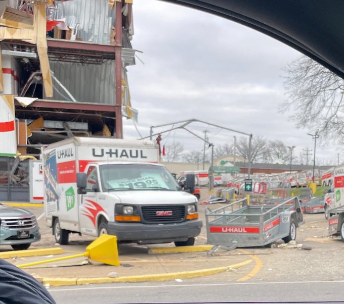
Here is some very bad damage to what looks like some sort of warehouse in Springfield, TN

2
25
71
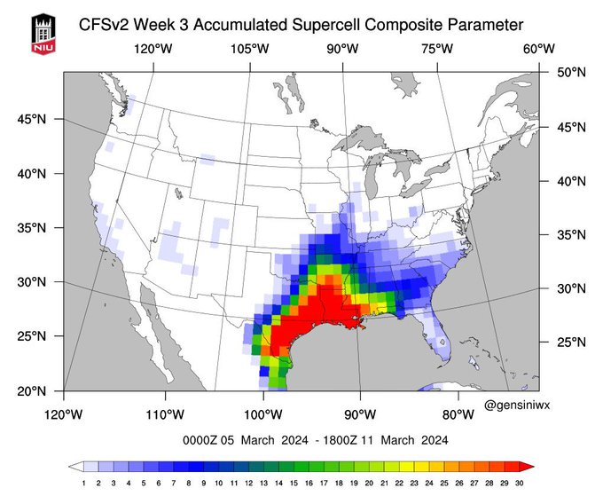
Very interesting model showing decent severe weather probabilities across the south around the first week of March.
Not a forecast as things can change.
1
8
71
1
27
72
Looks to be a warm nose inhibiting accumulations west of Portland.
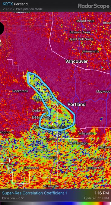
22
5
69


Fact of the Week:
Mayfield, KY was almost struck by a strong EF3 tornado in May 2016, only 10 injuries resulted from this tornado, and thankfully it missed the town to the north.
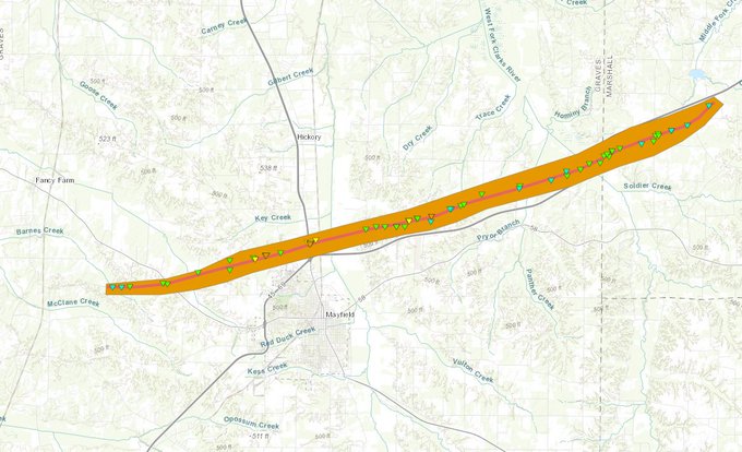
3
8
68
This is the most accurate map your going to find regarding the possible snow event for THU-FRI.
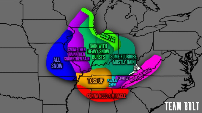
11
11
66
A massive chemical explosion has occurred in Shepard Texas. Shelter in place alerts have been issued and air quality alerts should be up shortly.
14
35
65
Another burst of convection is shown on satellite with
#Idalia
. This will likely be the one that makes this storm a hurricane. This thing is about to get real, fast.
3
12
65
The new tornado watch features a 80/50% probability meaning that there is an 80% probability of two or more tornadoes and a 50% probabilities of one being significant

2
24
66
Here is the power grid that blew up after taking a hit in Madison, TN near the Art Immortal Tattoo shop.


3
12
66
Here are some notable things happening to the NWS in 2024.
- Special Weather Statements and Advisories will no longer be wished by the NWS.
- A new, more “understandable” language headlines to more clearly describe weather or water hazards (replacing statements and advisories)
1
20
63
Sadly one of the fatalities from Jan 8th-9th severe weather and tornadoes happened in a mobile home.
Mobile homes are the worst place to take shelter in during storms and tornadoes. Weak tornadoes can unfortunately kill people if adequate shelter is not taken.
This mobile home…

5
23
60
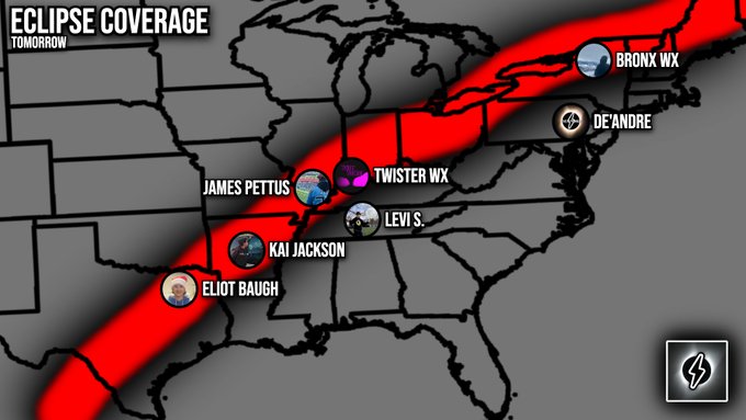
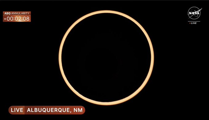
We are ready to go! We will have 7 people out in the field tomorrow to bring you eclipse coverage. Also, we do have a few people staying back to cover the severe weather threat we have tomorrow. Stay tuned.
#EclipseSolar2024
9
11
63
BREAKING: A State of Emergency has been issued for Tennessee following yesterdays tornadoes.
0
26
62
Checkout this timelapse montage of the tornado warnings in west Jacksonville.
@NWSJacksonville
3
18
61
A new EF2 tornado has been confirmed in SE Ohio, this brings our tornado total to 19 with 4 of them being strong. (EF2+)
Could see an additional tornado be confirmed.

5
11
61
Looks like we could have an active May across tornado alley this year w/ long range models trending that way. We've decided to do a thread to share our thoughts & opinions about May.
[🧵1/?]
#severewx

5
14
62
It is the first middle of nowhere Texas hail storm of the year 🥳
3
7
60
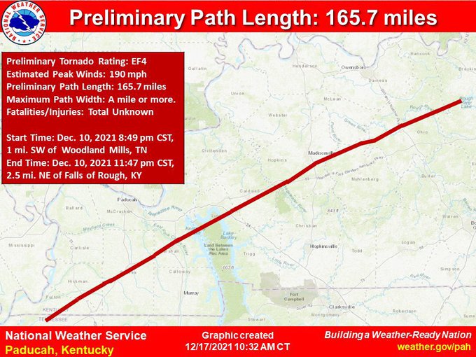
To day is December 10th. And on this date in 2021, parts of eastern Arkansas, Tennessee, and Kentucky were devastated by strong and violent tornadoes. Most of the areas hit by these tornadoes have yet to even recover. There are some great case studies on this event on YouTube if…
1
23
60
The Evansville, WI tornado has been given a preliminary EF3 rating with winds up to 140mph.
4
10
60
Guess the rating and tornado that produced this DI:
EF-4:🟥
EF-3:🟧
EF-2:🟨
Good Luck!
55
4
56
Almost 11 months since the historic Rolling Fork tornado ravaged across parts of Mississippi, one of the most deadly and catastrophic tornado of this decade, we made a thread below highlighting the tornado track, setup and aftermath.
🌪 ・ Tornado Track
The tornado touched down…
5
13
55
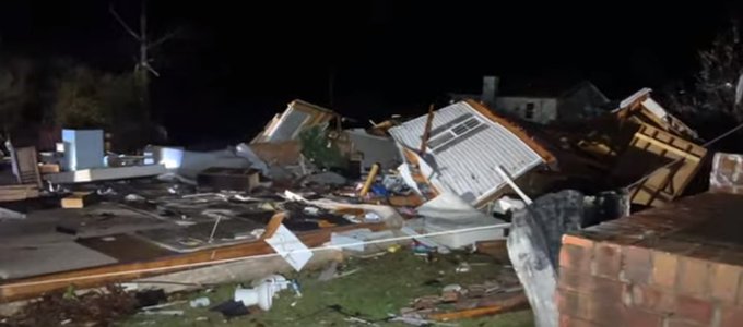
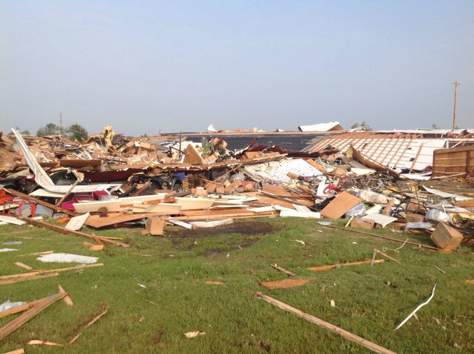
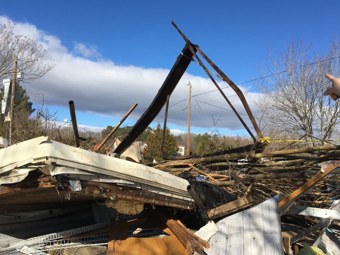
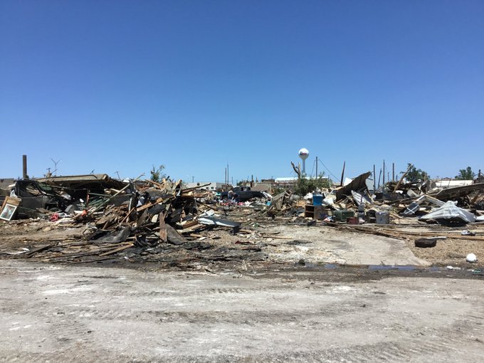
Some more damage pics from Madison and Hendersonville from a friend of Team Bolt’s

2
18
56
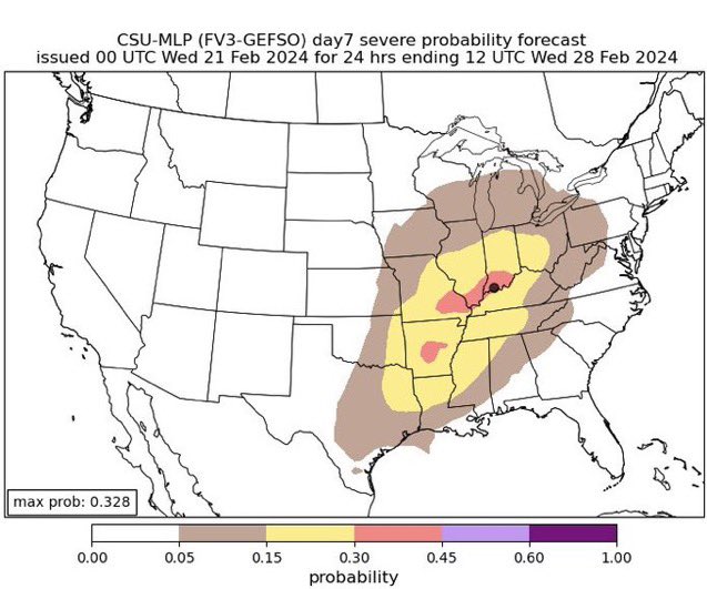
CSU showing some probabilities for severe weather from the Ohio Valley to South Central CONUS, this is just a model and not a forecast but it’s certainly something to watch out! 👀
1
12
55
What in active two days across the South East. 24 total tornado reports were reported.
Source: SPC

3
21
55
The full official “Twisters” trailer.
Credits to Universal Pictures.
1
15
55
Here is
#Idalia
in 3D using
@RadarOmega
It is really fascinating to see the true complexity and size of this storm.
3
12
56
We have eyes on a *POSSIBLE* tornado entering Nashville. We need more confirmation. However, it is not what you want to see coming into a major metro area.
3
22
55
BREAKING: Florida governor Ron DeSantis has issued a State of Emergency for 33 counties ahead of what is about to be Tropical Storm Idalia.
#flwx
4
22
52
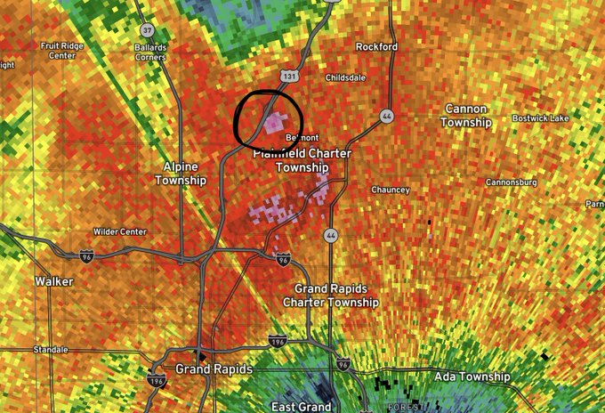
That was a big debris ball on the tornado that just went through the northern suburbs of Grand Rapids, MI.
1
12
52
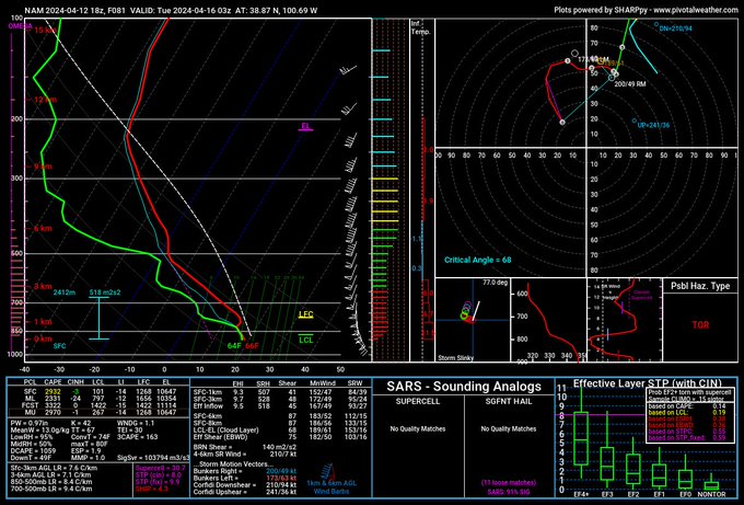
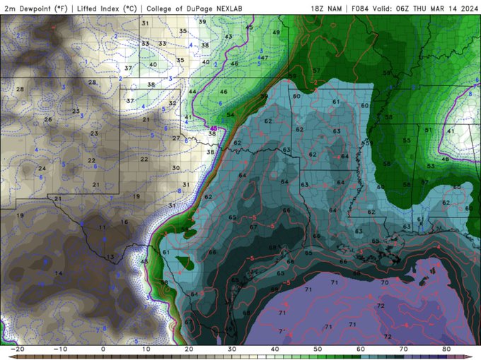
NAM is starting to get in range for the Wednesday-Thursday event and shows an environment favorable for all hazards with a classic dry line setup across the plains.
🧵1/?
2
12
54
12Z Euro runs are starting to come in and looks to have uptrended for the Ohio Valley, it is still too far out to determine what and where will it happen, but we are getting there.
4
15
51


Getting more confident about a potential severe weather outbreak on Monday across the central to southern plains, with potentially discrete cells capable of tornadoes & large hail.
[🧵1/?]
#severewx


2
12
53
@ReedTimmerAccu
We made an edit of them all synced up
TAKE A LOOK: Here are all of the tornado clips we have of the Nashville/Hendersonville tornado today all synced together.
@NWSNashville
@ReedTimmerAccu
4
44
139
3
12
53
We have now had over 138 waterspout/funnel reports on lake Erie today so far. I'd say it is fair to call this a full blown spoutbreak.

1
11
51

2
3
52
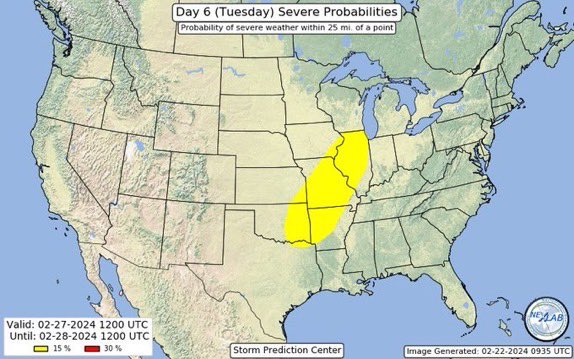
Severe weather looks possible early next week with decent model agreement for this event, the SPC has already outlined an area for severe weather on Tue. and Wednesday.
| Details Below |
🧵1/?

The SPC has highlighted a 15% chance of severe weather for Tue. and Wed. for parts of the southern Ohio Valley.
Threats are still unclear and we will be monitoring it closely.
1
6
25
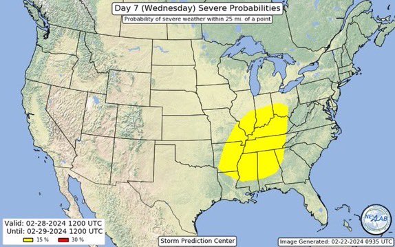
2
11
49
We are seeing a solid signal for a severe weather event in Dixie Ally. Don’t pay attention to any locations at this point as we are way far out but this is a solid signal from analogs and models. The most likely time of this event will be late February into early March.

3
8
50

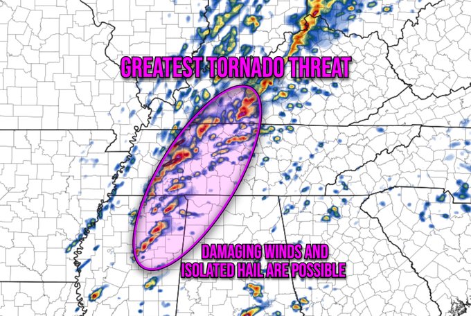
Here is where we think the greatest tornado potential will be. Damaging winds and isolated hail are possible. Full in-depth model analysis will be coming shortly for all of you nerds out there.
5
16
51
🌪・Guess the rating that was assigned to this DI:
A) ・ EF3 🟧
B) ・ EF4 🟥
C) ・ EF2 🟨
46
7
49
Tornado fact of the week: 🌪
One of the longest tracked tornadoes (6th place) is an underrated/not well known tornado that occurred on May 24th 1965 earning an F1 rating. This tornado was estimated to have tracked 176.4 miles with a max width of 10 yards.
No pictures exist of…
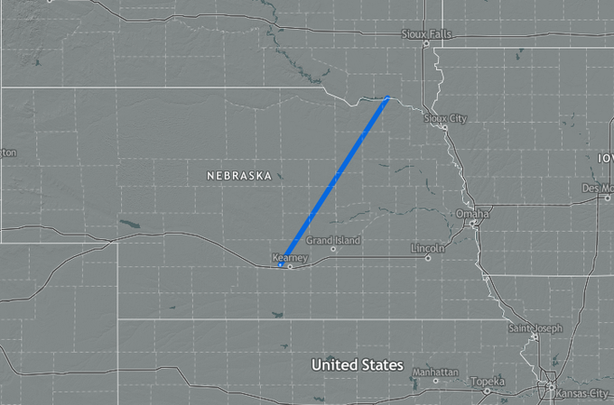
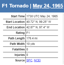
6
9
48
🌪️ • What tornado rating was assigned to this DI?
a ) EF3
b ) EF4
c ) EF2
#wxtwitter
#tornado
45
4
49
FROM NASHVILLE EMERGENCY OFFICIALS:
The Nashville Office of Emergency Management is partially activating the Emergency Operation Center (EOC) to coordinate resources for the ongoing severe weather impacting the Metro Nashville Davidson County area.
Representatives from…
1
18
49
From a monster Cat 5 storm to a Post Tropical Cyclone, here is what
#Lee
looked like using Zoom Earth.
1
22
49