
Shea Gibson
@SheaGibsonWx
Followers
5K
Following
18K
Media
12K
Statuses
28K
Meteorologist - Wind Forecaster for WeatherFlow - Sail Race Forecasting - Tropics - Outreach - New Weather Station Projects - AMS Member - WRN Ambassador
Charleston, SC
Joined November 2012
Seriously cool pic here.

Naked eye 704pm nw Lancaster co nebraska. @NWSOmaha @WxRentschler @weatherchannel @JessicaBlumWx @rustywx @LukeDorris @N9XTN
0
2
3
Just keeps getting better! This one from Daniel Barron as captured from the Isle of Palms Marina, SC. #chswx
0
2
5
11/11/25 Tuesday 9pm: Here are other shots of the Northern Lights as captured in Awendaw, SC by Chris West. It's better if you catch it in the country! @NWSCharlestonSC #chswx @CarolinaWxGroup
0
2
3
11/11/25 Tuesday 9pm: A severe geomagnetic storm (G4) is happening now. We weren't technically in the window to see the Northern Lights all the way here in Charleston, SC, but I can see a slight reddish/purple hue to the northwest right now with the naked eye. I was able to
0
2
6
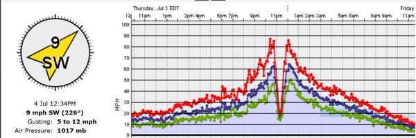
Chilly start with 29° at the airport and 32-34° at the coast. Wind chills are in the low-mid 20's so bundle up as you head out. Brrr! A large dome over the Gulf states expands east, making for a moderate WNW/W gradient that slowly relaxes through the day. Winds: We start WNW
0
0
2
This little short wave heading across the SC/NC border could continue to wrap a few flurries around it all the way to the coast. Already seeing some from western Charlotte and down to Lake Wylie per my buddy Chad Carson! Heads up if you live along the border counties and over to
0
1
2
Got some eyewitness accounts of flurries all the way to western Charlotte and down to Lake Wylie. This slug of NW flow is packing more punch than expected. Some of that frz precip is making it down into the SC upstate and Atlanta, GA as well. Just flurries with no measurable
0
1
3
Here we go tonight with a big freeze across the SE Region. Freeze Warnings are up for all of SC tonight from anywhere from 8 or 9pm tonight to 9am Tuesday morning. There are Winter Storm Warnings up for the higher elevations of the Appalachians as NW flow persists off the Great
1
1
9
Awww so it ain't so. :( The Farmers' Almanac has been the nostalgic backbone of weather and agriculture...along with so many other culturally useful nuances they taught over the years. Hate to see this outfit go away after so many years of dedication!
0
0
2
A new WxFlow Pro Net sensor was born yesterday in the Tidewater, VA area near 11AM ET at Factory Point near the entrance to Back River. @NWSWakefieldVA / @NHC_Atlantic it is located at 37.1086, -76.2974 with callout XFAC per MADAS for your AWIPS II plotting. Height = 19ft AGL.
0
0
3
EURO digging down deep

Cold air outbreak next week will certainly turn on Lake-effect snow. However, it’s a very progressive pattern and without a closed UL Low sitting over James/Hudson Bays, you will likely not get heavy, long-lived snow events on SW or W fetch off the Lower Lakes.
0
0
3
Nice batch of Asperitas clouds (f/k/a Undulatus asperatus) over Charleston, SC a little while ago. Those stiff upper level SW winds are creating some ripples in the stratus decking from above. Like wind over water. Beautiful. #chswx
0
0
5