
NOAA Satellites - Public Affairs
@NOAASatellitePA
Followers
32K
Following
924
Media
3K
Statuses
5K
@NOAASatellitePA is managed by NESDIS Public Affairs. @NOAASatellites are the backbone of @NOAA's life-saving weather forecasts.
Silver Spring, MD
Joined April 2014
The U.S. Government is closed & this account will not be updated. @NOAA websites & social media necessary to protect lives & property WILL be maintained.
0
4
9

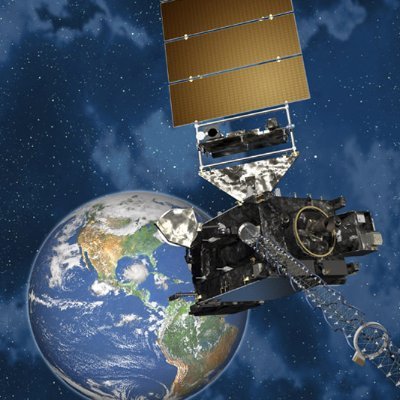
Just in: @NOAA’s SWFO-L1 observatory heads to orbit for groundbreaking mission New #satellite will advance space weather forecasting --> News release + launch video: https://t.co/58q5oEsVYS
@NOAASatellitePA #SWFOL1 #SpaceWeather

noaa.gov
New satellite will advance space weather forecasting
2
6
13

T-minus 17 hours! 🚀 @NOAA’s #SWFOL1 🛰️ is scheduled to launch at 7:30 am EDT tomorrow, flying together with @NASA’s #IMAP and Carruthers Geocorona Observatory! 📺 Our live launch coverage will begin at 6:40 a.m. EDT here on X, Facebook, and https://t.co/mzqJZKXw2f 🕣
1
22
95

Isn’t she a beauty? 😍🚀 @SpaceX’s Falcon 9 rocket is on the launch pad @NASAKennedy! @NOAA's #SWFOL1 is all tucked in with #IMAP and #Carruthers. We’re looking forward to a picture-perfect liftoff with our cosmic carpool! Join us for the launch tomorrow morning at 7:30 a.m.
🚀 Three Missions. One Rocket. IMAP, SWFO-L1, and Carruthers are aboard the SpaceX Falcon 9 and ready for liftoff at Kennedy Space Center's Launch Complex 39A! Launch is targeted for 7:30 am EDT, tomorrow, Sept. 24. https://t.co/3bLRRFdzvi
2
5
31
Today is the first full day of #AstronomicalAutumn in the Northern Hemisphere! This #timelapse imagery features one image per day from @NOAA's #GOES19 🛰️ as the seasons changed from Fall 2024 to Fall 2025. More: https://t.co/HJ5JrIwFaa
#GOESEast
0
1
9
🚀LAUNCH UPDATE: NASA and SpaceX are now targeting 7:30 a.m. EDT, Wednesday Sept. 24 for the launch of IMAP, SWFO-L1, and Carruthers to allow more time for recovery assets to arrive at the landing zone. All three spacecraft and the rocket remain healthy. https://t.co/o1RqgGg29T
14
82
330
.@NOAA's #GOESEast 🛰️ is watching #TropicalStorm #Gabrielle struggle this morning, as dry, dusty air from the Sahara Desert flows into its circulation. #GOES19

Tropical Storm #Gabrielle Advisory 6: Gabrielle Still Struggling Over the Central Atlantic.
1
17
71
As they passed over North America, @NOAA's @JPSSProgram satellites captured the brilliance of the #NorthernLights on Sept. 14-15. Learn more: https://t.co/8mPskzdYcy
#AuroraBorealis
1
17
63
.@NOAA’s #SWFOL1 is gearing up for launch with mission rehearsals! This helps ensure mission success and that the team is ready to respond to changes with speed and agility. Read about the journey on our Mission to Launch: https://t.co/OedXzx44ZZ
#LetsGoSWFO #SWFOLaunch
0
17
37
Ever heard of a cosmic "parking spot"? ☀️That’s what Lagrange Point 1 (L1) is – a place where Earth’s and the sun’s gravity balance out. 🌎 @NOAA’s #SWFOL1 will head there to keep constant watch for solar storms. Learn more about Lagrange points: https://t.co/ixmcUGjbPo
138
34
111

NOAA's @NOAANCEI just released its global #August 2025 temperature and precipitation analysis. Summary and images for download can be accessed at: https://t.co/3p0F8MGrDt
50
57
143
NOAA's @NOAANCEI just released its #August and #Summer 2025 temperature and precipitation analysis for the U.S. Summary and images for download can be accessed at: https://t.co/FKk6sRjuEP
3
54
145
Did you know that @NOAA's satellites have helped rescue 190 people around the U.S. and its waters this year? COSPAS–SARSAT has declared September 10, 2025, as the inaugural “Global Search and Rescue Day.” Learn more here: https://t.co/psk8Yf5ClC
#CospasSarsatDay #WeSaveLives
0
3
10
Yesterday, @NOAA's #GOESWest 🛰️ captured this stunning imagery of the eye of #HurricaneKiko as it became a powerful, Category 4 storm over the Pacific Ocean. #GOES18 See where #Kiko is headed with our Hurricane Tracker: https://t.co/tdNoFo28XU
Hurricane #Kiko Advisory 18: Kiko a Little Weaker, But Could Re-Intensify as it Continues Westward Well to the East-Southeast of the Hawaiian Islands.
6
63
206
Twenty years ago, @NOAA satellites helped monitor and track one of the deadliest hurricanes in U.S. history—#HurricaneKatrina—as it devastated New Orleans and the Mississippi coast. Today, NOAA's latest generation of satellites provide faster and more accurate forecasts and
3
37
110
Several #wildfires continue to burn across the western U.S. this week, as @NOAA's #GOESWest🛰️ monitored their progress yesterday afternoon. In this imagery, the #smoke and heat signatures from the #EmigrantFire can be seen in Oregon's Cascade Range. #GOES18
1
29
84
.@NOAA's #GOESEast satellite continues to closely track #HurricaneErin this morning as it pushes away from the Eastern Seaboard. #GOES19 Follow #Erin's path with our Hurricane Tracker: https://t.co/tdNoFo28XU
Hurricane #Erin Advisory 40A: Coastal Flooding Continues Along Portions of the North Carolina And Mid-Atlantic Coasts. Beachgoers Are Cautioned Against Swimming At Most U. S. East Coast Beaches Due to Life-Threatening Surf and Rip Currents.
15
114
366