
Mark J
@MJ33Wx
Followers
1,110
Following
636
Media
518
Statuses
5,570
Lead Meteorologist @NWSLouisville . BS/MS from Florida State University. NWP|Retro Gamer|Hiker|Sub-Seasonal Forecasting|Always 5150 time!
Ohio Valley
Joined January 2013
Don't wanna be here?
Send us removal request.
Explore trending content on Musk Viewer
#Eurovision2024
• 1443921 Tweets
América
• 489127 Tweets
New Jersey
• 221256 Tweets
#धरती_को_स्वर्ग_बनाना_है
• 181169 Tweets
#母の日
• 155711 Tweets
Nemo
• 120414 Tweets
ヴィクトリアマイル
• 62568 Tweets
#MothersDay
• 60490 Tweets
#UFCStLouis
• 47995 Tweets
Barco
• 30835 Tweets
Tatum
• 30010 Tweets
Pachuca
• 29430 Tweets
カーネーション
• 28767 Tweets
ストフェス
• 27108 Tweets
Igor
• 23763 Tweets
Saint MSG Insan
• 20112 Tweets
カグヤ様
• 19463 Tweets
Canes
• 17958 Tweets
Roger Corman
• 16886 Tweets
Garland
• 16316 Tweets
ナミュール
• 14064 Tweets
Buckley
• 11443 Tweets
Derrick Lewis
• 10937 Tweets


@ModernVintageG
Yep, Forza 5 disc was like this. 12-15GB on disc, with an 88GB download. Thought I could buy the disc and save on the download time.
4
1
76
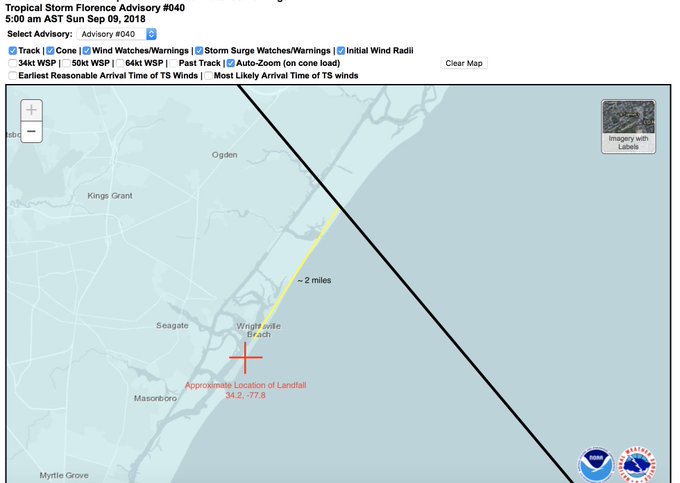
Retweeting this because it could get lost in all the coverage. The first NHC forecast for landfall was Sunday morning at the 500 AM advisory. That forecast was only 2 miles off. Let that sink in for a moment....

This is incredible. The first forecast from
@NHC_Atlantic
that had
#Florence
making landfall was Advisory
#40
on Sunday morning at 5AM. This 5 day forecast was around 2 miles away from the actual point of landfall this morning. Amazing accuracy.
38
569
2K
1
16
41
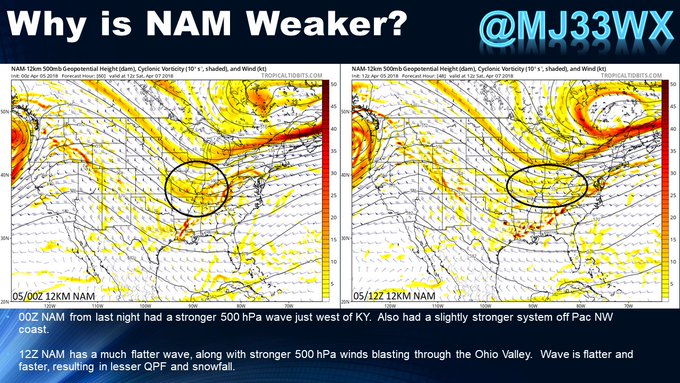
This map is from
@JackSillin
. This is comparing the 12Z observed 500 mb heights to the 00Z forecast for 12 hours later. Two things of note. The ridge out west is stronger than the GFS thinks, and the SE Canadian upper low is deeper. (1/n)
#kywx
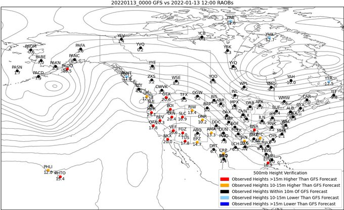
4
7
23

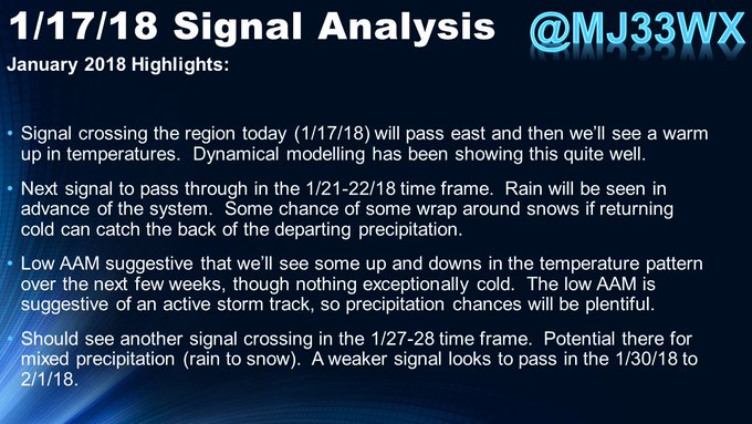
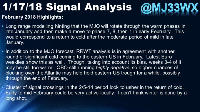
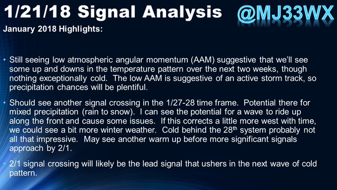
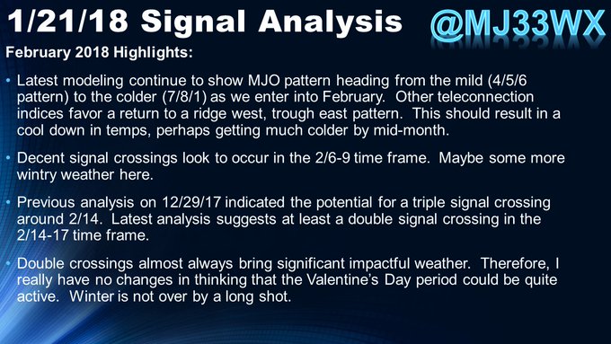
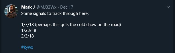
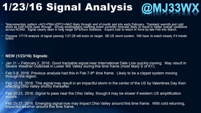
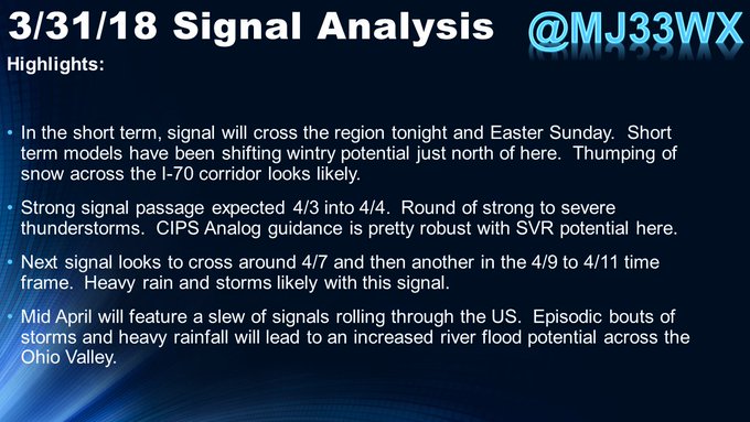
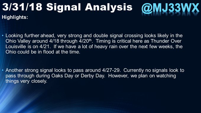
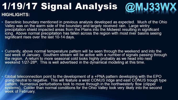
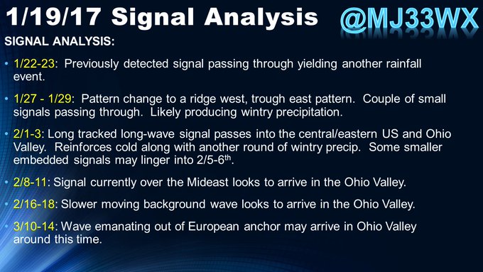
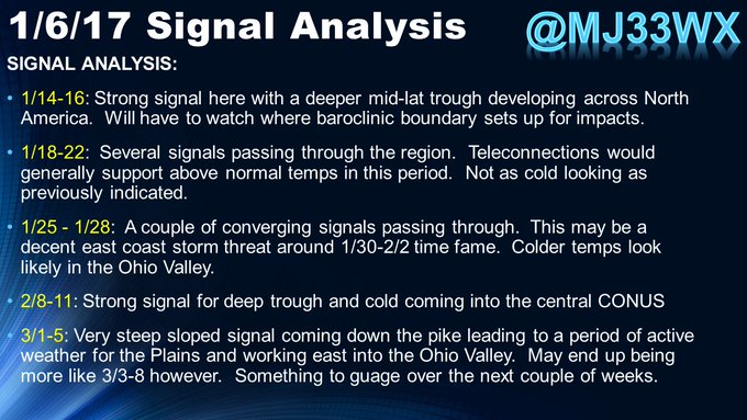
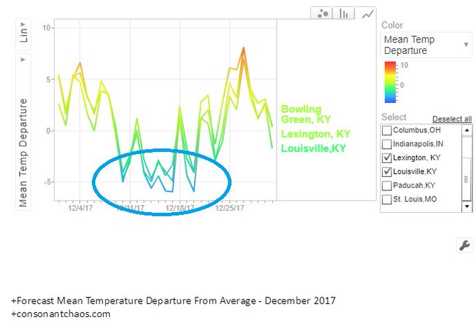
A couple of quick signals I'm watching:
12/14 (already in the dynamical models)
12/17-21 (may be one or two separates)
12/25 (strong signal and matches BSR progs). See
@crankywxguy
earlier post.
12/31 (strong signal as well).
#kywx
2
1
19


1
1
14
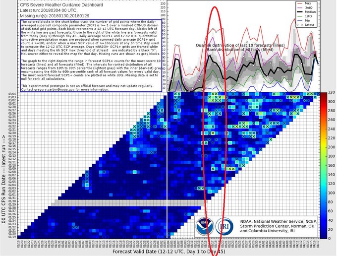
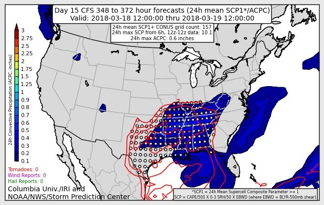
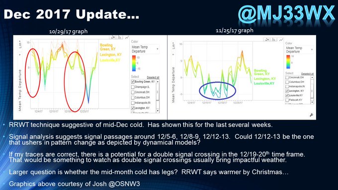
Not bad for a 13 day forecast. Not a lot of details at 13-14 days out, but there is some value here in that an area can be identified in general terms.
#kywx
1
0
13
I always find it interesting when Mets start preaching about forecast accountibility and transparency. Especially the ones that go through a delete prior forecast tweets that eventually did not pan out.
5
1
13
The Charlatan Forecaster...
Just put out a forecast and if it happens , you can claim to be right. If it doesn’t, people tend to forget. No downside either because you are a genius or people forget what you said.
Only thing...the internet never forgets...
2
1
12
So, I went to the theater and this is the first one where I could reserve actual seats. Wanting to sit in the middle and midway up, we ended in Row F seats F4 and F5. How appropriate.
0
0
12
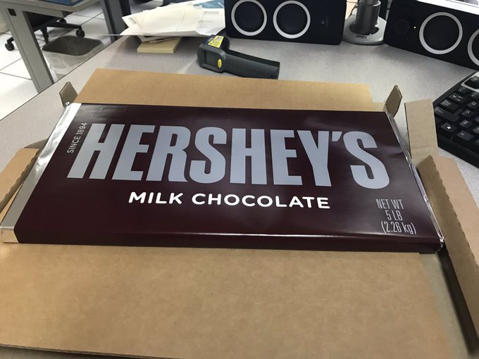
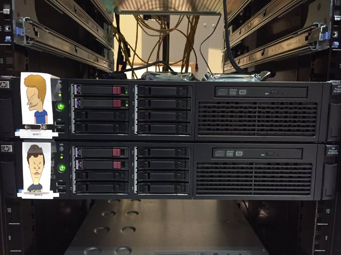
It’s one thing to volunteer at the NWS office. It’s another when you bring the office a 5lb Hershey Bar. Thanks
@CJ_Padgett
.
#kywx
3
1
12
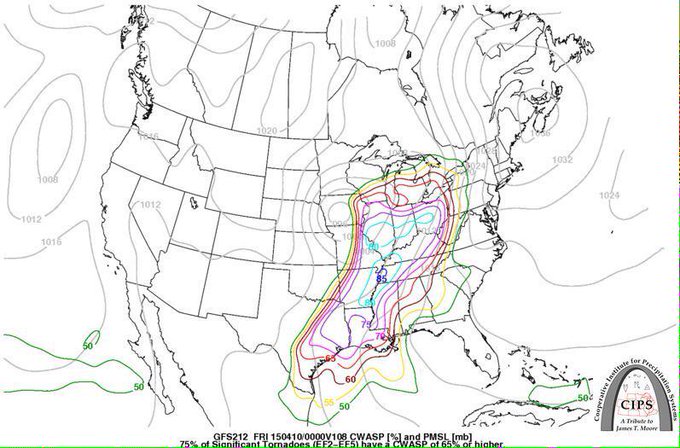
CIPS analogs for Thursday night based on the GFS. Not good, not good at all.
#kywx
http://t.co/z7OgQUkU25
6
16
11
So what happened last night with the snow? We did have evaporative cooling (wetbulbing) and the models handled that well. However, as you can see below, the models understimated low-level warmth in the lowest 2km. Left HRRR 18Z Friday, right 00Z HRRR which captured it.
#kywx

4
4
11
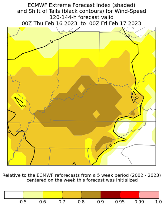
@webberweather
Yeah, so here is the latest EFI from the Euro for IA. First, the red shading here shows the EFI of 0.9-0.95. EFI values aboe 0.8 signal a very unusual event is likely. Shift of tails is 1-2, which means an increasing likelihood of an extreme event.

3
5
11
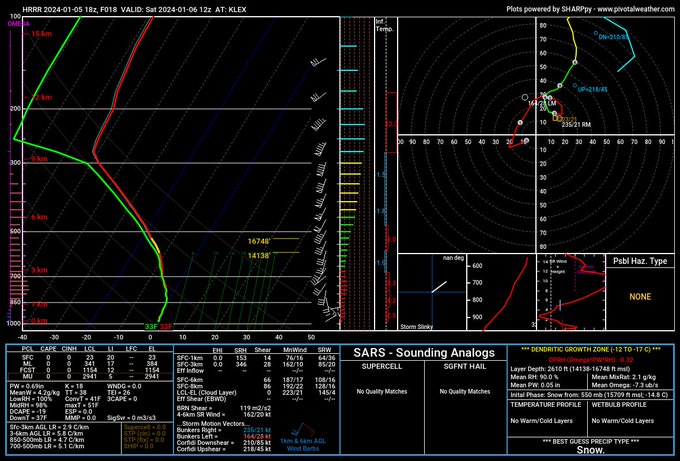
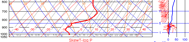
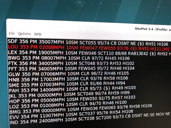
Just a note, ACARS soundings coming out of Louisville show a warm nose aloft. HRRR 18Z run completely misses this. Impact? Slower transition over to snow especially south of I-64….
3
2
10
This was true early in my NWS career. Sadly within the last few years, I have been told by some in my markets that we are their competition...

Broadcast and operational meteorologists are partners. Each has the same motive — keep the public safe — and we rely on each other equally; one is not above another. If you demean the other, you’re doing it wrong.
3
37
269
2
0
10
Please enlighten me...how can you say that you nailed the forecast, when this event is just starting?
2
1
9
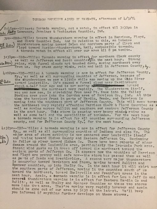
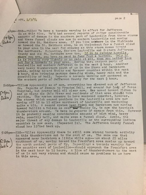
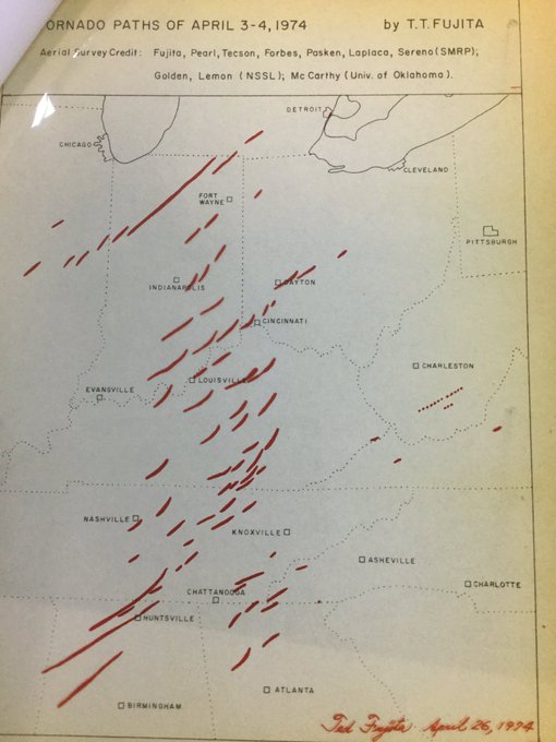
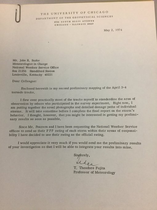
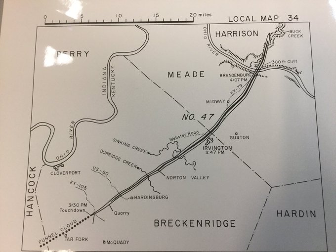
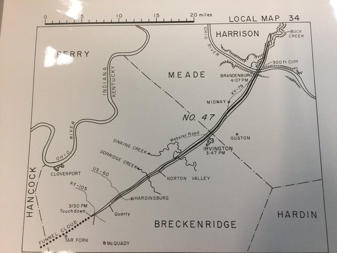
Just a very small sampling of
@NWSLouisville
’s Fujita maps of the 1974 Super Outbreak. Glad to have found this treasure box.
#kywx
#MrTornadoPBS
1
0
10
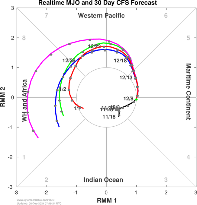
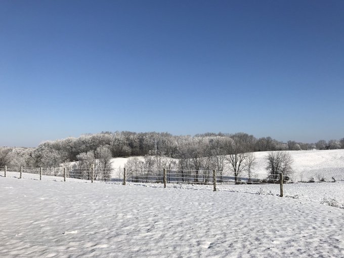
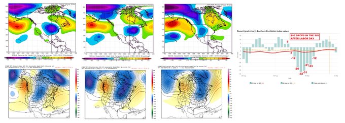
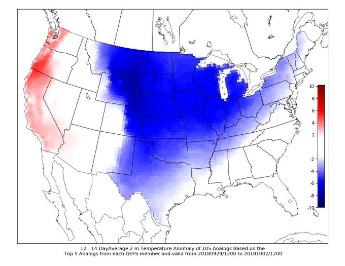
Another technique here that helps us see the pattern further out. Stronger trough at end of the month could give us a shot of frost before October...
#kywx

Sharp drops in the SOI (southern oscillation index) after Labor Day via
@KOPNFMRADIOWX
portend to our longest/sharpest cool down by the end of September. EURO ensembles picking up on this idea. 50s for highs around the Great Lakes perhaps? Rebound likely thereafter
2
2
12
0
1
8
2
1
7


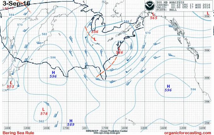
Well...at least the pattern looks interesting toward the end of the month.
#BSR
#organicforecasting
#kywx
2
0
7