

Noah Bergren
@NbergWX
Followers
45K
Following
56K
Media
11K
Statuses
33K
Weeknight Senior Meteorologist @FOX35Orlando. On air M-F from 5-7, 10-11:30 in Central Florida. Previously in Paducah, KY. Proud Penn State alum. CT native.
Joined June 2012
We were on the air for over 5 hours continually and this undoubtedly was and will forever be one of the most horrifying radar images we have seen. This was an upper-tier tornado of which has produced extreme damage and deaths across three states.


76
344
2K
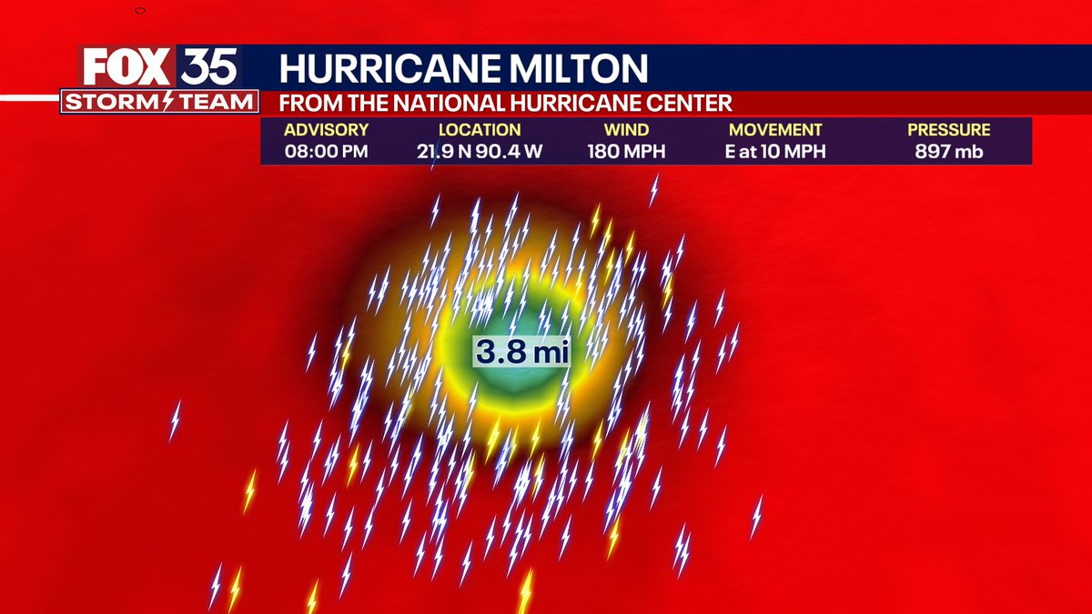
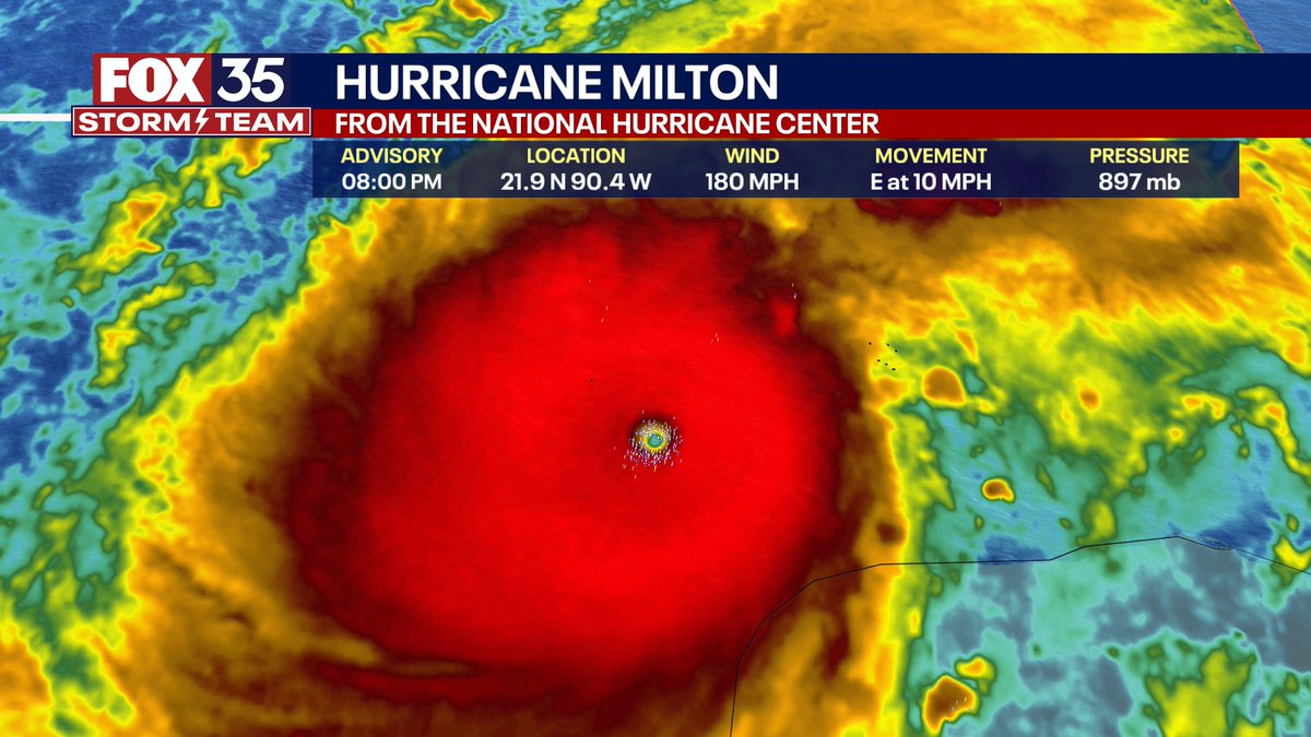
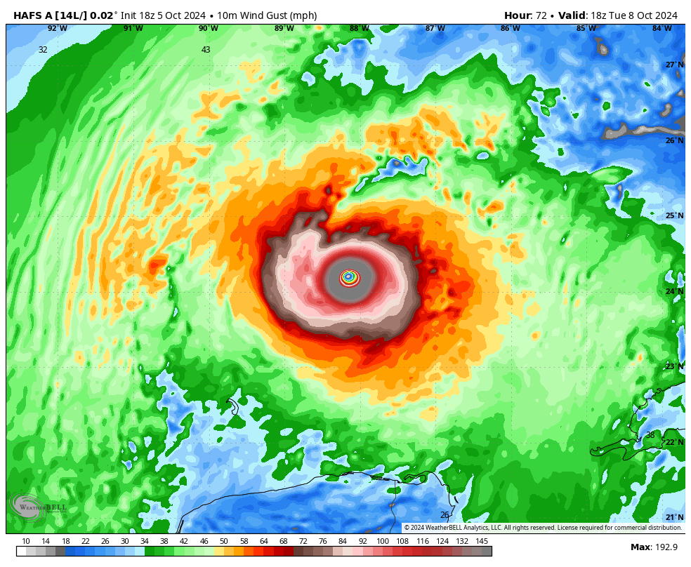
8PM EDT: This is nothing short of astronomical. I am at a loss for words to meteorologically describe you the storms small eye and intensity. 897mb pressure with 180 MPH max sustained winds and gusts 200+ MPH. This is now the 4th strongest hurricane ever recorded by pressure on
4K
38K
216K
Remarkable artwork from the lord above here. Rare “fire and ice” on Pensacola Beach, FL today!. 📸: Dan Dunn

418
4K
39K
This is getting really bad. Preparations should be underway for all of central Florida. Expect mandatory evacuations to begin probably Sunday at some point on the west coast. If this parallels I-4, this is one of the costliest hurricanes in Florida history. Track is key though.


455
3K
14K
HELENE will be a MAJOR impact well inland. Georgia, the western Carolina's, Tennessee and Kentucky! This is actually a rare meteorological setup for this side of the world. This is called the "Fujiwara Effect" -- notice how major hurricane Helene gets boomeranged NW and around a
243
3K
10K
Just insane that a single supercell has caused several different tornadoes and destructive hail over a 500+ mile path that lasted nearly 10 hours Friday night. Truly very uncommon.
156
1K
8K
Aurora viewing tonight. incredibly far south yet again! Some reports in the Bahamas already visible.

149
754
7K
MORE SUNSHINE! Daylight increases substantially during February. over an hour more for nearly half the country! Good for the mind, body, & soul.

86
872
7K
Meanwhile in New Hampshire….Peak gust 120 MPH & wind chill -1°F. winter is coming…

107
519
6K
St Armand's Circle in Sarasota, Florida late Tuesday evening. MAJOR rains fell with significant flooding ongoing there and Bradenton. Rain is over 10.3" just from Tuesday officially in Sarasota. In fact, 3.93" of rain fell from 7-8PM EDT Tuesday, which is the most ever observed
335
1K
6K
Not exaggerating when I say that in all of the years I have been forecasting and following weather. that this may be in the top-10 easily for most wild outputs I have ever seen from the European computer model.

262
863
5K
HURRICANE MILTON: This is shaping up to be a very rare path. There is a good meteorological reason for it due to the jet stream pattern next week (it has happened before, but very limited). A landfall in Florida is a certainty next Wednesday. Notice the range out outcomes. Each


112
1K
5K
With all this talk of New York and New Jersey earthquakes seemed like a good time to remind y’all about the real beast that has laid quietly in the eastern United States. If you are new to following me, do some research on the New Madrid fault line. Would be incredible far

331
1K
5K
Meteorologically this is a heck of a forecast. We all know in the weather-world that hurricanes "talk to each other" and influence one way or the other. Well, the hurricane models are trying to blow up "Margot" in a strong hurricane too. Depending on what that does, I feel
252
915
5K
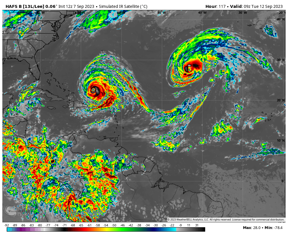
Updated HAFS-B model has been incredibly consistent with an absolutely remarkable intensification. Hurricane #Lee probably reaches into Category 5 this weekend. If taken verbatim (it is a model after all) -- has sustained winds possibly nearing 180 MPH. This is seriously extreme
194
1K
5K
As crazy as it sounds this thing may go from a tropical storm to a Cat 4 hurricane in 2 days time. Milton is SO small and already tightly wound that I think the hurricane models showing extreme intensification (barring eye wall replacement cycles) is not unreasonable on MON-TUES.


140
1K
5K
WOW! What a storm on visible satellite from GOES-17. Pressure nearing 970mb equivalent of a Category 2 hurricane. This storm is thousands of miles wide. Will produce the severe storms tonight in the PNW. A meteorological marvel from space. A perfect Fibonacci spiral.
200
807
5K
The #PalisadesFire is absolutely exploding in West LA and is quickly moving toward homes in Pacific Palisades. The images just continue to get worse. Sadly, the weather for Wednesday calls for even worse winds gusting 60-90 MPH in the Santa Ana Mountains. Evacuate if you are in
80
789
3K
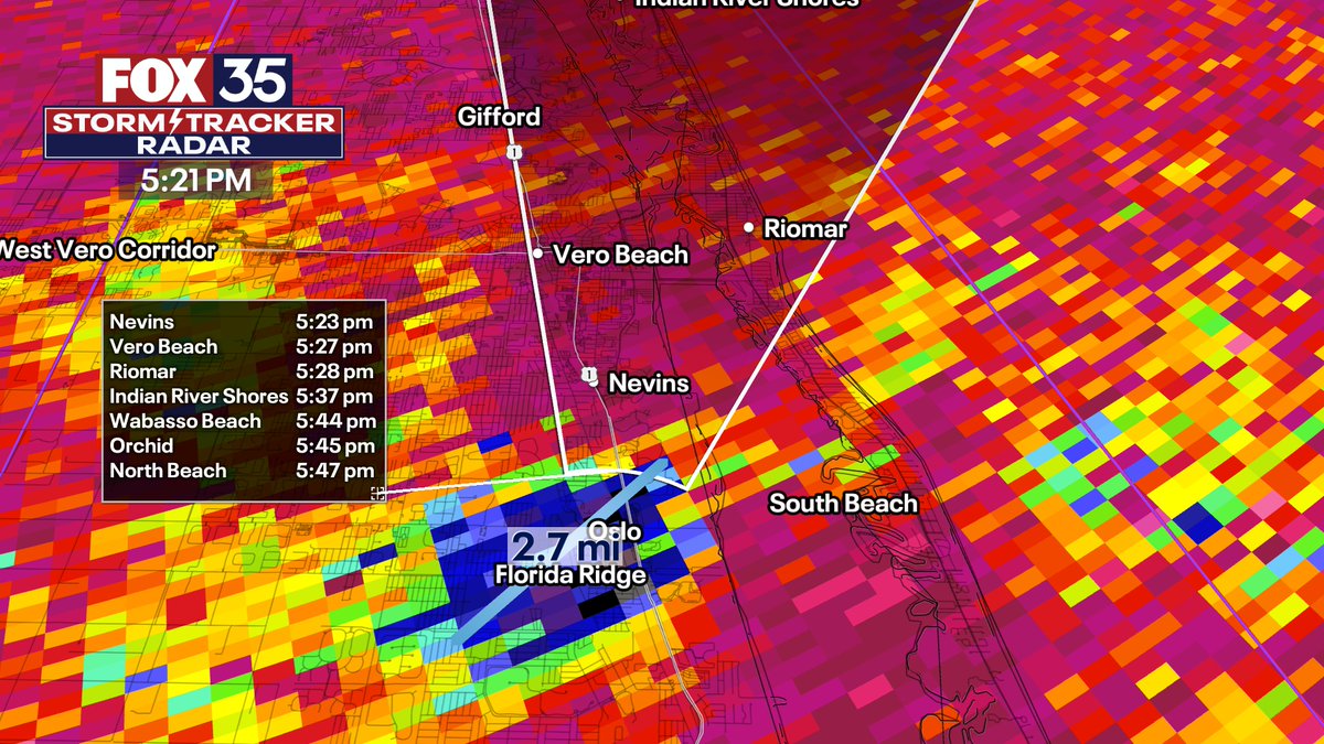
5:21PM EDT: **CATASTROPHIC TORNADO** in the Vero Beach, FL area. This is a rare tornado for Florida. This is a large, destructive tornado. Get to immediate shelter and cover your head in Nevins, Riomar, eastern Vero Beach IMMEDIATELY. Debris ball 2+ miles wide.
32
760
4K
Tonight will probably go down as one of the most prolific QLCS tornado producing events in Chicago recorded weather history. This may end up being classified a derecho. NWS Chicago Issued 16+ Tornado Warnings this evening, their most in a single day since April 20th, 2004, and

55
714
4K
HURRICANE BERYL: Basically unheard of for this early in the year. Will be a major hurricane by Monday. From there, we need to watch close into 4th of July weekend. Here are the hot off the press European model ensembles. Each line a model. I think we can confidently say *Florida

162
967
4K
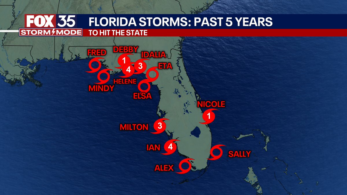
Been a heck of a 5-year spell of landfalls on the west coast of Florida.
100
506
4K
TONIGHT: In some lighter news to share, a G4 geomagnetic storm is impacting Earth starting NOW. Almost as visible as the massive solar storm earlier in the year. From 10PM to 4AM in your local time zone, aurora and northern lights visible with a camera in the yellow, and visible,

132
764
4K
The pretty new HAFS hurricane model has done great so far with #Lee, maybe a tad even underdoing it. It still tries to make it one of the strongest hurricanes ever documented on this side of the world tomorrow. By Friday midday, it brings the sustained winds to a ludicrous

114
569
4K
PERSPECTIVE: Been clamoring this on air, yes the Category will come down but let's focus more on IMPACT at this point. It is deceiving. Katrina and Wilma did this too a 5-4-3 and were very major impacts. It could hit as a 3 or a 4 no idea which. But, the wind field will expand


44
583
3K
7:53PM: This supercell producing a major violent tornado has INSANE structure. KFOR chopper just captured this visual. Very violent tornado about to pass right over I-35 in the Norman area.

68
848
3K
Dust to the left, dust to the right, there in the middle, Beryl, a benchmark storm.
47
673
3K
8PM EDT: Concern for a "sting jet" to develop on the backside of Milton has increased. We have talked on the air and here all week about the backside winds. Well I feel much stronger now the wind will be major impact in the I-4 corridor. A sting jet is when a tropical low

65
620
3K
JUST IN: As we talked about I had a bad feeling this was coming. Here we go folks. Tropical Depression #14 has formed and will become a strong hurricane MILTON. This could make a run at major hurricane status I think. This is a RARE track and hurricane. Why? Rare in the sense


68
625
3K
There is no sugar coating or toning down needed. But also no "hype" from this either. Wednesday this week is the "real deal" for a regional severe weather outbreak in the mid-Ohio to mid-Mississippi Valley. At this point I don't see how at a minimum the day of won't end up in at

170
549
2K

BREAKING: This is now a mass casualty event in western Kentucky. ‣ Deaths are possibly between 70-100 lives from this Mayfield tornado.‣ 181 national guardsmen are arriving in communities this morning.‣ Heavy equipment will be sent from state level.
79
876
2K
Yet another example of nature exhibiting mathematical obedience.

25
208
2K
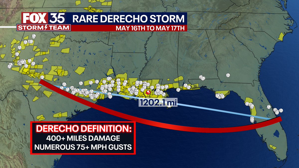
Some big weather news today, the historic severe storm that started in Texas and ended in central Florida Thursday evening into Friday midday has now been designated a "derecho" wind storm. Early damage estimates are several BILLION dollars just in Houston, Texas alone. It
55
611
2K
2:40PM EDT: #Milton undergoing another window of intensification. Should become a Category 5 again this evening. We will see how much deepening it does before shear kicks in tomorrow. Could it challenge last night's intensity? Do not know. But it has the "loop" current of the
35
301
2K
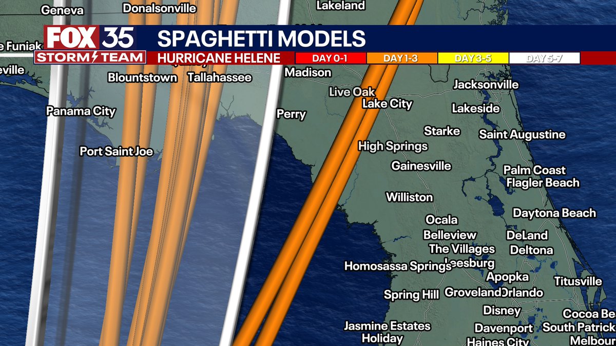
We need to keep close tabs with the track tomorrow for major Hurricane Helene. Some models, including the IBM, and the GFS modeling are consistently outside the "cone" and bring the eye of Helene closer to Cedar Key and the Lake City/Gainesville area. That would mean obviously
57
319
2K
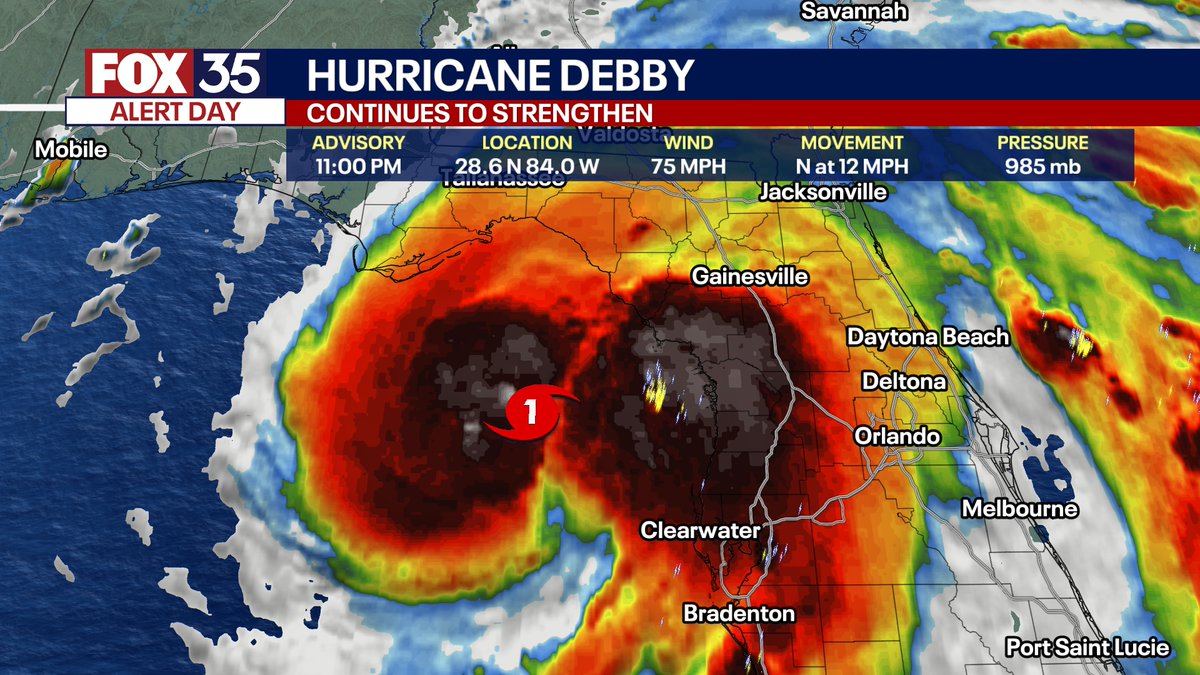
JUST IN: Debby is now a Category 1 hurricane, in one of the most peculiar satellite presentations I have seen in a hot minute.
117
464
2K
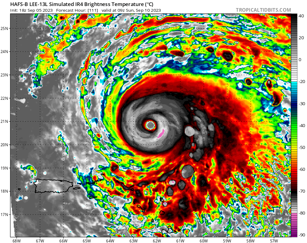
Take yourself on a fly-over and through of rare Hurricane #Lee tonight. the eye appears to be slowly shrinking. eye-wall replacement cycle could be coming soon. Most of where you see black on this image indicates cloud top temperatures at or below -100°F!. It never gets
38
252
2K
HISTORIC SNOW: Just one that will be talked about for a lifetime for many. New all time state record snowfall in Milton, FL for the Sunshine State. Shattering record in New Orleans with over 9" of snow. These numbers as of 12AM Wednesday.

39
444
2K
Our tropical FOX Model just updated, and is interesting for sure. Continues on the point that the Texas coastline to Louisiana should keep tabs closely with Hurricane Beryl. I think the most likely path at now would be more into far SE TX or NE Mexico, but there is clearly a wide
77
341
2K
Super Typhoon Kong-Rey is easily one of the largest eye's in a major tropical system you will ever see on Earth. Thing is absolutely massive.
34
551
2K
INCREDIBLE TWISTERS: Hurricane Beryl will be talked about for a long time by many for memorable tropical systems. Over 200 tornado warnings were issued from July 8th to 10th, the most since Hurricane Ivan in 2004! The strongest tornado so far occurred in the west KY/southern IN

13
408
2K
Complete pattern flip for February. Much more La Nina like. Warm, possibly very warm in Florida and the southeast. Dry too. Severe storms/tornado chances from TX to TN and AR. Major cold and snow in the high plains and PNW.

67
243
2K
Incredible doesn't cut it. This truly is something else of a hurricane. Hurricane models have largely done great so far. Updated HAFS model indicates #Beryl could definitely get into the upper echelon of Category 4 by Monday morning, if not knock on the door of rare Category 5.


39
382
2K
WOW, this has gotten very bad very quick. A rare Flash Flood Emergency was just issued for North Miami to Hollywood, FL. Between 6 and 9" of rain has fallen in the past 5-6 hours, and up to 8" additional of rain may fall in the next few hours. That would be at maximum up to 17"

84
489
2K
One week away from likely another (and bigger) cold front into the United States. Very cold start to December ahead my friends.

25
148
2K
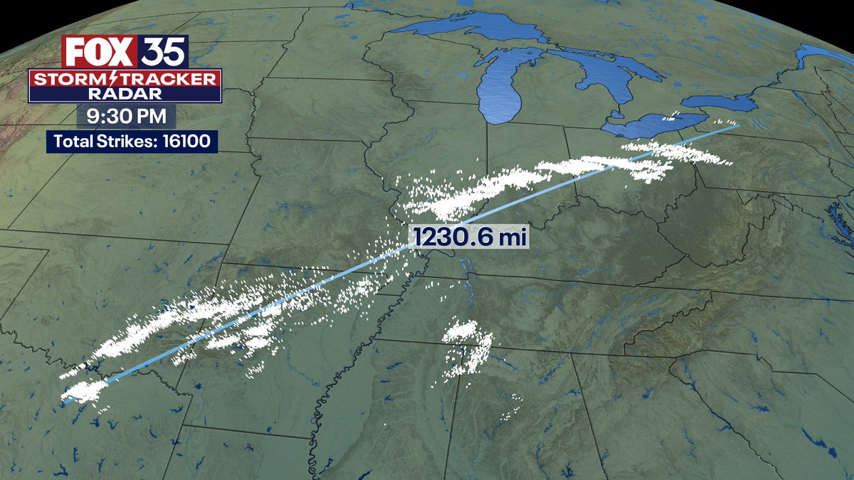
This is actually bizarre and I am not just saying that. This will be one of the more notable severe storm nights in March in recent memory. In the past hour, over 16,000 individual lightning bolts from western New York to NE Texas -- spanning over 1,200+ miles!
56
414
1K
We got this shot from a lake house on Lake Barkley… we just down from Boyd’s Landing. The tornado was tracking across the lakes at this time. Absolutely remarkable shot.

6
383
1K
Seldom do you have a hurricane and blizzard warnings within view of each other on the same weather map.

17
234
1K
Want to make something else clear -- #Lee will reach extreme intensity tomorrow. But, it will *not* be at that intensity forever. Should go back and forth between Cat. 4 and 5 this weekend. Then once it turns north it will gradually weaken, but still be a strong hurricane. These

38
149
1K
NEW overnight: The Storm Prediction Center's latest severe outlook now has a rare, Level 5 out of 5 risk of severe weather in the Deep South later today. This is the first HIGH risk issued from SPC since May 20th, 2019. The last HIGH risk in the month of March was in 2012.

75
575
1K
I do not share these words without significant thought beforehand. I do NOT like how tonight is trending. Data is converging on there being some lone, large supercells blossoming rapidly ahead of the 'main line' of storms. These are extremely concerning to me. The parameters at


25
319
1K
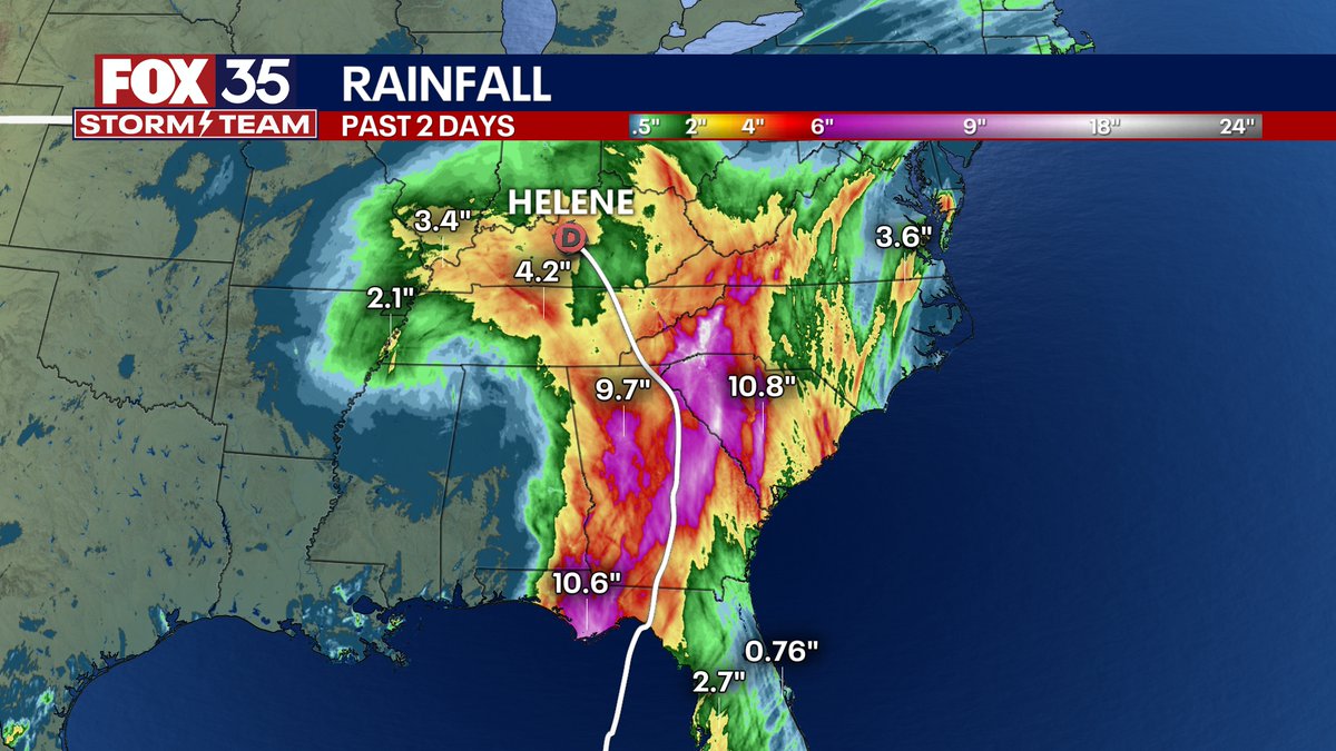
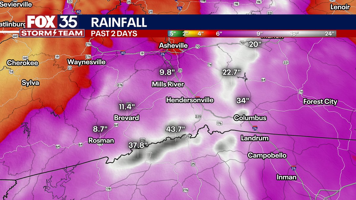
EXTREME and some have called generational flood in the mountains of North and South Carolina. Georgia got hit bad too from flooding today. 40"+ of rain fell in spots (second image) with this highly unusual Fujiwara-induced track NW of a hurricane remnant. That unusual track

28
262
1K
Crazy day for tornadoes in central and south Florida. Nearly as many tornado warnings as occurred in Alabama during the super outbreak of 2011 on April 27th. Sadly, turned deadly.

27
267
1K
Stop me if you have heard this before in 2024. Hurricane #Rafael is quickly re-strengthening tonight over very warm water and low wind shear. Look at the convective burst on the west side of the center. Will become a Cat. 3 or 4 hurricane in the southern Gulf next few days.
48
244
1K
in Lake Mary, Florida. About 4 mins from our TV station on Blue Iris Place. Two homes nearly leveled, about 6 with major damage. Path appears at least 1/2 a mile. @fox35orlando


39
340
1K
To say the tornado ingredients are off the charts for Saturday evening in Oklahoma and southern Kansas is an understatement. top-end tornadoes are possible with hail sizes maxed out!

16
306
1K

Crazy. Stronger than Ian.Faster than Charley.Nearly 2.5x the size of Ian


10
178
1K
WOW -- The Australian Bureau of Meteorology reports a storm Tuesday north of Mackay may have produced the largest hail ever in Australia. It was estimated at 16 cm (6.3 inches) in diameter. which would mean it fell at a terminal velocity of well over 100 km/hr (62.13 MPH)!


44
382
1K
It’s becoming clearer by the hour that given ample fuel from elevated sea surface temps. and lighter mid-upper level wind shear, that #Idalia could strengthen all the way up to landfall. As others have discussed, once the center gets into the Gulf tomorrow, how quickly it gathers

21
128
1K
Sweet shot of this morning's shelf cloud rolling into western Kentucky!. 📷: John Goodwin | Trigg County, KY

15
145
1K
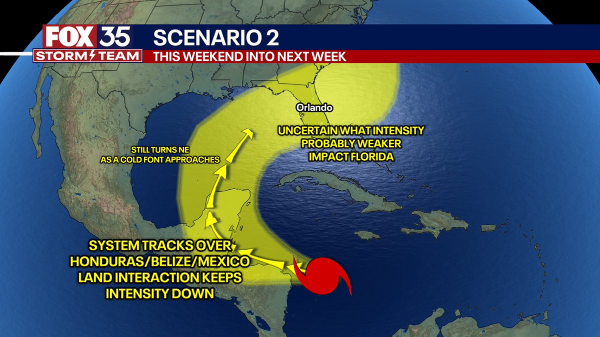
SARA SCENARIOS: Door #1 could likely become a high-end hurricane when in the Caribbean if avoids land interaction. Meanders some this weekend then lifts towards the FL Peninsula mid-next week. Could be be central or north-central FL? I guess, but that would be unprecedented. I'd

32
230
1K
6:15PM CDT: Wow! What a LIVE shot. This from FOX Chicago. ORD airport radar is detecting strengthening rotation just ~2.5 miles south of O'Hare International Airport!

16
301
1K
The center/eye of hurricane #Milton may come right over the Orlando area early Thursday morning. Think our model is on the right track with winds being strongest on the 'back side' in the NW flow. Winds peak everywhere in central FL with 70-100 MPH gusts seems like a good bet at


19
218
1K
It's so early in the game but one thing is clear other than that #Lee becomes an intense hurricane. that everyone from the Carolina coast to New England (and Bermuda) needs to follow the forecast closely. Anyone calling it a total 'fish storm' now is incorrect. Way too soon to
20
161
941
JUST IN: Helene now an extremely dangerous Category 4 hurricane. I think it is going to try and make a run at Category 5 which is 157+ MPH sustained winds. Whether it does or not, this storm will intensify all the way to landfall. Look how large the eye has gotten.

8
170
967
Global computer models today generally took future tropical system #Sara towards the Yucatán Peninsula this weekend then try and hook it NE towards the Florida Peninsula next week. We will update daily how these trend. Remember, no spaghetti models yet until the NHC declares the

34
171
985
This will be in a textbook someday. Supercell had a major tornado, deviant motion then hooked hard to the north, then split into two, may have briefly produced 2 concurrent tornadoes, now the southern circulation is becoming dominant as the northern, original tornado occludes.
11
204
935
Simply put there appears to be two clear scenarios later next week for our hypothetical tropical system forming between and Cuba. A stronger, farther south cold front over the central-eastern U.S. probably pushes said system into Florida, possibly a tad faster with less time to


28
163
898
We are now in range of the hurricane models' opening bid for #Lee and its possible New England impacts. Interesting to note 1st that both HAFS models are showing the storm not getting swept by with the trough. and slows down (uncommon for Northeast tropical systems) and even
31
137
781
Quite the satellite loop the past 24 hours. Tornadoes from Pittsburgh to Michigan to Alabama to Kentucky to Illinois to Missouri to Oklahoma to Georgia. Just endless convection in the atmosphere in the eastern U.S.
24
151
799
TROPICAL SCENARIOS: Listen, the model and pattern data is very convincing -- meaning that there is a high confidence this system is not a "fantasy" in the data and is credible. In short there appears to be two camps of outcomes. Scenario 1: Potential #Sara gets forced northward


24
137
825
Pretty rare comparison and crossover here. All hurricanes that hit the United States in the 2024 season. most of those areas will now see a major snowfall this week. Many of these same places saw strong tornadoes, flash flooding, and storm surge just a few months ago.

15
176
835
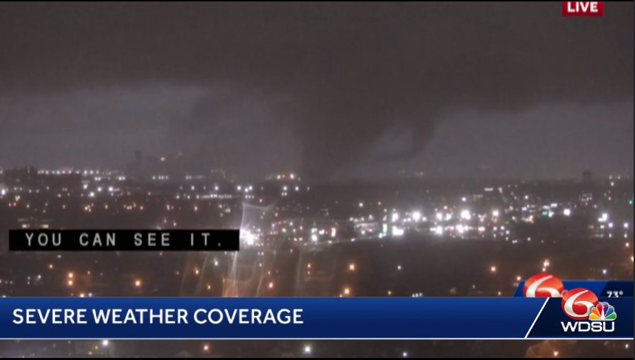
Heartbreaking. goodness this is terrible radar data. A Tornado Emergency is in effect in southern Illinois, the rarest weather alert in the United States. 1+ mile debris ball, this is an ongoing strong EF2+ tornado. Tracking right towards Carrier Mills, IL and Harrisburg, IL.


16
237
828
MILTON: Let's watch this one over the weekend closely. This *could* be a very impactful storm. Couple of thoughts. RAIN: there will be two waves. Monday and Tuesday ahead of Milton -- lots of slow moving downpours and storms that could saturate the ground. Some flooding could

23
165
747
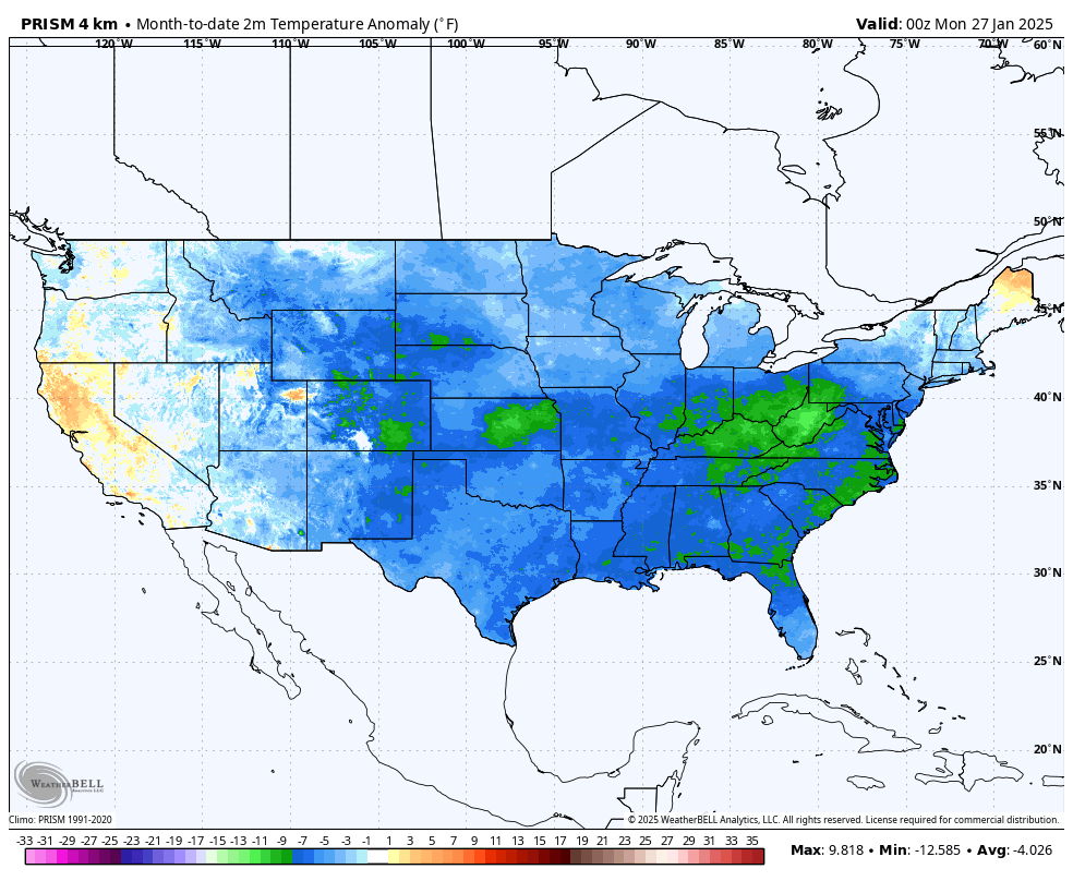
January 2025 currently the coldest January since 1988 averaged across all of America. Greatest cold anomaly below average. West Virginia and Kentucky.
30
119
787
Somewhere theres group of aviation meteorologists at one of the airlines that frequents LAX-NYC “rooting” for this jet stream pattern to verify. Even not being an aviation meteorologist, I know this would have to produce one of the fastest cross country flights you’ll ever get.

28
91
707

This is from north Nashville, along Nesbitt Lane. This damaged caused from what became the Hendersonville, TN tornado. Just so disheartening to see this anywhere in the U.S. -- let alone this region again. Just two weeks before Christmas yet. I am getting flashbacks just typing

20
159
704

WOW! Over a 110 degree contrast from North Dakota to Florida today. I must say, it is quite early in the year to be this hot in Orlando. Where would you rather be?

31
96
759
11PM EDT advisory: pressure weakened slightly. Eyewall changes and land interaction. Potential it could undergo another window of intensification Tuesday. Some models show that. But lets focus on landfall. Miles matter for the surge in Tampa. Along and south of the eye/center


22
107
670
Our 18z latest IBM GRAF model came in a tad SE of other models with #Idalia landfall. There *will be* devastating storm surge along and SE of the eye. Question for the Tampa/St. Pete area is where does the eye go. these small track details will mean *huge* swings in surge
16
136
658
Chances are growing for another potential tropical system in the Gulf late next week -- could become a hurricane.

18
128
656
This is the quietest I have ever seen this camera. Not a single car on I-4 around Orlando.

6
51
658
WOW! Large wedge tornado ongoing NOW in Lake City, Arkansas. This storm is tracking towards west KY. LIVE from FOX Weather stream.


10
144
700
Man it is REALLY starting to whip in downtown Orlando. Hurricane force gusts have arrived big time.
7
75
646
We have people trapped at a Candle Factory in Mayfield. And houses either destroyed to the foundation and others with significant damage. Main Street in Mayfield has taken a direct hit.
27
354
631
One trend of several I am seeing tonight is the potential for LONGER impacts in central FL well into Thursday. Also stronger winds on the "back" side relative to the front for Orlando-Daytona corridor. As the hurricane interacts more with the jet stream, the wind field on the

15
125
639
About a dozen of the ECMWF ensembles today suggest still Hurricane #Beryl may make more of a significant NE turn this coming weekend into TX or LA. Personally think this remains unlikely but definitely should not discount it yet. All comes down to the high pressure placement.

31
136
663
As we head forward, we will have to keep close tabs on this tropical wave. Not a lock by any means it develops yet. Here is the approx. timing if it became something. If it threatened FL, the Gulf Coast, or SE United States it would be September 7th or after. @fox35orlando

34
107
654