Erin Yost
@ErinWx
Followers
914
Following
4K
Media
9K
Statuses
18K
MTN Meteorologist. MT mama by way of MN. MBA Montana Weathercaster of the Year in 2009, 2016 & 2018. Runner up in 2008, 2015 & 2017. FB: https://t.co/gabMq9VAyo
Missoula, MT
Joined July 2010

A front will bring gusty southwest to west winds 15 to to 25 mph with gusts to 35 mph, choppy waves 1 to 3 feet to area lakes, especially Flathead Lake between 11 am and 7 pm MDT Friday. #mtwx
0
3
3
A clipper-type weather system and cold front moving through the region Friday night will bring rain and snow showers with lowering snow levels and a shift to gusty northwest winds. #MTwx
0
1
1
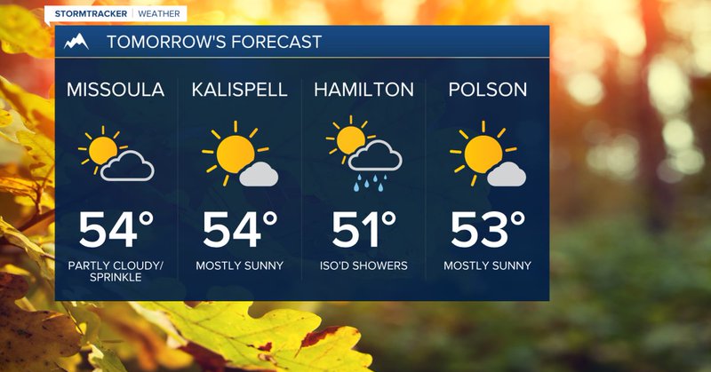
Friday will feature a few mountain snow and valley rain showers with near normal highs... the full forecast here: https://t.co/xcFQYozSfG
#mtwx #Montana #Missoula #Kalispell #Hamilton

kpax.com
We'll see breezy conditions Friday with a northwesterly flow ushering in a few mountain snow and valley rain showers. Highs will be around average in the mid 50s.
0
0
0
Atmospheric river event favors increased chances of stormy weather over the Western U.S. during late October
7
46
299
Persistent low clouds & stratus remain stuck in the valleys today, keeping high temperatures suppressed in the 40s. Where we saw some sun, temps climbed into the 50s. Expect these clouds to hang around until a system brings wind to mix out the inversion by mid-day tomorrow. #MTwx
0
2
7
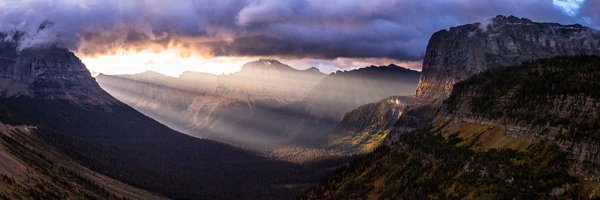
Love this shot taken earlier Tuesday near St. Ignatius... #fall & #winter battling it out! #mtwx #Montana #MissionValley #MissionMountains #StIgnatius #autumn
0
0
1

🚫 An alert from @GlacierNPS states the road is now closed between Avalanche and Logan Pass. 🚫 https://t.co/J4xwxrCzS3
#mtwx #Montana #mttravel #gnp

kpax.com
The iconic Going-to-the-Sun Road in Glacier National Park is now closed for the season between Avalanche and Logan Pass.
0
0
1
Nothing major, but we'll see a couple chances for light mountain snow & valley rain midweek for mainly southwest #Montana... the full #forecast here: https://t.co/ZbleP1SuEs
#mtwx
kpax.com
The weather pattern will remain unsettled into the middle of the week as a low pressure system develops to the south with minor impacts to Southwest Montana.
0
0
1
11:30AM: Snow showers will periodically reduce visibility and create slick conditions along I-90 from #Deerlodge to #HomestakePass through the afternoon. Light to moderate snow will return to SW MT Wed morning. #MTwx
0
3
13
Another round of light snowfall looks to move into southwest #Montana tonight and early Tuesday. Minor impacts from Salmon, ID to Lost Trail Pass & #Butte to Georgetown Lake are possible. The forecast: https://t.co/UxT3KCnxkd
#mtwx #mttravel

kpax.com
Another round of light snowfall will move into mainly southwest Montana tonight and early Tuesday. Expect minor impacts from Salmon to Lost Trail Pass & Butte to Georgetown Lake.
0
0
0
Winter Weather Highlights continue until noon Monday for widespread mountain and valley rain/snow (some lower elevations picking up their first measurable snow of the season)! The forecast: https://t.co/5i75CBxlWJ
#mtwx #Montana

kpax.com
Widespread & significant impacts are expected from Sunday night through Monday AM. A period of steadier, accumulating snow will create winter travel conditions in the high terrain & even some valleys.
0
0
0

0
0
1
High Wind Warning (9pm Sun.-noon Mon.) in effect for primarily #FlatheadLake & eastern portions of #Flathead Valley including Ferndale, and Many Lakes north to Lake Blaine. NE to E winds 30-40mph w/ gusts up to 50mph. Damage, outages & difficult travel expected. #mtwx #Montana
0
0
0