
CyclOSM
@CyclOSMorg
Followers
595
Following
85
Media
25
Statuses
108
New #bicycle oriented #map render based on #OpenStreetMap data. Source code is #FOSS at https://t.co/JACiW1uXNJ.
Joined October 2019
Looking for a quick map comparison to see the differences of the #CyclOSM bicycle style? CyclOSM is now included in the tools of @geofabrik and @BBBikeWorld ! https://t.co/FR49fuflOY
https://t.co/ne8toqKO4N
0
17
29
Version 0.6 of #CyclOSM is now live, with : - faded secondary railway - New color background for commercial landuse - and fixes, see https://t.co/JNeGiNnejB
https://t.co/D9VAWF5gNq
1
7
23
Contour lines are now on #CyclOSM ! New version with also: - Render cycle track areas - Use lighter blue for bus/cycle lanes Other fixes can be found here: https://t.co/qQsbauSSoE
2
10
26

weeklyOSM issue 548 now available in *English* the news from the #openstreetmap #osm world https://t.co/OOETGXTGuF
0
9
8
Do you know this feature ? Wonder if you can take an aeroway or a ferry with your bicycle ? Check it's line, if it's blue, it's good.
1
4
9
Thanks everyone who contribute 🤓 The full list of the change log is here: https://t.co/IkAC5jrvSh
github.com
Fix an issue with routes with state=proposed not rendered. See #438. Remove motorways at low zoom level. See #447. Thinner cycle routes and easier to distinguish secondaries / railways at medium zo...
1
1
2
CyclOSM 0.4 is now live with: - cycle route name - give way for cyclist - mountain pass, rework peak & saddle - floor bicycle parking - bicycle services rendered as sub icons - more visible drinking water icon - better railway visibility at low zooms - cyclable sidewalk - a 🎁🎄
1
21
44
Last week we released a new version of CyclOSM - Leisure tracks for cycling - LCN routes tagged on ways - Tracks are green now - Rework protected areas border And many other improvements : https://t.co/9BxpOxAdkb Many thanks to the contributors.
1
7
9
CyclOSM Belgium map with very good relief and level curve lines ! 🤩

Semaine de la #mobilité! Nous présentons notre nouveau serveur de cartes #vélo avec Cyclosm adapté à la Belgique -> https://t.co/ctM8pneqMT
@osm_be @CyclOSMorg @GeoportailWal
0
0
3
Want to plan a cycle trip ? You can now use CyclOSM on : https://t.co/nbIc9qa9b5 and
0
4
8
CyclOSM is also impacted

We are aware that the standard map rendering on https://t.co/f6yZeTB2fF is not currently updating with new edits and are working to resolve the problem
0
1
2
Making foot color brown help us to have widder range of colors after cycle blue, making distinction more easier. Building style rules has been optimize, working on the style is now faster. Full change list :
github.com
Add blue arrows on designated roads. See #304. Fix missing wind turbines. See #267. Fix incorrect overloading of amenities tags, leading to some amenities not being shown. See windmills in #267 for...
0
3
3
New version 0.3.6 is now in production: - blue arrows on designated road - render guidepost and map for cyclists - rework path quality surfaces rendering add unknow surface - rework path/road colors, biggest change is foot color is now brown https://t.co/elP98VGZHE
1
8
16
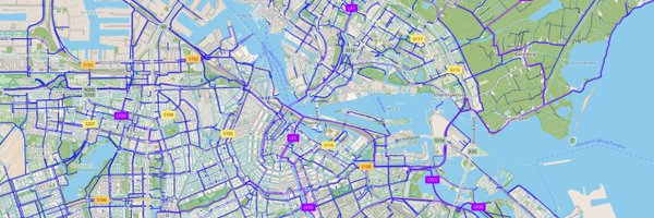
Is https://t.co/5I49BCuSmx the most accurate map of bicycle infrastructure out there? How does it cover your local area?
12
24
80

[CARTE 🚲🚧🚲] Vous préparez votre #Deconfinement à vélo ? On vous aide à trouver votre route avec @GrandParisMGP avec notre carte qui recense : ✅les #pistescyclablestemporaires réalisées et en projet ✅Les aménagements cyclables déjà existants https://t.co/zvYwp1ZdBz
25
105
172
Nouvelle version de @DryBike en beta avec les cartes de @OpenStreetMap @OSM_FR Merci à @CyclOSMorg Vous avez la possibilité de choisir plusieurs type de cartes : GoogleMap, Carte pour cyclistes, Carte pour randonneurs, Carte pour amoureux de la nature. Sorti finale le 10 mai
1
2
5
Hi cycle world, don't hesitate to add your #PopUpBikeLane to OpenStreeMap Do it as usual, here is the documentation https://t.co/MlXebnnYgI
@osmberlin @OpenStreetMapCo
1
1
5
- Render indoor paths like tunnel (faded). Full changeset https://t.co/VWhYBLj7P4… Low zoom tiles will need some time to be regenerated. As always feel free to comment what can be improved: more features ? more readable ?
1
0
3
New release (v0.3.5) with : - Render mountain bike scales - Render railway at low zooms (best to travel with a bike :) - Inner tube vending machine - Render glaciers, scrubs and spring - Improve density of city names in countryside at Z10/11 ... https://t.co/elP98VGZHE
1
12
17