
AlcisGeo
@AlcisGeo
Followers
3K
Following
789
Media
778
Statuses
2K
Improving the lives of the world's most vulnerable people through innovative, world class Geographic Information Services.
Joined September 2011
We're turning a new page in 2025 and it's come time for us to say goodbye to our platform on X. We're looking forward to a bluer sky in our future. See you on BlueSky 🛤️@alcisgeo.bsky.social Follow us on LinkedIn: https://t.co/SjHsKnovrG
https://t.co/LxfTAF10Zp
0
0
1
Today is the first-ever World Day for Glaciers! Today, we urge global action to protect glaciers & their crucial role in sustaining life on Earth for future generations. This new storymap from @AlcisGeo explores increasing risks in the Peruvian Andes. https://t.co/nVx631GmrK
storymaps.arcgis.com
Exploring the Threats of Glacier Retreat and Glacial Lake Outburst Floods (GLOFs) in the Cordillera Blanca, Tropical Andes
0
0
2
Thank you to @DAIGlobal for your message of congratulations! We've just released a blog article that expands more on the competition, and what it was like creating the #StoryMap. Read the blog here:
alcis.org
Delighted our StoryMap won the "Building Trust, Protection, and Ethics in Data" category at the 2024 UNWDF.

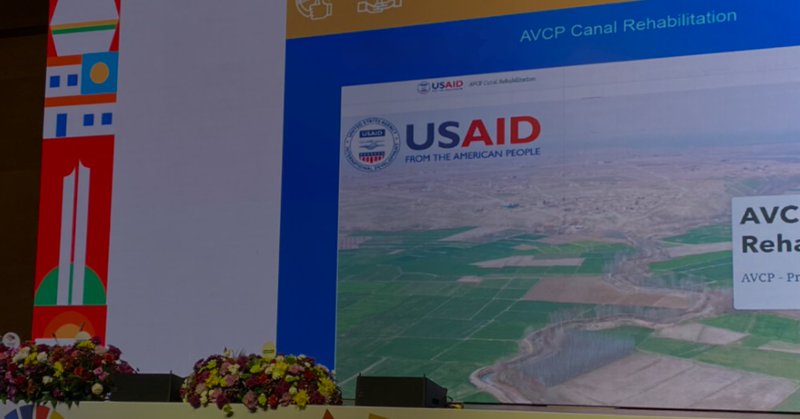
Congratulations to our partner @AlcisGeo for winning a @UNDataForum for co-creating a #StoryMap about a DAI-led project funded by @USAID #Afghanistan about a canal rehabilitation. https://t.co/hNJW8Nluef
@esri @USAIDAfgMD For more about the project: https://t.co/BKj5Xmxjhx
0
0
2
Take a read of @reliefweb's and @Connecting_biz's latest report on technological methods for disaster management. Using #GIS and #EO is crucial to understanding, preparing and recovering from the effects of disasters. Visit our disaster response page:
alcis.org
Geographic information is critical in the humanitarian response to disasters.
RT @reliefweb @Connecting_biz Innovation in Disaster Management: Leveraging Technology to Save More Lives Report https://t.co/CWRkiplRQh
@undp @unocha @preventionweb @undrr @iaem @nema_web @iascch @Insarag @ahacentre @eu_echo @VOSTeurope @LaurentAlfonso
0
2
4
It's great to see how @FAOKnowledge are using data to support disaster relief initiatives! When faced with natural disasters and/or humanitarian crises, the need for effective action is stronger than ever. Read our humanitarian response page:
alcis.org
Geographic information is critical in the humanitarian response to disasters.

🌍🚨 Leveraging data for action! @FAO's DIEM Hub uses timely, detailed data to guide relief efforts in diverse disasters, enhancing the response to agricultural shocks worldwide. Discover the power of data-driven disaster response 👉 https://t.co/CmXV4FmOXz
#ScienceDay
0
0
0
Are you headed to the Esri Federal #GIS Conference in Washington come February? Don't miss this fantastic opportunity to showcase your maps and potentially see them featured on the main stage! https://t.co/LxfTAF0t9R
alcis.org
Improving the lives of the world's most vulnerable people through innovative, world class Geographic Information Services.

Share your work with the national government community. Now is a great time to submit images of your operational dashboards, portals, hubs, and apps for potential use in the Plenary Session at the Esri Federal GIS Conference. https://t.co/z31pxkJxQh
#FedGIS2025
0
0
0
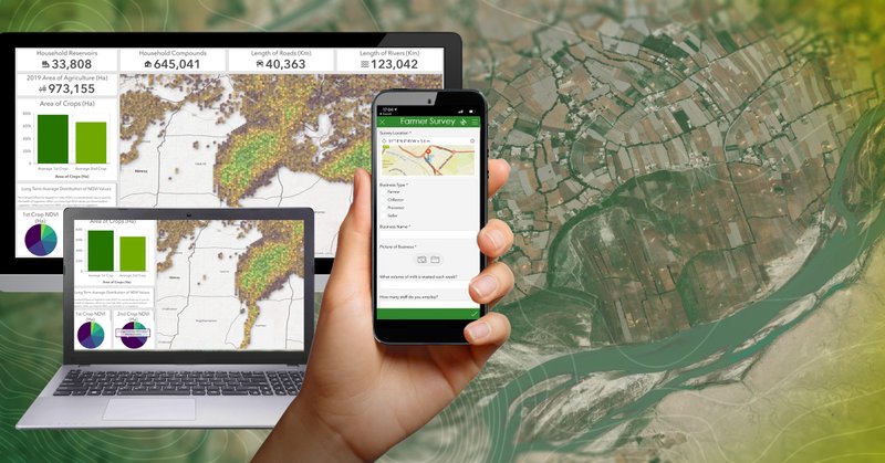
Understanding soil types is key to promoting quality agriculture and sustainable #foodsecurityforall. This remind us of our work in supporting @SeedsForDev's efforts towards food security in Uganda. Find the StoryMap called 'Satellites and Seeds' here:
alcis.org
We present our findings and analysis in many ways, including StoryMaps.

A Map🗺️ Showing Soil Types of Africa Continent , Dataset is from European Soil Data Centre (ESDAC) #Africa #EastAfrica #WestAfrica #SouthAfrica #NorthAfrica #Soil #Soiltype #geology #map #dataviz #gischat #geospatial #dataviz #qgis #b3d #Blender
0
0
2
With an increase use of AI in the #GIS industry, it's great to see how it used to assist in cases of natural disasters, like drought. While we aren't heavy AI users, our work in conflict areas often deals with natural and humanitarian disasters. For more:
alcis.org
Geographic information is critical in the humanitarian response to disasters.

ChatGPT but for maps.💡Here's a first look at our work on a Smart Mapping Assistant prototype that combines the power of GIS with generative AI. https://t.co/lykp8zvTGM
#AI #GIS
0
1
1
As we enter into 2025, its great to see developments in the #GIS world! In 2025, we want to make more StoryMaps to spread information creatively about conflict countries around the world. Check out our StoryMap page:
alcis.org
We present our findings and analysis in many ways, including StoryMaps.

Make your work shine in the new year! ✨ The Jan 2025 Issue of #StoryScape celebrates organizations that transform traditional end-of-year and related reports into engaging multimedia stories. And we offer #StoryMaps resources to help you do the same. https://t.co/KXffxpX3K7
0
0
2
We want to extend a very merry Christmas and happy holidays to all who celebrate. Our team is taking a well deserved break, but we will be back in the new year. We look forward to sharing some BLUE news with you soon!
0
1
1
Here is another opportunity to expand your #GIS skills and techniques. 🗺️ Sign up for the GeoTech talks through the link below to keep up to date on the latest esri developments! https://t.co/LxfTAF10Zp
alcis.org
Improving the lives of the world's most vulnerable people through innovative, world class Geographic Information Services.

Learning Resource Spotlight 🔎 Stay up-to-date on the latest in #geospatial tech by subscribing to the "GeoTech Talks" channel 👉 https://t.co/6xdRFU1KGo . #Geotalks offers hands-on tutorials, real-world applications, and new tools and trends 📊
0
1
1
Its great to see how others are spreading the word of how impressive #GIS can be for peacekeeping initiatives. #OSM and crowdsourced data are two brilliant sources of knowledge under the umbrella of geospatial technology! https://t.co/tu6IJ8pn2X
alcis.org
Improving the lives of the world's most vulnerable people through innovative, world class Geographic Information Services.

🇦🇹 Vienna, Austria Presenting "UN Maps: How Open Geospatial Information Supports UN Peacekeeping" to students at Central European University. We showcased how #OSM and crowdsourced data drive collaboration&innovation in humanitarian aid&peacekeeping🗺️ 👉 https://t.co/ar2dOfCUUg
0
0
0
Despite being primarily a messaging app, WhatsApp has a variety of other features - like instant mapping 🗺️ It's great to see how others are leveraging technologies to help in disaster situations. Check out our humanitarian response page:
alcis.org
Geographic information is critical in the humanitarian response to disasters.

🚨💬 ChatMap, the new tool from HOT, transforms @WhatsApp chats into instant maps 🗺️. It extracts location data and messages—perfect for communities in disaster-prone areas. It even works offline! Explore and map! 👉 https://t.co/GFBcPvZdnH
0
0
1
The Taliban's opium ban has led to a 67% drop in poppy cultivation areas in 2024, reshaping Afghanistan's economic and social landscape🌹 Read more in William Byrd's article: Understanding the Implications of the Taliban’s Opium Ban in Afghanistan.

A great article by Bill Byrd @USIP, drawing on reporting by @mansfieldintinc & @AlcisGeo on the risks & impacts of the #Taliban’s drugs ban in #Afghanistan and ahead into next year. Something has to give & the question is when, not if, this happens. https://t.co/ClvZS0Q24Z
1
0
0
As the days get colder, we love seeing how others are taking inspiration from the coming winter climates. Take a look at how @Esri is using maps as ornaments to encourage mapping in all forms - even snowflakes! https://t.co/LxfTAF10Zp
alcis.org
Improving the lives of the world's most vulnerable people through innovative, world class Geographic Information Services.
Mapping in a winter wonderland. ❄️⛄🗺️ It's a magical moment when you see the first flakes of the year. Make snowflake maps and crafty globe ornaments to celebrate the season! https://t.co/pUjOJ0N7T1
0
0
0
With 2025 fast approaching, it's never a bad idea to develop or try new skills! Esri has several courses running in the new year, including 'GIS for Climate Action,' which aligns with our values of #UsingGISforGood - and well worth signing up for. https://t.co/LxfTAF0t9R
alcis.org
Improving the lives of the world's most vulnerable people through innovative, world class Geographic Information Services.

7️⃣5️⃣ days until our #climateMOOC opens! Save your spot → https://t.co/k7RnNuKCZF Join the free course to: 🔹Build new skills to tackle climate change 🔹Learn from climate science experts 🔹Get ArcGIS software access Retweet if you'll be joining! 🔁 @deepseadawn
0
1
2
At Alcis, we love utilising technologies like #ArcGISLivingAtlas when conducting our analysis, especially when we want to better understand natural disasters. Click the link to read up on how we are supporting humanitarian response initiatives:
alcis.org
Geographic information is critical in the humanitarian response to disasters.
There's never a wrong time to stay informed about drought conditions.💧 Explore the depths of drought intensities with the enhanced Drought Aware App in #ArcGISLivingAtlas. Get insights on population effects, and agricultural impacts across the U.S. https://t.co/QxbIaW1HkF
0
0
0
It's great to see how others are creating interactive maps and 3D imagery of places unreachable to many, like Mount Everest. 🗻 For #InternationalMountainDay, make sure to check out @pechacek_amy's work linked below!

18. Mount Everest 3D This is just really cool. It’s an interactive 3D map of Mount Everest. https://t.co/S7Dv6HOekr
0
0
1
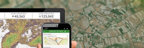
It's without question that human rights are an imperative. Whether that be the right to clean water, food security, or self expression. For #HumanRightsDay2024, we're reflecting on our recent project with @DAI on agricultural resilience in Afghanistan: https://t.co/tX0sgVxG7D
0
0
0
The visual below beautifully transforms a disaster into art, something rarely captured. During 2023, Afghanistan was hit by three impactful earthquakes. Our team used different datasets to better understand their impact. Our earthquake project:
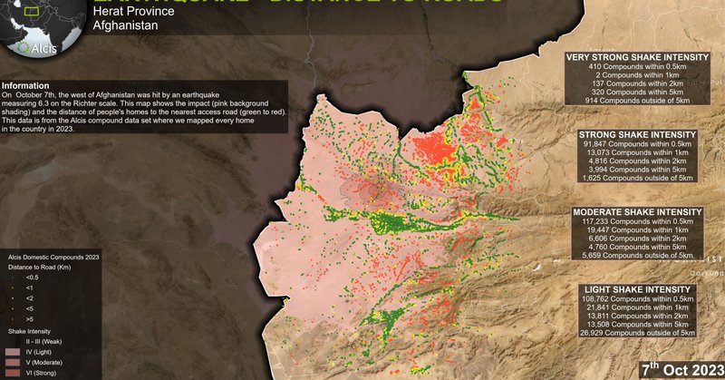
alcis.org
Satellite imagery and maps showing the impact of the Afghanistan earthquakes on October 7th and 11th 2023.
You're looking at earthquakes from inside the Earth. 🌏 Created by Raluca Nicola with the ArcGIS Maps SDK for JavaScript. 🔸Explore the app here: https://t.co/eFuU38cRQn
#ArcGIS #JavaScript
0
1
3