

WeatherTiger - weathertiger.substack.com
@wx_tiger
Followers
4K
Following
600
Media
1K
Statuses
2K
Daily tropical newsletter: https://t.co/kKfG1rZuB3; custom forecasts & modeling for ag commodity markets; met expert witness. Tweets by Ryan Truchelut.
Tallahassee, FL
Joined January 2016
With Cat 4 #HurricaneErin ripping ~20 ACE units so far (and 15-20 ACE to go), the 2025 #HurricaneSeason has rapidly vaulted out of the climatological basement— moving up from <30th percentile to date last week to nearly 80th percentile today. More %ile gains from #Erin to come.


0
9
76
Historically, storms where #TropicalStormErin is now have a 10-15% chance to make U.S. landfall. #Erin is unlikely to beat the odds, despite what you may have seen from drama mongers with names like Gulf Hurricane/Monster Jam ALERT HQ. The real deal:.

1
0
5
Right now, indications are that Erin will be a strong hurricane that passes north of the Lesser Antilles and well east of the continental U.S. If that story changes, I’ll let you know— read my full thoughts and subscribe for daily updates at the link:.

0
0
2
#TropicalStormErin has developed in the eastern Atlantic. Despite chatter, odds are stacked against U.S. impacts- just ~5% of storms near Erin's location struck the U.S. coast. Worth watching as #Erin will likely become the first major #hurricane of 2025, but no cause for alarm.

2
9
66
August will begin with minimal tropical activity through the 10th. That frees me up for another entry in my guided tour of #hurricane season, this time looking at August: when the heat index & prospect of serious tropical threats are gonna make you sweat.

0
1
3
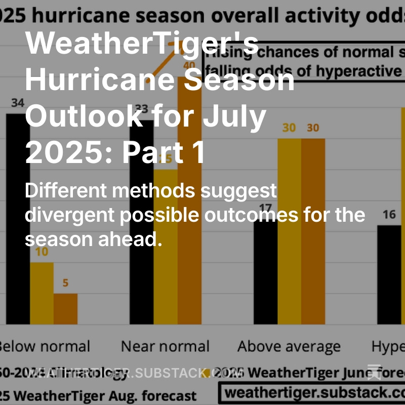
Hurricane Season 2025 is off to a slow start, but nearly 95% of ACE is still ahead. In today's updated seasonal outlook (part 1), WeatherTiger’s real-time algorithm is making sense of conflicting data, with a likeliest outcome of ~135 ACE. More here:
0
1
5
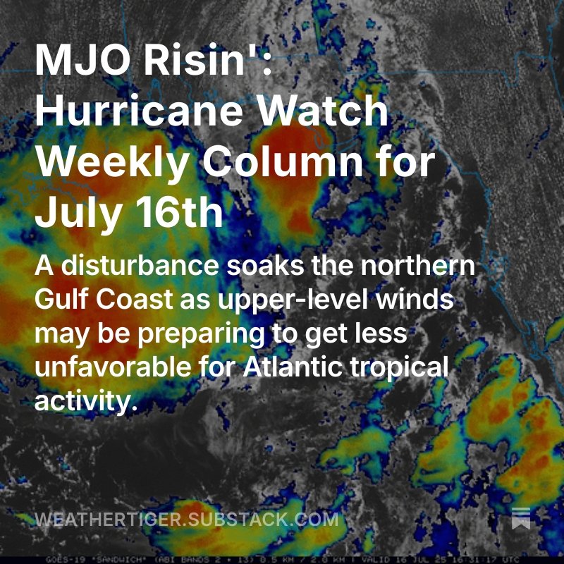
Irritant-level tropical threats roll on, with today’s focus on a disturbance (#Invest93L) in the northern Gulf which may cause flooding in Louisiana/Mississippi. Watching that disturbance and changing upper-level winds in this week's hurricane column:.
0
0
5
NWS Excessive Rainfall Outlooks for the next 5 days show the flood risks shifting west with time. Highest probability of flooding and heaviest accumulations are likely late Thursday into Saturday as #93L slows down and begins turning north into central Gulf Coast.
0
2
3
The low- and mid-level centers of a disturbance (#Invest93L) about to cross Florida are misaligned due to shear, but development is still possible in the Gulf. Serious flood concerns later this week in Louisiana/Mississippi. Daily tropical bulletin here:
1
11
48
Interestingly, late July/early August ACE is one of the most positively correlated periods with elevated hurricane activity over the rest of the season. Likely linked to 30-60 day period of the MJO➡️higher probability of favorable conditions in late Aug/early Sept season peak.


A convective pulse is forecast to move across the Atlantic into Africa during late July and early August, potentially bringing the season's first chance for a hurricane.
2
7
49
Close your eyes and picture what a hurricane looks like on the ground. Whatever you’re visualizing, it probably isn’t inland flash flooding. It probably should be. This week’s tropical column looks at why heartbreaking weeks like this one keep happening:

0
0
2
RT @NHC_Atlantic: NHC will initiate advisories on Tropical Depression Three, located in the Atlantic Ocean offshore of the southeastern Uni….
0
239
0
A disorganized tropical disturbance means #Florida and the coastal SE U.S. are in for a rainy wind-up to the ID4 weekend, but any tropical development of this feature should be limited and is no cause for alarm. Tuesday tropical goings-on and more here: .

0
1
5
Florida and the eastern Gulf Coast will be wet this week due to a stationary front/upper disturbance combo that has a slight chance of tropically organizing in 4-8 days in the northeastern Gulf or near-shore Atlantic. More in today's tropical bulletin:
0
10
34
New tropical depression incoming. Like Andrea, will also be very weak and short-lived. If it reaches tropical storm intensity, #Barry is the next name on the list.

NHC will initiate advisories on Tropical Depression Two, located over the Bay of Campeche, at 500 PM EDT (2100 UTC).
1
2
11
So, so bad. The most impactful loss of a forecast tool so far. Losing SSMIS, we won't know if a hurricane's structure is changing to indicate rapid intensification overnight. It'll also degrade forecast skill for all weather because SSMIS data is a key input to computer models.

A huge blow was dealt to hurricane forecasters this week as a critical tool was abruptly terminated by @DeptofDefense and @NOAA. The immediate discontinuation of data from 3 weather satellites will severely impact hurricane forecasts this season and beyond

1
3
9
RT @Princeton: You may have seen him on @Jeopardy or on TV breaking down major storms. Meet Dr. Ryan Truchelut '08 aka Weather Tiger (@wx_….
0
1
0
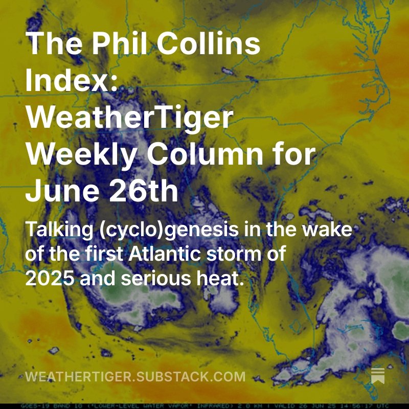
Man it’s a hot one. Fortunately, just like the ocean under the moon, the first month of hurricane season has been so smooth that you could forget about it. Today's column looks at why hurricanes form with an assist from Carlos Santana and Phil Collins.
0
0
3
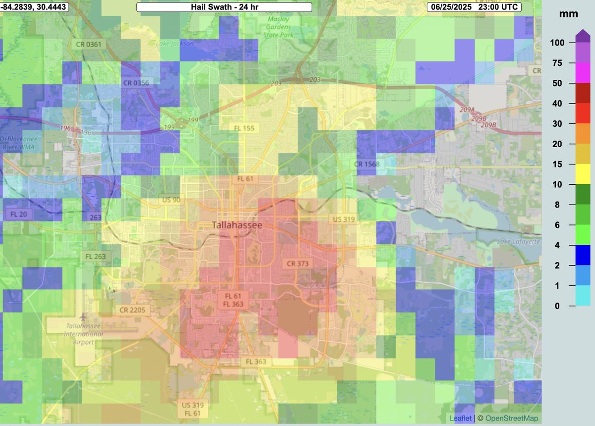
Widespread storm spotter reports of 0.75"+ hail across the #Tallahassee metro area this afternoon. NOAA's MRMS dataset shows an estimated broad swath of severe, 1-1.5" hail (reds/dark reds) as occurring across central, south, and southeastern sections of town.

0
0
1
