
Joe Boomgard-Zagrodnik
@joejoezz
Followers
5,600
Following
877
Media
1,218
Statuses
8,305
PNW weather/climate forecasts, analysis, and commentary. Scientist at @Verisk , PhD @UWAtmosSci , West Seattle islander, dad, beekeeper, @TacoTimeNW fan, he/him
Seattle, WA
Joined March 2009
Don't wanna be here?
Send us removal request.
Explore trending content on Musk Viewer
Usyk
• 402945 Tweets
WALK IN SKECHERS WITH APO
• 158767 Tweets
Joshua
• 133857 Tweets
Sarah
• 112108 Tweets
#Amici23
• 106172 Tweets
#RingOfFire
• 63725 Tweets
#precure
• 59963 Tweets
プリキュア
• 47117 Tweets
しんちゃん
• 21483 Tweets
しんのすけ
• 13875 Tweets
#仮面ライダーガッチャード
• 13578 Tweets
Belgrano
• 12424 Tweets
切り取り
• 12357 Tweets
Preakness
• 12203 Tweets
全スマホ保有者
• 12154 Tweets


Pinned Tweet

It's been a bit, but the Convergence Zone is back with a summary of the cold spring of 2022:

8
16
106
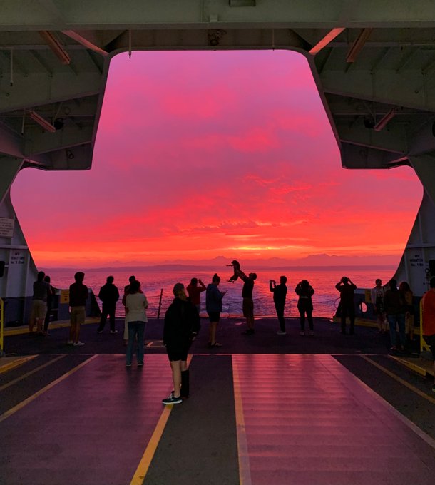
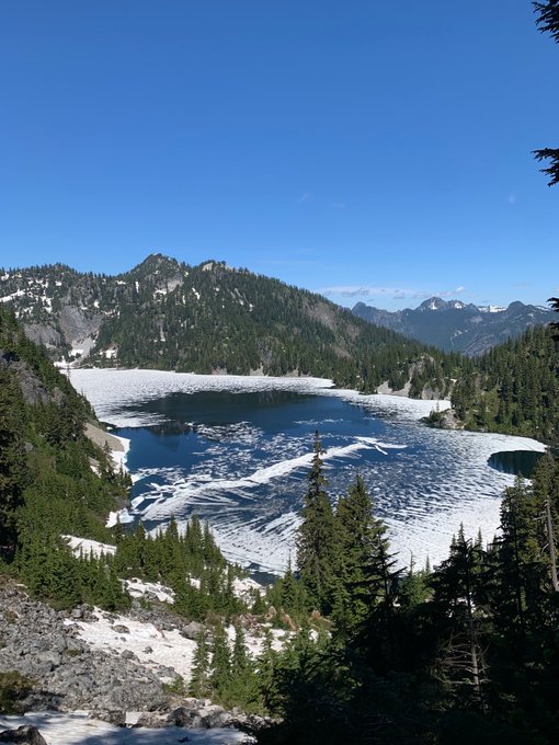
A sight for sore eyes. Roughly 9 days to go until the switch flips to chilly and rainy.
51
85
1K
I appreciate that Seattle can deliver 50-something degrees and rain on any day of the year.
28
72
954
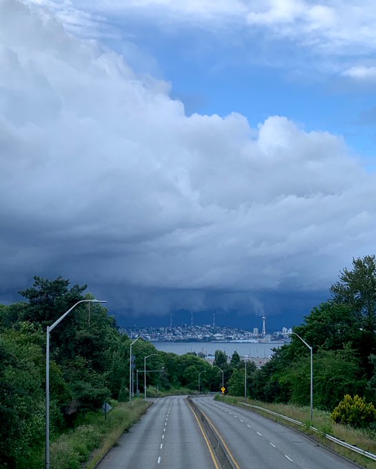
The transition to rainy season is coming, and it’s going to be an abrupt shock to the system.
Seattle is likely done with temperatures above 70 F until March or April.
2-3 inches of rain should fall by Halloween. And November is the rainiest month of the year. Enjoy!
36
51
812
Seattle's sunset time has moved from 4:17 to 4:18 PM. Enjoy the extra daylight, spring is right around the corner!
15
25
631
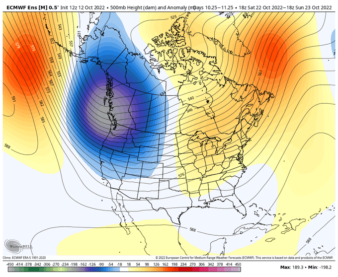
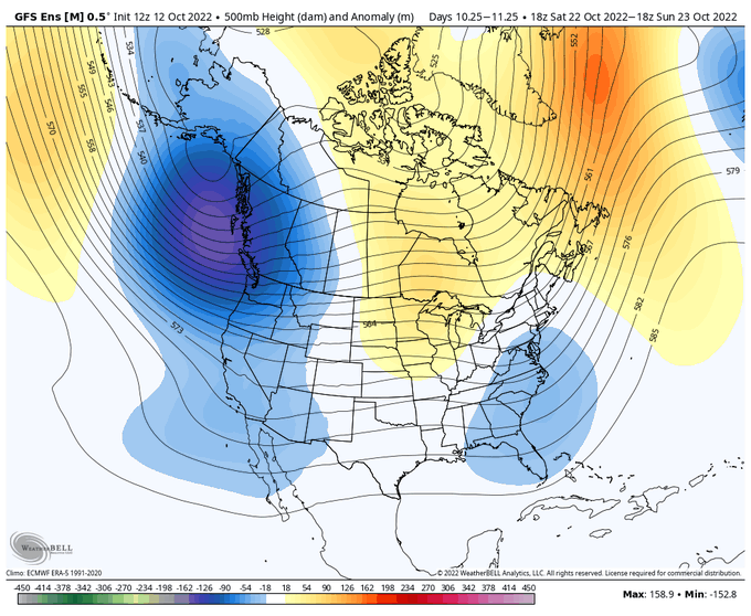
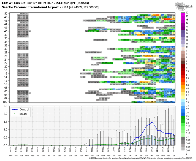
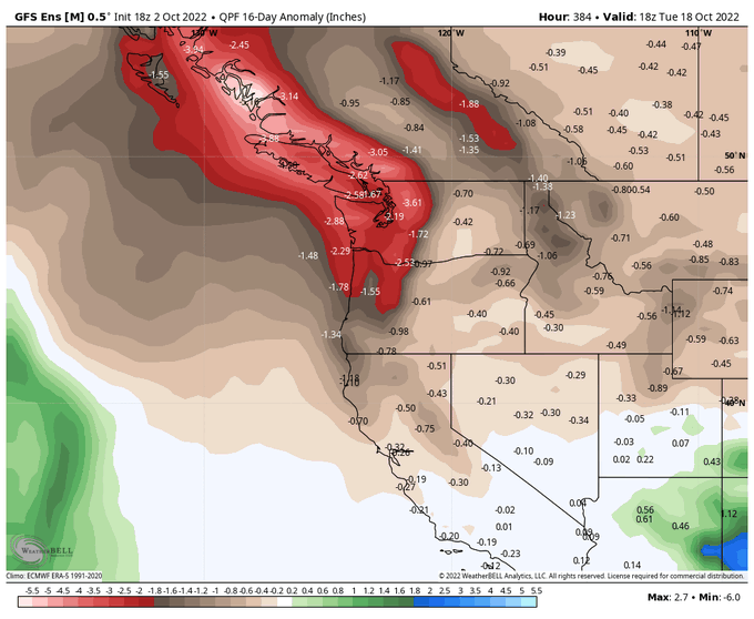
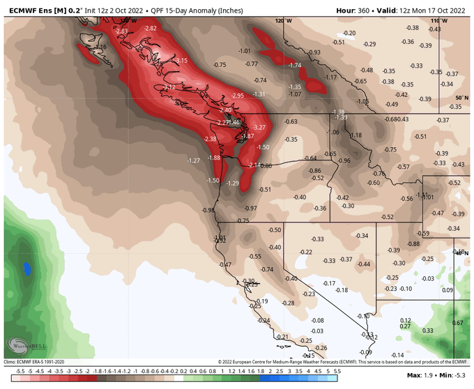
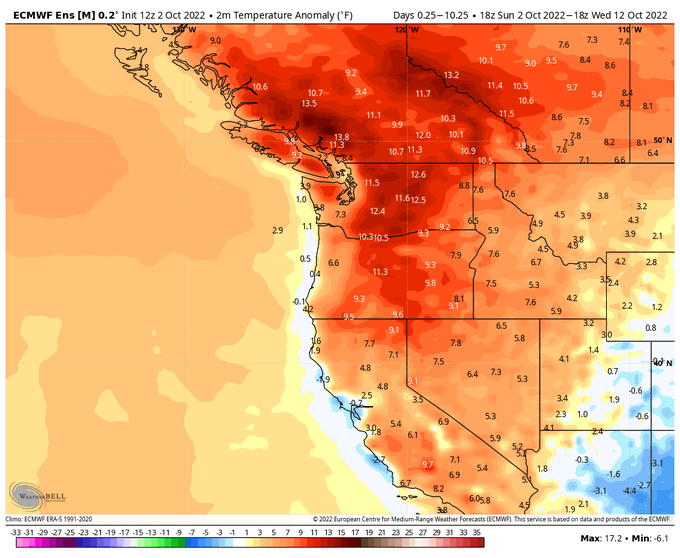
These model runs are stunning. No rain in the entire 16 day GFS run.
October temperature records are going to be smashed beyond recognition if there isn’t a rapid shift to a cool pattern at the end of the month.
25
93
574
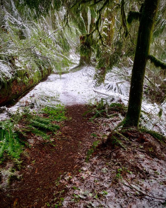
First snow of the season at Paradise on Mt Rainier.
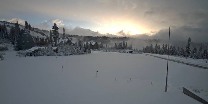
10
66
387
Next week is going to be fun! Beautiful cold pattern and 2-3 storms that could bring some snow close to sea level in western WA/OR.
Too early to know details…
14
13
381
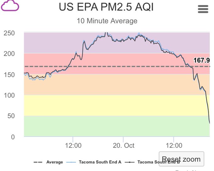
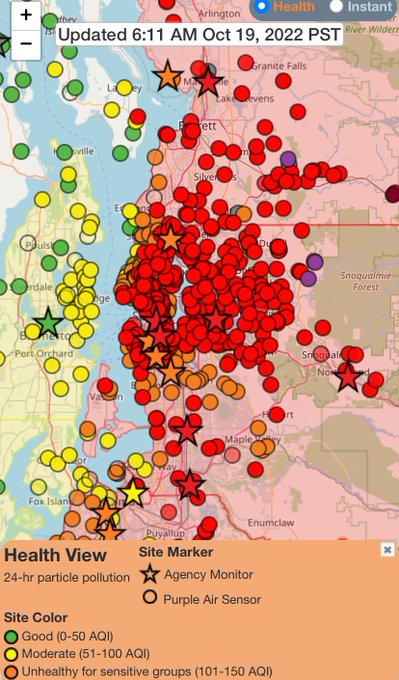
The clean air has reached Tacoma!
Say goodbye to endless summer, this is it!

14
19
358
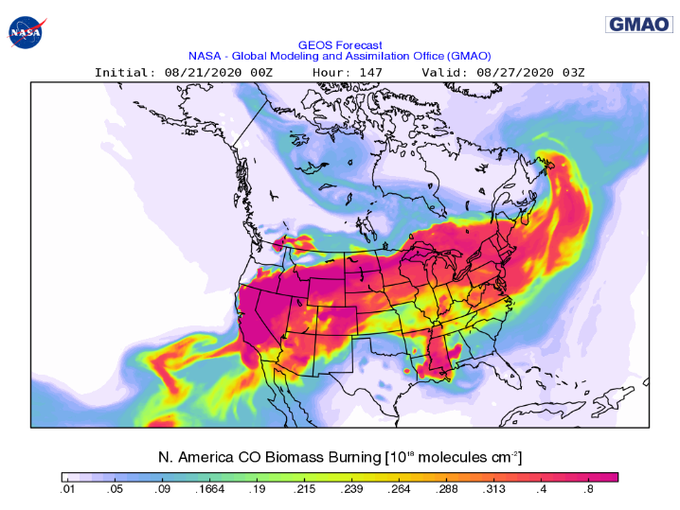
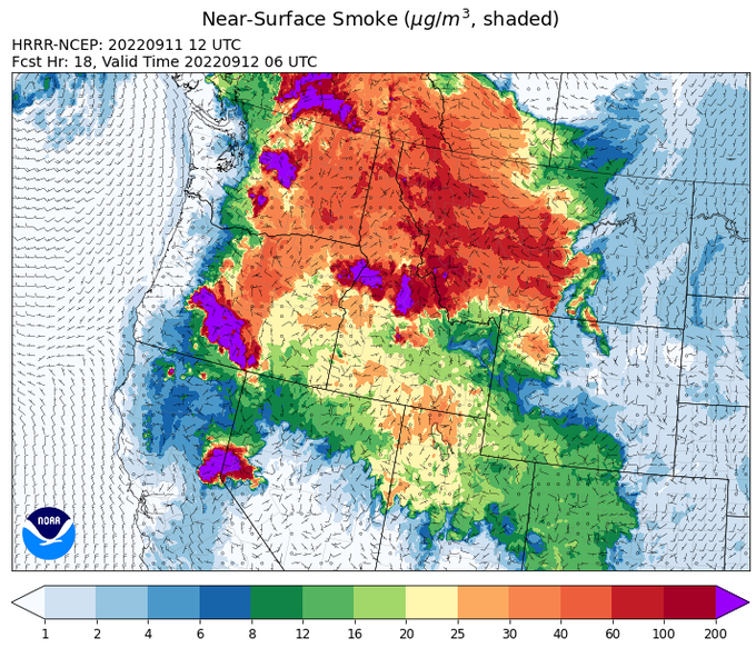
Model forecasts indicate that wildfire smoke will cover the majority of the lower 48 by next week.
16
257
325
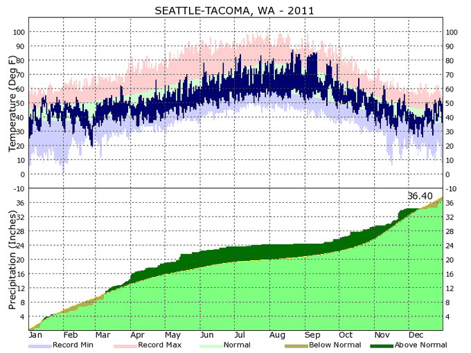
Seattle's 2022 weather has continued to closely resemble 2011. Similar to the present, the PDO was deep in negative territory in 2011.
"Summer" 2011 in Seattle started around August 20 or so. There were only 5 days above 80 F prior to mid-August.
53
34
321
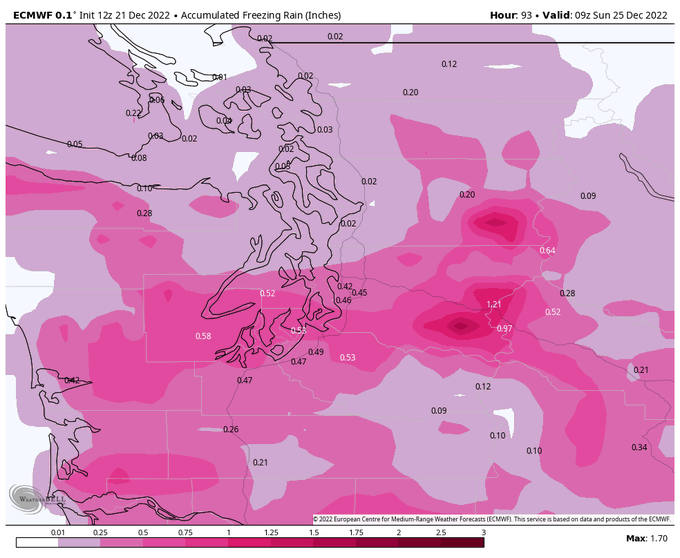
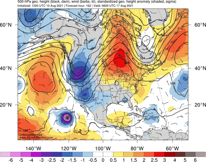
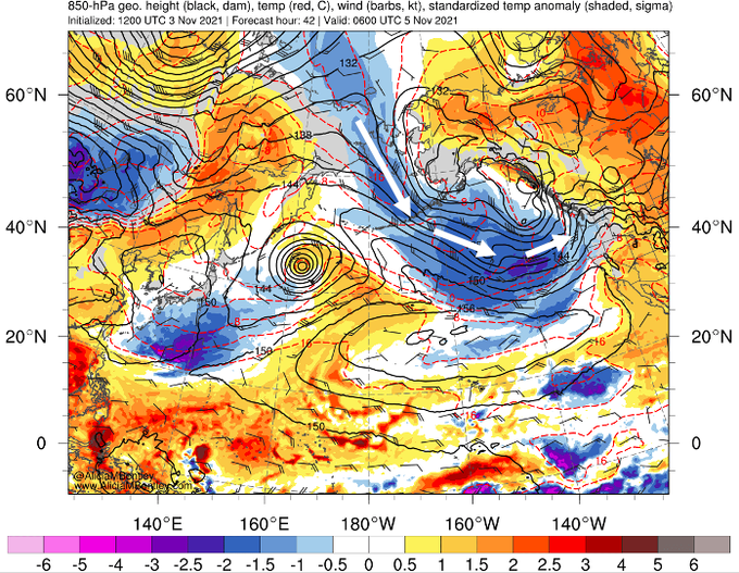
I'm reluctant to hype a storm that is ~8 days out, but both the GFS and Euro are now showing a once-in-a-decade warm front/overrunning snow/freezing rain storm on one of the busiest travel days of the year. So it might be worth keeping an eye on the forecasts.
17
21
307
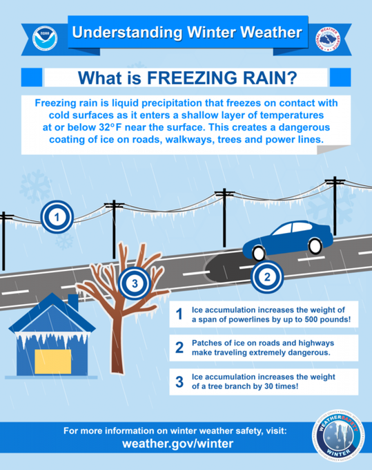
Hard to say exactly what 1/3"- 1/2" of freezing rain might do to our trees and power lines on Friday but my preparation will be similar to if a strong windstorm was expected to hit. Potential for impassible roads and power outages lasting for days.
22
70
300
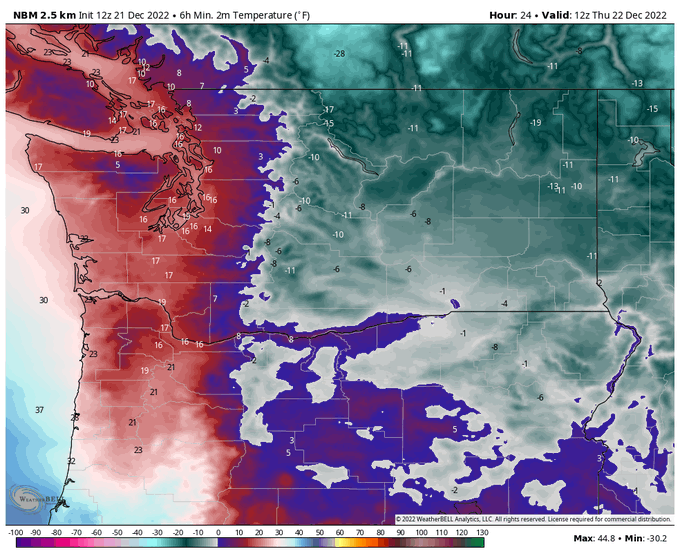
Tonight will be one of the coldest nights across Washington in recent memory. Here are some of the record lows that might be threatened tonight:
Seattle: 14°F
Bellingham: 10°F
Spokane (KGEG): -15°F
8
61
269
Historically, the upcoming Seattle heatwave is one of those 'once in a decade' type events for August, unless you are referring to the most recent decade which had notable August heat waves in 2010, 2012, 2014, 2015, 2016, 2017, 2018, and 2020.
7
96
264
Odds of arctic air reaching the PNW continue to increase. At this point, it's fair to say that sub-freezing temperatures and snowflakes are more likely than not in the Seattle metro area beginning next Wednesday and continuing through the following weekend. [1/2]
7
19
257
The last day of smoke is the worst day of smoke in Seattle.
This is it! Tomorrow will have onshore flow and it will be raining by Friday afternoon.
9
37
239
Finally seeing a strong signal for a shift to rainy season in about 10 days. Bring it on!
12
9
222
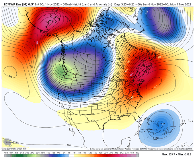
Finally a pattern that will put a dent in the abysmal mountain snowpack across the western US and Canada. Beginning next weekend.

Right on schedule, here comes the western trough/-PNA early to mid month.
17
21
177
7
22
214
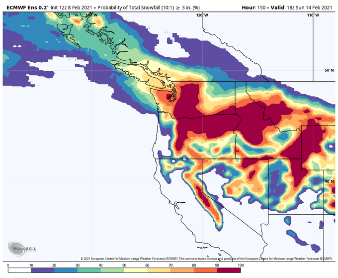
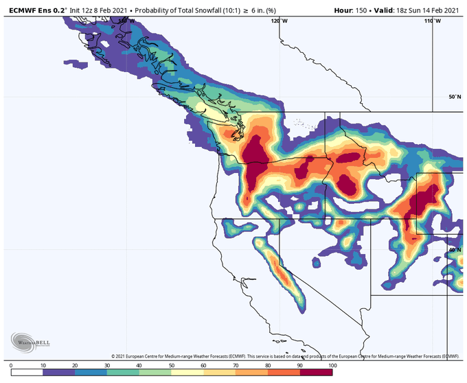
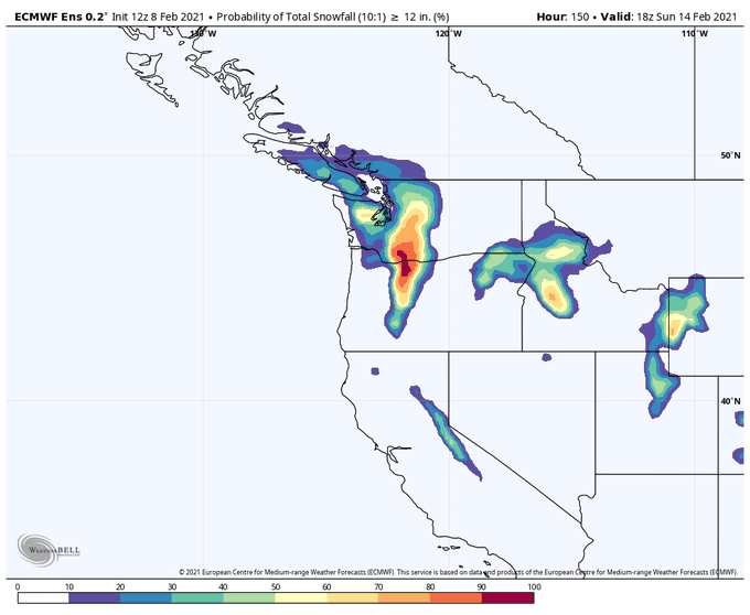
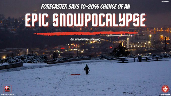
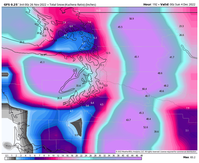
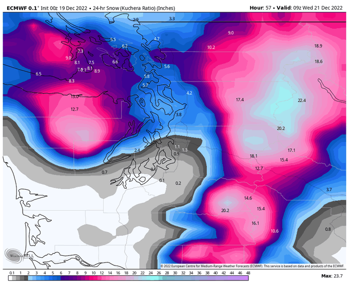
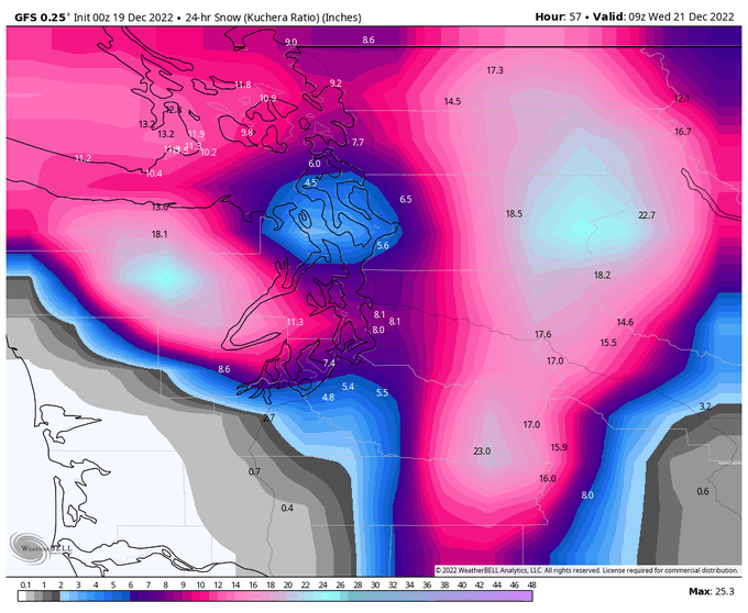
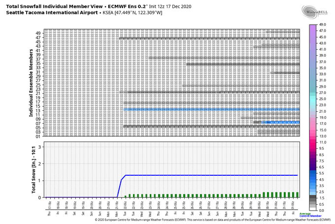
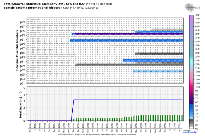
Latest 12 UTC Euro ensemble odds of >3", >6", and >12" of snow by Sunday evening. For Seattle, looks like an 80% chance of 3"+ of snow, a 60% chance of 6"+ of snow, and a 10-20% chance of a 12"+ epic snowpocalypse. Odds are an improvement over the 00 UTC run.
5
34
205
A marine push is bringing much cleaner air to western WA this morning. Air quality is expected to continue to improve with most of the surface smoke gone in Seattle by late evening (11 PM pictured).
Smoke will persist near the fires and east of the Cascades.
3
22
197
What have I done??? :-) :-)

Seattle-based atmospheric scientist
@joejoezz
says Western Washington has a 10-20% chance of a 12"+ epic snowpocalypse this week 👀
❄
15
9
51
22
5
182
The
@MountRainierNPS
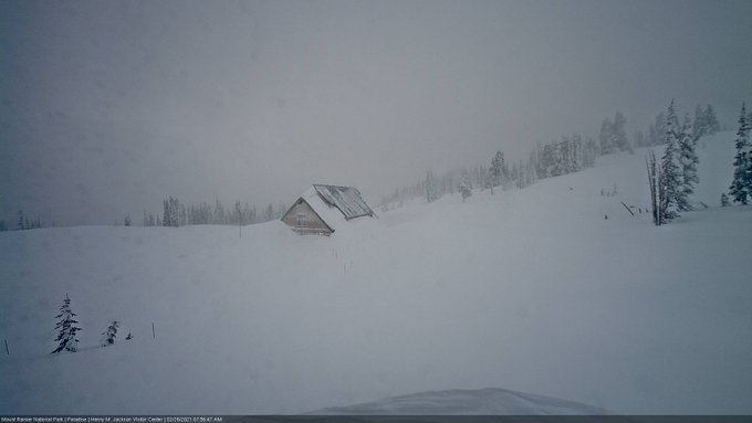
Paradise visitor center is going to disappear if this winter keeps going. Snow depth is now 224 inches (18+ feet).
12
38
182
I've been thinking about doing this for a while, but for some reason this evening seemed like a good time to start a PNW-themed weather blog. So here's my first post about the rain today:
11
28
177
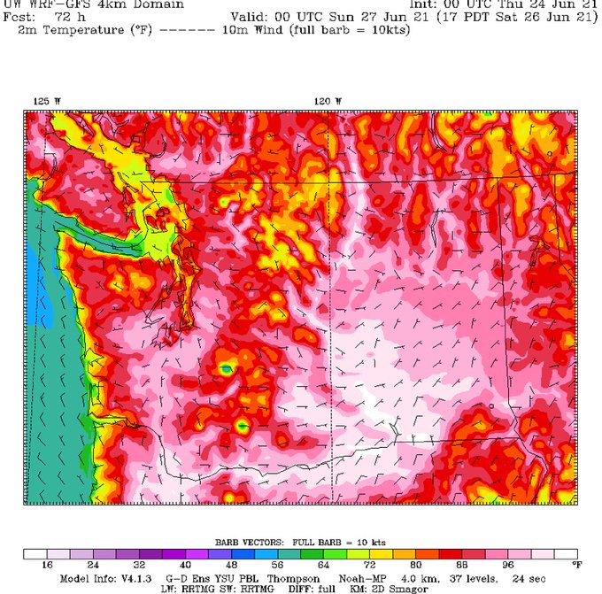
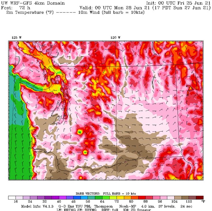
If Seattle can hit 100-105 in June 2021, what will a future heat wave look like in 2040? 2060? 2080? What happens when we warm the planet by another 1-2 degrees C?
23
41
172
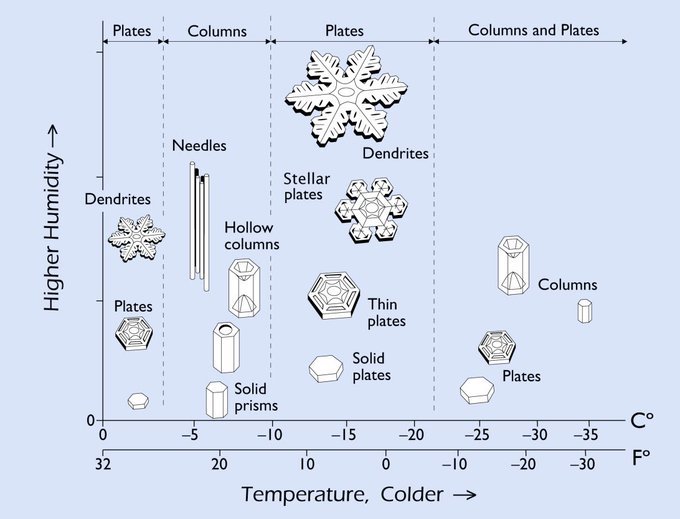
Did you know snowflake type depends on the temperature and humidity in the environment in which they are formed? Tonight we’re seeing tiny flakes (plates/needles) that were formed in a cold environment and it is too cold at the surface for them to stick together (aggregate).
6
42
169
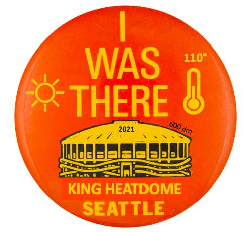
How unprecedented is this heat wave? So unprecedented that the UW added more colors to the top end of their temperature scale. It goes up to 120 now!
8
63
170
It's time to prepare -- the coldest temperatures of the winter are headed for the PNW at the end of next week. Some thoughts on the forecast uncertainty here:

7
22
170
Since Twitter has no content moderation anymore, feast your eyes on this!
23
3
169
This atmospheric river is approaching Seattle from an unusual direction (west-northwest) which has resulted in a huge rain shadow directly over the city.
6
13
164
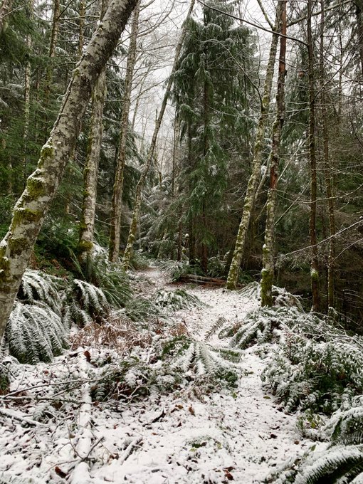
Found the snow this morning just below 2,000 ft elevation near North Bend.
1
10
158
Time to check “massive smoke plume in May” off your PNW climate change bingo card.
7
27
157

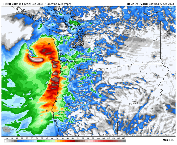
Tomorrow’s windstorm is a potent one that is not to be messed with. I suspect there are going to be a ton of power outages + tree damage in the south/central Sound due to saturated soil + more westerly wind than usual. Normally a ~973 hPa landfall would get more headlines!
6
23
150
7 PM dew point is 65 F (!!!) at Sea-Tac airport which is one of the highest values ever recorded at that site.
14
10
147
Tuesday evening’s system is going to pack a punch. Heavy rain, lightning, wind, and possible waterspouts/tornadoes along the coast. A
@SeattleWXGuy
special.
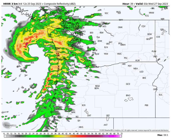
6
20
149
Rapid growth of wildfires (black hot spots) as seen on shortwave IR. In the last frame or two it looks like a new fire has appeared west of the Cascades in Oregon, which is very concerning.
8
63
138
Endless summer goes on…
…the models even have given up teasing a pattern change. No sign of rain.

8
28
143
How much is it going to snow this week? You asked, I answer.

11
32
144
A new wildfire along US-2 near Skykomish appears to be blowing up. Not good.
15
46
140
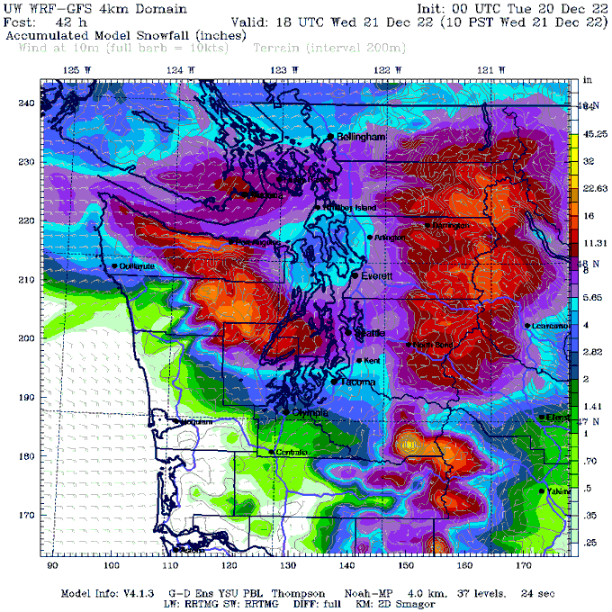
Latest UW-WRF, which appears believable based on how this storm is evolving so far.
Almost all of this snow would fall between 4-10 AM in the Seattle area. Or it will be rain…we’ll find out when we wake up I guess.
16
10
140
Woke up to 40 degrees 🌴
A bit of snow is possible later, but I think this is going to come pretty close to a zero, at least in Seattle.
Never doubt the European model 👑
22
2
138
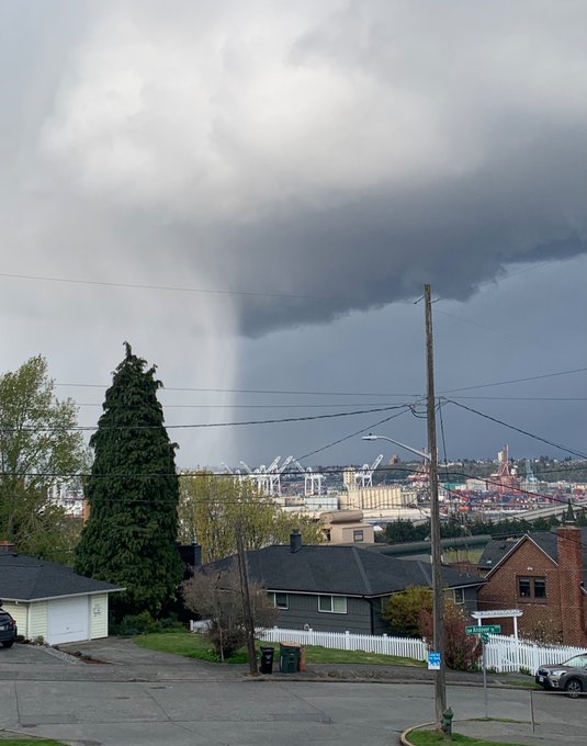
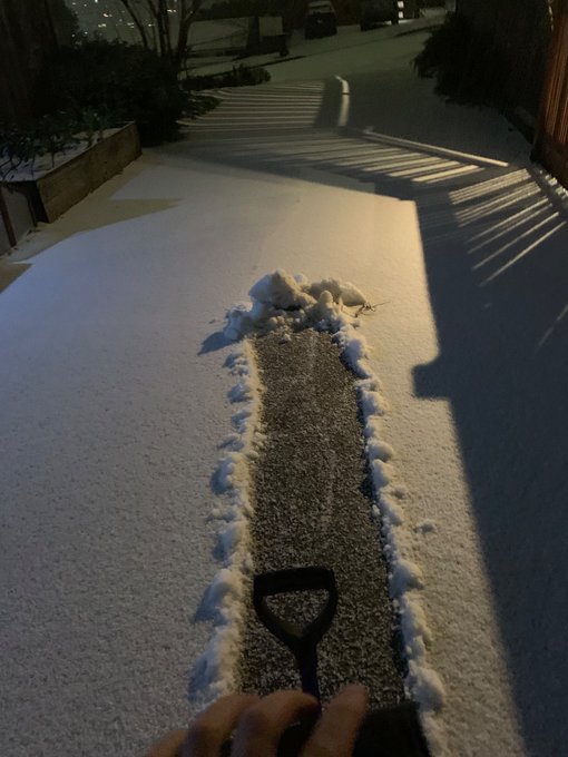
Around one inch of hail fell in 10 minutes from this thunderstorm in West Seattle. Enough to shovel!
@NWSSeattle
@westseattleblog
6
18
138
I know nobody is looking forward to the heat wave, so here's the GFS forecast for one week from today. Look at that beautiful blue and purple trough. Just think of how cloudy and blustery it's going to be. Plus there will be rain showers as well. Aaahhhhhh.
21
11
133
The first big storm of the fall is only 3 days away -- here's what to expect.

4
28
127
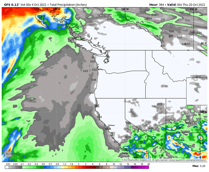
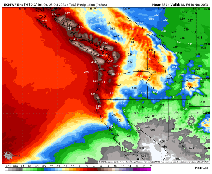
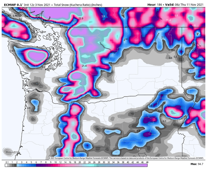
November is the wettest month of the year in the PNW and this year the rain will arrive right on schedule on Wednesday. Here’s the model-predicted rainfall through the first 10 days of November. Minimal mountain snow is expected at pass level, this will be a warm storm cycle.
3
19
133
Can we attribute this heat wave to climate change?
Using historical records, we can estimate how often a summer day in Seattle will exceed 105 F:
20th Century: once every 379 years.
21st Century: once every 78 years.
***nearly 5 times as frequent due to 2 F of warming***
13
39
131
While Portland deals with a snow/ice storm today, I’m increasingly concerned that the Seattle area will also see freezing rain with a warm front on Tuesday.
16
10
126
Some personal news — today is my last day as a postdoc at WSU. My next role is with the weather solutions group at
@Verisk
. I’m excited to begin a new chapter with new challenges.
And no, I’m not moving anywhere, thanks to remote work I’m not even changing offices :)
15
1
128
Flipping between spring and winter on Tiger Mountain today
0
3
126
This is just crazy, the wildfire smoke is now being pulled into the upper low centered around 145 deg longitude. Halfway to Hawaii from the lower 48.

2
48
120
Seattle, are you ready for boring weather? The forecast for the next 1-2 weeks is for occasional light rain and near-normal temperatures.
Take a breather while the eastern US gets to have a little fun for once.
9
4
119
11
20
116
On satellite it looks like the stratocumulus clouds are being sucked out of Puget Sound! The clouds reveal an increase in southerly flow ahead of an approaching frontal system.
6
20
114
Today will likely be the hottest June day on record in Seattle, a record that will be broken tomorrow and again on Monday.
Drink plenty of water, stay in the A/C or shade, and look after your neighbors.
4
19
111
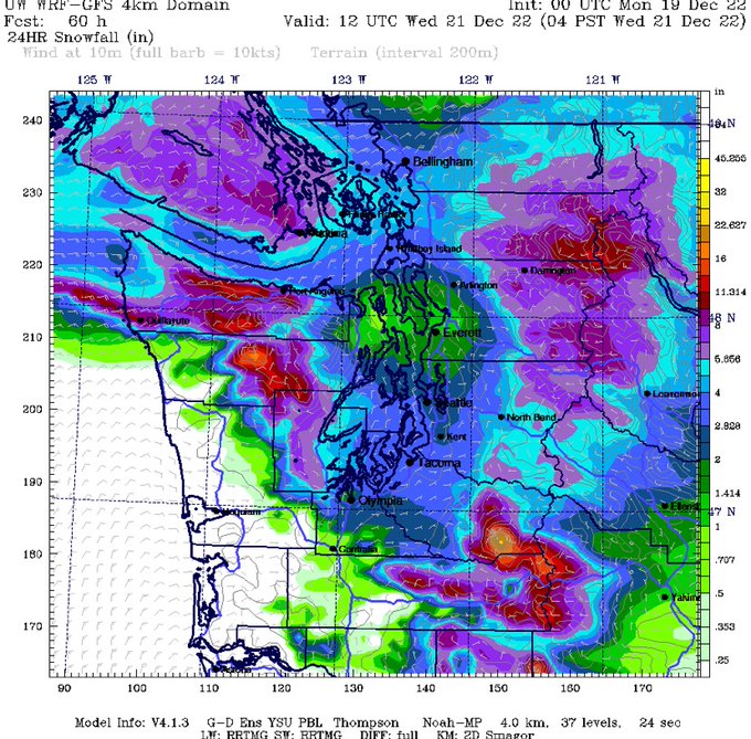
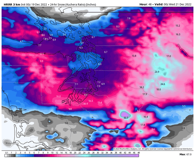
Tuesday continues to be a tricky forecast. Sharp rain/snow line, a possible snow shadow, impressive snowfall rates. I have no idea what blend of these snow maps will be right so feel free to draw your own conclusions.
12
12
114
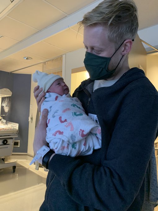
Yet another busted forecast by me..."baby in two weeks" should have been "baby in two days". On Jan 30 we welcomed Mia Boomgard-Zagrodnik into the world. She's wonderful and I couldn't be happier. Mom and baby are doing great.
I officially changed my last name to Boomgard-Zagrodnik today. Since that's quite a mouthful I also go by Joe 'BZ' or 'BoomZag'.
@BBoomgard
and I are expecting a baby girl in two weeks so it's going to be a busy time in our household :)
20
0
95
16
0
112
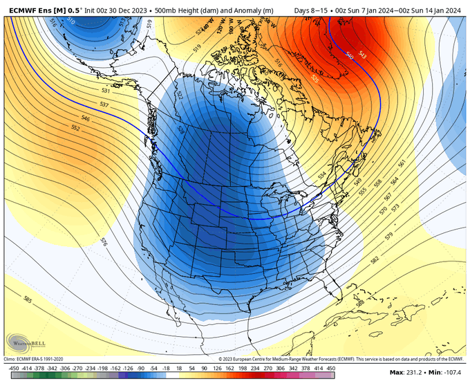
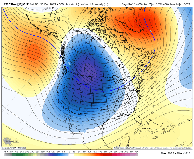
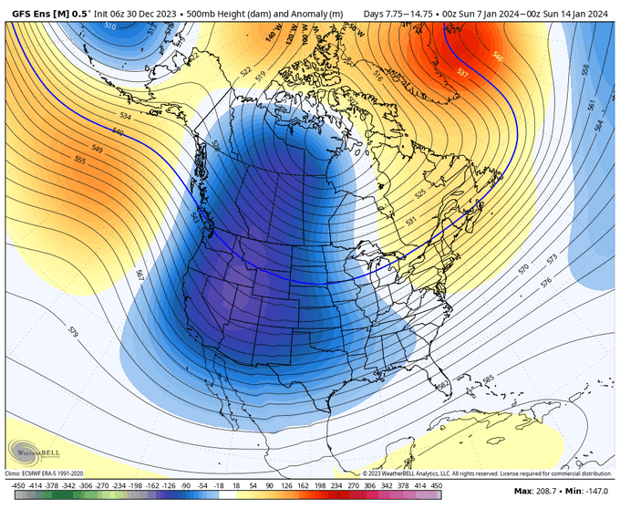
All aboard the Siberian Express! Anomalously cold air from Siberia will cross the N Pacific and lower freezing levels from the weekend->early next week. A parade of fronts embedded in the cold air will deliver plentiful mountain snow. An excellent start to the snow season :)
5
9
107
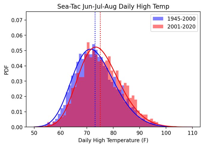
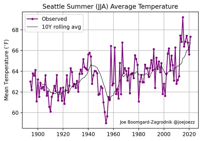
With a week to go in meteorological summer, Seattle is likely to finish with its 4th warmest summer on record. The top 3 are 2015, 2013, and 2018.
The 7 warmest summers in the past 128 years have all occurred in the last decade.
@NWSSeattle
@ScottSeattleWx
@KSeattleWeather
7
32
96
Will Seattle wake up to a wintery scene tomorrow morning? Keep an eye on this low and its associated banded precipitation. Ideally the low should end up near Montesano by 6 AM w/ a narrow but well-defined snow band in the central Sound. Will the stars align or will it be a bust?
7
8
100
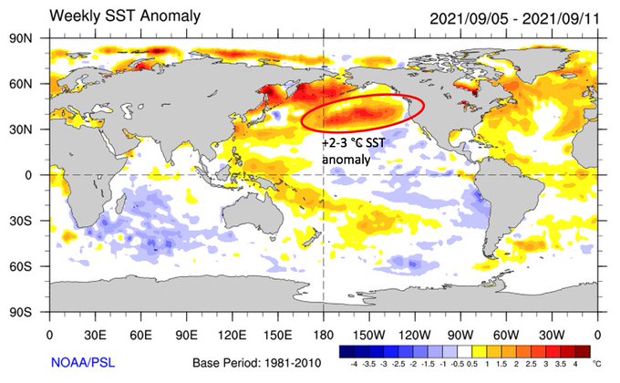
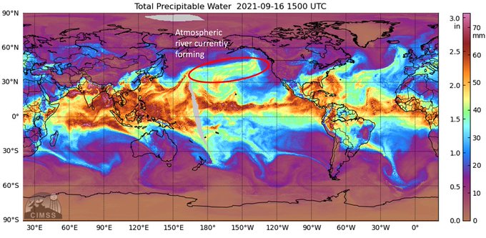
The atmospheric river headed for the PNW is being supercharged by a huge warm sea surface temp anomaly in the central Pacific. Higher SST -> more moisture -> more rain. Great for September, but more of these storms will cause flooding. Climate change is certainly a culprit here.
7
33
102
Always fun to wake up to a cold house with the furnace not working on the coldest morning of the year!!!
(after the initial panic and 5:30 am YouTube watching I have successfully gotten the thing to run…for now…)
6
1
105
New blog post: 5 reasons why a significant Puget Sound windstorm occurred with almost no warning

12
20
100
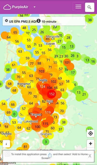
It’s amazing how fast surface air quality can degrade when the atmosphere doesn’t mix out pollution.
11
7
101
Another model cycle goes by and we still have no idea what weather Seattle might see this weekend except cold.
Cold and sunny?
Cold with clouds and flurries?
Cold with a major snowstorm?
Cold with snow -> freezing rain -> rain?
Cold with a quick transition back to rain?
9
2
101
Easy to see where melting aloft is occurring on radar. Everything that reaches the ground south of the blue line is likely to be sleet or freezing rain.
17
9
98
The wind turned southwesterly at Sea-Tac airport and the temperature has now dropped from 98 to 82 F in less than an hour. Hooray!
2
14
101
I'll own it, this was my worst forecast of all time. I thought there was no way it was going to snow today. Too warm, no arctic air. Even this morning I was pretty sure it wouldn't snow at sea level. Excited to be wrong though :)
#reversejinx
Is it going to snow in Seattle next week? No, it's not.
Will deterministic weather models occasionally provide whacky 120 hour forecasts? Yes, they will.
12
4
42
13
0
97
Current weather is “violent drizzle”
*The strong winds are likely helping cloud drops grow large enough to fall out as rain by accelerating collision-coalescence.
8
10
95
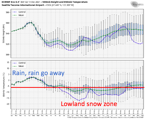
Using our rough 850 hPa temperature < -6 °C threshold, Seattle will be in the "lowland snow zone" from roughly Christmas day through New Year's Eve (green line = most likely forecast).
Will there be moisture? Probably, but timing and possible snow amounts remain unknown.
5
15
91
This time we have only ourselves burning fossil fuels to blame for the terrible air quality under the inversion.
8
9
96
@KSeattleWeather
Imagine if we had paired this with a low snowpack winter and a dry/warm spring. It could be even worse, which is scary.
3
1
94
I officially changed my last name to Boomgard-Zagrodnik today. Since that's quite a mouthful I also go by Joe 'BZ' or 'BoomZag'.
@BBoomgard
and I are expecting a baby girl in two weeks so it's going to be a busy time in our household :)
20
0
95
Right in front of me now…losing visual with the heavy rain.
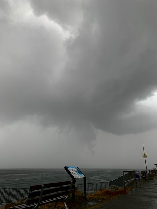
4
6
94
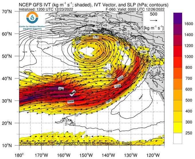
A remarkable “bomb cyclone” will develop off the PNW coast on Thursday. More on the meteorology behind this storm on the CZ:
5
31
93
I would recommend getting home before 7-8 PM tonight. Even 0.1" of ice could cause chaos on any unsalted roads.

⚠️🌨️ Mixed precipitation with pockets of freezing rain will move northward into the region this afternoon and evening, creating potentially hazardous travel conditions during the evening commute. Stay
#WeatherAware
at and .
#WAwx
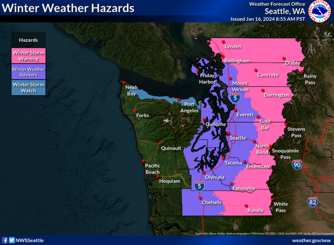
16
104
313
6
14
95
If this ice storm has you sick of the Polar Express, I have good news. A double helping of the Pineapple Express is headed to the PNW.
By Saturday evening it should be close to 50°F in Seattle. With plenty of rain of course. Up to 4 inches in the lowlands by Tuesday night.
6
13
92
This morning was a concerning preview of the western WA communities that will need mitigation/relocation within a few decades as climate change continues to raise the sea level. Eventually we won't need a king tide + low pressure combo to get the water to where it was today.
1
19
92
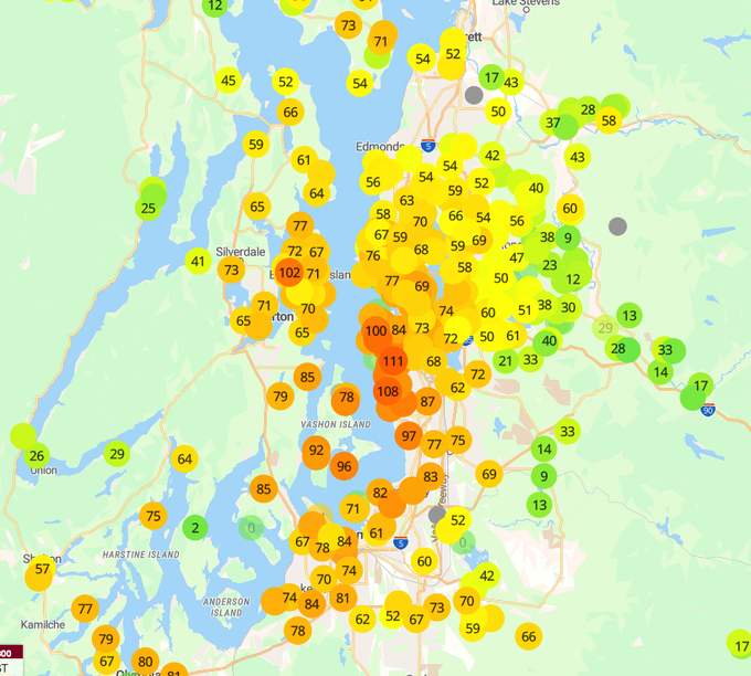
We’re witnessing one of the greatest snowstorms to ever hit Snoqualmie Pass and of course we have no working webcams or weather observations. The storm total was 19” at 10 AM and a temp sensor at Asahel Curtis is still at 32 degrees. Any other reports out there
@SnoqualmiePass
??
6
3
91
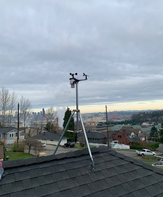
Installed a weather station on my roof this afternoon—just in time for another big storm this upcoming week :)
7
0
89
Here comes the wind. 53 mph gust at Hoquiam last hour.
2
18
90
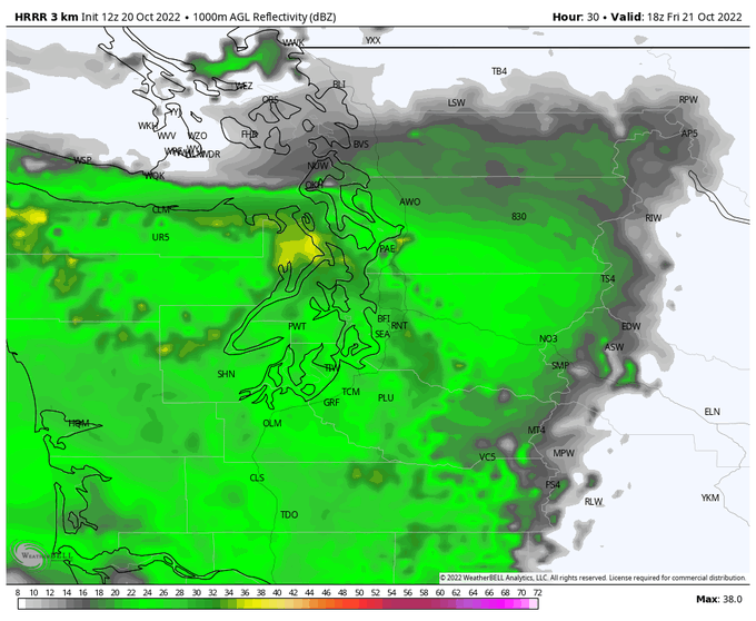
Rain is expected to become widespread over western Washington on Friday morning. Here is the projected radar reflectivity for 11 AM Friday:
3
5
87
Today I am excited to announce that my personal blog will be transitioning to a new weather blog -- The Convergence Zone. To begin on the first day of Water Year 2021, my colleague Ana Ordoñez wrote a nice summary of water year 2020 + a preview of 2021:

5
9
87
New blog post on the rapidly evolving smoke/wildfire situation. It looks like surface smoke will move into the Seattle area in the next 2-3 hours.
8
49
77
The polar vortex is currently being displaced by an ongoing “SSW” event. Could this eventually lead to arctic air reaching the PNW in a few weeks?
5
17
81
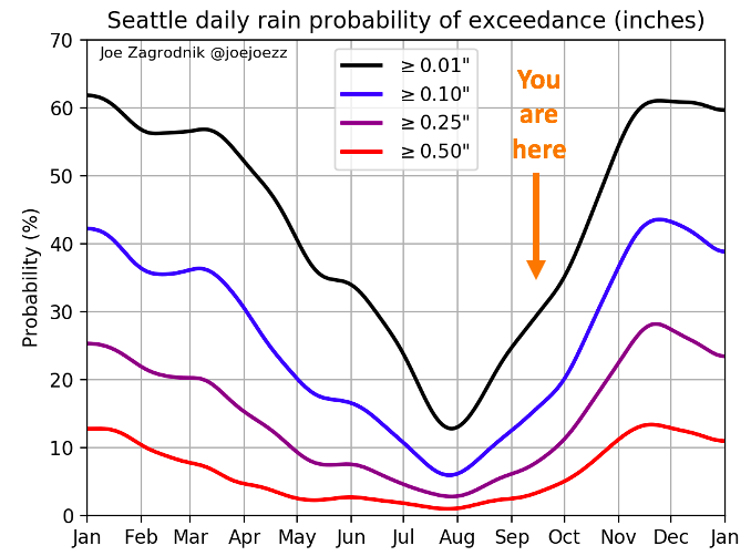
Welcome to Seattle's rapid transition to rainy season!
*It takes just 3.5 months to get from the late July/Aug rainfall minimum to the mid-November peak.
*We have reached the point where measurable rainfall is expected on 30% of days (~2 days per week).
4
20
85
My 8-month-old tested positive for COVID...she caught it at daycare last week. Fortunately she's asymptomatic, but this is a logistical nightmare. At least the weather will be stormy while we're stuck inside for the next 10+ days...
22
0
87
2021 is now the wettest autumn on record in Seattle. 18.83” of rain and counting.
November also surpassed the 10 inch mark earlier this evening.
Seattle picked up another half inch of rain last night. We need 1.50" to reach the fall rainfall record, which will be eclipsed this weekend.
1 - 2006 - 18.61"
2 - 2016 - 17.58"
3 - 1950 - 17.49"
4 - 2021 - 17.11"
5 - 1955 - 17.08"
@NWSSeattle
@ScottSeattleWx
@KSeattleWeather
2
15
60
3
22
85