

Jennifer Bell
@jbellmaps
Followers
1K
Following
1K
Media
23
Statuses
43
ArcGIS StoryMaps & StoryMaps product manager @Esri | Looking for a product marketing manager (b2c) to join our storytelling team | Tweets are my own | she/her
Joined June 2017
Today, @esri launched StoryMaps, a new storytelling tool. Capture your favorite hikes and restaurants, share family updates with friends, and make an interactive map of your travels. I am so proud of our amazing team and I hope you all give it a try on https://t.co/fpi3QaUeSx!

1
26
128

ArcGIS #StoryMaps turns 4 y/o next week—just in time for #EsriUC2023. 🥳🎂 We're celebrating with a new digital magazine featuring you, our global storytelling community. Explore #StoryScape. Read innovative stories, meet storytellers & learn together. https://t.co/WdIMlJzUL6
2
10
41

Read the new Rewilding Story Map from @TompkinsRewild to learn how the rescue of one starving Jaguar is helping restore the species & ecosystems in the #Ibera wetlands, & other #Rewilding success stories. @ArcGISStoryMaps Link to story map:

storymaps.arcgis.com
How rewilding makes a thriving planet
142
339
1K
Hello, storytellers! Jennifer Bell here LIVE on behalf of the ArcGIS #StoryMaps Twitter. Join the #StoryMapsChat NOW for the big announcement. I'm sharing the finalists of the @Esri + @UNSDSN StoryMaps Competition for the #SDGs.
6
15
65
Map Viewer Beta just reached full #SmartMapping parity! Here are 5 more reasons to try it out https://t.co/Vm1JQo9nSz
#ArcGISOnline #esri #dataviz

1
20
67
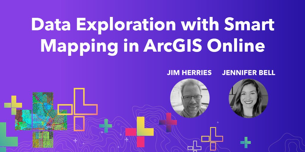
Watch the newly released 2020 DevSummit recording on #SmartMapping. @jherries and I cover COVID-19 maps, the new #MapViewerBeta, dot density, Arcade expressions, and more! https://t.co/0F9p6Ov4TE
3
7
23
Put a label on it! New fonts, multiline labeling, and more in the latest release of #MapViewerBeta. #ArcGISOnline #esri #cartography
https://t.co/sM51uhZQdH
1
9
32
Cluster hundreds of thousands of points at lightning speeds in the new #MapViewerBeta⚡️#dataviz #ArcGISOnline @jherries
https://t.co/pLllqlGvvS
1
10
29
Esri just released Map Viewer Beta! Go behind the scenes of the new color ramps designed with color theory in mind🎨 https://t.co/jcaqxhTzHy
#SmartMapping #MapViewerBeta #ArcGISOnline

0
19
64
Bringing back the '60s with Wurman Dots. #ArcGISOnline and #EsriJS make this fun style possible. https://t.co/xdlFpxX8pj
@kekenes @Geospatial_JB @jherries and Fang Li
1
24
90
Transform data on-the-fly with #ArcadeExpressions. This story provides a recap of a popular demo at this year's #esri UC: https://t.co/VdMg8lJedv

0
6
20
Uncover hidden patterns in your data with Clustering in 3 easy steps https://t.co/j7Ta0EdcrB
#smartmapping #makebettermaps #ArcGISOnline
2
22
49
Thanks for a great #GISDay, California Conservation Corps! I loved your maps of #crime, #homelessness, #breweries, and #PokemonGO. I appreciate what all of you are doing to keep California safe and beautiful.


0
0
23
How well do you know your community? This video explores Esri's new #policymaps website where you can learn fun facts about your city such as the most common language spoken near you. https://t.co/MY1agz1mpc

1
11
31
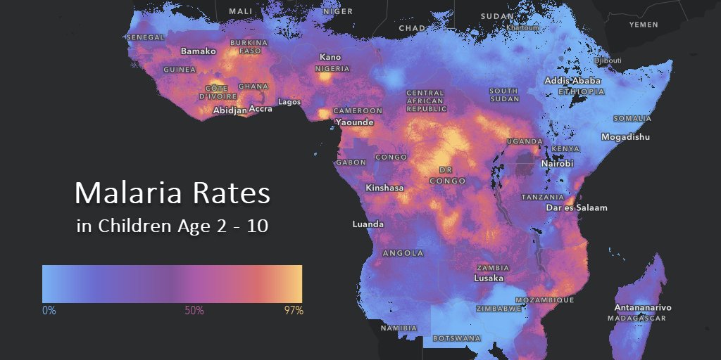
Malaria has significantly decreased in Africa https://t.co/Xvp393aipo Learn how to make the app here: https://t.co/OkTni2NiCw
#Esri #StoryMaps #malaria #MalariaMustDie
0
13
39
Express yourself (and your data!) with Arcade expressions in 5 easy steps https://t.co/RC0RfU5VH7
#esri #smartmapping #arcadeexpressions
0
10
15
Making our streets safer with #Mobileye pedestrian collision warnings and #Esri mapping and analytics. https://t.co/avaIViq5AM
1
11
27
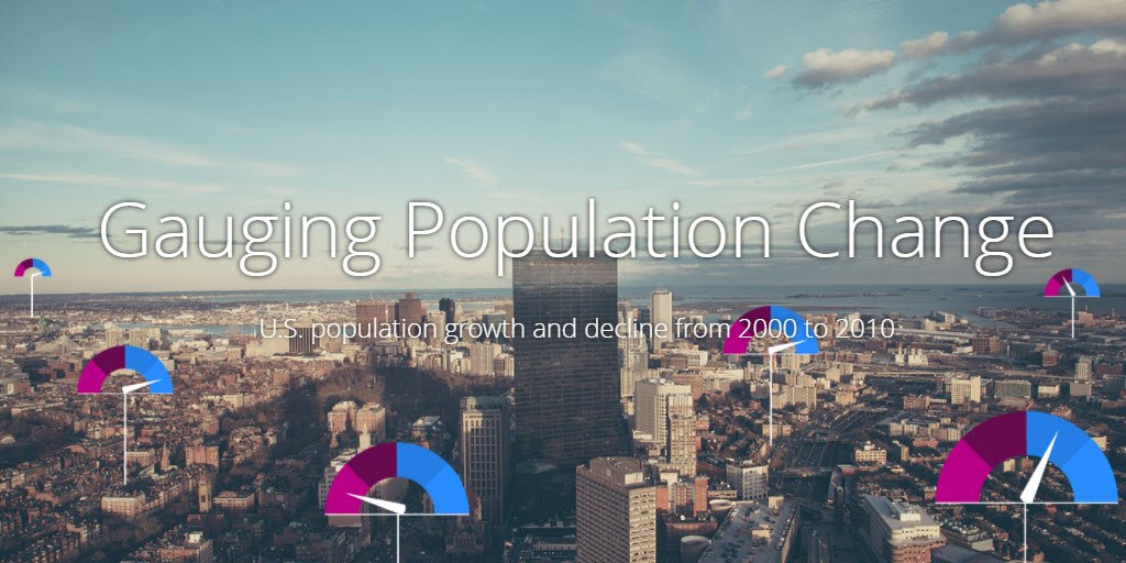
Gauging population change...with gauges! A new way of mapping @uscensusbureau data. #Esri
https://t.co/HZE7eMRtj2
1
3
11

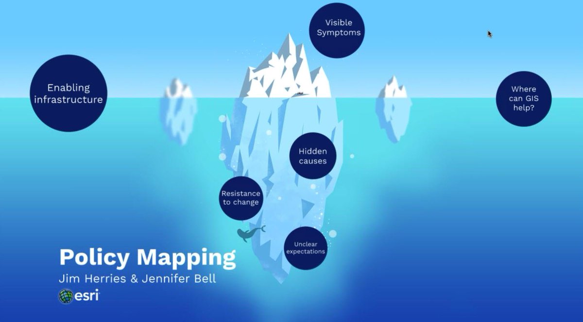
Learn how to make Policy Maps for your #Community using @LivingAtlas. Free webinar presented by @jherries @jbellmaps
https://t.co/NpAkJ3OKaq
0
10
11

On #GISDay celebrate, inspire, and learn! Find an event & show the world what #geography means to you! https://t.co/F4v78f7q9I
#GIS #Tech
4
76
101