Explore tweets tagged as #basemap

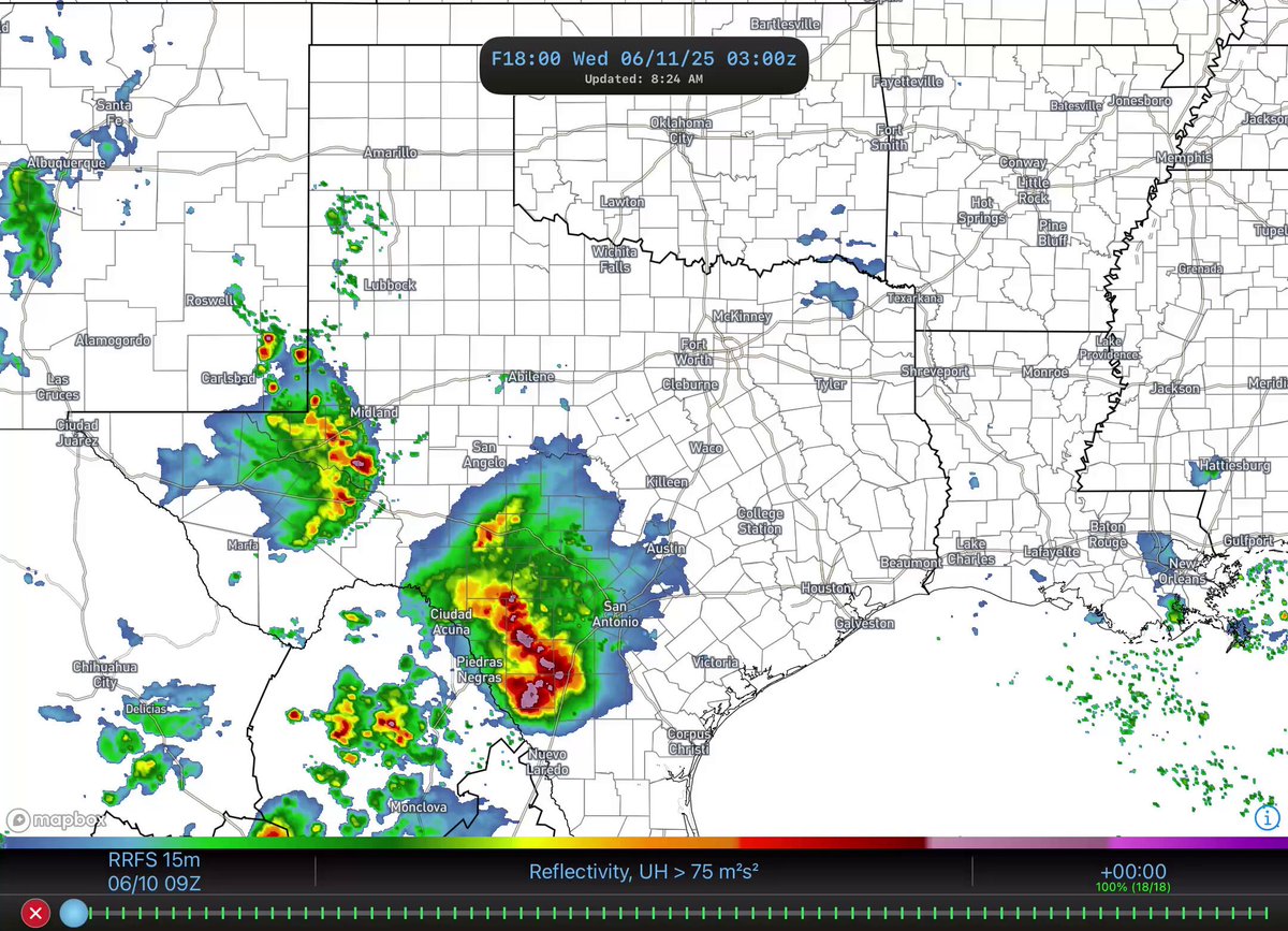
🔵IT’S ALL ABOUT THE DETAILS🔴. WeatherFront brings you more detail than any other weather app in a format that is sleek, smooth, and easy to use:. ⛈️ONLY source for sub-hourly (15 min) RRFS output.🔎Hyper local street names with several basemap options.📍Mesoanalysis soundings


5
7
49


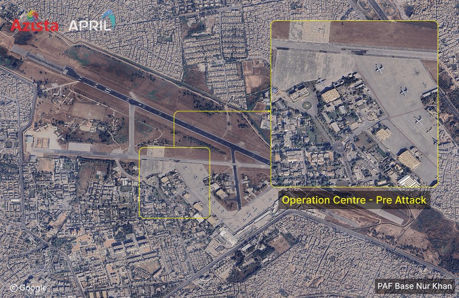
AFR imaged PAF Base Nur Khan at 11 May 2025, 10:12:00 UTC, indicating the damage incurred during #OperationSindoor. References: AFR Imagery (Panchromatic) - Built & operated by #Azista, India; Google Base Map; OSM Basemap; OSINT. #IndianArmy #IndianAirForce #AtmanirbharBharat


16
412
1K

Sorry to break it to you, but the person who sold you the "high resolution image" sold you a screenshot of an outdated basemap from a free Chinese mapping service - again, its from 2016, its from Pathankot & shows no damage, hope you can get a refund mate !


@detresfa_ So-called “neutral analyst” @detresfa_ is again selling narrative for Indians. He claims both images are from the same time but even a casual viewer can see they’re not. the right one shows vegetation, the left doesn’t it’s clearly burning marks…. Also, the left is from 2025.


80
404
2K
Have you checked out the new basemaps in WeatherFront yet?. You can pick unique basemap settings for each tab to suit your preferences. We think these new options will make your weather data viewing experience even better!
1
2
33

a neat little trick when lighting 2D objects is to use a hidden shadowcaster quad that copies the parent sprite as its basemap and rotates with the light!
12
69
768

Had an cute idea today and did it: Valentine's Day themed basemap 🥰 #mapbox #cartography #maps #NYC #ValentinesDay


0
3
71
WeatherFront Version 1.1 is now available in the App Store:. 🆓 3-day free trial of Advanced features.⛈️ Exclusive sub-hourly RRFS.📡 Reflectivity ground clutter filter.↔️ Customizable map pan speed.❎ Clear data tool.🗺️ Adjustable satellite basemap brightness. Update or download
13
14
78

🆕👀 As of today, WPC's medium range hazards outlook has a new look! This includes a new underlying basemap, transition from outline hazard areas to color-filled shapes, and label improvements. Attached is the latest update, valid 6/27-7/1.

12
100
404
One of the things I'm most excited about with our Raptor launch is incorporating aerial UAV data into a global basemap that fuses raw data from both satellites and drones into a living 3D representation of the Earth. The results are absolutely jawdropping.
0
0
19

Full HD satellite image of the Israeli airstrike on the Natanz Nuclear Facility in central Iran (13 June 2025) 📸 . You can pan around, zoom in and also create your own maps over this incredible imagery using the 🖌️ icon at the center of the screen.

11
11
44

WIP map of ISWAP and JAS areas of activity. Basemap is mostly done, almost happy with how it looks. Still working on accurately assessing the territory each group occupies. Right now it's sorta rough. Suggestions welcome.


0
0
4


💡 Try {ggspatial} to easily add scale bars, north arrows, and basemap layers to your ggplot2 maps. 🔗

0
21
95

Day 5: A Journey.A clever osprey who never goes hungry living beside a well stocked fishery 😁. Data from IUCN Red List, beautiful watercolour basemap - Wes Jones.#30DayMapChallenge #gischat#arcgispro#canva

0
2
35

Designers and developers use Mapbox Studio to create visually consistent, user-focused maps. Mapbox Studio makes it simple and intuitive to customize map features on the 3D basemap. You can apply specific brand color codes or adjust feature colors to highlight what matters most

0
0
6

Have you tried Felt's Extract tool yet?. Extract let's you build any boundary polygon (buildings, neighborhoods, counties – event states!) directly from the basemap – no external datasets needed. Pro tip: hold down the Shift key to select multiple polygons simultaneously!
1
1
15
Hyper-local road information overlaid on your weather data - WeatherFront equips you with a detailed basemap to enhance your spatial awareness. Find your street on WeatherFront and upgrade your radar viewing experience today:
2
1
18