Explore tweets tagged as #Webmapping

🌍 Nouvelle carte interactive des câbles sous-marins en fibre optique 💡.🔹 Données #OpenData.🔹 Vue dynamique selon la carte.🔹 Recherche & popup.🔹 Réalisée avec #LeafletJS.➡️ Testez-la ici : #DataViz #WebMapping #GIS #FibreOptique

0
1
7

It’s nearly lunchtime @foss4ge. Make sure to drop by our stand and say hello. We have experts in cartography, spatial data, web mapping, geocoding, JavaScript, and more!. #FOSS4G #FOSS4GEurope #foss4ge2025 #WebMapping #SpatialData


0
1
4


All great ideas from Bern: 10 ArcGIS Online New Year's resolutions: Here are ten ways to improve 2023 with ArcGIS Online! #arcgis #webmapping

0
2
4

0
8
19
Looking forward to tomorrow's #NFCC #DDaT conference. @Cadcorp is thrilled to support this event and demonstrate where #GIS and #WebMapping is helping #FireServices across the UK utilise data to inform decision-making and planning.

0
0
1


Our Customize tool now has a completely new experience for #map icons. Recolor on the fly or pick from over 200 new symbols. Try it out here: #Webmapping #Cartography
3
5
14
We're really excited to be at @UtilityWeekLive #UWL25 tomorrow. Come meet us on stand F24 where we will be exhibiting with @OrdnanceSurvey. Learn how OS data and the #OSNGD benefits utility companies and how to maximise its uses in #GIS and #WebMapping -

0
2
3
Check out the new icon management in MapTiler Customize! Recolor & resize your icons, or upload your own SVGs to really elevate your #maps to the next level. Read about it here: #WebMapping #Cartography
0
3
8
Upload spatial raster files directly to MapTiler Cloud! We’re making it easy to add your GIS data to web maps; try one of these key formats: GeoTIFF, GeoJPEG2000, MrSID, ECW. Find out more here: #webmaps #webmapping
0
3
8
Another busy day at @UtilityWeekLive #UWL25 - Pop by stand F24 to see @Cadcorp with @OrdnanceSurvey and learn how #SpatialData and the #OSNGD benefits #Utilities and how to maximise its uses in #GIS and #WebMapping

0
1
2
Our dark & light #map styles just got a serious #cartography update! Check out the new icons for points of interest on your favorite map: .Dark styles: .Light styles: . #WebMapping #Cartography

0
2
5

Finally finished client-side raster symbolizer on-the-fly with OpenLayers. It works like vector-tiles now. Next step is to add ColorBrewer functionality. #webgis #GIS #webmapping

0
0
3

Proud to announce that my team is now #certified as @CesiumJS developers! 😍🥳🙀. #FOSS4G #OSGEO @OSGeo @foss4g @opengeospatial #3DTiles #3D #gischat #geoserver #geonode #webmapping
0
8
22

🚀 GeoServer 2.27.1 is here!.A stable release packed with fixes, performance tweaks & improvements 🛠️. Great for production deployments!. 🔗 📋 Changelog: #GeoServer #GIS #OSGeo #FOSS4G #OpenSource #WebMapping

0
4
12
Social #housing provider and house-builder, @Alliance_Homes adopts #cloud #GIS to enhance data and business insights | @Cadcorp cloud hosted GIS & #WebMapping provides self-service access to property information and tenant service requirements #InthePress

0
0
1
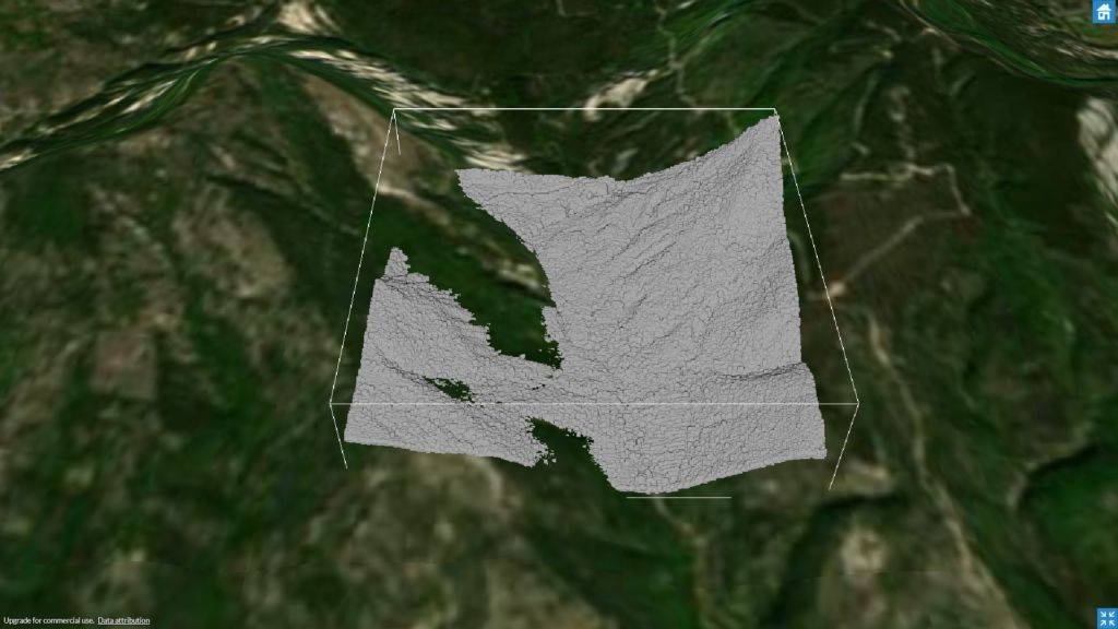
Want a 3D map in #React? Learn how to add #3D Terrain and beautiful #HillShading in our #MapsInReact YouTube video series: #WebMapping #Maps #JavaScript

0
3
3
Join the hunt! We’ve hidden #EasterEggs in some appropriately named places all around the world! Solve the clues and zoom in to reveal them. 🐇 🐣 🗿 🌷..#Easter #Webmapping

0
2
4