

Eric Bullock
@eric__bullock
Followers
1K
Following
1K
Media
17
Statuses
629
Remote Sensing, Geography, Python, Forest Monitoring, Google Earth Engine, Bluegrass.
Boston, MA
Joined October 2014
Check out this profile that @NASAEarthData did on me! In this photo I was using a tiny USB GPS, the entire Landsat archive for this area, and time series plotting in QGIS to try to understand the land use history of the ground I was standing on!

Deforestation is taking a toll on the Amazon and other areas of high #biodiversity. In our new Data User Profile, read how Dr. Eric Bullock uses Earth observation #data to explore the consequences of land use and land cover change in these areas. https://t.co/fSj7UDpBN4
4
8
53

Hello there! I'm proud to share a new wildfire paper in ERL - California had recent huge fires but tree loss rose much faster, relatively, than burned area. How much is the per-burned-area impact on tree cover losses rising, and why? Paper: https://t.co/ocG26QHqz6 1/7
1
5
36


Excited to see the launch of #geemap core at #GeoForGood23🚀. It has been a wonderful experience working with Googlers @jstnbraaten @_nschmitz_ and others for making this happen🧑💻. Check out geemap in the Earth Engine documentation 🗺️ https://t.co/bXqNbumkRw
6
44
238
🌍 Exciting news! 🎉 The #geemap Python package is now pre-installed on Google Colab. Huge gratitude to @_nschmitz_ and @jstnbraaten for their incredible work in bringing this to life 🌎 👉Try it out: https://t.co/WQumrohZur
#EarthEngine #geemap #geopython
11
83
469
Later this month, I will begin a new position with the US Forest Service as the Forest Inventory & Analysis national program manager. I'm continually inspired by & proud of the valuable work FIA does, and grateful for the opportunity to serve FIA & FIA users at a broader scale.

Please RT: Are you the next Deputy Program Manager for Forest Inventory & Analysis at USFS Rocky Mountain Research Station? Supervisory Biologist, GS-13/14 based in Riverdale, Utah; 1st-line supervisor of <10 staff & 2nd-line of ~80. Questions? Ask me! https://t.co/xTNIEOOrF0
20
10
181
🌍 Segment-geospatial v0.10.0 is out! It's time to get excited 🚀 It now supports segmenting remote sensing imagery with FastSAM 🛰️ GitHub: https://t.co/KUOhmJyArU Notebook: https://t.co/4DFqMPtpOm
#geospatial 🗺️ #segmentanything 🌄 #deeplearning 🧠
0
65
318

Get image data out of #EarthEngine client with the new Data Extraction API, optimized for machine learning and integrated with your Python or Javascript workflows. Learn more at

medium.com
By Nicholas Clinton, Earth Engine Developer Relations
11
58
209

Hello #Qgis and #RemoteSensing enthusiasts! The new version 23.7 of the #CCDC #Qgis plugin has Sentinel-2, and the process runs over #GoogleEarthEngine with more options. Check it out: https://t.co/DBT6ReXUzw
1
56
163
🌎The @BezosEarthFund has granted @stri_panama ForestGEO $12M for the @GEO_TREES Initiative supporting open-access to global satellite-based forest carbon data!🌍Learn more here: https://t.co/JEZhsnG6EU
1
13
45
geemap v0.24.0 is out with many new improvements 🚀 Check out the new #geemap web app developed using #Solara and devployed on #huggingface. Enjoy the interactive web app with bi-directional communication 👇 GitHub: https://t.co/Mo1M2rZWgq Web App: https://t.co/aQM10ENjfi
2
36
90

Wow, great techniques and example code to grab ➡️ Explore how to become a terrain artist with the ArcGIS Vector Tile Style Editor. Sr. Prod. Eng. and Cartographer Emily Meriam demonstrates Earth art styles and how you can create beautiful maps. #maps
https://t.co/QkmlPEPzfZ
0
2
3

Demonstration of CNN applied to large area time series land cover classification and more details at https://t.co/c3zt341n1U
2
21
118

High-resolution map of #tree cover in #SoutheastAsia using @NICFISatData and #Sentinel1 on #GEE. https://t.co/f9MA3krhm6 spoiler: the GEE code is open :) #EOchat #earthengine #remotesensing #forest
2
28
78

New paper with Dr. Kathryn Baer (USDA Forest Service) and @ucbdavid: https://t.co/r1Ah4MVenO Climate change is changing western US forests. Trees that prefer it cooler and wetter are dying, and their replacements are not more warm- or dry-preferring... 1/n
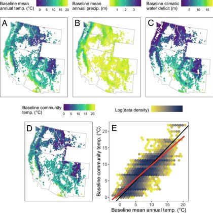
pnas.org
Climate change is driving widespread changes in ecological communities. Warming temperatures often shift community composition toward more heat-tol...
2
35
100

For #mondaymapday, check out this epic dataviz storytelling map that explores earthquakes around the world from 1900 to the present day, by @AtloTeam: https://t.co/rEbUTti7gl 🌏📖 #mapping #DataVisualization #gischat
1
5
19

Big news in Earth Observation: @planet to acquire @sinergise (the creators of the @sentinel_hub platform) continuing their strategy to go down the value chain - towards creating the "building blocks" to make EO accessible and usable. https://t.co/dv1aU4wpxG

businesswire.com
Planet Labs PBC (NYSE: PL), a leading provider of daily data and insights about Earth, today announced it has signed an agreement to acquire the business of ...
9
22
108

Synthetic Aperture Radar (SAR) is one of the most interesting technologies in Earth Observation, but not a well understood one @fortiain has written books, taught classes & decades of experience in academia & the industry on SAR Watch the full interview: https://t.co/M3RcCgAt1e
3
46
170

Today we have extended Norway's satellite program monitoring tropical deforestation! After 2,5 years it has become evident that public access to high res sat images leads to more effective rainforest protection. https://t.co/w2i1eOeiQu @NICFISatData
@Rainforest_RIN
1
29
77

And here's another key finding - conserving remaining ecosystems has more mitigation potential than wind power, and almost as much as solar Given everything else ecosystems do for us beyond climate mitigation, their conservation should be an absolute global priority 4/
18
297
933
Introducing a new #Python package called mapwidget - creating interactive 3D maps in a Jupyter environment using popular JavaScript libraries, such as #CesiumJS, #Mapbox, #MapLibre, #Leaflet, and #OpenLayers GitHub: https://t.co/uBcYChluTB
#geospatial #gischat #anywidget
24
298
1K