LARICS
@TheLARICS
Followers
582
Following
288
Media
120
Statuses
371
Los Angeles County's first regional, fully interoperable communications system dedicated to first and second responders. Built to Public Safety Grade.
Los Angeles, CA
Joined June 2013
It’s National Public Safety Telecommunicators Week and LA-RICS personnel befittingly attended LASD’s Dispatcher of the Year ceremony at the Sheriff’s Communication Center. We appreciate all the hard work dispatchers do! 🎧🚨📻
0
0
0

Mark your calendars! #ShakeOut on October 19th at 10:19 AM. Millions will be participating in the world's largest earthquake drill. Will you? Sign up at https://t.co/FccHj9f2ER and be part of it! #BePrepared
0
24
23

ROAD CLOSURE-HUNTINGTON DRIVE AND SANTA ANITA AVENUE - DUE TO A MULTI VEHICLE COLLISION - AVOID THE AREA.
3
7
6

If a power line falls on your vehicle or in the road, call 9-1-1 and stay inside until trained personnel can remove it. NEVER touch a downed power line or attempt to move it yourself. #CALFIRE #emergencypreparedness #HurricaneHilary
3
63
118

Traffic signal not working?? It automatically turns into a four way stop. Be alert!! Not everyone notices when the lights are dark and may fail to stop or yield to traffic in the intersection. STAY SAFE, STAY ALERT.
2
36
72

Currently closed until further notice due to storms: —San Gabriel Canyon Off-Hwy Vehicle (OHV) Area —Rowher OHV Area —Wildwood Picnic Site —Switzer Picnic Site + Los Angeles County has closed Chaney Trail, which limits access to Millard Canyon. #recreation
3
28
48

An Ocean Water Quality Rain Advisory is in effect until at least 9AM, Thursday, 8/24/23. Beach users should avoid water contact for at least 72 hours after significant rainfall.
41
265
663

Cooling Centers and other cool spots are open throughout LA County to offer relief from the heat during this period of #ExcessiveHeat. Visit https://t.co/vc6g1ASktu or your local city’s website for locations and resources to help #BeatTheHeat
0
10
19
🚧TRAFFIC ADVISORY🚧 @CaltransDist7 will begin clearing weeds and brush as a fire prevention measure on SR-27 (Topanga Cyn Blvd) from 9 AM to 3 PM on MON (6/26) at Cezanne Ave in #TopangaCanyon. Work involves lane closure, with alternating traffic. Expect delays. Details 👇
0
5
5
*State Route 2 (Angeles National National Forest* SR-2 (Angeles Crest Hwy) remains closed from Mt. Wilson Red Box Rd. to Vincent Gulch Rd. at least through the summer for winter storm damage repair. Photo: One of the rock slides along SR-2.
2
9
22
Today is the #SummerSolstice, marking the first day of #summer! Warmer temperatures mean drier vegetation and that can create the perfect conditions for a wildfire. Protect your home and family by taking the steps to be wildfire ready! Learn more at https://t.co/sWZPoZLdhV
0
37
61

Congratulations to #LACoFD’s newly promoted fire captains participating in the 27th Fire Captain’s Academy this week. The academy provides fire captains with leadership training, wildland incident operations training, and other fundamental skills needed in their new capacity.
0
6
35
#SmokeAdvisory: Angeles National Forest firefighters will be conducting a prescribed pile burn near Clear Creek Fire Station today. Smoke may be visible in La Cañada Flintridge, La Crescenta-Montrose, and nearby areas.
1
9
16
We are eagerly anticipating some sunshine and summer schedules. Be on the lookout starting this weekend for a lot more ocean lifeguards stationed throughout the @countyoflosangeles coastline as summer schedules begin to roll out.
0
4
17
#SmokeAdvisory: Firefighters are conducting two prescribed burns (planned fire) in the following locations: - Chilao Rx near Highway 2 - Liebre Rx near Liebre Mountain Smoke may be seen in nearby communities.
2
6
15
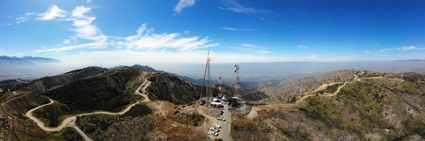
As with all LA-RICS systems, the NMDN system is resilient and redundant. It is designed to work in the robust and extreme environment of wildland firefighting. LA-RICS looks forward to making this service available to other users, as well. #LARICS
0
0
2
The NMDN services also include text messaging, form updates, GPS for the Automatic Vehicle Location (AVL) systems, and advanced mapping systems for the fire units in the field. The LACoFD is excited to use this next-generation technology provided by LA-RICS #LARICS
1
0
1
NMDN is seamlessly compatible with cellular broadband systems and provides critical data to wildland areas not covered by cellular carriers, and also in times of disaster when cellular services may be down #LARICS
1
0
1
LACoFD is primarily using the NMDN system to dispatch emergency call alerts and incident information from their CAD to all the fire stations and vehicles. #LARICS
1
0
1