
Shagun Garg
@ShagunGarg1511
Followers
389
Following
3K
Media
84
Statuses
739
https://t.co/oqGwZG3ZVh
Cambridge, England
Joined December 2019
📍New paper out! We explore how to detect floods in arid regions better using #Sentinel -1 SAR data. These areas are often ignored in global flood mapping, but our work highlights a new approach that improves detection by up to 50%! A thread 🧵 (1/n) https://t.co/SWFrhBjXUO
6
43
195
Presented our work on improving flood detection in arid regions last week at #LPS2025 in Vienna. Sharing the room with researchers I’ve looked up to for years. Grateful, inspired, and full of new ideas. Thanks to the conveners & the EO flood ppl. https://t.co/069WHEDzxO
0
0
10
Excited to share results on using #SAR #satellites for #flooddetection in #arid regions at #LPS in #Vienna! 📅 Wednesday, 25 June 📷 14:40–15:00 📷#RemoteSensing #Floods, #WaterBodyMapping, #InSAR, or #NatureBasedSolutions — come say hi! 📷
0
0
3
If you see two neighbors fighting, it's because an Englishman was there. - an Irish saying.

"THIS is the narrative the world should know." Ranveer Allahbadia holds up a picture of Osama Bin Laden during Piers Morgan's debate on the ceasefire with Pakistan. Watch in full 👇 📺 https://t.co/Qdt5aeDU8q
@piersmorgan | @BeerBicepsGuy | @BDUTT
0
0
1

PhD student Shagun Garg has been recognised as a Geospatial World Rising Star 2025, joining an international cohort of young professionals who are shaping the future of geospatial science and technology. @ShagunGarg1511
@GeospatialM
https://t.co/b8En9bs0QZ
0
2
5
It was a great experience to present my work at the Glasgow IR group @ir_glasgow. This talk was based on recently accepted papers -Quam (accepted at #WSDM2025) and SlideGAR (accepted at #ECIR2025) --done in collaboration with Sean MacAvaney @macavaney and Avishek Anand @run4avi
Today, Mandeep Rathee @rathee_mandeep from the L3S Research Center @l3s_luh is giving an #IRTalk entitled "Beyond Bounded Recall: Adaptive Retrieval using Query Affinity Modelling and LLM based Rerankers". Details: https://t.co/2priytqkw2
@GlasgowCS
@ir_glasgow
0
3
13
Can we use data from different sensors to improve crop yield production ? Give @fmenat14 RSE paper a read to find out!

More than one year ago we started with the idea of using adaptive (data-driven) fusion of multi-modal data for crop yield prediction (cc @_deepakpathak_). This is because each source of information might provide better crop-related information than others depending on each case
0
0
3

Just a 🧵 of required postings for my #AGU24 Photo Contest 📸 entries here, and also showcasing how beautiful my 🇵🇭 is. ⬇️
1
1
2

Introducing Varuna!🛰️Our first in-orbit demonstration of our SAR+AIS tech launching aboard ISRO's POEM platform. 9 months of hard work, innovation, & collaboration have led to this milestone. We’re just getting started!⚡️ Check out all the details here: https://t.co/9aWXW6uLYg
10
28
162

Thrilled to announce the release of #SARVey, an open-source #software for the #InSAR time-series analysis using both #Persistent & #Distributed scatterers in #Python. link to software -> https://t.co/q4jZudPOXS The paper describing the methodology-> https://t.co/90IC1A0GAJ
1
19
76
Sudden rain in the desert can turn dry sand into destructive floodwaters. Radar satellites often mistake these sandy landscapes for water. @ShagunGarg1511 has found better ways to detect floods in some of the world’s most overlooked areas. https://t.co/QZKttWYBpQ
0
4
7
📍New paper out! We explore how to detect floods in arid regions better using #Sentinel -1 SAR data. These areas are often ignored in global flood mapping, but our work highlights a new approach that improves detection by up to 50%! A thread 🧵 (1/n) https://t.co/SWFrhBjXUO
6
43
195
New Paper Alert! Are you interested in applying #Sentinel1-based #InSAR measurements for #infrastructure stability analysis? Then please see the paper led by our PhD student Andreas Piter about challenges and opportunities in this regard. https://t.co/90IC1A0GAJ
0
5
16
Interesting..

Spain destroyed more than 256 dams between 2021 and 2022, "to restore the natural course of rivers", in order to comply with UN Agenda 2030. But no, the flooding is a result of "climate change". 🤡 https://t.co/0q3avlgDy8
0
0
0
In this forum article led by @MahdiMotagh, a team of scientists discusses the critical role of a data-driven #nexus approach in understanding hazards related to #landslides & #land_subsidence Link to paper-> https://t.co/NhvfLQBGL2
@Land_Subsidence
@ShagunGarg1511
@FraCigna
0
4
10

Hold on tight. During the ride. - Deutsche bahn. Not just in bus. Also in life.
0
0
3
For the roi, which is water (in red), the time series from #sentinel2 shows a lot of fluctuations until Dec 2021. I tried other similar areas and saw a drastic difference in the NDVI before and after 2022. Any ideas why? Am I missing some atmospheric corrections?
1
1
0
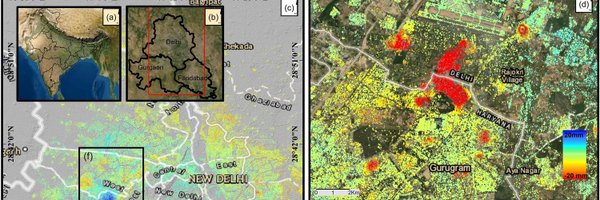
Delhi #YamunaRiver #pollution has been making headlines due to the visible foam in the water. This is derived from @ESA_EO #sentinel2. Blue areas represent relatively normal water, while the orange-red regions show highly polluted areas where chlorophyll levels spiked. 🧵
0
0
0
New paper alert! In this new study, led by @ShagunGarg1511-PhD student from @Cambridge_Uni & #HIDA scholar at @GFZ_Potsdam, we have shown how potentials of #SAR data can be exploited for accurate flood mapping in arid regions link--> https://t.co/62yIvlphaw
0
3
15
This is at 5-day intervals. Seems like the situation is getting a little better except the #Delhi #UP border (Where the steep curve is in the middle). @DelhiJalBoard @CGWB_CHQ @AamAadmiParty @ESA_EO @isro
0
0
0