Mahdi Motagh
@MahdiMotagh
Followers
2K
Following
7K
Media
164
Statuses
1K
Prof. in Radar Remote Sensing @GFZ_potsdam @UniHannover, interested in remote sensing for earth system science and engineering. Tweets my own
Germany
Joined July 2014
It is time for us in Germany to say goodby to X. Thank you for following us.
We join those universities and research institutes in Germany to discontinue our activities in this platform. Thank you for following us over the last yrs. You can find updates about our reseach in the following address: https://t.co/6MAdBAQfts
0
0
5
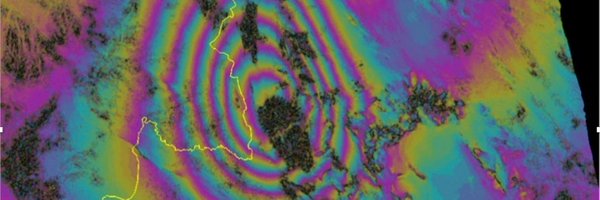
Ministry of Natural Resources in China releases the first LuTan-1 (L-band SAR satellite)-based earthquake displacement field and fault slip model associated with Jan. 7, 2025 Mw 6.8 earthquake that occurred in Dingri County, Shigatse City, Tibet.
0
18
37
In a new study together with colleagues in the US, we used our newly developed open-source #SARvey software to analyze structural instability of coastal buildings in #Miami . link to the article --> https://t.co/7eT0lGT0Pt link to SARvey --> https://t.co/q4jZudQmNq
0
2
8
Thrilled to announce the release of #SARVey, an open-source #software for the #InSAR time-series analysis using both #Persistent & #Distributed scatterers in #Python. link to software -> https://t.co/q4jZudPOXS The paper describing the methodology-> https://t.co/90IC1A0GAJ
1
19
76
Analysing complex #SAR #echoes associated with #powerlines is important for inspection management applications. In this paper, we proposed a novel tracing method to analyze #multireflection effects of such objects in #TSX data. @WHU_1893 link to paper -> https://t.co/BjEkba8dtf
0
1
10
In this forum article led by @MahdiMotagh, a team of scientists discusses the critical role of a data-driven #nexus approach in understanding hazards related to #landslides & #land_subsidence Link to paper-> https://t.co/NhvfLQBGL2
@Land_Subsidence
@ShagunGarg1511
@FraCigna
0
4
10
New paper alert! In this new study, led by @ShagunGarg1511-PhD student from @Cambridge_Uni & #HIDA scholar at @GFZ_Potsdam, we have shown how potentials of #SAR data can be exploited for accurate flood mapping in arid regions link--> https://t.co/62yIvlphaw
0
3
15
New Paper Alert! Are you interested in applying #Sentinel1-based #InSAR measurements for #infrastructure stability analysis? Then please see the paper led by our PhD student Andreas Piter about challenges and opportunities in this regard. https://t.co/90IC1A0GAJ
0
5
16
At @UniHannover we are proud for our internationalization and be inclusive for different cultures. A memorable night for 75th anniversary of the #IPI institute with amazing performance of traditional Indian dances from a member of our #RADAR group @Ritushr80919287 from 🇮🇳
0
2
10

📍New paper out! We explore how to detect floods in arid regions better using #Sentinel -1 SAR data. These areas are often ignored in global flood mapping, but our work highlights a new approach that improves detection by up to 50%! A thread 🧵 (1/n) https://t.co/SWFrhBjXUO
6
43
195
An Interactive map of #land #subsidence in #Iran, developed in a collaboration between @UniHannover & @GFZ_Potsdam
https://t.co/ppDtvGwV4v Link to paper-> https://t.co/elLDF0n5KW link to Zenodo -> https://t.co/ISJSK449fx
@Land_Subsidence
@UNU_FLORES
@MahdiMotagh
@Mahmudhh
0
3
12
Our recent work for #land #subsidence in #Iran that was published earlier this year by @Mahmudhh & @MahdiMotagh in @ScienceAdvances was featured in @guardian
@Land_Subsidence
@GFZ_Potsdam Link to Guardian--> https://t.co/BQzaRldQAi

theguardian.com
Subsidence caused by groundwater depletion beginning to affect key infrastructure such as airports and roads
0
1
3
New study on #joshimath using #SAR #remotesensing by @GfzRemote research group https://t.co/mr9zJlpPSl Congratulations to Wandi Wang, Prof. @MahdiMotagh and others

link.springer.com
PFG – Journal of Photogrammetry, Remote Sensing and Geoinformation Science - This paper investigates the spatiotemporal characteristics and life-cycle of movements within the Joshimath...
1
3
10
New Paper Alert! In this publication at the #Journal of #Hydrology, led by @SwiftTang, we have shown how decades of effective #water management stategies in northern #China led to reversal of land #subsidence
@Land_Subsidence
@MahdiMotagh Link--> https://t.co/1qtOl8x1Tt
0
2
4
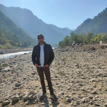
2nd day of expedition in 🇹🇼 . @Mahmudhh, @ericrivs & @MahdiMotagh visiting a susidence area in 🇹🇼 . @Mahmudhh makes an experiment for creating a hole on a soil fully saturated with water.
0
3
10
@Mahmudhh, @ericrivs, @MahdiMotagh and Sigrid from our group in a visit to 🇹🇼 for scientific cooperation with National Taiwan Normal University to investigate hazards related to #subsidence and #landslide in 🇹🇼 @Land_Subsidence
0
2
9
New Research Alert! Zelong's paper to investigate #postseismic #creep (#afterslip) following the 2017 Mw 7.3 Sarpol-e Zahab #earthquake in #Iran using #InSAR & Finite Element Modeling just published at Seismological Research Letters https://t.co/r3cI1laUuV
0
3
11
0
2
9

Dr. Mahmud Haghshenas Haghighi, Leibniz Universität Hannover, presents his lecture titled "SAR / InSAR for Geohazards" in UYGU Summer School 2024 in Istanbul Technical University. @Mahmudhh @GfzRemote @MahdiMotagh @UniHannover @GRSSTURKEY @IEEE_GRSS
0
2
6
The IEEE GRSS Turkey Chapter Summer School, UYGU 2024, with the theme of "Remote Sensing for Disaster Management" will be held in Istanbul Technical University, Turkey, between the dates of June 10 - 12, 2024. @IEEE_GRSS
@GRSSTURKEY @itu1773
https://t.co/OrzzwkaklB
0
6
13