
VALUABLES Consortium
@RFFvaluables
Followers
271
Following
128
Media
67
Statuses
300
Cooperative agreement between @rff and @NASA. Measuring how #EarthObservations benefit people and the #environment when we use them to make decisions.
Washington, DC
Joined October 2018
Our Value of Science explainer series introduces key terms, concepts, and methods useful for measuring how #EarthObservations benefit people and the #environment when we use them to make decisions. Follow along for more info! 🌍 #ScienceTwitter #EconTwitter
2
2
21

#ImageOfTheDay The worrisome #drought in South America continues #Agriculture 🌾 is heavily affected: the harvest could drop 📉 by 5⃣0⃣% in #Argentina in 2023 ⬇️The #Parana River basin 🇦🇷🇺🇾 in ↙️ January 2022 and ↘️ January 2023, as seen by #Copernicus #Sentinel3 🇪🇺🛰️
12
101
228
On Monday, we celebrated 5️⃣ years of the VALUABLES Consortium, an @rff & @NASA partnership. Read the thread below for a brief recap of highlights from the event 👇

LIVE 📹🔴 @RFFvaluables Capstone Celebration! 🛰️🎉 Join us for a celebration of the VALUABLES community, spotlighting consortium results and looking ahead to the future of Earth observations informing decisions. Tune in:
0
1
2
𝑅𝒮𝒱𝒫 𝒩𝑜𝓌 On Dec. 5, we’re looking ahead to the future of socioeconomic assessment for Earth observations with @rff, @NASA, and @NASAEarthData. Join us:
0
0
0
For over 5️⃣ years, @rff & @NASA have collaborated on the VALUABLES Consortium, measuring the societal value of using Earth observations in decisions. Join us on Dec. 5 as we showcase what we’ve learned and where the field is going. ⏩ https://t.co/u0mESmcnhK
0
0
4
That’s all for now! Thank you for following along. This webinar was recorded, and a video is available here:
rff.org
0
0
0
@rff @HannahDruck There’s also a need to connect research to real-life issues. “We, individually as researchers, cannot be the sole people defining those metrics of success, because of the utmost importance are the communities actually experiencing these issues,” @ItsUfuoma (@medialab) said.
1
1
1
Overall, for work related to environmental justice, “There’s a role for satellite data in accountability metrics that give teeth to environmental goals.” said @RFF’s @HannahDruck.
1
0
0
@ItsUfuoma @medialab On how the @USDA has used satellite data: “A lot of our work in this space has been looking at what has been planted on fields when and where … and then looking at the conservation-program aspects of that data,” Kelly Maguire (@USDA_ERS) said.
1
0
0
“What I want to really look at is the advocacy realm—a lot of organizing in environmental justice is done at the grassroots level, by communities on the front lines,” @ItsUfuoma (@medialab) continued.
1
0
0
This data also can complement grassroots measures, according to @ItsUfuoma (@medialab). “There’s identifying that there’s a disparity, and then there’s understanding the legal and political implications of this information,” she said.
1
0
0
@yusukekuwayama @UMBCPubPolicy While laws can create standards for environmental justice, satellite data can be a tool to make sure legislation turns into action via “actually monitoring and enforcing environmental law,” said @RFF’s @HannahDruck.
1
0
0
Kicking off the event, @yusukekuwayama (@UMBCPubPolicy) asked, “Our role as scientists often is to improve information, improve data, and improve modeling. So, if that’s the nature of our role, how can we maximize our impact in that area [of environmental justice]?”
1
1
1
How can satellite data help advance #EnvironmentalJustice? On Monday, a panel of experts from @RFF, @medialab, and @USDA_ERS convened to answer this question. Open this thread to uncover key takeaways from their discussion. 🧵
1
1
2
@wxpizza That’s a wrap! Thank you for following along. This recording of the webinar was recorded, and a video will is available here:
rff.org
A VALUABLES webinar examining how scientists and decisionmakers can improve their engagement to inform decisions and increase the value of satellite information
0
0
0
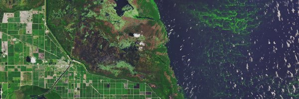
Harmful algal blooms (HABs) are indeed harmful, but the future isn’t all bloom and gloom when it comes to HABs. This study looks at how satellite information can facilitate an early-warning system for HABs and lead to savings in healthcare costs.
0
0
0
Near-real-time satellite imagery of the Amazon rainforest provides an effective tool to monitor deforestation. 🌳 This working paper provides an estimate of the deforestation avoided as a result of satellite technology. 🧐
0
0
0