
Next-Gen Weather
@NextGenWeather
Followers
1K
Following
2K
Media
2K
Statuses
4K
Official homepage for Next-Gen Weather, a team made up of the next generation of weather enthusiasts! | For questions or concerns, DM @Isaacwx_ | Application🔗⏬
Joined February 2023
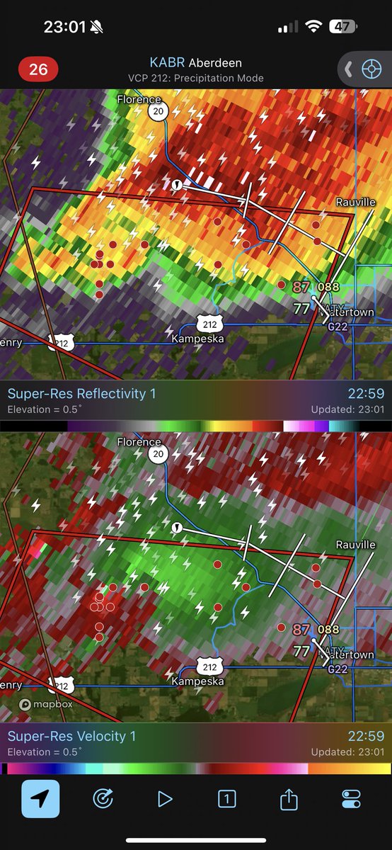
INTENSE TORNADO ON THE GROUND NEAR WATERTOWN SD, Via @BrandonCopicWx , THIS IS A PARTICULARLY DANGEROUS SITUATION TAKE SHELTER NOW in Kampeska and Watertown SD!!

0
2
4
A tornado is on the ground near Sauk City/Prairie Du Sac, heading toward Merrimac and Lodi, WI. Seek shelter NOW is SE Sauk County, NW Dane County, and SW Columbia Counties in Southern Wisconsin!

0
0
1
This PDS Tornado Warning has been extended for Northeastern Iowa, Southeastern Sauk, and Northwestern Dane Counties in Southern Wisconsin. Seek shelter NOW in Mazomanie, Roxbury, and the Sauk City/Prairie Du Sac City!
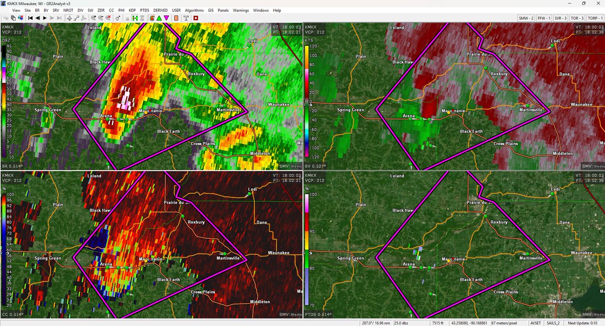
PDS Tornado Warning in effect for NE Iowa County in SW Wisconsin. A tornado is on the ground 7 miles SW of Mazomanie, moving toward the Mazomanie, Sauk City, and Black Earth area. Take Shelter NOW!

0
0
4
PDS Tornado Warning in effect for NE Iowa County in SW Wisconsin. A tornado is on the ground 7 miles SW of Mazomanie, moving toward the Mazomanie, Sauk City, and Black Earth area. Take Shelter NOW!
0
0
2
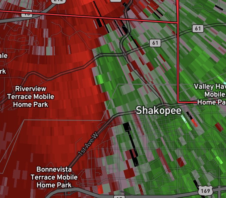
New tornado north of Shakopee!
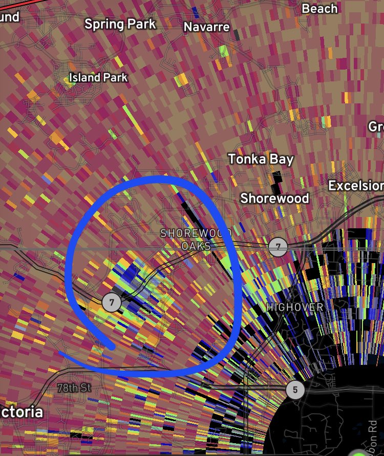
TORNADO Near the KMPX Radar, just south of Tonka Bay MN!!. Take shelter Chanhassen, Shorewood, and Victoria MN!! A tornado is very close to radar, moving 20 MPH ENE!
0
0
1
TORNADO Near the KMPX Radar, just south of Tonka Bay MN!!. Take shelter Chanhassen, Shorewood, and Victoria MN!! A tornado is very close to radar, moving 20 MPH ENE!
0
0
5
RT @YoungWx07: Very defined wall cloud now on the Castlewood, SD storm. 6:23 pm @NWSAberdeen @NextGenWeather #sdwx


0
4
0
RT @YoungWx07: Rapidly developing supercell with a possible funnel/wall cloud near Castlewood SD @NWSAberdeen @NextGenWeather #sdwx 6:10 pm….
0
7
0
A tornado appears to have just hit a rest area along I-94, just east of Bismark, ND. Take shelter NOW in Southeastern Burleigh County, ND!


0
0
0
A tornado is on the ground 6 miles north of Bismark, ND, moving SSE toward the NE section of the city. TAKE SHELTER NOW!

0
0
1
Strong tornado on the ground, 3 miles west of Temvik, ND. This tornado is in the occlusion process, and is likely nearly stationary. THIS IS A PARTICULARLY DANGEROUS SITUATION, TAKE SHELTER NOW!

0
0
0
OBSERVED Tornado warning w/ a potentially stronger tornado for Houston and Sheldon MN. Moving ENE at 25 mph; potentially on the weakening trend: But still extremely dangerous!!.Take shelter!

0
0
1
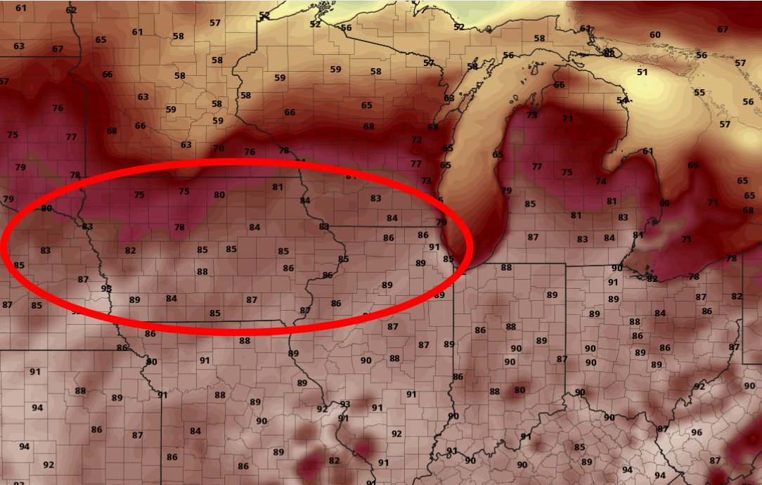
Many severe thunderstorm warning (orange boxes) across a wide swath of the central and eastern US today! Noticeably, these mainly fall around the edge of our ridge, which is overspreading the south-central US.

0
0
0
We'll be looking at some lower-end severe potential over the next few days across the northern portion of our ridge that is currently overspreading much of the central US. This ridge will continue to lead to abnormally high heat indexes for the next few days!
0
0
0
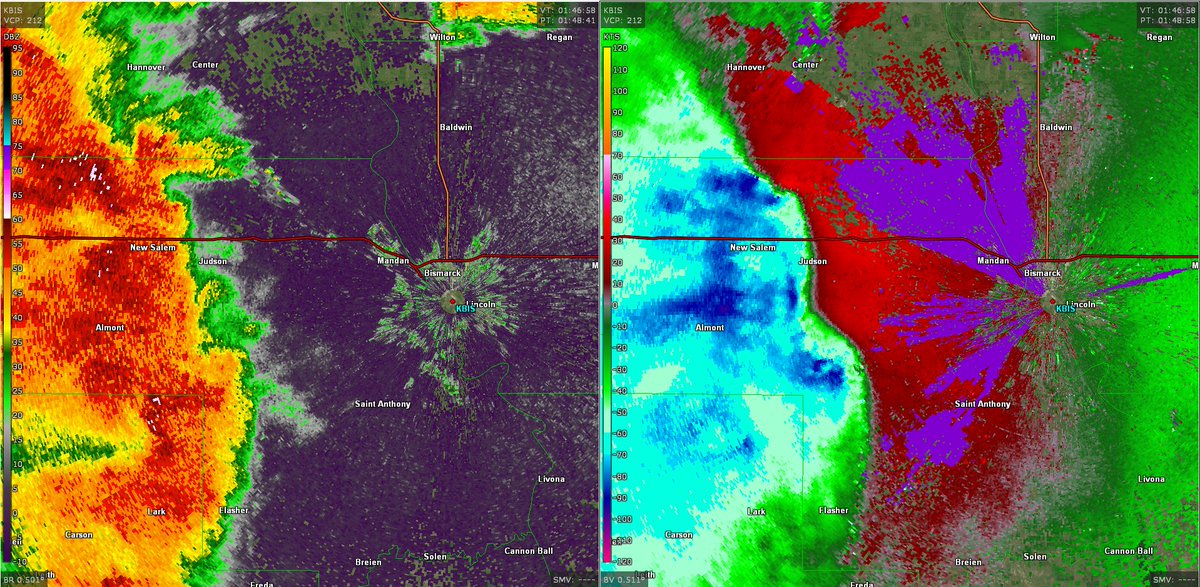
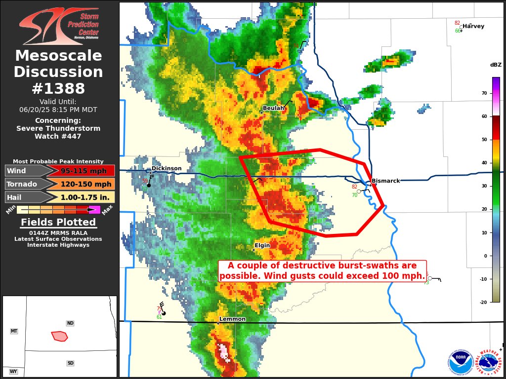
MULTIPLE areas of 100+ MPH winds are overtaking North Dakota due to an unusually potent Wake Low and RIJ behind the current MCS.
0
0
1
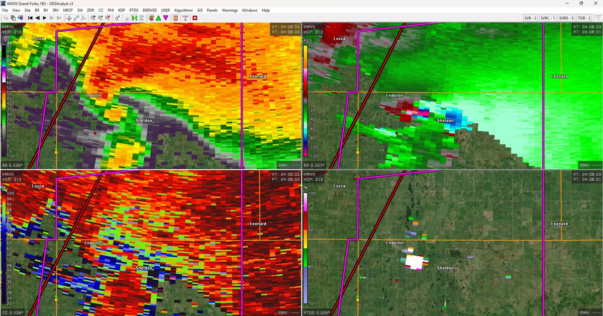
THIS IS A PARTICULARLY DANGEROUS SITUATION, TAKE COVER NOW! TORNADO IS CURRENTLY CROSSING ND-46 3 MILES EAST OF ENDERLIN, ND.
Strong/intense tornado on the ground, currently located between Enderlin, ND and Sheldon, ND. Those in northeastern Ransom, and southwestern Cass Counties, North Dakota need to seek shelter NOW!
0
4
3
Strong/intense tornado on the ground, currently located between Enderlin, ND and Sheldon, ND. Those in northeastern Ransom, and southwestern Cass Counties, North Dakota need to seek shelter NOW!
0
1
1
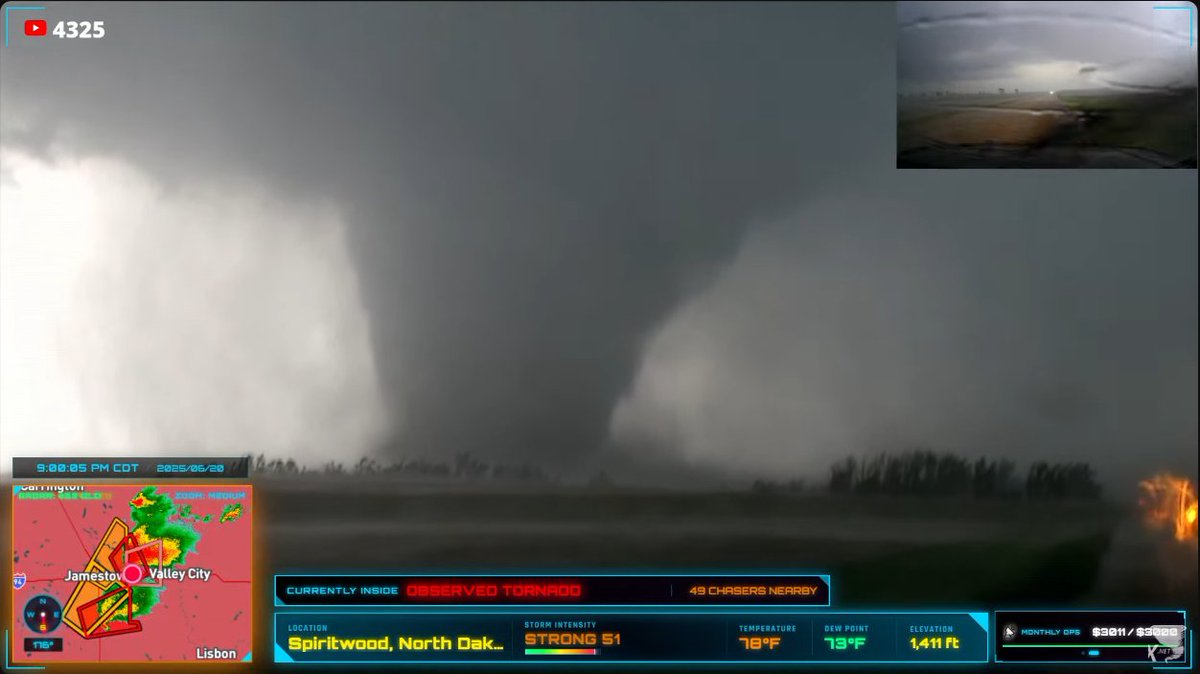
Large and intense tornado on the ground east of Spiritwood, ND, moving into Barnes County, ND. This is clearly an extremely dangerous tornado. THIS IS A PARTICULARLY DANGEROUS STITATION, TAKE SHELTER NOW!


1
1
9
BISMARK NORTH DAKOTA: An intense line of severe storms is imminent, with wind gusts possibly as high as 115 mph, which is equivalent to an EF-2 tornado, or a category 3 hurricane. Treat these storms as if a tornado is on the way, and follow all official warnings.

0
2
2