
NWS Sioux Falls
@NWSSiouxFalls
Followers
63,313
Following
275
Media
33,072
Statuses
53,028
Official Twitter account for the National Weather Service in Sioux Falls. Details:
Sioux Falls, SD
Joined June 2012
Don't wanna be here?
Send us removal request.
Explore trending content on Musk Viewer
Drake
• 2037755 Tweets
Kendrick
• 1792492 Tweets
Madonna
• 335029 Tweets
Star Wars
• 307108 Tweets
ANOTHER ONE
• 149167 Tweets
Not Like Us
• 139703 Tweets
こどもの日
• 139207 Tweets
Flamengo
• 110174 Tweets
Copacabana
• 90402 Tweets
ケンタッキーダービー
• 63105 Tweets
フォーエバーヤング
• 53296 Tweets
#precure
• 46001 Tweets
Kdot
• 43927 Tweets
子供の日
• 41989 Tweets
De La Cruz
• 38976 Tweets
#仮面ライダーガッチャード
• 32233 Tweets
#UFC301
• 28641 Tweets
Minnesota
• 25983 Tweets
#KentuckyDerby
• 25008 Tweets
プリキュア
• 24148 Tweets
#ブンブンジャー
• 23588 Tweets
Forever Young
• 22624 Tweets
ゴージャス
• 20987 Tweets
Timberwolves
• 20330 Tweets
設営完了
• 20197 Tweets
カグヤ様
• 19905 Tweets
Bruins
• 18037 Tweets
Mystik Dan
• 17365 Tweets
テーオーパスワード
• 15502 Tweets
Anthony Edwards
• 15465 Tweets
Bruno Henrique
• 12855 Tweets
Gerson
• 12430 Tweets
CERTIFIED LOVER BOY
• 11154 Tweets
ジャグラー
• 10832 Tweets
Sierra Leone
• 10633 Tweets
唐十郎さん
• 10513 Tweets


⚡️⚠️ A little "heads up" about Monday. While still a couple days out and still uncertain on exact timing, there will still be a threat for a few severe storms, especially across eastern NE/western IA by later afternoon and evening. Keep up on the latest forecast!

0
0
10
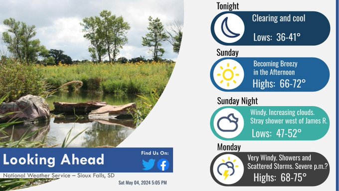
Enjoy the quiet weather through Sunday, although southerly winds will increase later in the day. Monday will be quite windy, especially ahead of the next round of showers/storms. A few severe storms will be possible on Mon. afternoon/evening, so keep up with the latest forecast.
0
1
3
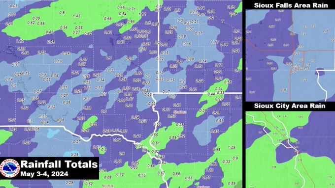
Here's a look at the rainfall totals Friday night into Saturday.
For a text listing of reports view the link:
1
0
3
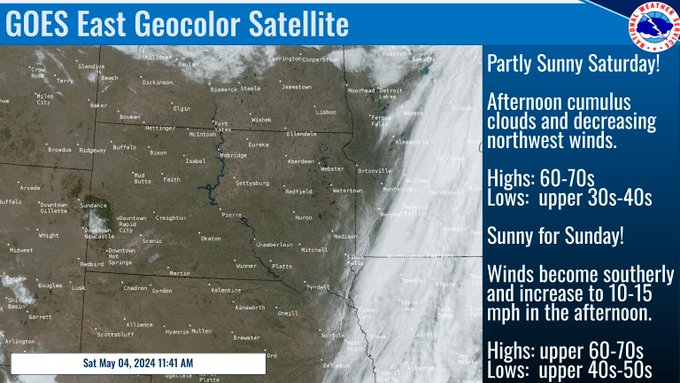
Sunny skies & seasonably warm temperatures this weekend will help to dry things out after our recent rains. In this satellite image, we can see the remnants of the rain from last night moving off to the east over IA & MN. We also see cumulus clouds popping up all over the region.
0
2
4
With rain overnight and decreasing winds, we're seeing patch fog develop on satellite and some area DOT cameras. If you have travel plans early this Saturday morning, keep these tips in mind!

0
2
1
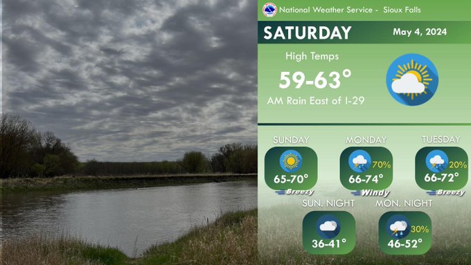
Lingering rain exits east of I-29 by mid morning. Clouds decrease today with cooler temps. Shower/storm chances return late Sunday night. Confidence is low but a few storms Monday afternoon/evening could be strong to severe. Stay weather aware!
0
2
2
Saturday 12:45 AM - Radar Update
Rain continues moving east early this morning, with locally moderate to brief heavy rain. If traveling tonight, be aware of localized ponding on roadways - especially across northeastern NE, far southeastern SD, and into northwestern IA.
0
0
5
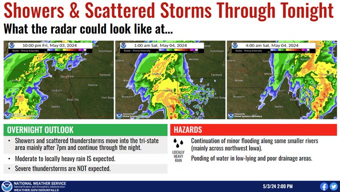
More rain is on the way tonight.
Here's a radar progression into Saturday morning.
Thankfully, no severe weather is expected, with the highest rainfall amounts approaching an inch in Northwest Iowa.
2
5
17
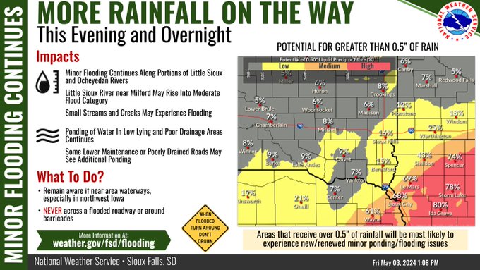
515 pm UPDATE - trends have come around to favor a greater potential for rainfall of 0.50" or more in areas generally south/east of the Sioux Falls area.

0
4
10
Showers and scattered thunderstorms are expected this evening and overnight. Moderate to locally heavy rain is expected with a continuation of minor flooding along some smaller rivers and ponding of water in low-lying and poor drainage areas.
0
3
17
Another round of rain is on the way later today and overnight. While amounts generally remain near/less than 0.5" for most, rainfall totals closer to an inch are possible across portions of NW IA. This may renew minor flooding/ponding issues where higher amounts occurs.
0
1
11
Minor flooding continues along portions of the Little Sioux and Ocheyedan Rivers in NW IA with additional rain chances over the coming days. The latest river stages, forecasts, and information can be found at

0
1
3
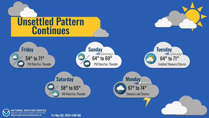
Unsettled weather pattern continues with near normal temps. Dry much of today, with rain chances increasing from west to east this afternoon. Mostly dry this weekend, before rain and storms return late Sunday into early next week.
0
1
5
Got outdoor plans this weekend?
Beware that another round of rain showers will be pushing through Friday afternoon through Saturday morning, but the rest of the weekend should be dry.
Here's a look at when showers will start and end at a handful of cities in the tri-state area.

0
2
7
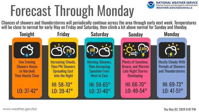
After a few evening showers along U.S. 14 from Huron to Marshall dissipate, tonight will be mostly clear, with temps falling into the upper 30s to low 40s overnight.
Periodic showers and thunderstorms continue Friday evening thru Monday, with near to slightly above normal temps.
1
3
7
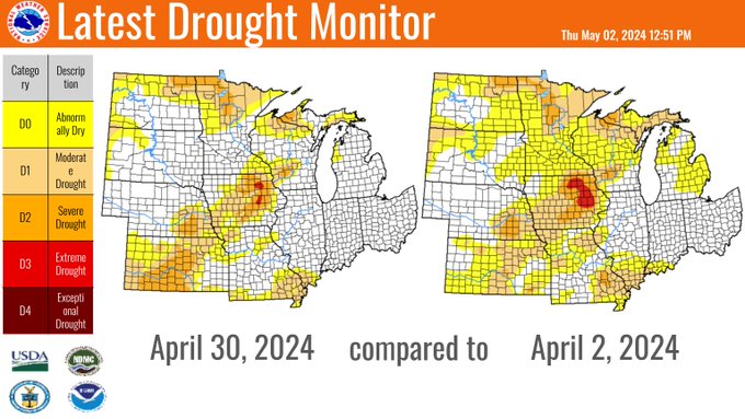
Here is the latest from the drought monitor. In the past month we have shown widespread improvement to drought conditions across the region. There are more chances for rain in the upcoming week which could lead to further improvements.
0
9
63
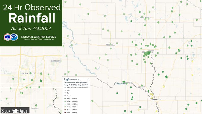
Here are two maps comparing 24 hour rainfall totals. The shaded map is the totals based off radar estimates. The map with points is CoCoRaHS rain gauge reports. They are fairly close with a few outliers in the gauge map.
How much was in your rain gauge? Let us know!

7
3
11
Moderate to heavy rain continues across northwest IA and southwest MN early this morning, and some locations have received an 1" to 1.5" of rainfall overnight. Be cautious of ponding on roadways if commuting this morning. Look for this rain to end from west to east through 9 AM.
1
1
18
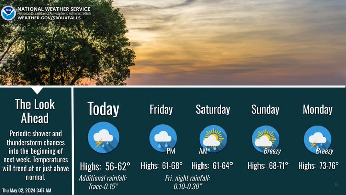
Although shower coverage will diminish today, unsettled conditions will linger into the beginning of next week. Temperatures will be in the 50s and 60s today, then into the 60s and 70s for Friday through Monday.
0
0
8
Current radar shows heavier showers lifting out northeastern NE. These heavy showers will track across northwestern IA during the late night hours, and could bring rainfall of 1 to 1.5" by Thursday morning. This could lead to ponding of water across the area.
0
0
10