
MyRadar Weather
@MyRadarWX
Followers
127K
Following
11K
Media
17K
Statuses
33K
Keeping you ahead of the storm since 2009. Download for FREE!
Orlando, FL
Joined July 2012
🆕 Just launched: Map Tools in MyRadar!.✏️ Draw.📏 Measure.🔍 Inspect.All FREE and available NOW!.Start exploring more with every tap 👉
0
8
50
A confirmed large and extremely dangerous tornado is located near Mazomanie, Wisconsin, or 12 miles southwest of Sauk City. Moving NE at 30 mph. Seek shelter NOW!. Left plot depicts a bit of a doughnut hole, or “bounded weak echo region,” on radar. Tornadic updraft lifting rain!


0
7
16
⛈️A few strong thunderstorms with torrential rains are likely across the DMV this afternoon. Isolated damaging gusts are also possible. Localized flooding may be a concern in urban areas. MyRadar meteorologist @MatthewCappucci has an update.
0
0
7
⛈️Scattered strong to severe thunderstorms are likely Wednesday across portions of Wisconsin, Illinois and western Michigan. 🌪️Damaging winds are the main hazard, though some hail or an isolated tornado can’t be ruled out. Meteorologist @MatthewCappucci has an update.
0
3
10
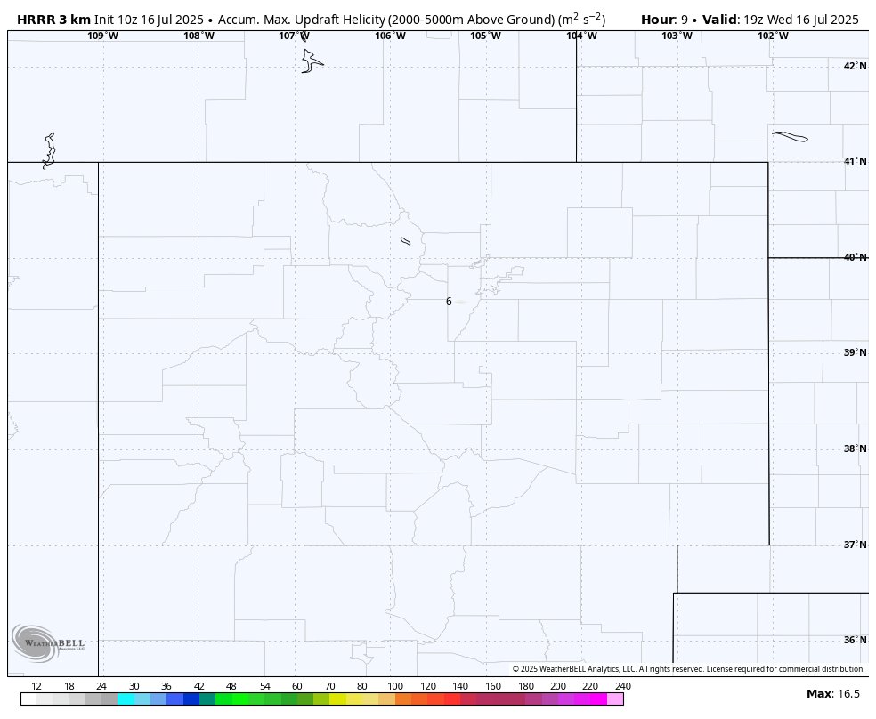
⛈️A few rotating storms are possible over the High Plains of Wyoming and Colorado today, including along the Interstate 25 corridor. Large hail up to golf ball size and an isolated tornado are possible. Meteorologist @MatthewCappucci has an update.
0
0
9
COLORADO/southeast WYOMING gang – looks like a rough night across the High Plains today!. Severe weather risk for the I-25 corridor from Colorado Springs to Denver and Boulder and up toward Fort Collins. Laramie and Cheyenne are in the zone too. A westward-moving front has


1
4
13
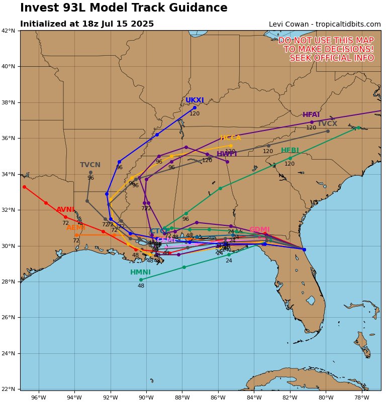
🌀There is still a medium chance that Invest 93L could develop into a tropical depression or storm. That said, it’s been meandering closer to land and may not have long over the warm Gulf waters. MyRadar meteorologist @MatthewCappucci has a Wednesday midday update.
1
0
11
WEDNESDAY severe weather threat for northern Illinois, southern Wisconsin and western Michigan. As of mid-morning, we had a swirl visible in surface observations west of Mason City, Iowa. That's an MCV, or a mesoscale convective vortex – like a miniature low pressure system


0
2
9
GOOD NEWS with Invest 93L! Its center is over LAND right now – midway between Apalachicola and Tallahassee. As long as it stays over land, it can't strengthen. Winds are only flowing into the system at 7-15 mph, meaning it isn't inhaling much air. That's a sign of how weak the

0
6
39


Wow! Wild shot from a storm on Friday. This is the “outflow boundary,” or leading edge of cool air exhaust undercutting warmth/moisture ahead of storms. That creates a shelf cloud. Great capture, Lane!.

Check this out from illinois earlier!! absolutely STUNNING🥹.@JimCantore @MatthewCappucci @weatherchannel @ABC7Chicago .this is Taylor Ridge, Illinois. at 16:30 ish
0
3
23
EF2 damage to a home! Kudos to @NWSGJT for conducting a full damage survey. Look at the roof – while the "bones" of the structure remained intact, much of the roof is missing, leading to an EF2/122 mph rating. Only the third EF2+ tornado in Utah in the 2000s!
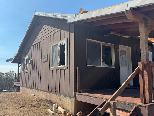
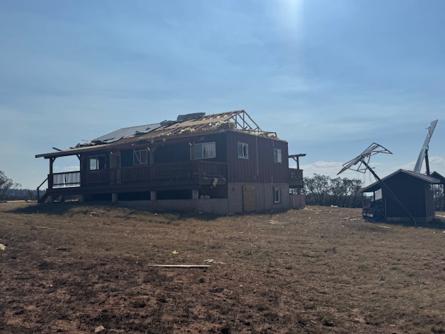

BREAKING: Incredibly-rare FIRE TORNADO in Utah officially rated an EF2 vortex by the National Weather Service! 🔥. The FIRE TORNADO had winds up to 122 mph, making it only the third EF2+ tornado to occur in the state of Utah since the year 2000. This was associated with the
0
0
15
Invest 93L is making its way across northern Florida this evening and spawning tropical thunderstorms as far west as Pensacola Beach, Florida. @JordanHallWX is in the field with an update! .#flwx #tropicalweather #wxtwitter
0
0
12
GOOD news with regard to Invest 93L (our Florida system)… the Tuesday evening models have shifted north in their projected tracks for the storm. Why is a track closer to shore good news? It limits the system’s time over water AND keeps it in closer proximity to mid-level dry
1
3
15
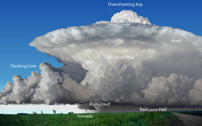
Most people focus on the tornado, but it’s just a tiny part of the storm. Supercells can tower 50,000 feet high and span miles across. That funnel? Often less than 1% of the storm’s size. The real power is hidden in the massive rotating structure above.

All the various parts of a supercell thunderstorm. Cool, eh?
0
6
20
RT @CollinGrossWx: The Weather Prediction Center has put out a rare Day 4 Moderate Risk of flash flooding for south-central Louisiana. #Inv….
0
14
0
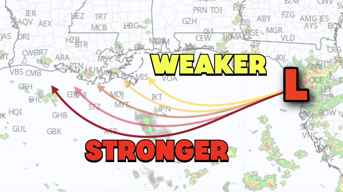
The thing to remember with Invest 93L: a more southern storm is stronger, whereas a northerly track is weaker. If it trends north, it encounters a bit drier air, has more proximity to land and less time over water to strengthen. A southern track could yield low-end hurricane.
3
6
25