Gulf of California
@GulfCalifornia
Followers
265
Following
11
Media
14
Statuses
47
The Gulf of California, also known as the Sea of Cortez, Sea of Cortés or Vermilion Sea, in Spanish lingo Mar de Cortés or Mar Bermejo or Golfo de California
Mexico
Joined December 2009
Maximum sustained winds are near 90 mph (150 km/h) with higher gusts. Strengthening is forecast during the next 24 hours, and Kay could become a major hurricane during that time.
0
0
0

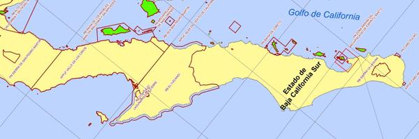
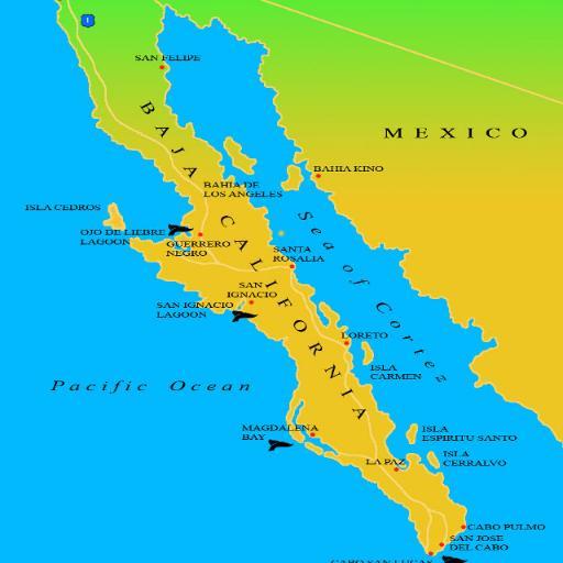
At 06:00hr Kay was about 590 km from the southern tip of the Baja peninsula. Strengthening is forecast during the next 36 hours, and Kay could become a major hurricane during that time. @La_Paz_BCS @LaPazMexico @PacenoPues
https://t.co/49SEiTyEFk

blog.baja-weather.com
At 06:00hr Kay was about 590 km from the southern tip of the Baja peninsula. Tropical storm conditions and areas of heavy rain expected to begin across southern Baja California peninsula by Wednesd...
0
2
1

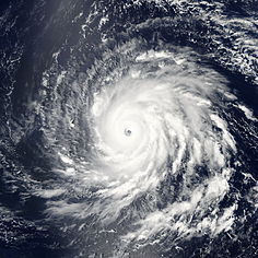
At 06:00hr Kay was about 590 km from the southern tip of the Baja peninsula. https://t.co/sV14FPsWjj
0
2
2
Yesterday at Los Muellecitos (north of Isla Partida which is separated from Isla Espíritu Santo by a shallow, narrow channel. #BCSIN @DesertBikesBCS @LaPazMexico @LaPazNet @deJongLuuk @lordoftheroach
0
1
4
In Fang Ming's wheelhouse - The Fang Ming was a Chinese ship of 54 meters in length that served to transport illegal immigrants; therefore it was confiscated by the government of Mexico. After a while, in 1999 it was sunk by in order to create an artificial reef.
0
0
0

Working hard, howling with the wolfes (lobos de mar)
0
3
4
This Baja island adventure was too easy. Then things got a little too real

latimes.com
A camping-and-snorkeling expedition to Isla Espiritu Santo showed the island’s rugged beauty and nature’s unpredictability.
0
2
3

Sunrise: 06:35hr, sunset: 18:29hr. Today, 10th of March 2020: 0% / 0 mm, cloudy, high temperature 26°C. Winds N at 10 to 15 km/h
1
1
1
At 07:00 hr CDT (12:00 hr UTC), the center of Tropical Storm Narda was located near latitude 16.6 North, longitude 101.4 West about 120 km (75 mi) S of Zihuatanejo and about 160 km (100 mi) WSW of Acapulco Mexico. https://t.co/MbPeko3gQL
0
1
1

‘There’s nothing there:’ Bahamian reporters weather Dorian, and the international press
0
1
2
At 07:00 hr CDT (12:00 hr UTC), the center of Tropical Storm Narda was located near latitude 16.6 North, longitude 101.4 West about 120 km (75 mi) S of Zihuatanejo and about 160 km (100 mi) WSW of Acapulco Mexico.
0
1
1
0
1
0
Michael Fishbach narrates his 2011 encounter with a humpback whale entangled in a fishing net. Fishbach spends two months in the Sea of Cortez (Gulf of California) every winter, photographing the Blue Finback... https://t.co/9GwElhbHOQ …
0
4
4

Heading for the Guaymas Basin in the Gulf of California before then crisscrossing the gulf in search of hydrothermal vents, underwater hot springs. https://t.co/JudMx3dt8I
0
1
0
Reflexiones sobre la ballena azul en el Golfo de California @IslaEspiriSanto @EcoToursBaja
0
1
2
President Enrique Pena Nieto personally reassured @LeoDiCaprio his government’s efforts to save rare porpoise https://t.co/qslSxfCg2G
0
13
3
0
1
1