
Ecopia AI
@EcopiaAI
Followers
847
Following
607
Media
653
Statuses
1K
Global supplier of high-precision mapping data digitizing the world using AI. #GIS #AI #Geospatial #Maps
Toronto, Ontario
Joined June 2013
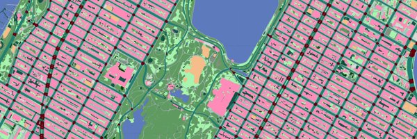
See how Ecopia's high-precision AI-powered geospatial data enables @altafieldnotes to: 🚲 Spot bike/ped gaps 🚧 Prioritize safety fixes 🌆 Mitigate urban heat 🚉 Analyze multimodal connectivity 💡 Power next-gen civic analytics https://t.co/hJGaNKqYPZ
0
0
0
GeoAI isn’t the future. It’s already here - and it’s elevating what’s possible in our industry. This recent @geoconnexion article by @briana_maps breaks down why GeoAI isn’t something to resist, it’s something to harness: https://t.co/5V4UCgCF5o
0
1
1
Join Thomas at 1pm for the Practical Implementations of Smart Water Solutions session where he’ll share how Ecopia’s highly accurate AI-powered geospatial data is being used to develop flood models, enhance climate resilience strategies, and monitor stormwater infrastructure.
0
0
0
Tomorrow, Thomas Peck will be presenting at the @WEAOntario’s Intelligent Water Solutions Seminar. https://t.co/Me6qa3Y0mz
1
0
0
The team at Ecopia wishes everyone a very happy GIS Day! 🗺️ From points to lines to polygons, vectors to rasters, DTMs to DSMs, 2D to 3D, and beyond, we’re proud to provide high-precision mapping data to organizations around the world for a wide variety of GIS applications.
1
0
0
This week Ecopia is headed to @geography2050! If you’ll be in New York for the symposium, be sure to catch our panel discussion with Tee Barr (@AmericanGeo ), Peter Wilczynski (@vantortech), and Sourav Mazumder (@IBM ) 🌍 Learn more: https://t.co/7PBHGTxO1Q
0
1
0
Creating safer streets begins with understanding existing infrastructure. Our latest blog explores how Ecopia’s data is helping: 🛣️ Uncover gaps in pedestrian infrastructure 🚌 Improve safe connections at transit stops 🚸 Prioritize new crosswalk locations, & more
1
0
0
Don’t miss our presentation at this week's @AWRAHQ Annual Water Resources Conference! We'll share how Ecopia’s detailed impervious surface, water, vegetation, and land cover datasets are used by governments across the nation for flood risk, stormwater management, & more.
1
0
1
This data is already in use by several governments & private organizations worldwide. Learn more in this recent article from @gim_intl
https://t.co/VeT5eqeLa4
0
0
0
ICYMI: Ecopia + @vantortech are transforming how we map the planet 🌎 By fusing AI + satellite imagery, we’re delivering high-precision 3D vector maps at a global scale - no manual digitization needed. Here’s a sample from Lisbon ⬇️
1
0
1
Thomas Peck will be at @PurdueLibraries GIS Day 2025! If you’ll be in West Lafayette this week, be sure to meet up with Thomas and learn more about Ecopia’s work in Indiana and around the world. Learn more and register here: https://t.co/PhSu9fyVwL
1
0
1
We are excited to sponsor the @AmericanGeo Fall Symposium: @geography2050! Don't miss the chance to catch up with our team in NYC and learn more about our exciting new global 3D mapping initiative with @vantortech 🌍 https://t.co/M6pmT19Cw3
0
1
1
🚨 Last Call to Register! 🚨 Wildfires are becoming more intense, more frequent, and more unpredictable. Don’t miss this timely discussion on wildfire readiness in the age of AI. 🔥
🔥 Wildfire readiness starts with accurate maps. Join @CAL_FIRE & Ecopia for a @nsgic webinar on October 29th at 2PM ET to learn how AI-powered geospatial data is transforming fire hazard mapping across California ⬇️ https://t.co/bh3XnMjjfh
0
0
0

📣Last call to register for today’s webinar hosted by @Visionzeronet! 🚦Join us at 1pm ET / 10 am PT to explore innovative tools that help communities assess critical transportation infrastructure and strengthen proposals to invest in change for safe streets.
2
0
0
Justin Proctor is presenting at futurenew, co-hosted by @BeSpatialON and @CanopyMappingCo! Don’t miss the chance to hear how Ecopia is spearheading Canada’s national mapping initiative with high-precision AI-powered data 🇨🇦 Register here ➡️ https://t.co/Q5qyrXRPib
0
0
0
➡️Read more to learn how Ecopia and Nearmap continue to drive innovation in the geospatial industry, delivering powerful, precise, and scalable solutions that enable smarter decision-making across industries: https://t.co/pyfgvMr9VY
0
0
0