

DL Scales
@DLScalesWX
Followers
3K
Following
10K
Media
470
Statuses
2K
StormRunner Media (Co-Owner) — Marriott Titanium Elite Member
Joined February 2022
147
514
2K
MAJOR FLASH FLOODING happening in NE Las Vegas, NV RIGHT NOW - Intersection of Lake Mead and Mt. Hood #nvwx @ReedTimmerAccu @NWSVegas
51
584
2K
Flooding occurring at the Intersection of 30th Ave and Date Palm Dr in Palm Springs, CA. @NWSSanDiego #CAwx
35
115
412

Timelapse of the initial development of the long-track supercell that travelled across Central Nebraska yesterday #NEwx @WeatherNation
8
81
403
This Supercell has directly hit multiple towns over the last 2 hours, including Rolling Fork, Silver City, and part of Winona, MS. Reports of severe damage, injuries, and death, including an infant (not confirmed). I’m not really religious recently but please pray for these


16
67
274

Unwarned #tornado crosses Hwy 34 east of Corning, IA, (3:25pm) destroying barns but luckily sparing a house. #IAwx #wxtwitter
6
43
229
4
40
178

3
30
131


We’re stuck in this currently lol.
This is I-15 near Jean and Primm. The southbound lane is impassable. That is all water. 👀

3
11
88


Violent #tornado crosses 60 in SE Missouri yesterday. @ChasingWConnor in front of us #mowx #wxtwitter

4
14
92
Hail up to golf ball sized (2 hours after storm passed) covering 487 north of Medicine Bow, WY #wywx @NWSCheyenne
6
21
91

Current conditions on I-17N near Munds Park, AZ #azwx @NWSFlagstaff @azfamily @abc15 @FOX10Phoenix @stormchaser1102
7
21
77


Timelapse of Wall Cloud development on a supercell near Emerson, IA around 7:30 PM #IAwx #wxtwitter
2
6
68
Everyone enjoy this moment, it might be the only time in history all of wxtwitter came together and agreed on something.
4
3
73


3
10
60

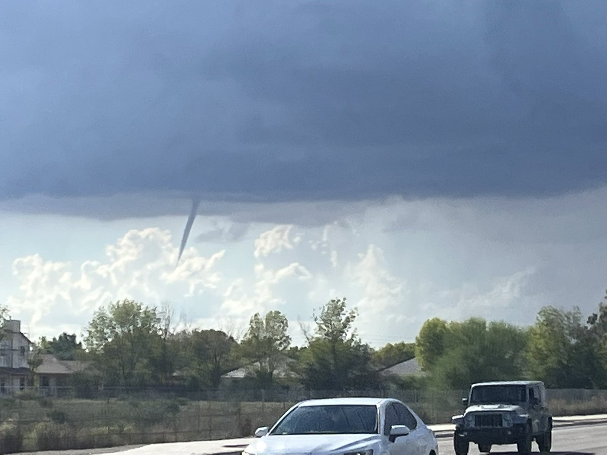
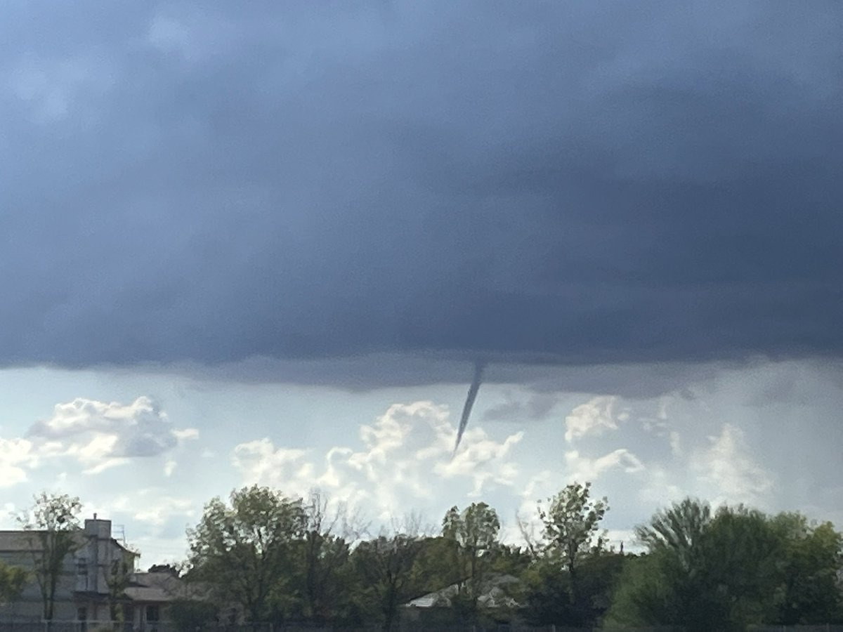
Video of the landspout TORNADO near Chandler, AZ about an hour or so ago. @azfamily @FOX10Phoenix @NWSPhoenix @WeatherNation #azwx
2
6
58

2
8
58
I will be streaming this LIVE on YouTube later this afternoon, be sure to tune in!

12
11
62
Power lines down + metal shed damage. Possibly tornado or microburst. Just outside Tonopah, AZ at 10pm #azwx @nwsphoenix


2
16
61
This was the scene near the base of Mount Elden, in Flagstaff, AZ #azwx @azfamily @NWSFlagstaff @stormchaser1102
1
13
55
Major Flooding in Big Chino Wash after Heavy Rain and Snow Melt - Chino Valley, AZ (3-22-23) #azwx @NWSFlagstaff @azfamily @FOX10Phoenix @abc15 @12News @WeatherNation
4
18
57
Multiple rollovers on I-40 east due to very strong cross winds associated with this supercell @NWSAlbuquerque @LiveStormChaser #nmwx

1
12
54
Day 1 nicotine free. Trying my best to be healthier in 2025. I’ve attempted to quit in the past but have always fallen back into bad habits, hoping this time to permanently kick the habit.
9
1
60
Today was the first time any of my video really got any semi major attention. Didn’t know the embed thing was a feature on here, my bad y’all. Still new to this.
3
2
58

5
16
51

Thank you to @BrandonCopicWx and @CoreyGerkenWX for helping us change out a flat tonight!! Appreciate yall so much!.
3
0
57
Baseball Sized Hail in Lewis KS about 5 minutes ago! @NWSDodgeCity #kswx.@breakingweather @WeatherNation


4
7
56
Choosing not to go to Nebraska might be one of the biggest fumbles I’ve ever had. This storm just won’t die.
1
0
57
Thank you to our sponsor, Prescott Tire Pros, for getting the StormRunner chase ready for our full time chasing, starting next week!

6
2
51
Hail core intercept on the supercell NE of Amarillo, TX moments ago - hail up to golf balls estimated #txwx #wxtwitter
2
9
53
Absolutely beautiful supercell that produced DVD SIZED HAIL west of Lubbock, TX today #txwx #wxtwitter


3
10
49
After 7 months of saying I’d never chase western Arkansas, I found myself there yesterday. I can confirm I’m back to saying I’ll never chase there again.
14
1
54
Conditions quickly getting worse on I-17 south of Flagstaff amid frontal passage snow #azwx @NWSFlagstaff
0
8
49


5
4
48
The Cole, OK tornado ; My first close-up tornado intercept. Only thing between me and it was @BrandonCopicWx 😂👍🏽 #okwx
2
2
48


Driving from Iowa to Texas overnight sounded a lot easier in my head….
7
0
43

Extremely strong winds combining with heavy snowfall are creating BLIZZARD conditions in Prescott Arizona! #azwx @stormchaser1102 @WeatherNation @LiveStormChaser @NWSFlagstaff @breakingweather @weatherchannel
4
12
40
Major flooding in tonopah, AZ. Cars stuck. We are trapped between 2 floods atm, we are ok though @NWSPhoenix @stormchaser1102 @WeatherNation #azwx
5
14
43
After 24 straight hours of snow coverage and helping folks stuck when we could, we came across a gentleman with a blown tire and were able to change it for him on our way home. Always thankful to be able to help people out. Thanks @BrandonCopicWx for training me in tire changing.
2
3
44
Insane Rapid Intensification on #hurricane #milton! 160mph Category 5! En route to cover landfall in Florida. #flwx

4
6
43


Power poles down on W Patton Rd. We measured 60mph winds from a downburst a few hundred feet back using our Davis Vantage Vue. @NWSPhoenix @abc15 @azfamily @FOX10Phoenix @LiveStormChaser #azwx @SchwartzTV @AmberSullins
6
15
37
Looks like my intuition not to drive to Missouri was correct. Woke up this morning to a complete electrical malfunction. The car is behaving as if it was struck by lightning lol. Beginning of the end perhaps

10
2
42

CONFIRMED TORNADO WITH GROUND CIRCULATION on the ground minutes ago southwest of Chandler, AZ near I-10. Was on the ground for about 5 minutes. @WeatherNation @NWSPhoenix @azfamily @FOX10Phoenix @storyfulviral #azwx

4
16
36

To chase or not chase this Oregon slight risk in the RentalRunner 🤔🤔

6
0
37


3
7
36

HD photo of me not being prepared.


2
1
36
Potentially a Rotating Wall Cloud 15 miles N of Boise City, OK on Severe T-Storm @NWSAmarillo #OKwx
3
3
34
Wind damage from a #severewarned #Thunderstorm 30 miles east of Gila Bend, AZ at the I8 & HWY 84 moments ago! @NWSPhoenix @FOX10Phoenix @abc15 @azfamily @SchwartzTV #azwx

4
5
34
I’ve been doing my best to get healthier; I’ve started meal-planning, largely cut out fast food, go for runs every morning and hit the gym 4 times a week. I’ve even been going to therapy. And yet, my mental health just gets worse and worse everyday. I apologize to StormRunner.
16
0
35
I leave for 4 days….

4
0
32

I avoid twitter for a week, then pop in for 5 minutes, just to be reminded why I stayed off for a week in the first place.
5
1
34

Eerie scene just north of Elida. NM with Flash Flooding blocking Rd 330. @WeatherNation @LiveStormChaser #nmwx
2
8
28