

Extreme & Convective Events
@ConvectiveUK
Followers
3K
Following
30K
Media
1K
Statuses
6K
Forecasting Thunderstorms & Convective events within the British Isles. Forecasted by a small group of amateur meteorologists.
Weather Forecast
Joined February 2022
RT @Handry_Outlook: Few heavy showers will affect many parts of England and Wales this afternoon, some of them will be gusty and thundery,….
0
1
0
Monday 18th August:. Thunderstorms & intense showers are expected to develop during the early morning across the Celtic sea pushing into S/SW parts of Ireland. Frequent lightning and the most intense storms can be expected across extreme S Ireland.

1
2
14

Blazing-fast image creation – using just your voice. Try Grok Imagine.
283
556
3K
RT @iranianb1tch: @ConvectiveUK I can report confirmed lightning strikes and intense rain yesterday in Shoreditch, London (I saw it with my….
0
1
0
RT @UKStormUpdates: Thunderstorm ongoing to the east of Elgin in Scotland. Radar from WQRadar.

0
2
0
Wednesday 13th August 2025:. T-storm are expected to develop across SW of Ireland, NE of Ireland into N Ireland with more intense T-storms expected to affect Scotland. Frequent lightning, large hail can all be expected from these storms. Isolated / sporadic lightning elsewhere

3
4
23
RT @PeterChailey: One of the nicest separations I’ve seen so far tbh. May have had a funnel cloud off it as well, will be interesting to se….
0
4
0
Thursday 31st July - UPDATE:. Thunderstorms turning quite severe into the afternoon, bringing tornadic, wind & flooding problems across the South. Lightning is expected to turn frequent across CS/SE England, where the strongest storms are expected. Sporadic lightning elsewhere.

Thursday 31st July:. Thunderstorms & intense showers will develop quite widely across S England, focusing closely towards CS / SE England. Sporadic lightning is expected which may turn frequent at times. Update tomorrow!

1
5
27
Thursday 31st July:. Thunderstorms & intense showers will develop quite widely across S England, focusing closely towards CS / SE England. Sporadic lightning is expected which may turn frequent at times. Update tomorrow!
2
4
23

RT @Steadyeddie41: @UKStormUpdates There has been flash flooding in Hastings. I live here and local social media showing flash flooding and….
0
4
0


Wednesday 23rd July 2025:. Convergence lines will allow intense showers and thunderstorms to develop across S England up to EA. CAPE values is expected to exceed 500J/KG allowing sporadic potentially frequent lightning for a time. Tornado's & flooding are the reason for the SVR.

1
3
25
Tuesday 22nd July:. Heavy showers will develop across Ireland & parts of England, sporadic lightning may be seen in a few of these showers. Risk of lightning is fairly low today, therefore a LOW Risk has been issued.

0
1
20

Monday 21st July:. Thunderstorms will develop quite widely across England & parts of Scotland where higher lightning frequency can be expected across N England & EA/SE England. Overall lightning will remain sporadic with times where it could be frequent.

2
4
25
Sunday 20th July:. Thunderstorms will develop quite widely today across England, Ireland & Scotland. Lightning activity will remain sporadic, however could become frequent at times.

2
8
40
Technical issue on creating a graphic for today's forecast, apologies to all. This issue should be fixed by tonight, so an outlook will be produced for tomorrow!. Here is a highly accurate forecast 🔽.

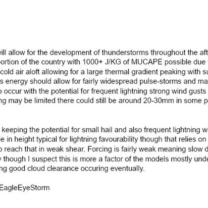
THUNDERSTORM WATCH - SAT 19 JULY 2025.Issued 2025-07-19 10:27:20.Valid: 19/07/2025 0900 to 20/07/2025 0600. Forecast Details 👇.

0
1
13
This SLGHT Risk should also contain SVR which we have forgot to add in todays Graphic. Apologies to all who may become confused.
1
0
7